Engineering 3D Scanning for Industrial and Infrastructure Projects in Thailand

Engineer using LiDAR scanner to capture industrial plant within a map of Thailand, representing engineering 3D scanning for infrastructure and manufacturing projects.

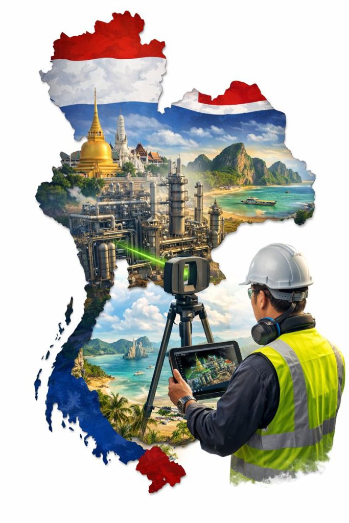
Engineering 3D Scanning for Industrial Projects in Thailand

Supporting safer, faster and more accurate upgrades across manufacturing and processing facilities

Thailand is one of Southeast Asiaโ€™s major industrial hubs, with large manufacturing estates, petrochemical complexes, power generation facilities and transport infrastructure supporting both domestic and export markets. As these facilities continue to expand and modernise, engineering teams are increasingly relying on 3D laser scanning and reality capture to improve design accuracy and reduce construction risk in operating environments.

Engineering-grade 3D scanning is becoming a critical tool for supporting plant upgrades, retrofit projects and infrastructure works where accurate as-built information is essential.


Why As-Built Accuracy Matters in Thai Industrial Facilities

Many industrial sites in Thailand have developed over long periods, with multiple upgrades, expansions and equipment replacements. As a result, existing drawings often no longer reflect actual site conditions.

This creates challenges such as:

  • Unknown clashes with existing services
  • Limited access for installation and maintenance
  • Increased shutdown risk
  • Safety hazards during construction

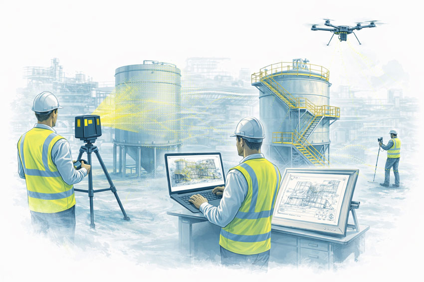
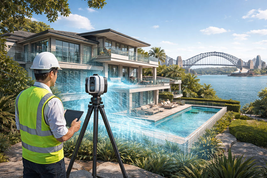
Engineering-grade laser scanning captures high-density point cloud data that accurately reflects the current state of the facility, giving engineers confidence that designs will fit before work begins on site.


Key Applications of Engineering 3D Scanning in Thailand

Manufacturing Plant Upgrades

Thailandโ€™s automotive, electronics and food processing industries frequently upgrade production lines to improve throughput and automation. Laser scanning allows new machinery and conveyors to be designed directly into existing layouts, reducing installation issues and commissioning delays.


Industrial facility in Thailand being digitally captured with 3D scanning to create accurate models for engineering and upgrade planning.

Petrochemical and Process Facilities

Process plants rely on precise pipework, structural and equipment interfaces. Scanning supports:

  • Tie-in design
  • Pipe routing verification
  • Structural modification planning
  • Safety and access reviews

This is particularly valuable when modifications must be completed during short shutdown windows.

Power and Utilities Infrastructure

Power stations, substations and utility facilities benefit from accurate spatial data for:

  • Equipment replacement
  • Structural strengthening
  • Cable routing upgrades
  • Maintenance planning

3D scanning enables safer design development with fewer site visits in high-risk areas.

Transport and Civil Infrastructure

For stations, depots, bridges and industrial precincts, reality capture supports:

  • Retrofit design
  • Clearance verification
  • Construction staging and access planning

Providing reliable geometry where traditional surveys may be difficult or disruptive.


Why Engineering-Grade LiDAR Is Essential for Industrial Projects

Not all scanning systems are suitable for engineering design.

Industrial and infrastructure projects typically require:

  • Millimetre-level accuracy
  • Long-range scanning capability
  • Reliable reference for CAD and BIM modelling
  • Robust performance in harsh environments

Engineering-grade LiDAR scanners are designed to meet these requirements, making them suitable for mechanical, structural and services design where tolerances and constructability are critical.

Visual scanning platforms are valuable for documentation and communication, but fabrication and installation planning depend on higher-accuracy capture methods.


Benefits for Project Teams and Asset Owners

When integrated into engineering workflows, 3D scanning delivers clear project advantages:

  • Reduced re-measurement on site
  • Improved design confidence
  • Fewer construction clashes
  • Shorter shutdown durations
  • Safer design development
  • Better coordination between disciplines

For facilities operating at high production capacity, reducing downtime and rework has significant financial impact.


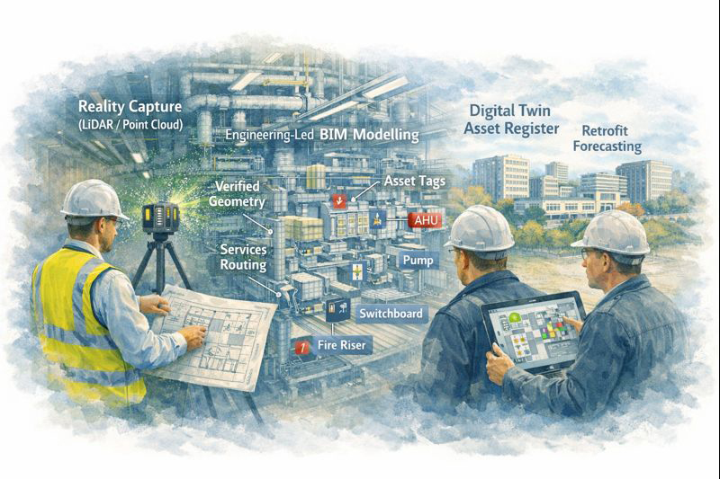
Engineering-Led Reality Capture Workflows

The true value of scanning lies not just in capturing data, but in how that data is used.

Engineering-led reality capture integrates point cloud data into:

  • Mechanical and structural design
  • Scan-to-CAD and Scan-to-BIM modelling
  • Fabrication drawing development
  • Installation planning and verification

This ensures scanning directly supports project delivery, not just documentation.


Supporting Industrial Growth Across Southeast Asia

Thailand continues to invest heavily in industrial development, automation, energy infrastructure and transport networks. Engineering-grade reality capture supports this growth by enabling:

  • Faster project start-up
  • Better design coordination
  • Reduced construction risk

As facilities become more complex, accurate digital site data becomes a critical foundation for future upgrades and long-term asset management.


Final Thoughts

For industrial and infrastructure projects in Thailand, 3D laser scanning is no longer a specialist technology โ€” it is a practical engineering tool that supports safer, more efficient and more predictable project delivery.

When combined with mechanical and structural engineering expertise, reality capture enables teams to design, coordinate and construct with greater confidence in some of the regionโ€™s most complex operating environments.

Name
Would you like us to arrange a phone consultation for you?
Address

Digital Twin Creation & Long-Term Asset Management

Digital twin created from LiDAR scanning showing asset tags and maintenance planning in industrial facility

Digital Twin Asset Management Sydney | Hamilton By Design

From Point Cloud to Digital Twin: Better Asset Control for Sydney Precincts

For asset owners and facilities managers across Greater Sydney and the Central Coast, accurate and accessible building data is no longer a luxury โ€” it is critical for maintenance planning, compliance, risk management, and future upgrades.

Yet many facilities still rely on incomplete drawings, outdated asset registers, or disconnected documentation spread across multiple systems.

At Hamilton By Design, we use high-accuracy 3D scanning and engineering-led modelling to create digital twins โ€” intelligent, data-rich representations of real facilities that support long-term asset management, not just one-off construction projects.


Why Traditional Building Records Fall Short

Over the life of a facility, buildings change constantly:

  • Services are upgraded or rerouted
  • Plant is replaced or relocated
  • Structural movement occurs over time
  • Temporary works become permanent
  • Documentation becomes fragmented or lost

As a result, asset owners are often forced to make decisions based on assumptions instead of verified data, increasing operational risk and lifecycle costs.

Digital twins replace uncertainty with measurable, current, and verifiable building intelligence.


What Is a Digital Twin โ€” and Why It Matters

A digital twin is more than a 3D model. It is a continuously usable digital representation of your physical asset that can support:

  • Asset lifecycle management
  • Maintenance planning and scheduling
  • Retrofit and upgrade forecasting
  • Compliance verification and reporting
  • Insurance documentation and risk mitigation

Using LiDAR and reality capture, we first create highly accurate point cloud data of your facility. This is then converted into structured engineering models and documentation, forming the foundation of a usable digital twin environment.


Supporting the Full Asset Lifecycle

Digital twins created by Hamilton By Design are designed to support decision-making across the entire life of an asset.

Asset Lifecycle Management

Digital twins provide a verified reference for:

  • Plant locations and access paths
  • Service routing and capacity
  • Structural geometry and tolerances
  • Interface points between systems

This allows asset teams to plan interventions without repeated site surveys or intrusive investigations.


Maintenance Planning and Access Strategy

Maintenance activities often fail not due to equipment faults, but due to poor access planning and unknown service constraints.

Digital twins allow teams to:

  • Visualise maintenance access zones
  • Plan shutdown sequences
  • Coordinate contractor access safely
  • Reduce unexpected site conditions

This is particularly valuable in hospitals, transport facilities, and industrial plants where downtime is extremely costly.


From point cloud to digital twin for lifecycle management of Sydney industrial and precinct assets

Retrofit and Upgrade Forecasting

When assets age, upgrade programs become unavoidable โ€” but without accurate models, forecasting becomes unreliable.

With digital twins, asset owners can:

  • Test retrofit scenarios digitally
  • Assess spatial constraints early
  • Coordinate staged construction programs
  • Validate new services layouts before installation

This significantly reduces redesign cycles and programme risk.


Compliance, Insurance and Risk Documentation

High-accuracy digital records also support:

  • Compliance audits
  • Fire and safety system verification
  • Engineering certification
  • Insurance risk assessments

Digital twins provide verifiable evidence of current conditions, which is increasingly important for regulatory and insurer requirements.


Enterprise-Value Scanning, Not Just Project Scanning

Many scanning services stop at delivering point clouds. Hamilton By Design goes further by integrating scanning into an engineering and asset management workflow.

Our service extends beyond capture into:

  • Mechanical engineering interpretation
  • Systems modelling and coordination
  • Project and asset integration support
  • Fabrication and modification planning

This makes digital twins a strategic asset tool, not just a design input.


Construction, Operations and Future-Proofing โ€” All in One Model

Our digital twin workflows support:

  • Operational facilities
  • Construction planning
  • Ongoing modifications
  • Future asset strategies

By maintaining continuity between engineering, construction, and asset management data, digital twins become a single source of truth for multiple stakeholders.


Deliverables Designed for Asset Teams

We provide digital twin outputs in formats compatible with enterprise asset and design systems:

  • High-resolution point clouds (RCP / E57)
  • Revit asset models
  • AutoCAD documentation
  • SolidWorks equipment and systems models
  • Asset-aligned 2D drawings
  • Data structured for future updates

These can be used directly by engineering consultants, maintenance teams, and facilities management platforms.


Supporting Sydney and Central Coast Asset Portfolios

We work with asset owners across:

  • Healthcare precincts
  • Commercial property portfolios
  • Industrial facilities
  • Infrastructure and transport sites
  • Education campuses
  • Heritage and government assets

Our local support allows ongoing engagement as facilities evolve, not just one-off capture projects.


Turn Building Data into an Asset Strategy

Digital twins transform buildings from static structures into data-driven, manageable systems.

They allow asset owners to move from reactive maintenance to planned lifecycle control, improving reliability, safety, and financial predictability.


Hamilton By Design logo displayed on a blue tilted rectangle with a grey gradient background

Arrange a Digital Twin Consultation

If you are responsible for long-term facility performance, compliance, or upgrade planning:

Please fill out the form below to arrange a phone consultation.

Weโ€™ll discuss your asset portfolio, operational requirements, and long-term objectives, and recommend a digital twin strategy that supports both current operations and future upgrades.

Name
Would you like us to arrange a phone consultation for you?
Address

Drafting Capacity for Todayโ€™s Projects: An Integrated Scan โ†’ Model โ†’ Detail โ†’ Check Workflow

Drafting Capacity for Todayโ€™s Projects | Engineering-Led Documentation

Engineering and construction projects are increasingly delivered under compressed timeframes, constrained resources, and heightened compliance expectations. In this environment, access to reliable drafting capacityโ€”supported by robust processesโ€”is critical to maintaining quality and reducing project risk.

Hamilton By Design provides experienced drafting capacity, available for short-term support or longer-term secondment, delivered within a structured scan โ†’ model โ†’ detail โ†’ check workflow that aligns documentation with real-world conditions and engineering intent.


Drafting capacity aligned with contemporary project demands

Modern projects often require drafting support that can scale quickly to address:

  • Peak workloads during design development or shutdown preparation
  • Short-term resourcing gaps within engineering teams
  • Documentation demands driven by upgrades, modifications, or compliance works
  • Brownfield environments where existing information is incomplete or unreliable

In these situations, drafting capacity must be more than transactional. It must integrate with engineering workflows and reflect current site conditions.


Scan: establishing an accurate technical baseline

Where existing drawings cannot be relied upon, accurate documentation begins with engineering-grade reality capture.

Our team utilises 3D laser scanning to establish a defensible geometric baseline of existing assets. This approach supports drafting activities by ensuring that models and drawings are developed from verified site data, rather than assumptions or legacy documentation.


Model: structured CAD developed for engineering use

Scan data is translated into purpose-built CAD models, developed to suit the intended engineering and documentation outcomes. Models are structured with appropriate datums, tolerances, and levels of detail to support:

  • Engineering assessment and design coordination
  • Structural and mechanical detailing
  • As-built documentation and future modification

This modelling stage ensures drafting activities are grounded in usable, engineering-aligned data.


Detail: producing clear, buildable documentation

Drafting output remains one of the most critical interfaces between design and construction.

From verified models, our draftspersons produce clear, fabrication-ready drawings that communicate engineering intent accurately and unambiguously. Documentation is prepared with consideration for:

  • Constructability and sequencing
  • Fabrication practicality
  • Coordination between disciplines
  • Alignment with relevant Australian Standards

The emphasis is on documentation that can be confidently issued to site.


Check: verification as a formal step, not an afterthought

Before issue, drawings and models are subject to structured review to confirm:

  • Consistency with scan data and models
  • Coordination across views and drawing sets
  • Technical clarity and buildability

This checking step reduces the likelihood of downstream rework and supports defensible documentation outcomes.


Why integrated drafting capacity matters

When drafting is separated from scanning, modelling, or checking, risk is introduced at each handover.

An integrated scan โ†’ model โ†’ detail โ†’ check workflow:

  • Improves documentation reliability
  • Reduces errors caused by assumptions
  • Supports compliance and verification
  • Enhances confidence during fabrication and construction

This approach is particularly effective for existing assets, industrial facilities, and brownfield upgrades.


Flexible drafting support and secondment

Hamilton By Designโ€™s drafting capacity can be provided as:

  • Short-term drafting support
  • Longer-term secondment within client teams
  • Targeted assistance during high-demand project phases

Drafting support is delivered within an engineering-led environment, ensuring alignment between documentation and technical intent.

To learn more about flexible resourcing options, visit our Secondment Services page:
๐Ÿ‘‰ https://www.hamiltonbydesign.com.au/home/secondment-services/


Hamilton By Design logo displayed on a blue tilted rectangle with a grey gradient background

Conclusion

As project complexity and delivery pressures continue to increase, drafting capacity must be current, integrated, and accountable.

By providing experienced draftspersons supported by a structured scan โ†’ model โ†’ detail โ†’ check workflow, Hamilton By Design enables project teams to scale documentation capability without compromising accuracy, buildability, or engineering quality.

Name
Would you like us to arrange a phone consultation for you?
Address

Australian Standards That Shape Engineering, Scanning & Documentation Projects

Australian Standards play a critical role in how engineering, design, and construction work is delivered โ€” particularly on industrial, mining, power, and brownfield projects where safety, reliability, and compliance matter.

At Hamilton By Design, engineering services, 3D scanning, CAD modelling, and as-built documentation are delivered with a clear understanding of how Australian Standards inform real-world engineering decisions. Rather than treating standards as a checklist, they are applied as part of a practical, engineering-led workflow.


Why Australian Standards matter in real projects

Australian Standards exist to ensure that structures, equipment, and systems are:

  • Safe to build, operate, and maintain
  • Fit for their intended purpose
  • Designed and documented consistently
  • Defensible if designs are reviewed or audited

On existing sites, outdated drawings and undocumented modifications make standards-based assessment even more important. Accurate data, clear documentation, and sound engineering judgement are essential to applying standards correctly.


Key Australian Standards referenced across our work

The following Australian Standards are commonly referenced across Hamilton By Design projects and content, particularly where engineering, scanning, drafting, and compliance intersect.


AS 1657 โ€“ Fixed platforms, walkways, stairways and ladders

This standard governs access systems used for operation and maintenance.

It is frequently applied when:

  • Assessing existing platforms and walkways
  • Designing upgrades or retrofits
  • Verifying clearances, handrails, and access geometry

Engineering-grade as-built information is often required to accurately assess compliance on existing sites.


AS 3990 โ€“ Mechanical equipment steelwork

AS 3990 applies to steelwork that supports mechanical equipment.

It is commonly referenced for:

  • Equipment support frames
  • Plant steelwork and interfaces
  • Integration of access systems with equipment

Accurate geometry and documentation are essential when modifying or extending existing steelwork.


AS 4100 โ€“ Steel structures

AS 4100 forms the basis for the design and assessment of steel structures.

This standard is applied to:

  • Structural steel framing
  • Platforms, walkways, and support structures
  • Structural upgrades and strengthening works

Structural engineering decisions rely on accurate understanding of existing member sizes, connections, and load paths.


AS 4991 โ€“ Lifting devices

AS 4991 covers the design and use of lifting devices.

It is relevant when:

  • Designing or modifying lifting points
  • Documenting lifting arrangements
  • Assessing existing lifting equipment

Clear engineering documentation supports safe lifting operations and ongoing compliance.


AS 4024 โ€“ Safety of machinery

AS 4024 relates to machinery safety and risk control.

It is typically referenced where:

  • Machinery interfaces with structures or access systems
  • Guarding or safety systems are affected by modifications
  • Engineering changes may impact operator safety

AS 1100 โ€“ Technical drawing (implied through documentation workflows)

AS 1100 governs technical drawing conventions.

While not always referenced explicitly, it underpins:

  • Engineering drawings
  • Structural and mechanical drafting
  • As-built documentation

Clear, standardised drawings are essential for construction, fabrication, and future asset modifications.


National Construction Code (NCC)

The NCC provides a regulatory framework for building compliance.

Engineering and documentation workflows often support:

  • Existing building upgrades
  • Compliance verification
  • Safety-in-design obligations

Accurate as-built documentation helps ensure engineering decisions align with NCC requirements.


The role of 3D scanning and as-built data in standards-based engineering

Australian Standards often require engineers to understand what actually exists on site, not just what is shown on legacy drawings.

Engineering-grade 3D laser scanning and LiDAR are used to:

  • Capture accurate geometry of existing assets
  • Identify undocumented modifications
  • Support standards-based assessment and design
  • Produce reliable as-built documentation

This is particularly important on brownfield and live sites where assumptions introduce risk.


Applying standards with engineering judgement

Australian Standards do not replace engineering judgement โ€” they rely on it.

Effective application of standards requires:

  • Accurate site information
  • Understanding of real operating conditions
  • Clear documentation of assumptions and limitations
  • Coordination between engineering, drafting, and construction

This is why standards, scanning, drafting, and engineering must work together as part of a single workflow.


Our clients:


Final thoughts

Australian Standards provide the framework for safe and compliant engineering, but outcomes depend on how they are applied.

By combining engineering expertise with accurate data capture and clear documentation, standards can be applied confidently โ€” reducing risk, improving safety, and delivering better long-term asset performance.


Hamilton By Design logo displayed on a blue tilted rectangle with a grey gradient background

Need standards-aware engineering support?

If your project involves upgrades, existing assets, or compliance-driven design, engineering-led scanning, drafting, and documentation can make all the difference.

Hamilton By Design supports projects where Australian Standards, engineering judgement, and real-world conditions must align.

Name
Would you like us to arrange a phone consultation for you?
Address

What Is the Difference Between a Terrestrial Scanner and a LiDAR Scanner?

Terrestrial, mobile SLAM and drone LiDAR scanners capturing an industrial plant with engineers reviewing point cloud data and drawings

Terrestrial vs LiDAR Scanners | Whatโ€™s the Difference?

Confusion around terrestrial scanning and LiDAR scanning is common โ€” and understandable.
The two terms are often used interchangeably, even though they describe different things.

This page explains the difference in plain language, shows where each approach fits, and helps you decide what level of accuracy and risk is appropriate for your project.


Short Answer (If Youโ€™re in a Hurry)

LiDAR describes the laser measurement technology.
Terrestrial describes how and where that LiDAR scanner is deployed.

Most terrestrial scanners use LiDAR, but not all LiDAR scanners are terrestrial.


Illustration comparing terrestrial LiDAR, mobile SLAM LiDAR and drone scanning on an industrial facility

What Is LiDAR?

LiDAR (Light Detection and Ranging) is a method of measuring distance using laser light.

How LiDAR works

  • A laser pulse is emitted
  • The pulse reflects off an object
  • The return time is measured
  • Distance is calculated and stored as a 3D point

Millions of these points form a point cloud that represents real-world geometry.

What LiDAR is good for

  • Accurate 3D measurement
  • Complex geometry
  • Low-light or enclosed environments
  • Engineering, construction, and industrial sites

LiDAR answers: How is distance measured?


What Is a Terrestrial Scanner?

A terrestrial scanner is a ground-based scanning system, usually mounted on a tripod or fixed position.

Key characteristics

  • Fixed scan position
  • Controlled setup and coverage
  • Known geometry and reference
  • High repeatability and validation

Typical environments

  • Processing plants and CHPPs
  • Structural steelwork
  • Conveyor systems
  • Brownfield tie-ins
  • As-built verification
  • Shutdown-critical fit-up work

Terrestrial answers: Where and how is the LiDAR deployed?


How the Two Terms Relate (This Is the Important Part)

A terrestrial scanner is a platform.
A LiDAR scanner is a technology.

Most modern terrestrial scanners are terrestrial LiDAR scanners.

Example: a tripod-mounted system such as the FARO Focus S-Series is:

  • LiDAR-based (laser measurement)
  • Terrestrial (ground-based, fixed setup)

Other Common LiDAR Scanner Types (And Why It Matters)

Scanner TypeHow Itโ€™s UsedTypical Outcome
Terrestrial LiDARTripod / fixedHighest control & accuracy
Mobile / SLAM LiDARHandheld / walk-throughFast capture, lower control
Vehicle-mounted LiDARCar / trolleyCorridor mapping
Aerial LiDARDrone / aircraftLarge areas, low detail

All are โ€œLiDARโ€, but not all are suitable for engineering design or fabrication.


Why This Distinction Matters for Projects

Many issues occur when:

  • A LiDAR scan is assumed to be engineering-grade
  • A mobile or SLAM scan is used beyond its intent
  • Accuracy, validation, or limitations are not clearly understood

This doesnโ€™t mean one method is wrong โ€” it means each has a purpose.

The key is aligning the scanner type with:

  • Required accuracy
  • Risk tolerance
  • Fit-up criticality
  • Intended use of the data

Our clients:


Simple Decision Guide (Client in Control)

If you need:

  • Fabrication or replacement parts โ†’ Terrestrial LiDAR
  • Shutdown-critical fit-up โ†’ Terrestrial LiDAR
  • Structural verification โ†’ Terrestrial LiDAR
  • Rapid site context only โ†’ Mobile / SLAM LiDAR
  • Large terrain or stockpiles โ†’ Aerial LiDAR

There is no โ€œone best scannerโ€ โ€” only the right scanner for the outcome you want.


Comparison at a Glance

RequirementTerrestrial LiDARMobile / SLAM LiDAR
Accuracy controlHighModerate
RepeatabilityHighLower
Engineering defensibilityStrongLimited
Fit-up confidenceSuitableNot recommended
Capture speedSlowerFaster
Best use caseDesign & fabricationVisualisation & context

A Note on Engineering Use

Where scanning data feeds into engineering design, documentation, or fabrication, higher-control methods are typically required to align with engineering practice and Australian Standards expectations.

That doesnโ€™t remove choice โ€” it simply means the assumptions and limitations must match the intended use.


How We Approach This (Without Locking You In)

Weโ€™re happy to:

  • Work with terrestrial, mobile, or supplied scan data
  • Validate data before design where required
  • Align scanning effort with your risk, budget, and outcome
  • Clearly document assumptions and limitations

You stay in control of the approach โ€” our role is to make sure the data supports the outcome you expect.


Hamilton By Design logo displayed on a blue tilted rectangle with a grey gradient background

Next Step

If youโ€™re unsure which scanning method suits your project:

Fill out the contact form and tell us:

  • What you want to build, replace, or verify
  • How the data will be used
  • Any constraints (budget, time, shutdown windows)

Weโ€™ll help you select a fit-for-purpose scanning approach, not just a scanner.


Name
Would you like us to arrange a phone consultation for you?
Address

Reality Capture Sydney for Real Estate & Property Assets

Engineer using a LiDAR scanner to capture a Sydney harbour-front residential property with Sydney Harbour Bridge in the background

Reality Capture Sydney for Real Estate & Property Assets

High-Accuracy Digital Records and Premium Visual Context

Sydneyโ€™s real estate and commercial property market demands accurate information, clear presentation, and confidence in decision-making. Whether supporting leasing, refurbishment, due diligence, or long-term asset management, reality capture in Sydney provides property owners and managers with a reliable digital record of what exists today.

Hamilton By Design delivers professional reality capture services in Sydney, combining high-accuracy spatial data with high-end visual outputs suited to commercial and premium property assets.


Reality capture of a Sydney waterfront residential property using LiDAR scanning with harbour and bridge context

What Is Reality Capture for Real Estate?

In a property context, reality capture is the process of digitally recording buildings and spaces using advanced laser scanning and spatial capture technologies. The result is a dimensionally accurate digital representation of an asset that can be reused across multiple projects without repeated site visits.

Reality capture is commonly used across Sydney for:

  • Accurate existing-condition records
  • Leasing and tenancy planning
  • Commercial fit-outs and refurbishments
  • Asset documentation and compliance support
  • Due diligence during acquisition or divestment

Unlike traditional photography or basic floor plans, reality capture provides measurable, verifiable data that reduces uncertainty and risk.


High-End Capture of Sydneyโ€™s Harbour & Landmark Context

For premium assets, context matters. Hamilton By Design captures high-resolution reality capture imagery that includes Sydneyโ€™s built environment and surrounding landmark context, where appropriate.

This may include:

  • Harbour-front commercial buildings
  • Assets with views or proximity to Sydney Harbour
  • Visual context incorporating the Sydney Harbour Bridge
  • CBD and waterfront developments

These high-end visuals support investor presentations, leasing material, and executive-level decision-making, while remaining grounded in accurate spatial data.


Why Reality Capture Matters in Sydneyโ€™s Property Market

Sydney properties often involve:

  • High asset values
  • Live, occupied buildings
  • Tight refurbishment timeframes
  • Complex services and structural interfaces

Reality capture helps property stakeholders to:

โœ” Verify what exists before committing capital
โœ” Reduce surprises during refurbishments
โœ” Support consultants with reliable base information
โœ” Minimise disruption to tenants
โœ” Maintain a long-term digital record of the asset

For property owners and managers, this translates directly to reduced risk and better outcomes.


Typical Real Estate Applications

As-Built Property Records

Create accurate digital records where original drawings are missing, outdated, or unreliable.

Leasing & Tenancy Planning

Support test fits, space planning, and consultant coordination with trusted spatial data.

Refurbishment & Upgrade Projects

Capture existing conditions prior to works to reduce redesign, delays, and cost overruns.

Due Diligence & Asset Review

Provide clarity and confidence during acquisition, divestment, or asset reviews.


A Professional, Asset-Focused Approach

While many services focus on visual outputs alone, Hamilton By Design approaches reality capture from an asset and decision-support perspective. Our deliverables are:

  • Dimensionally reliable
  • Fit for professional use
  • Suitable for consultants and contractors
  • Appropriate for commercial and executive audiences

This ensures reality capture data can be relied upon when property decisions carry financial and contractual significance.


Deliverables to Suit Property Clients

Depending on your requirements, we can provide:

  • Registered point clouds
  • CAD-ready base files
  • Accurate spatial references
  • Section views and area verification
  • Digital records suitable for future upgrades

All outputs are tailored to the intended property use, not generic scanning deliverables.


Our clients:


Reality Capture Sydney โ€” Confidence for Property Decisions

Reality capture removes uncertainty from property decisions. By accurately capturing what exists today, Sydney property owners and managers can plan, lease, refurbish, and manage assets with confidence.

Hamilton By Design supports Sydney real estate and commercial property clients with professional reality capture services that combine accuracy, clarity, and premium presentation.

Contact Hamilton By Design to discuss your Sydney property or real estate reality capture requirements.

Name
Would you like us to arrange a phone consultation for you?
Address
https://www.hamiltonbydesign.com.au/home/engineering-services/3d-scanning-sydney/3d-engineering-in-sydney