Smelter 3D LiDAR Scanning Services in Newcastle NSW
Many smelter facilities throughout Newcastle NSW have been operating for decades. During that time, plant expansions, maintenance shutdowns, emergency repairs and equipment upgrades have gradually changed the facility from its original design. Unfortunately, these changes are not always reflected in the engineering drawings.
The result is a common challenge faced by plant owners and engineering teams: the existing drawings no longer accurately represent what is installed on site.
This creates unnecessary risk during every engineering project. Pipework clashes with new equipment, structural steel connections differ from the drawings, platforms have been modified, cable trays have been rerouted, and access ways no longer match historical documentation.
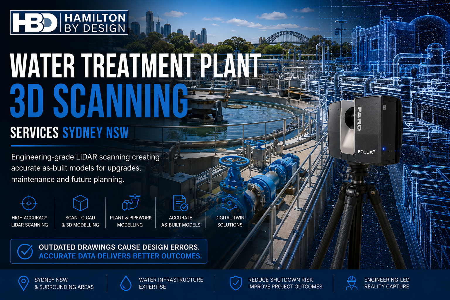
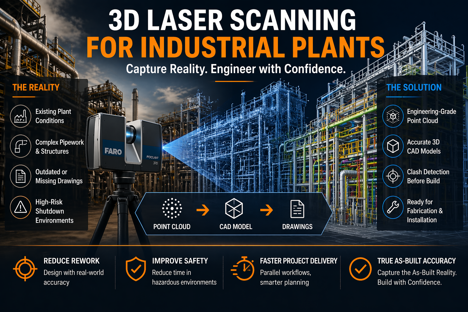
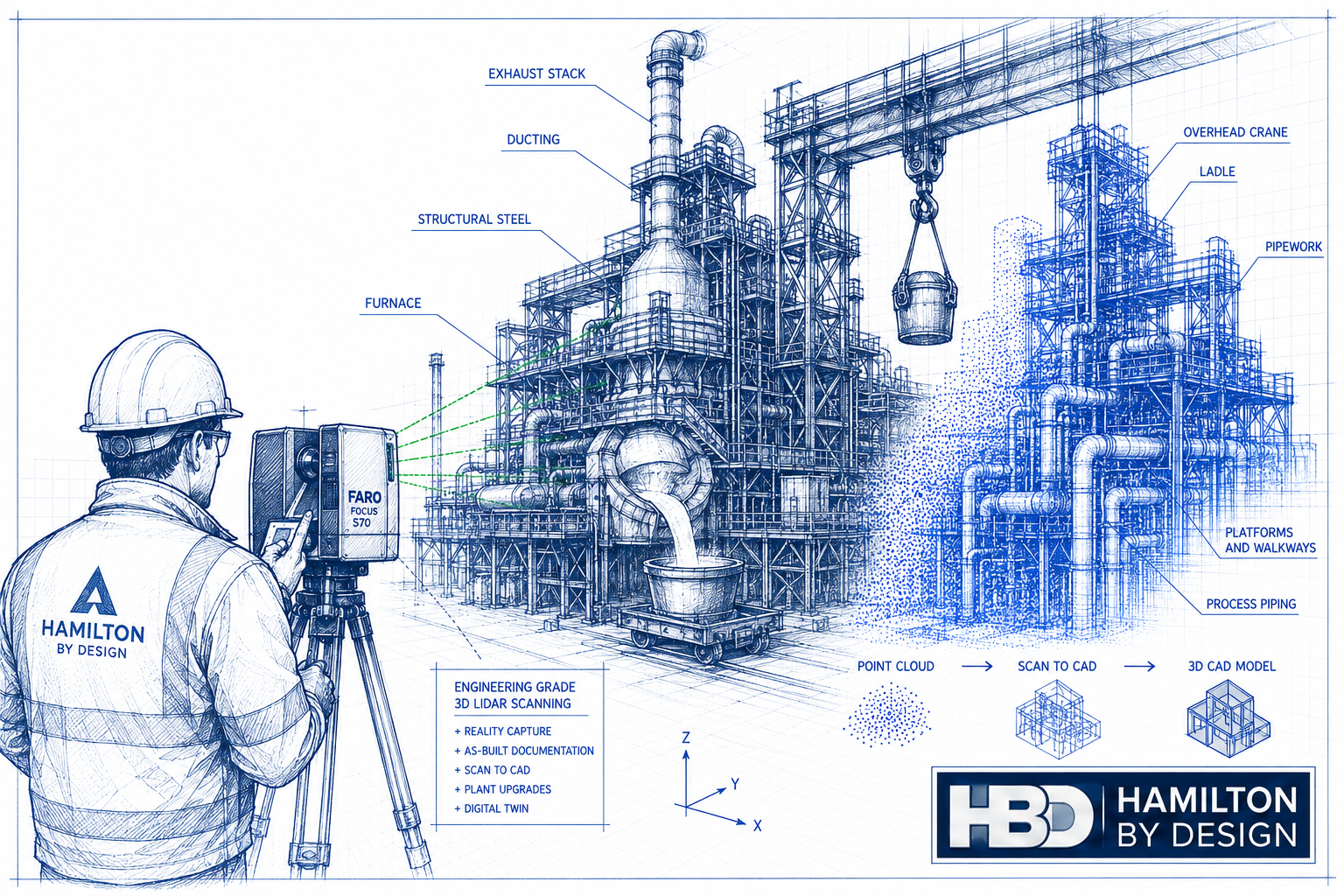
Hamilton By Design provides Smelter 3D LiDAR Scanning Services in Newcastle NSW, delivering engineering-grade reality capture that allows project teams to work from accurate as-built information rather than outdated drawings. Using our 3D Laser Scanning Services, we capture millions of measurements across existing facilities and convert this information into engineering-ready point clouds, CAD models and digital as-built documentation.
Whether your project involves a shutdown, brownfield expansion, equipment replacement or complete plant upgrade, accurate site data is the foundation of successful engineering.
Why Existing Drawings Become Unreliable
Few industrial facilities remain unchanged over their operating life.
Most smelters have experienced numerous modifications, including:
- New process equipment
- Replacement pipework
- Conveyor upgrades
- Structural strengthening
- Additional platforms and access ways
- New services and cable trays
- Dust extraction modifications
- Pump replacements
- Instrumentation upgrades
- Temporary repairs that became permanent installations
While individual projects may have produced updated drawings, complete documentation is rarely maintained over several decades.
As a result, engineering teams frequently discover discrepancies only after arriving on site or during construction. These unexpected differences often lead to redesign, fabrication changes, additional site work and costly project delays.
Hamilton By Design helps eliminate this uncertainty by capturing the plant exactly as it exists today.
Engineering-Grade 3D LiDAR Scanning
Unlike traditional site measuring, terrestrial LiDAR scanning captures millions of highly accurate measurements in every scan position.
Our engineering workflow records:
- Structural steel
- Pipework
- Tanks
- Pressure vessels
- Pumps
- Valves
- Conveyors
- Chutes
- Platforms
- Walkways
- Stairs
- Handrails
- Cable trays
- Mechanical equipment
- Existing foundations
- Process buildings
This comprehensive digital record becomes the foundation for future engineering, drafting and asset management activities.
Once captured, the point cloud can be transformed into intelligent engineering models using our Scan to CAD Services, allowing designers to work efficiently from accurate digital information.
Reduce Brownfield Engineering Risk
Brownfield projects present unique engineering challenges because new equipment must integrate into an existing operating plant.
Typical risks include:
- Unknown clearances
- Hidden structural members
- Pipe routing conflicts
- Maintenance access restrictions
- Interference with electrical services
- Equipment clashes
- Incorrect foundation locations
Without accurate site information, engineers are forced to make assumptions.
These assumptions often become expensive construction variations.
Hamilton By Design captures the existing plant with engineering-grade accuracy, allowing designers to verify every interface before fabrication begins. Our Brownfield Engineering Services help clients confidently integrate new equipment into existing facilities while reducing construction risk.
Support Shutdown Planning
Shutdown windows are expensive.
Every additional hour impacts production and increases contractor costs.
Accurate LiDAR scanning allows engineering teams to complete much of the design work before the shutdown begins.
Instead of relying on multiple site visits, designers work directly from the captured point cloud to develop:
- Mechanical layouts
- Structural modifications
- Pipe routing
- Equipment positioning
- Maintenance access reviews
- Installation sequencing
By reducing uncertainty during the design phase, shutdown activities become faster, safer and more predictable.
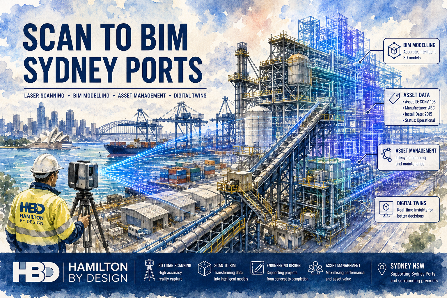
Accurate As-Built Documentation
One of the greatest long-term benefits of LiDAR scanning is the creation of accurate as-built documentation.
Hamilton By Design can provide:
- Registered point clouds
- AutoCAD drawings
- 3D CAD models
- SolidWorks assemblies
- Autodesk Inventor models
- STEP models
- Navisworks coordination models
- Structural steel models
- Equipment models
- General arrangement drawings
- Engineering verification models
These deliverables provide a reliable engineering record that can be reused for future projects, maintenance planning and asset management.
Improve Design Accuracy
Engineering design is only as accurate as the information used to create it.
By working from an accurate point cloud, engineers can confidently design:
- Replacement conveyors
- Pipework systems
- Pump installations
- Structural platforms
- Maintenance access systems
- Mechanical upgrades
- Process equipment
- Tank modifications
- Support steel
- Ducting systems
This greatly reduces the need for redesign during construction.
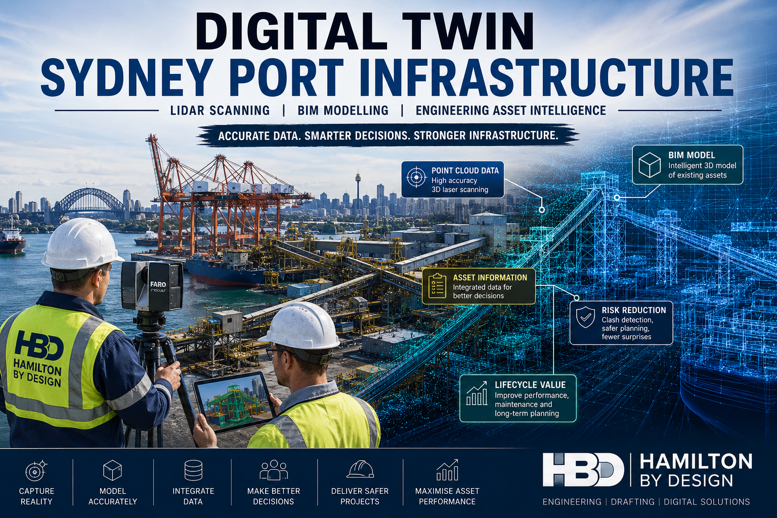
Digital Twins for Smelter Facilities
Many industrial operators are now investing in digital engineering workflows.
A high-quality LiDAR scan forms the basis of a digital twin by accurately representing the current physical condition of the facility.
A digital twin can support:
- Asset management
- Future expansions
- Shutdown planning
- Maintenance strategies
- Engineering studies
- Safety assessments
- Training
- Plant familiarisation
Instead of relying on incomplete drawings, engineers have access to a complete digital representation of the plant.
Typical Areas We Scan
Hamilton By Design provides LiDAR scanning throughout industrial smelter facilities, including:
- Ore handling systems
- Crushing areas
- Conveyors
- Transfer towers
- Smelting furnace buildings
- Casting facilities
- Refining areas
- Pipe racks
- Cooling water systems
- Structural steel
- Dust extraction systems
- Process pipework
- Pump stations
- Tank farms
- Workshops
- Compressor rooms
- Electrical substations
- Cable tray systems
- Access platforms
- Walkways
- Stair systems
Our approach ensures all critical engineering interfaces are captured for future design work.
Engineering-Led Scan-to-CAD Services
Hamilton By Design is more than a scanning provider.
As a mechanical engineering consultancy, we understand how captured data will be used during design, drafting and construction.
Our services include:
- Engineering drafting
- Mechanical design
- Structural steel detailing
- Scan-to-CAD conversion
- Reverse engineering
- Plant layout development
- As-built verification
- Brownfield engineering support
- 3D modelling
- Engineering documentation
Because scanning and engineering are delivered together, the final outputs are tailored to the needs of designers, fabricators and asset owners.
If replacement components need to be recreated where original OEM drawings no longer exist, our Reverse Engineering Services provide accurate engineering models developed directly from LiDAR scan data.
For clients requiring complete engineering support beyond scanning, our Mechanical Engineering Services deliver practical solutions from concept design through to detailed drafting and fabrication documentation.
Why Newcastle NSW?
Newcastle has a long history of heavy industry, steel manufacturing, minerals processing and industrial engineering. Many facilities have evolved through decades of operational improvements, making accurate engineering documentation increasingly important.
LiDAR scanning provides a practical solution for organisations managing ageing infrastructure by creating a reliable digital record of current plant conditions.
Whether the project involves equipment replacement, structural modifications, shutdown planning or long-term asset management, engineering teams benefit from working with accurate, up-to-date information rather than relying on historical drawings.
Why Choose Hamilton By Design?
Hamilton By Design combines advanced terrestrial LiDAR scanning technology with practical engineering experience.
Our clients value our ability to deliver:
- Engineering-grade LiDAR scanning
- Accurate as-built documentation
- Brownfield engineering support
- Scan-to-CAD modelling
- Mechanical engineering expertise
- Structural modelling
- Reverse engineering
- Shutdown planning assistance
- High-quality engineering documentation
We understand the demands of operating industrial facilities and the importance of delivering information that engineers can confidently use for design, fabrication and construction.

Ready to Modernise Your Smelter Documentation?
If your smelter drawings no longer reflect the current plant, now is the time to create an accurate digital record.
Hamilton By Design provides Smelter 3D LiDAR Scanning Services in Newcastle NSW, helping industrial operators reduce brownfield engineering risk, improve shutdown planning and develop reliable as-built documentation for future projects.
Whether you require a single process area, a complete facility scan or ongoing engineering support, our team can deliver engineering-grade reality capture tailored to your project requirements.
Contact Hamilton By Design today to discuss your next smelter upgrade, shutdown or brownfield engineering project and discover how engineering-grade LiDAR scanning can reduce project risk while improving design accuracy.
Talk to Us – Contact Us
Our clients: