Scan to BIM Sydney

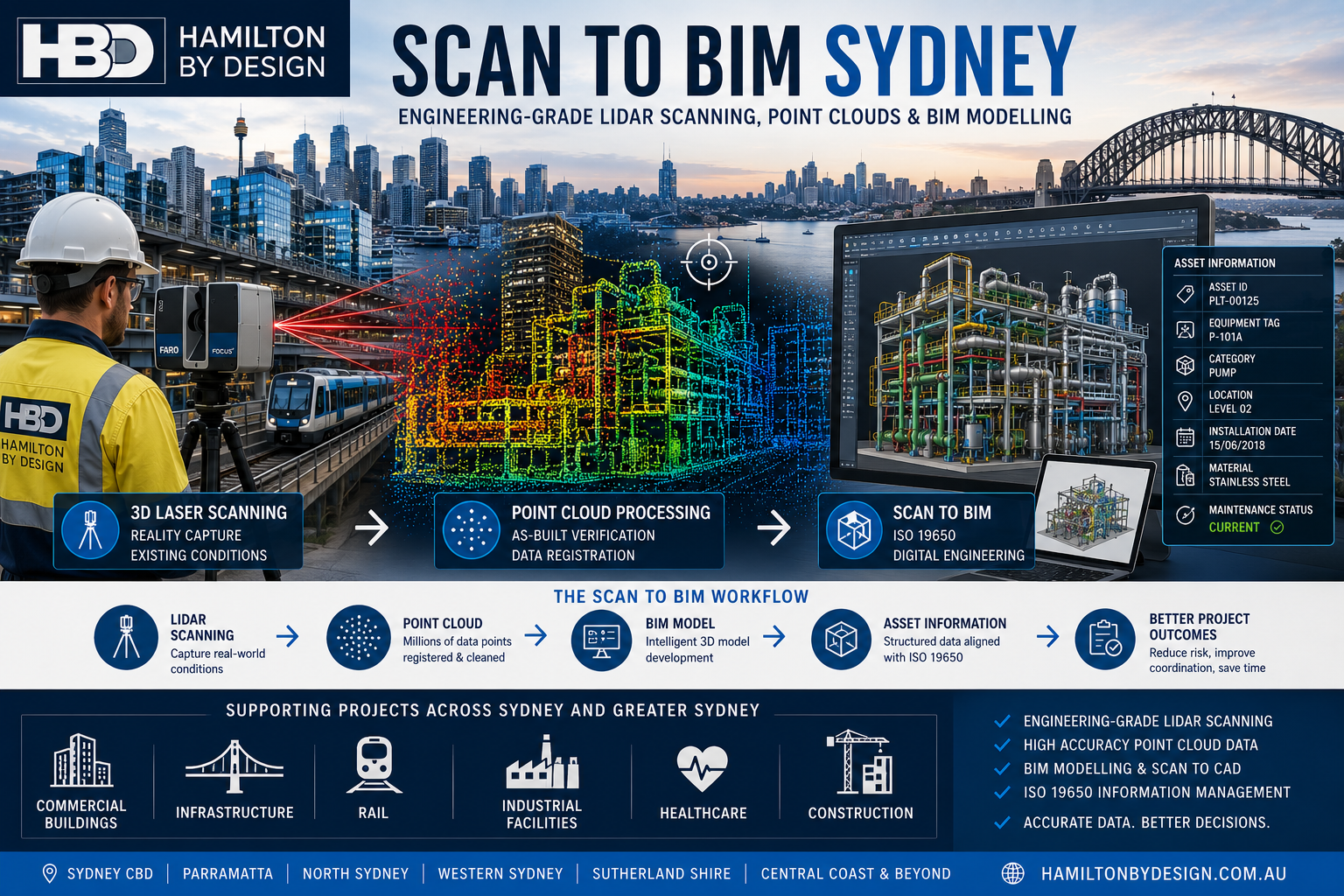
Scan to BIM Sydney infographic showing LiDAR laser scanning, point cloud processing and BIM modelling workflow for Sydney commercial, infrastructure and industrial projects using ISO 19650 information management principles.

Engineering-Grade Reality Capture and BIM Modelling

Sydney is Australia’s largest construction, infrastructure and commercial property market. From high-rise developments and transport infrastructure to hospitals, industrial facilities and heritage buildings, project teams increasingly rely on accurate digital information to reduce risk and improve project outcomes.

Scan to BIM Sydney combines advanced 3D laser scanning, LiDAR technology and Building Information Modelling (BIM) to create accurate digital representations of existing assets. The result is a reliable foundation for design, construction, maintenance and asset management decisions.

At Hamilton By Design, Scan to BIM is delivered from an engineering perspective, ensuring that models are developed to support real project requirements rather than simply producing visual geometry.


What is Scan to BIM?

Scan to BIM is the process of capturing existing conditions using high-accuracy laser scanning equipment and converting the resulting point cloud data into intelligent BIM models.

The process typically includes:

  • 3D Laser Scanning and LiDAR Capture
  • Point Cloud Registration
  • Existing Condition Surveys
  • Scan to CAD Conversion
  • BIM Model Development
  • As-Built Verification
  • Asset Information Management
  • Design Coordination and Clash Detection

The final BIM model provides a detailed and measurable representation of the real-world asset.


Why Sydney Projects Use Scan to BIM

Many Sydney assets have undergone multiple modifications over decades. Original drawings are often incomplete, outdated or unavailable.

Scan to BIM helps project teams overcome these challenges by providing:

Improved Accuracy

Laser scanning captures millions of measurements in a matter of minutes, creating an accurate record of existing conditions.

Reduced Project Risk

Accurate as-built information reduces design assumptions and minimises costly rework during construction.

Better Coordination

Architects, engineers, contractors and asset owners can work from a common source of information.

Faster Project Delivery

Reliable digital data allows design teams to progress more efficiently and with greater confidence.

Enhanced Safety

Understanding existing conditions before commencing work helps identify potential hazards and access constraints.


Applications of Scan to BIM in Sydney

Hamilton By Design supports a wide range of industries and project types across Sydney and Greater Sydney.

Commercial Buildings

  • Office towers
  • Shopping centres
  • Mixed-use developments
  • Building refurbishments
  • Property management

Infrastructure

  • Rail facilities
  • Transport interchanges
  • Utility assets
  • Water treatment facilities
  • Public infrastructure projects

Industrial Facilities

  • Manufacturing plants
  • Warehouses
  • Processing facilities
  • Bulk materials handling systems
  • Distribution centres

Healthcare and Education

  • Hospitals
  • Medical centres
  • Universities
  • Schools
  • Research facilities

Heritage Buildings

Laser scanning provides a non-contact method of accurately documenting complex heritage structures while preserving historical integrity.


Engineering-Led Scan to BIM

A successful Scan to BIM project requires more than simply converting a point cloud into a model.

Engineering considerations include:

  • Required level of detail (LOD)
  • Asset criticality
  • Intended use of the model
  • Data accuracy requirements
  • Information classification
  • Future maintenance requirements

Hamilton By Design applies engineering knowledge throughout the process to ensure the final BIM model supports operational and project objectives.


Scan to BIM and ISO 19650

Modern BIM projects increasingly require structured information management.

The international standard ISO 19650 provides a framework for managing information throughout the asset lifecycle.

By aligning Scan to BIM workflows with ISO 19650 principles, organisations can improve:

  • Information quality
  • Document control
  • Asset data consistency
  • Collaboration between stakeholders
  • Long-term asset management outcomes

For further information, read:

๐Ÿ‘‰ ISO 19650, Scan to BIM and Information Management


Academic Perspective on Scan to BIM

While Scan to BIM offers significant benefits, organisations should also understand its limitations, implementation challenges and future development pathways.

For a detailed academic discussion, including the advantages, disadvantages and future direction of Scan to BIM technologies, refer to:

๐Ÿ‘‰ Scan to BIM Academic Review


Typical Scan to BIM Workflow

1. Site Capture

High-accuracy LiDAR scanning is performed across the project area.

2. Point Cloud Processing

Individual scans are registered into a unified point cloud dataset.

3. Data Review

The point cloud is reviewed and validated against project requirements.

4. BIM Development

The point cloud is converted into BIM geometry and asset information.

5. Quality Assurance

Models are checked against project specifications and accuracy requirements.

6. Information Delivery

The final BIM deliverables are provided for design, construction or asset management use.


Scan to BIM Sydney Services

Hamilton By Design supports projects throughout:

  • Sydney CBD
  • Western Sydney
  • Parramatta
  • Liverpool
  • Penrith
  • North Sydney
  • Chatswood
  • Macquarie Park
  • Sutherland Shire
  • Newcastle and Hunter Region
  • Central Coast

Services include:

  • Engineering-Grade LiDAR Scanning
  • Scan to BIM
  • Scan to CAD
  • Point Cloud Processing
  • As-Built Modelling
  • Structural Modelling
  • Mechanical Plant Modelling
  • Asset Information Capture
  • Digital Engineering Support

Why Choose Hamilton By Design?

Hamilton By Design combines practical engineering experience with advanced reality capture technology.

Our approach focuses on delivering information that can be used by engineers, project managers, contractors and asset owners to make better decisions throughout the asset lifecycle.

Whether supporting a commercial building upgrade, industrial facility expansion, transport infrastructure project or digital asset management initiative, our Scan to BIM services provide a reliable foundation for project success.


Hamilton By Design logo displayed on a blue tilted rectangle with a grey gradient background

Contact Hamilton By Design


Looking for Scan to BIM Sydney services?

Hamilton By Design provides engineering-grade LiDAR scanning, point cloud processing, Scan to CAD and BIM modelling services across Sydney, Greater Sydney and regional New South Wales.

Accurate Data. Better Design. Safer Construction. Smarter Asset Management.

Name
Would you like us to arrange a phone consultation for you?
Address

Academic Review

Australian Drafting logo featuring bold white text reading "Australian Drafting" centred on a blue rounded rectangle background.
Engineering Governance title graphic featuring bold white text reading "Engineering Governance" centred on a blue rounded rectangle background.
Mechanical, Structural & Pipework Drafting service banner by Hamilton By Design featuring white text on a blue background.
Mechanical engineering services
Blue rounded button with the text โ€œSolidWorks Designโ€ in white.
Finite Element Analysis (FEA) engineering simulation button
3D LiDAR Scanning Darwin for engineering surveys, laser scanning, reality capture and point cloud modelling services
3D LiDAR Scanning Australia engineering services for laser scanning, reality capture, scan-to-CAD, Scan-to-BIM and as-built documentation across Australia
3D LiDAR scanning services on the Central Coast providing engineering-grade laser scanning, point cloud capture, scan-to-CAD modelling and industrial reality capture for infrastructure and industrial projects.
3D LiDAR Scanning Perth for engineering surveys, laser scanning, reality capture and point cloud modelling services
3D LiDAR Scanning Sydney for engineering surveys, laser scanning, reality capture and point cloud modelling services
3D LiDAR Scanning Brisbane for engineering surveys, laser scanning, reality capture and point cloud modelling services
3D LiDAR Scanning Canberra for engineering surveys, laser scanning, reality capture and point cloud modelling services
3D LiDAR Scanning Newcastle for engineering surveys, laser scanning, reality capture and point cloud modelling services
3D LiDAR Scanning Adelaide for engineering surveys, laser scanning, reality capture and point cloud modelling services
3D LiDAR Scanning Darwin for engineering surveys, laser scanning, reality capture and point cloud modelling services
3D LiDAR Scanning Australia engineering services for laser scanning, reality capture, scan-to-CAD, Scan-to-BIM and as-built documentation across Australia
3D LiDAR scanning services on the Central Coast providing engineering-grade laser scanning, point cloud capture, scan-to-CAD modelling and industrial reality capture for infrastructure and industrial projects.

Scan to CAD Perth

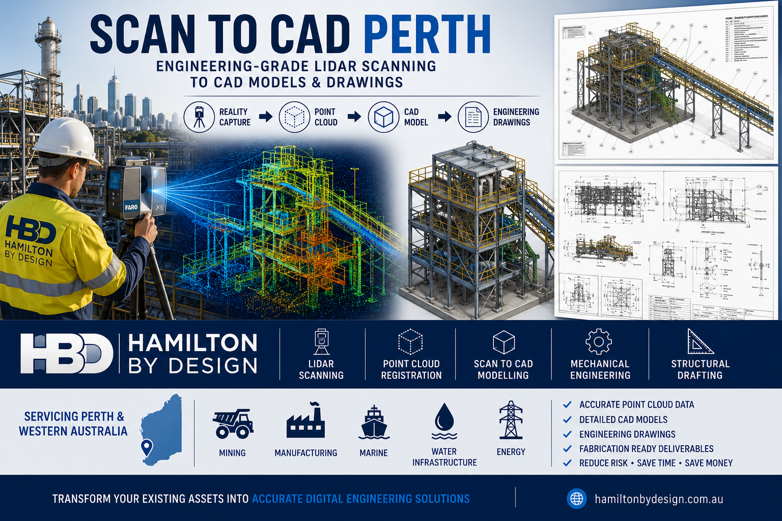
Scan to CAD Perth workflow by Hamilton By Design showing engineering-grade LiDAR scanning of an industrial processing facility in Perth, Western Australia. The image illustrates the complete reality capture process from laser scanning and point cloud registration through to 3D CAD modelling, engineering drawings, mechanical engineering and structural drafting. Featured are a field engineer operating a FARO laser scanner, a coloured point cloud model, a detailed industrial plant CAD model, fabrication drawings and industries including mining, manufacturing, marine, water infrastructure and energy.

Engineering-Grade Point Cloud to CAD Services

Scan to CAD Perth

Blue 3D LiDAR scanner icon on a tripod with scanning waves

When existing facilities, equipment, structures, and process plants need to be modified, expanded, or documented, accurate information is critical. Unfortunately, many sites across Perth and Western Australia rely on outdated drawings, incomplete documentation, or site measurements that do not reflect what has actually been built.

Hamilton By Design provides professional Scan to CAD Perth services, combining engineering-grade LiDAR scanning with experienced mechanical and structural drafting to create accurate CAD models and drawings from real-world assets.

Rather than relying on tape measures or assumptions, we capture the existing environment using advanced 3D laser scanning technology and convert the resulting point cloud data into usable engineering deliverables.


What is Scan to CAD?

Scan to CAD is the process of converting physical assets into accurate digital engineering models and drawings.

The workflow typically includes:

  1. Site scanning using LiDAR technology
  2. Registration of the point cloud data
  3. Creation of CAD models
  4. Production of engineering drawings
  5. Verification against captured site conditions

The result is a highly accurate digital representation of the existing asset that can be used for engineering, maintenance, fabrication, and future upgrades.


Why Use Scan to CAD?

Many projects fail because existing site information is incorrect.

Common challenges include:

  • Missing drawings
  • Outdated drawings
  • Unrecorded modifications
  • Unknown equipment locations
  • Limited shutdown windows
  • Expensive site revisits
  • Fabrication errors
  • Installation clashes

Scan to CAD helps eliminate these issues by providing a reliable digital record of the actual site conditions.


Our Scan to CAD Workflow

1. Site Capture

Hamilton By Design uses engineering-grade LiDAR scanning equipment to capture millions of measurement points across the site.

Applications include:

  • Mining facilities
  • Processing plants
  • Structural steel installations
  • Pipework systems
  • Conveyor systems
  • Water treatment facilities
  • Manufacturing plants
  • Marine facilities

2. Point Cloud Registration

Individual scans are combined into a single registered dataset.

This process creates a coordinated point cloud representing the complete facility.

Deliverable formats can include:

  • E57
  • RCP
  • RCS
  • LAS

3. CAD Modelling

The point cloud is imported into engineering software where accurate models are developed.

Software used includes:

  • SOLIDWORKS
  • AutoCAD
  • Autodesk Inventor
  • Navisworks

Models may include:

  • Structural steel
  • Pipework
  • Mechanical equipment
  • Platforms and access systems
  • Buildings and facilities
  • Process infrastructure

4. Engineering Drawings

Once modelling is complete, the information can be converted into detailed engineering documentation.

Typical deliverables include:

  • General Arrangement Drawings
  • Fabrication Drawings
  • As-Built Drawings
  • Layout Drawings
  • Structural Steel Drawings
  • Mechanical Drawings
  • Pipework Drawings

Industries We Support in Perth

Hamilton By Design supports clients throughout Perth and Western Australia including:

Mining

  • Iron Ore
  • Gold
  • Lithium
  • Nickel
  • Mineral Processing

Manufacturing

  • Food Processing
  • Packaging Facilities
  • Industrial Production

Energy

  • Power Generation
  • Renewable Energy Facilities
  • Oil and Gas Infrastructure

Water Infrastructure

  • Water Treatment Plants
  • Pump Stations
  • Wastewater Facilities

Marine and Ports

  • Ship Repair Facilities
  • Port Infrastructure
  • Bulk Handling Equipment

Benefits of Scan to CAD

Reduce Site Visits

Capture everything during a single visit and continue working remotely.

Improve Design Accuracy

Design directly from measured site conditions.

Reduce Fabrication Risk

Accurate models help reduce costly fabrication errors.

Improve Safety

Less time measuring equipment in operational environments.

Support Future Projects

Create a digital record that can be reused for future upgrades.


Typical Scan to CAD Deliverables

Hamilton By Design can provide:

  • Point Cloud Files
  • AutoCAD Drawings
  • SOLIDWORKS Models
  • Inventor Models
  • STEP Files
  • SAT Files
  • DWG Files
  • DXF Files
  • Structural Steel Models
  • Mechanical Equipment Models
  • Pipework Models
  • Fabrication Drawings

Why Hamilton By Design?

Hamilton By Design combines reality capture technology with practical engineering experience.

Our team understands:

  • Mechanical Engineering
  • Structural Steel Design
  • Fabrication Workflows
  • Mining Infrastructure
  • Process Plants
  • Site Installation Requirements

This means we do more than simply collect scan data. We transform site information into practical engineering deliverables that support project execution.


Perth Service Area

We provide Scan to CAD services across:

  • Perth CBD
  • Kwinana
  • Henderson
  • Welshpool
  • Canning Vale
  • Malaga
  • Osborne Park
  • Rockingham
  • Fremantle
  • Bunbury
  • Geraldton
  • Kalgoorlie
  • Port Hedland
  • Karratha
  • Pilbara Region

  • 3D Laser Scanning Perth
  • LiDAR Scanning Perth
  • Mechanical Engineering Perth
  • Reverse Engineering Perth
  • Structural Drafting Perth
  • Point Cloud to CAD Modelling
  • As-Built Documentation
  • Industrial Reality Capture

Frequently Asked Questions

What is Scan to CAD?

Scan to CAD is the process of converting laser scan data into CAD models and engineering drawings.

What industries use Scan to CAD?

Mining, manufacturing, energy, water, marine, construction, and industrial facilities commonly use Scan to CAD workflows.

What file formats can be delivered?

DWG, DXF, STEP, SAT, Parasolid, E57, RCP, RCS, and PDF.

Can Scan to CAD be used for structural steel?

Yes. Existing structures can be scanned and converted into detailed structural steel models and fabrication drawings.

Can Scan to CAD be used for pipework?

Yes. Pipework systems can be modelled directly from point cloud data to support modifications and upgrades.

Do you provide services outside Perth?

Yes. Hamilton By Design supports projects throughout Western Australia and across Australia.


Our Clients


Contact Hamilton By Design

If you require accurate site information for design, fabrication, maintenance, or asset management, Hamilton By Design can help.

Our engineering-led Scan to CAD Perth services transform real-world assets into accurate digital engineering deliverables, helping projects move forward with confidence.

Hamilton By Design โ€“ Engineering, LiDAR Scanning, CAD Modelling and Drafting Services Across Perth and Western Australia.

Hamilton By Design logo displayed on a blue tilted rectangle with a grey gradient background
Name
Would you like us to arrange a phone consultation for you?
Address

Where are we in Perth

https://www.hamiltonbydesign.com.au/perth-wa
3D CAD Modelling Australia service banner for Hamilton By Design
Australian Drafting logo featuring bold white text reading "Australian Drafting" centred on a blue rounded rectangle background.
Engineering Governance title graphic featuring bold white text reading "Engineering Governance" centred on a blue rounded rectangle background.
Mechanical, Structural & Pipework Drafting service banner by Hamilton By Design featuring white text on a blue background.
Mechanical engineering services
Blue rounded button with the text โ€œSolidWorks Designโ€ in white.
Finite Element Analysis (FEA) engineering simulation button
3D LiDAR Scanning Darwin for engineering surveys, laser scanning, reality capture and point cloud modelling services
3D LiDAR Scanning Australia engineering services for laser scanning, reality capture, scan-to-CAD, Scan-to-BIM and as-built documentation across Australia
3D LiDAR scanning services on the Central Coast providing engineering-grade laser scanning, point cloud capture, scan-to-CAD modelling and industrial reality capture for infrastructure and industrial projects.
3D LiDAR Scanning Perth for engineering surveys, laser scanning, reality capture and point cloud modelling services
3D LiDAR Scanning Sydney for engineering surveys, laser scanning, reality capture and point cloud modelling services
3D LiDAR Scanning Brisbane for engineering surveys, laser scanning, reality capture and point cloud modelling services
3D LiDAR Scanning Canberra for engineering surveys, laser scanning, reality capture and point cloud modelling services
3D LiDAR Scanning Newcastle for engineering surveys, laser scanning, reality capture and point cloud modelling services
3D LiDAR Scanning Adelaide for engineering surveys, laser scanning, reality capture and point cloud modelling services

Engineering-Grade LiDAR Scanning vs Scan-as-You-Walk Systems

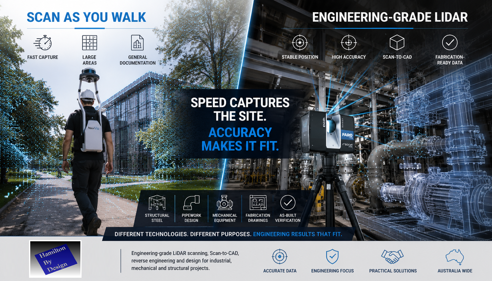
Split-screen comparison of mobile LiDAR scanning and engineering-grade terrestrial laser scanning. The left side shows a wearable scan-as-you-walk LiDAR system capturing a large outdoor environment, while the right side shows a tripod-mounted laser scanner capturing structural steel, pipework and mechanical equipment in an industrial facility. The image highlights the message: "Speed Captures the Site. Accuracy Makes It Fit."

Why Scanner Stability Matters When Accuracy Matters

LiDAR stands for Light Detection and Ranging. It uses laser light to measure distance and create a 3D digital representation of the real world.

But in engineering, the distance measurement is only part of the story.

To produce reliable design, drafting and fabrication data, the scanner also needs to know exactly where it was positioned, how it was orientated, and how every measurement relates to the rest of the site.

That is why stable, engineering-grade scanning matters.


Scan as You Walk Has Its Place

Walk-through LiDAR systems such as NavVis-style mobile scanners are impressive technologies. They allow an operator to move through an environment while capturing large volumes of spatial data quickly.

For some applications, this is a major advantage.

Scan-as-you-walk systems can be useful for:

  • Facility documentation
  • Asset walkthroughs
  • Digital tours
  • Large building capture
  • Universities
  • Shopping centres
  • Hospitals
  • National parks
  • General spatial records

If the objective is to document a large area quickly, mobile scanning can be a practical solution.

But speed is not the same as engineering certainty.


Engineering Accuracy Requires More Than Walking Through a Site

When a scanner is moving, the system must continuously calculate:

  • where the scanner is located
  • which direction it is facing
  • how fast it is moving
  • how it is rotating
  • how each scan position connects to the next

This is normally achieved using SLAM, cameras, IMUs and software-based positioning.

These systems are powerful, but they can still be affected by drift, movement, poor geometry, reflective surfaces, repetitive structures and weak reference points.

In engineering, small errors can become expensive problems.

A point cloud may look good on screen, but that does not always mean it is suitable for mechanical design, structural detailing or fabrication.


Why Hamilton By Design Uses FARO Focus Technology

At Hamilton By Design, we use FARO Focus terrestrial laser scanning for engineering-grade reality capture.

The FARO Focus scanner is set up on a stable tripod position. It captures high-density scan data from fixed locations, allowing the point cloud to be registered, checked and used for design work with confidence.

This approach is slower than simply walking through a site, but it provides the quality of data required for engineering deliverables.

We use FARO scanning for:

  • Scan-to-CAD
  • Reverse engineering
  • Mechanical design
  • Structural steel modelling
  • Pipework layouts
  • Fabrication drawings
  • As-built documentation
  • Clash detection
  • Plant room scanning
  • Industrial site verification
  • Shutdown planning

When structural steel needs to fit, pipework needs to align and fabricated components need to be manufactured from the captured data, accuracy matters.


The Difference Is the Final Outcome

A walk-through scan may be suitable when the purpose is general documentation.

A FARO Focus scan is more suitable when the data will be used to design, manufacture, install or verify engineered components.

That difference matters.

If the objective is to walk through a national park, a mobile scanner may be the right tool.

If the objective is to make sure structural beams, pipe spools, platforms, chutes, hoppers or mechanical components fit together correctly, then engineering-grade LiDAR scanning is the safer choice.

Because when the fabrication team arrives on site, the steel either fits or it does not.


Real-World Engineering Experience

Hamilton By Design is often asked to revisit sites where previous scan data was not suitable for engineering use.

In recent weeks, we have been requested multiple times to rescan building and industrial sites after earlier walk-through scanning did not provide the level of accuracy or detail required for design and drafting.

This does not mean mobile scanning is wrong.

It means the scanning method must match the intended use.

For general site capture, speed may be the priority.

For engineering, fabrication and installation, accuracy must come first.


LiDAR Measures Distance. Engineering Requires Position Certainty.

LiDAR uses light to measure distance.

However, engineering-grade point clouds require more than distance. They require confidence in the scanner position, orientation, registration and final geometry.

A simple way to explain it is this:

A tape measure may be accurate, but if you do not know exactly where the measurement started, the result can still be wrong.

The same applies to LiDAR scanning.

The laser may measure accurately, but if the scanner position is uncertain, the final point cloud may not be suitable for engineering work.


Where FARO Focus Scanning Adds Value

Hamilton By Design provides engineering-led LiDAR scanning for clients who need usable design data, not just a visual point cloud.

Our scanning and modelling services support:

  • Industrial plants
  • Mechanical rooms
  • Processing facilities
  • Mining infrastructure
  • Conveyor systems
  • Structural platforms
  • Pipework and services
  • Equipment layouts
  • Existing buildings
  • Brownfield modification projects

We do not just scan the site.

We understand how the scan data will be used in design, drafting, fabrication and installation.

That engineering understanding is what makes the difference.


Engineering-Grade Deliverables

Depending on the project requirements, Hamilton By Design can provide:

  • Registered point clouds
  • E57 files
  • RCP / RCS files
  • Scan-to-CAD models
  • AutoCAD drawings
  • SolidWorks models
  • Inventor models
  • STEP / SAT / Parasolid files
  • General arrangement drawings
  • Sections and elevations
  • Fabrication drawings
  • As-built verification models

Our focus is to provide practical engineering information that can be used by designers, fabricators, builders, installers and asset owners.


Choose the Right Scanner for the Right Job

Scan-as-you-walk systems are fast and useful for many documentation tasks.

FARO Focus scanning is better suited to engineering-grade work where accuracy, registration and point cloud quality are critical.

At Hamilton By Design, we believe the technology should be selected based on the outcome required.

If you need to document a large space quickly, mobile scanning may be suitable.

If you need structural steel, pipework or mechanical components to fit together first time, FARO Focus scanning is hard to go past.


Hamilton By Design โ€“ Engineering-Led LiDAR Scanning

Hamilton By Design provides engineering-grade LiDAR scanning, Scan-to-CAD, reverse engineering, mechanical drafting and structural design support across Australia.

We combine reality capture with practical engineering experience to help clients move from existing site conditions to accurate design and fabrication deliverables.

For industrial, mechanical and structural projects, the question is not just how fast the site can be scanned.

The real question is:

Can the scan data be trusted when it is time to design, fabricate and install?

That is where engineering-grade LiDAR scanning matters.

3D LiDAR scanning and 3D modelling services button
Mechanical engineering services
Building and construction services button
Hamilton By Design logo displayed on a blue tilted rectangle with a grey gradient background

Would you like to know more ?

Contact Us – Talk to Us

Name
Would you like us to arrange a phone consultation for you?
Address

Our Clients

3D LiDAR scanning and 3D modelling service button โ€” laser scanner capturing a point cloud for engineering and CAD modelling
Mechanical engineering services

3D Scanning Sydney banner promoting engineering-grade 3D laser scanning, LiDAR scanning, and reality capture services by Hamilton By Design.
Mechanical Engineering Sydney banner with white text on a blue background representing Hamilton By Design's mechanical engineering services in Sydney.
Mechanical Drafting and 3D Modelling Sydney banner highlighting Hamilton By Design's CAD drafting, 3D modelling, and engineering design services in Sydney.
Blue banner graphic displaying the text "Point Cloud to CAD - Australia" in large white lettering, representing point cloud processing, scan-to-CAD conversion and digital engineering services across Australia.
Blue banner graphic displaying the text "Scan to CAD Sydney" in large white lettering, representing engineering-led point cloud to CAD conversion, LiDAR scanning and digital engineering services in Sydney.
Blue banner graphic displaying the text "Reality Capture Sydney - CBD" in large white lettering, representing engineering-led reality capture, LiDAR scanning and digital engineering services within Sydney CBD commercial buildings and infrastructure.

LiDAR Scanning Greater Brisbane | Engineering Grade Reality Capture & Scan to CAD

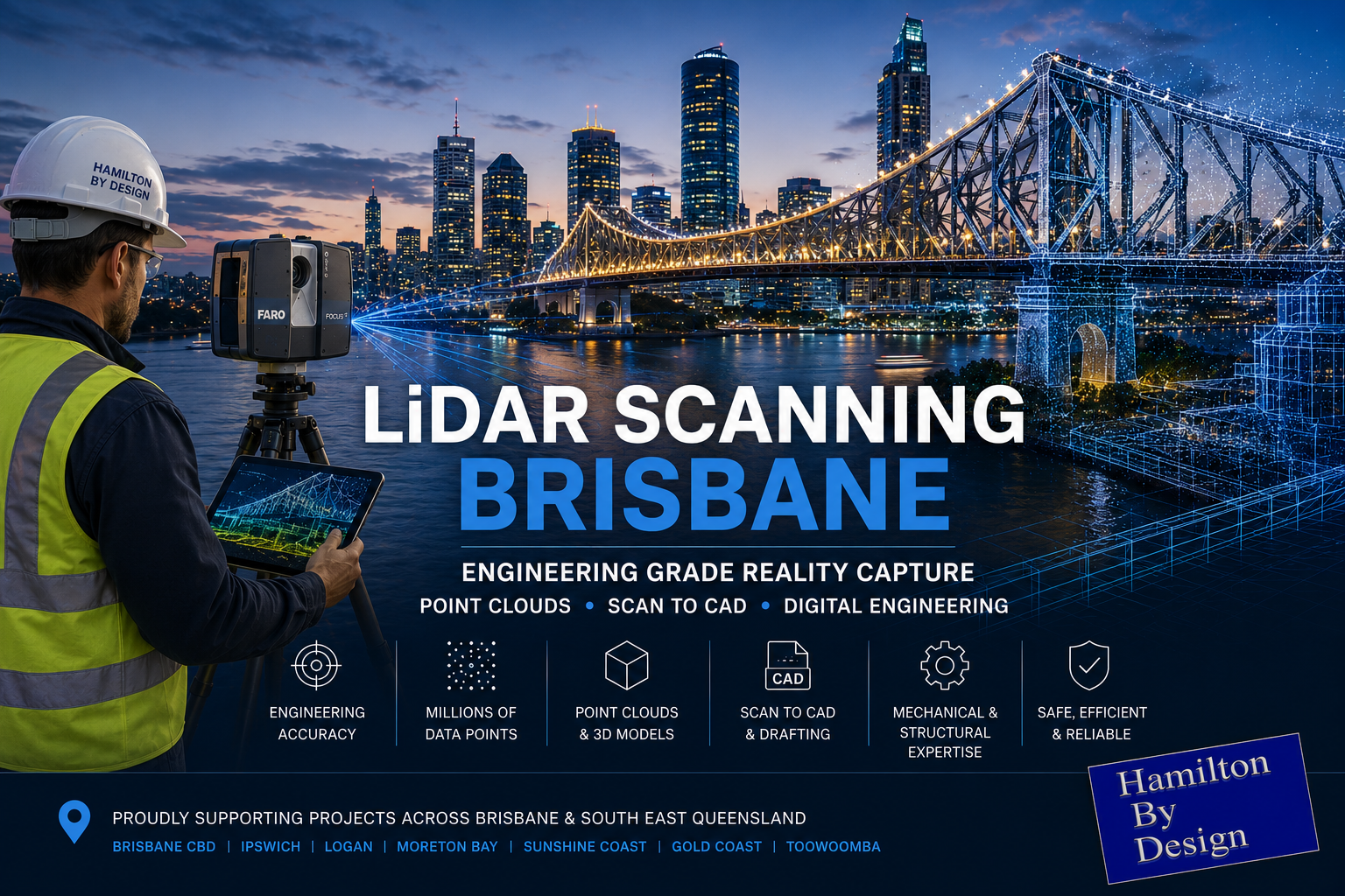
Engineering-grade LiDAR scanning in Brisbane featuring the Story Bridge, Brisbane River and CBD skyline with a terrestrial laser scanner capturing point cloud data for reality capture, Scan to CAD and digital engineering services.

LiDAR Scanning Greater Brisbane โ€“ Engineering Grade Reality Capture, Point Clouds & Scan to CAD Services

Engineering-Led LiDAR Scanning Services Across Greater Brisbane and Southeast Queensland

Blue 3D LiDAR scanner icon on a tripod with scanning waves

Hamilton By Design provides engineering-grade LiDAR scanning Brisbane services for industrial facilities, mining operations, manufacturing plants, infrastructure projects, commercial buildings and complex engineering environments throughout Brisbane and Southeast Queensland.

Unlike many surveying and scanning providers, our team combines practical site experience, mechanical engineering knowledge, drafting expertise and advanced reality capture technology to deliver accurate digital representations of existing assets. This allows clients to confidently plan upgrades, shutdowns, modifications, maintenance projects and future developments using reliable as-built information.

Using terrestrial LiDAR scanners and industry-leading software platforms, Hamilton By Design captures millions of highly accurate measurement points to create comprehensive point cloud datasets, engineering models and digital asset records.

Whether your project requires Scan to CAD services, reverse engineering, structural drafting, mechanical drafting, plant layout verification or digital engineering support, our Brisbane LiDAR scanning services provide the foundation for informed engineering decisions.


What is LiDAR Scanning?

LiDAR (Light Detection and Ranging) is an advanced measurement technology that uses laser pulses to accurately capture the shape, location and geometry of physical assets and environments.

During scanning, the LiDAR instrument records millions of measurements every second, creating a highly detailed digital representation known as a point cloud.

The resulting point cloud provides accurate spatial information that can be used for:

  • Engineering design
  • Mechanical drafting
  • Structural drafting
  • Plant modifications
  • Asset management
  • As-built verification
  • Construction planning
  • Digital twins
  • Building Information Modelling (BIM)
  • Reverse engineering
  • Infrastructure upgrades

LiDAR scanning significantly reduces the need for traditional manual measurement methods while improving safety, accuracy and project efficiency.


Why Choose Engineering-Led LiDAR Scanning?

Many scanning providers focus solely on data collection.

Hamilton By Design takes a different approach.

Our team understands:

  • Mechanical systems
  • Structural systems
  • Pipework layouts
  • Conveyors
  • Chutes and hoppers
  • Processing plants
  • Industrial facilities
  • Mining infrastructure
  • Manufacturing operations
  • Construction environments

This engineering understanding allows us to capture the information that designers, engineers, fabricators and project managers actually need.

Rather than simply delivering a point cloud, we can assist with:

  • Engineering interpretation
  • Design development
  • CAD modelling
  • Fabrication drawings
  • Structural layouts
  • Mechanical modifications
  • Asset documentation

This engineering-first approach helps reduce project risk and improve design outcomes.


LiDAR Scanning Brisbane for Industrial Facilities

Industrial facilities are continually evolving.

Equipment upgrades, plant expansions, shutdown projects and maintenance activities often require accurate information regarding existing infrastructure.

Hamilton By Design supports industrial clients throughout Brisbane by providing:

Existing Plant Capture

Comprehensive scanning of:

  • Process plants
  • Manufacturing facilities
  • Warehouses
  • Distribution centres
  • Water treatment plants
  • Wastewater facilities
  • Power generation assets

Plant Modifications

LiDAR scanning provides engineers with accurate information before:

  • Equipment replacement
  • Conveyor upgrades
  • Pipework modifications
  • Structural alterations
  • Mechanical installations
  • Maintenance shutdowns

Clash Detection

Point clouds allow proposed designs to be checked against existing infrastructure before fabrication and installation.

This helps minimise:

  • Site rework
  • Installation delays
  • Fabrication errors
  • Cost overruns

Mining Industry LiDAR Scanning Brisbane

Hamilton By Design has extensive experience supporting mining and resource sector projects.

LiDAR scanning can be used for:

Conveyor Systems

Capture existing:

  • Conveyors
  • Transfer stations
  • Drives
  • Walkways
  • Access platforms

Supporting:

  • Upgrade projects
  • Belt replacements
  • Structural modifications
  • Capacity improvements

CHPP Facilities

Coal Handling and Preparation Plants require accurate information for:

  • Shutdown planning
  • Asset replacement
  • Structural inspections
  • Equipment upgrades

Processing Plants

We support projects involving:

  • Crushing circuits
  • Screening plants
  • Material handling systems
  • Ore processing facilities
  • Smelters
  • Refineries

Accurate reality capture allows engineering teams to design confidently using reliable site information.


Reality Capture Brisbane

Reality capture is the process of digitally documenting existing environments using advanced scanning technologies.

LiDAR scanning forms the foundation of modern reality capture workflows.

Benefits include:

  • Improved project planning
  • Reduced site visits
  • Better collaboration
  • Enhanced design accuracy
  • Improved safety outcomes
  • Reduced project risk

Reality capture allows project teams to virtually revisit a site at any time without requiring additional travel or site access.

This is particularly valuable for remote locations, operating facilities and shutdown environments.


Point Cloud Scanning Brisbane

A point cloud is a highly detailed digital dataset created during the LiDAR scanning process.

Each point contains precise spatial coordinates representing the physical environment.

Point clouds can be used directly or converted into:

  • CAD models
  • BIM models
  • Engineering drawings
  • Structural models
  • Mechanical layouts
  • Asset management systems

Point cloud technology provides an accurate representation of real-world conditions and eliminates many of the assumptions associated with traditional measurement techniques.


Scan to CAD Brisbane

One of the most common applications of LiDAR scanning is Scan to CAD.

Hamilton By Design converts point cloud data into usable engineering deliverables including:

2D Drawings

  • General arrangements
  • Floor plans
  • Elevations
  • Sections
  • Layout drawings

3D CAD Models

  • Mechanical assemblies
  • Structural steelwork
  • Pipework systems
  • Equipment models
  • Architectural elements

Fabrication Drawings

Accurate fabrication drawings can be developed from captured site information, reducing the likelihood of costly fit-up issues during installation.


Mechanical Engineering Applications

LiDAR scanning provides significant value for mechanical engineering projects.

Applications include:

Equipment Replacement

Capture existing assets before replacement.

Reverse Engineering

Generate CAD models from existing equipment where original drawings are unavailable.

Pipework Design

Accurately model existing piping systems to support:

  • New installations

  • Tie-ins
  • Modifications
  • Upgrades

Material Handling Systems

Support design activities involving:

  • Conveyors
  • Chutes
  • Hoppers
  • Feed systems
  • Transfer stations

Structural Engineering Applications

Structural engineers increasingly rely on LiDAR scanning to obtain accurate site information.

Applications include:

  • Structural steel verification
  • Building assessments
  • Platform design
  • Stair and handrail design
  • Existing structure documentation
  • Construction verification

LiDAR scanning significantly improves design confidence when working within existing facilities.


Construction and Infrastructure Projects

LiDAR scanning is becoming an essential tool across the construction sector.

Applications include:

Existing Conditions Surveys

Capture:

  • Buildings
  • Infrastructure
  • Roads
  • Bridges
  • Industrial facilities

Construction Verification

Verify completed construction against design intent.

Asset Documentation

Create accurate digital records for ongoing maintenance and asset management.

Redevelopment Projects

Accurate scanning provides a reliable basis for refurbishment and expansion projects.


Benefits of LiDAR Scanning

Improved Accuracy

Millions of measurement points are captured to provide highly detailed spatial information.

Enhanced Safety

Reduces the need for personnel to access hazardous areas for manual measurements.

Reduced Site Visits

Project teams can reference captured data without returning to site.

Faster Project Delivery

Accurate information improves engineering efficiency and reduces redesign.

Better Decision Making

Reliable site information allows stakeholders to make informed project decisions.

Reduced Project Risk

Accurate as-built information reduces uncertainty throughout the project lifecycle.


Typical Deliverables

Hamilton By Design can provide:

Point Cloud Deliverables

  • E57
  • RCP
  • RCS
  • LAS

CAD Deliverables

  • DWG
  • DXF
  • STEP
  • SAT
  • Parasolid

Engineering Deliverables

  • General arrangement drawings
  • Mechanical models
  • Structural models
  • Fabrication drawings
  • Layout plans
  • Engineering documentation

Deliverables can be tailored to suit project requirements.


Industries We Support

Hamilton By Design provides LiDAR scanning services across numerous industries including:

Mining

  • Coal
  • Gold
  • Copper
  • Zinc
  • Lead
  • Mineral processing

Manufacturing

  • Food processing
  • FMCG facilities
  • Industrial manufacturing
  • Warehousing

Energy

  • Power stations
  • Renewable energy projects
  • Utilities infrastructure

Water and Wastewater

  • Treatment plants
  • Pump stations
  • Infrastructure upgrades

Commercial and Infrastructure

  • Buildings
  • Transport infrastructure
  • Public facilities
  • Construction projects

Brisbane and South East Queensland Coverage

Hamilton By Design supports projects throughout:

  • Brisbane CBD
  • Eagle Farm
  • Pinkenba
  • Hemmant
  • Rocklea
  • Acacia Ridge
  • Richlands
  • Wacol
  • Darra
  • Ipswich
  • Logan
  • Redcliffe
  • Moreton Bay
  • Caboolture
  • Sunshine Coast
  • Gold Coast
  • Toowoomba

We also regularly support projects throughout Queensland, New South Wales, Western Australia, the Northern Territory and regional Australia.


3D Scanning Brisbane text graphic on a blue background promoting engineering-led laser scanning and reality capture services in Brisbane.
3D LiDAR Scanning for Engineering Projects title graphic featuring bold white text on a blue rounded rectangle background.
Australian Drafting logo featuring bold white text reading "Australian Drafting" centred on a blue rounded rectangle background.

Why Hamilton By Design?

Hamilton By Design combines:

  • Mechanical engineering expertise
  • Practical site experience
  • Advanced LiDAR technology
  • Industrial project knowledge
  • CAD modelling capability
  • Drafting services
  • Engineering design support

Our team understands that successful projects require more than simply capturing data.

We provide engineering-led reality capture services that transform physical assets into accurate digital information that can be used throughout the project lifecycle.

From initial site capture through to engineering design, drafting and asset documentation, Hamilton By Design delivers practical solutions that support safer, more efficient and more successful projects.


Frequently Asked Questions

What is LiDAR scanning?

LiDAR scanning uses laser technology to capture millions of accurate measurements and create a detailed digital representation of an environment.

What accuracy can be achieved?

Accuracy depends on project requirements, scanning methodology and site conditions. Engineering-grade scanning typically provides highly accurate datasets suitable for design and verification purposes.

What is a point cloud?

A point cloud is a digital dataset containing millions of measured points representing physical assets and environments.

Can point clouds be converted into CAD models?

Yes. Point clouds can be converted into 2D drawings, 3D CAD models and engineering deliverables.

Do you provide Scan to CAD services?

Yes. Hamilton By Design regularly converts point cloud data into engineering models, drafting packages and fabrication drawings.

Can scanning be completed during shutdowns?

Yes. LiDAR scanning is commonly used during maintenance shutdowns and plant outages.

What industries do you support?

We support mining, manufacturing, energy, infrastructure, water, wastewater, commercial and industrial sectors.

What areas of Brisbane do you service?

We service Brisbane CBD, Ipswich, Logan, Moreton Bay, Redcliffe, Caboolture, Sunshine Coast, Gold Coast and surrounding regions throughout South East Queensland.

Our Clients

Contact Us – Talk to Us

Name
Would you like us to arrange a phone consultation for you?
Address
Reality Capture Brisbane title graphic with white text on a blue background promoting reality capture, LiDAR scanning and digital engineering services in Brisbane, Queensland.
3D Scanning Brisbane text graphic on a blue background promoting engineering-led laser scanning and reality capture services in Brisbane.

LiDAR Scanning Brisbane title graphic with white text on a blue background promoting terrestrial LiDAR scanning, point cloud capture and reality capture services in Brisbane, Queensland.
SolidWorks Brisbane title graphic with white text on a blue background promoting SolidWorks mechanical design, 3D CAD modelling and engineering drafting services in Brisbane, Queensland.


LiDAR Scanning Brisbane | Engineering Grade 3D Laser Scanning & Scan to CAD

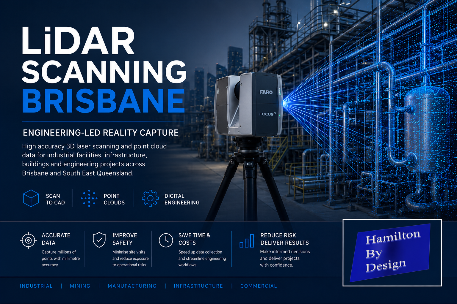
Engineering-led LiDAR scanning in Brisbane showing a terrestrial laser scanner capturing an industrial processing plant with point cloud data for Scan to CAD, reality capture and digital engineering services.

LiDAR Scanning Brisbane โ€“ Engineering-Led 3D Laser Scanning & Digital Engineering Services

LiDAR Scanning Brisbane

Blue 3D LiDAR scanner icon on a tripod with scanning waves

Hamilton By Design provides engineering-led LiDAR scanning services throughout Brisbane and South East Queensland, delivering accurate point cloud data for industrial facilities, mining infrastructure, manufacturing plants, commercial buildings, water treatment facilities and large-scale engineering projects.

Unlike traditional survey-only providers, our team combines practical mechanical engineering, drafting and digital engineering experience with advanced terrestrial laser scanning technology. This allows us to capture existing conditions quickly and accurately while understanding how the data will be used during engineering design, shutdown planning, asset management and construction projects.

Whether you require a simple Scan to CAD deliverable or a complete digital engineering solution, our Brisbane LiDAR scanning services provide a reliable foundation for project success.


What is LiDAR Scanning?

LiDAR (Light Detection and Ranging) is a technology that uses laser pulses to measure millions of points in three-dimensional space. The result is a highly detailed digital representation of an asset, structure or facility known as a point cloud.

LiDAR scanning can accurately capture:

  • Structural steelwork
  • Mechanical equipment
  • Pipework systems
  • Conveyors and materials handling systems
  • Processing plants
  • Buildings and facilities
  • Platforms, stairs and access systems
  • Tanks and pressure vessels
  • Mining and mineral processing infrastructure

The collected data can then be converted into engineering drawings, 3D CAD models, BIM models and asset management information.


Engineering-Led LiDAR Scanning

At Hamilton By Design, LiDAR scanning is supported by real engineering experience.

Our team has experience across:

  • Mechanical engineering
  • Structural drafting
  • Pipework drafting
  • Materials handling systems
  • Smelters and refineries
  • Coal handling and preparation plants (CHPP)
  • Mining infrastructure
  • Manufacturing facilities
  • Water and wastewater treatment plants
  • Industrial shutdown projects

Because we understand how engineering information is used, we focus on capturing the information required for successful project delivery rather than simply collecting point cloud data.


LiDAR Scanning Applications

Industrial Facilities

Capture complete facilities for future engineering, expansion projects and asset management.

Mechanical Engineering

Generate accurate as-built information for equipment upgrades, maintenance planning and reverse engineering projects.

Structural Drafting

Produce existing structural steel models and detailed drafting for modifications and compliance assessments.

Pipework Design

Create accurate pipe routing models and clash detection studies before fabrication and installation.

Construction Verification

Verify installed works against design models and identify deviations before project completion.

Shutdown Planning

Reduce site visits and improve engineering productivity by creating a digital twin of the facility.


Scan to CAD Brisbane

Our Scan to CAD services transform LiDAR point cloud data into usable engineering deliverables including:

  • AutoCAD drawings
  • General arrangement drawings
  • Floor plans
  • Sections and elevations
  • Structural steel models
  • Mechanical equipment models
  • Pipework models
  • Inventor models
  • SolidWorks models
  • STEP and SAT files

This process enables engineering teams to work from accurate existing conditions while reducing project risk.


Benefits of LiDAR Scanning

Improved Safety

Reduce the need for repeated site access and minimise exposure to operational hazards.

Increased Accuracy

Capture millions of measurements with engineering-grade accuracy.

Reduced Project Risk

Identify clashes, access issues and existing site constraints before design begins.

Faster Project Delivery

Engineering teams can work from a complete digital record rather than relying on manual measurements.

Future-Proof Asset Information

Create a permanent digital record for future maintenance, upgrades and expansion projects.


Brisbane Industries We Support

Hamilton By Design supports projects throughout Brisbane and South East Queensland including:

  • Mining and mineral processing
  • Smelting and refining
  • Power generation
  • Water and wastewater treatment
  • Manufacturing
  • Food and beverage processing
  • Ports and logistics
  • Infrastructure projects
  • Commercial buildings
  • Government assets

We regularly support projects throughout:

  • Brisbane CBD
  • Eagle Farm
  • Pinkenba
  • Lytton
  • Port of Brisbane
  • Ipswich
  • Logan
  • Redcliffe
  • Caboolture
  • Toowoomba
  • Gold Coast
  • Sunshine Coast

Deliverables

Typical deliverables include:

  • Registered point clouds (E57, RCP, RCS, LAS)
  • Scan to CAD models
  • AutoCAD drawings
  • Structural drafting packages
  • Mechanical drafting packages
  • Pipework models
  • As-built verification reports
  • BIM models
  • Clash detection studies
  • Engineering support documentation

Why Choose Hamilton By Design?

Hamilton By Design combines practical trade experience, engineering expertise and advanced LiDAR technology to deliver real-world outcomes for industrial projects.

Our team brings experience as:

  • Mechanical Engineers
  • Draftspersons
  • Fitters and Turners
  • Site-based Engineering Personnel
  • Project Leaders
  • Digital Engineering Specialists

This combination allows us to understand both the physical asset and the engineering requirements behind every project.


Hamilton By Design logo displayed on a blue tilted rectangle with a grey gradient background

LiDAR Scanning Brisbane โ€“ Get Started

Whether you require a one-day site scan, a complete facility capture or an engineering-led digital twin solution, Hamilton By Design can provide accurate and reliable LiDAR scanning services throughout Brisbane and Southeast Queensland.

Contact Hamilton By Design today to discuss your LiDAR scanning, Scan to CAD, structural drafting, mechanical drafting and digital engineering requirements.

Contact Us – Talk to Us

Name
Would you like us to arrange a phone consultation for you?
Address

Our Clients

Reality Capture Brisbane title graphic with white text on a blue background promoting reality capture, LiDAR scanning and digital engineering services in Brisbane, Queensland.
3D Scanning Brisbane text graphic on a blue background promoting engineering-led laser scanning and reality capture services in Brisbane.

LiDAR Scanning Brisbane title graphic with white text on a blue background promoting terrestrial LiDAR scanning, point cloud capture and reality capture services in Brisbane, Queensland.
SolidWorks Brisbane title graphic with white text on a blue background promoting SolidWorks mechanical design, 3D CAD modelling and engineering drafting services in Brisbane, Queensland.


Why Up-to-Date Engineering Drawings Matter: Reducing Risk Through Digital Engineering

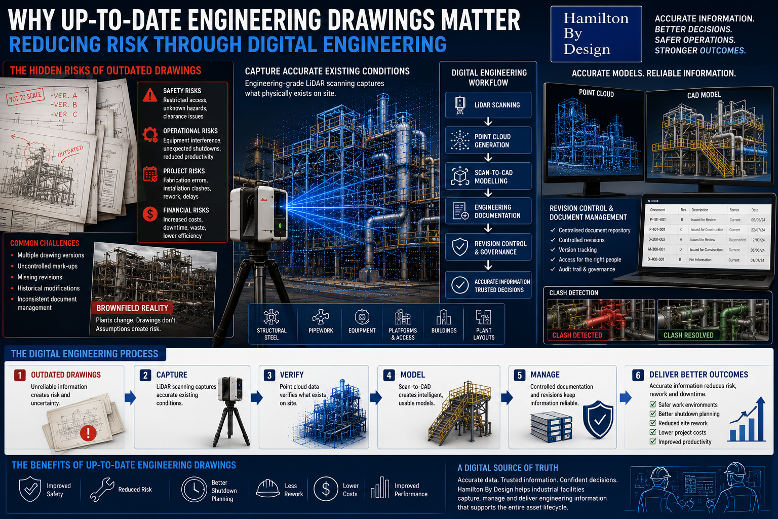
Engineering-grade LiDAR scanning and digital engineering workflow showing how updated engineering drawings reduce project risk and improve asset management.

Industrial facilities rarely remain unchanged throughout their operating life. Equipment is upgraded, structural modifications occur, pipework is rerouted, platforms are added, and maintenance-driven changes become part of everyday operations.

Over time, these modifications can create a disconnect between what exists on site and what engineering documentation says exists.

When engineering drawings no longer accurately represent site conditions, the consequences can extend beyond inconvenience. Outdated information can introduce operational risk, safety concerns, project delays, and increased costs.

At Hamilton By Design, we believe engineering decisions should be based on accurate, measured information rather than assumptions.

Digital engineering workflows help transform existing assets into reliable engineering information that supports safer and more efficient project outcomes.

Why Engineering Drawings Matter

Engineering drawings provide more than dimensions and layouts.

They support:

  • Equipment maintenance
  • Plant upgrades
  • Shutdown activities
  • Fabrication works
  • Safety planning
  • Operational decisions
  • Future modifications

Drawings often become the primary source of information used by:

  • Engineers
  • Maintenance personnel
  • Project teams
  • Contractors
  • Fabricators
  • Operations personnel

If the information is incorrect, downstream decisions may also become incorrect.

3D CAD Modelling Australia service banner for Hamilton By Design

Risks Created by Outdated Drawings

Even relatively small discrepancies between site conditions and engineering documentation can create significant problems.

Potential risks include:

Safety Risks

Outdated information may create:

  • Restricted access areas
  • Unidentified hazards
  • Clearance issues
  • Manual handling challenges
  • Unsafe work conditions

Operational Risks

Incorrect information can contribute to:

  • Equipment interference
  • Unexpected shutdown activities
  • Reduced productivity
  • Increased maintenance complexity

Project Risks

Engineering teams may encounter:

  • Fabrication errors
  • Installation clashes
  • Rework requirements
  • Increased labour costs
  • Schedule delays

Financial Risks

Minor inaccuracies can result in:

  • Increased project costs
  • Extended downtime
  • Material waste
  • Reduced project efficiency

Drawing Revisions and Version Control

Many industrial facilities operate using drawings developed over long periods of time.

Common challenges include:

  • Multiple drawing versions
  • Uncontrolled mark-ups
  • Missing revisions
  • Historical modifications
  • Inconsistent document management

Without effective version control, personnel may unknowingly use outdated information.

Digital engineering workflows support:

  • Revision tracking
  • Controlled updates
  • Centralised documentation
  • Improved information accessibility
  • Better engineering governance

Maintaining a controlled environment for engineering information helps reduce risk.

Existing Condition Capture

One of the most effective methods of maintaining drawing accuracy is capturing what physically exists on site.

Hamilton By Design supports projects through engineering-grade 3D LiDAR scanning to capture:

  • Structural steel
  • Pipework
  • Platforms
  • Mechanical equipment
  • Buildings
  • Existing plant layouts
  • Access systems

Existing condition capture allows engineering teams to work with measured information rather than assumptions.

Brownfield Projects Create Additional Challenges

Brownfield environments commonly include:

  • Historical modifications
  • Legacy equipment
  • Congested layouts
  • Existing structures
  • Limited access areas
  • Undocumented changes

Original documentation often no longer reflects actual site conditions.

Using inaccurate information during brownfield projects can increase:

  • Design uncertainty
  • Installation difficulties
  • Rework
  • Shutdown impacts
  • Fabrication risk

Engineering Governance and Digital Engineering

Digital engineering supports a structured approach to managing engineering information.

Engineering governance may include:

  • Revision control systems
  • Centralised documentation
  • Scan-to-CAD workflows
  • Digital asset information
  • Controlled engineering updates
  • Long-term information management

The objective is creating a digital source of truth where project teams can access reliable information.

Supporting Shutdown Planning

Shutdown periods are often constrained by:

  • Time limitations
  • Labour availability
  • Production requirements
  • Safety considerations

Incorrect engineering information during shutdowns can create:

  • Unexpected site modifications
  • Delays
  • Increased labour requirements
  • Reduced productivity

Accurate digital engineering information supports:

  • Improved planning
  • Better coordination
  • Reduced uncertainty
  • Reduced downtime

Reducing Site Rework

Site rework often results from discovering problems after fabrication or installation begins.

Typical causes include:

  • Missing dimensions
  • Existing condition inaccuracies
  • Equipment clashes
  • Incorrect assumptions
  • Documentation errors

Digital workflows including:

  • Existing condition capture
  • Point cloud modelling
  • Scan-to-CAD processes
  • Clash detection

can help identify issues before they become site problems.

How Hamilton By Design Supports Digital Engineering

Hamilton By Design combines engineering experience with digital workflows including:

  • Engineering-grade 3D LiDAR scanning
  • Existing condition capture
  • Scan-to-CAD workflows
  • CAD modelling
  • Engineering documentation
  • Engineering governance
  • Fabrication-ready deliverables

The goal is not simply creating drawings.

The goal is creating reliable engineering information that supports better operational decisions.

3D LiDAR scanning and 3D modelling service button โ€” laser scanner capturing a point cloud for engineering and CAD modelling
Mechanical engineering services

Better Information Creates Better Outcomes

Drawings influence every stage of an asset lifecycle.

When information becomes outdated, risk increases.

Maintaining accurate engineering documentation supports:

  • Safety improvements
  • Reduced project risk
  • Better shutdown outcomes
  • Reduced rework
  • Improved operational performance

Up-to-date engineering drawings create confidence across engineering, maintenance, and project delivery activities.

Hamilton By Design logo displayed on a blue tilted rectangle with a grey gradient background

Our Clients:

Name
Would you like us to arrange a phone consultation for you?
Address
Finite Element Analysis (FEA) engineering simulation button
Mechanical engineering services