Engineering Drafting Sydney Ports
Hamilton By Design provides engineering drafting services for Sydney ports, marine terminals, wharves, bulk handling facilities, container terminals and industrial port infrastructure. We prepare accurate general arrangement drawings, fabrication drawings, mechanical layouts, structural details, as-built documentation and CAD models for port operators, contractors, fabricators, manufacturers and maintenance teams across Sydney NSW.
Our drafting services support mechanical engineering projects, materials handling upgrades, conveyor modifications, structural steel works, access platforms, equipment layouts, pipework changes and brownfield plant upgrades. By combining practical trade knowledge, mechanical engineering experience, 3D LiDAR scanning and CAD design, we help clients produce clear, buildable and reliable engineering documentation.
Engineering Drafting Services for Sydney Ports
Sydney port facilities require accurate drawings to support safe installation, fabrication, maintenance and future asset management. Many existing facilities have been modified over time, which means old drawings may be incomplete, outdated or missing.
Hamilton By Design supports port infrastructure projects by producing technical drawings that reflect both the design intent and the real site conditions.
Our engineering drafting services include:
- General arrangement drawings
- Fabrication drawings
- Mechanical layouts
- Structural steel details
- Conveyor arrangement drawings
- Transfer chute drawings
- Access platform drawings
- Walkway, stair and handrail drawings
- Equipment layout drawings
- Pipework drafting
- As-built drawings
- Site measure drawings
- Scan to CAD drawings
- 3D CAD modelling
- Drawing markups and revisions
- Drawing package preparation
Drafting for Port Infrastructure and Materials Handling
Port environments often include conveyors, transfer stations, ship loaders, hoppers, chutes, platforms, pipework and support structures. These systems need clear documentation so that designers, fabricators, installers and maintenance teams can work from the same information.
We provide engineering drafting for:
- Conveyor systems
- Conveyor galleries
- Transfer stations
- Transfer chutes
- Ship loading equipment
- Maintenance platforms
- Access stairs and walkways
- Structural steel supports
- Equipment bases and frames
- Guarding and safety access
- Pipework and mechanical services
- Brownfield plant modifications
- Industrial buildings and workshops
This makes the service suitable for Sydney ports, bulk material handling sites, infrastructure projects, manufacturing facilities, utilities, mining support operations and industrial plants.
Sydney NSW and Australia-Wide Support
Hamilton By Design supports engineering drafting projects throughout Sydney NSW, including port and industrial areas around Botany, Port Botany, Glebe Island, White Bay, Sydney Harbour, Kurnell, Parramatta River industrial areas and surrounding logistics hubs.
We also support clients across Newcastle, the Hunter Valley, Central Coast, Brisbane, Melbourne, Adelaide, Perth, Darwin, Mount Isa and regional Australia.
For clients outside Sydney, we can provide drafting support remotely using supplied drawings, site photos, point clouds, 3D scan data, markups and engineering sketches.
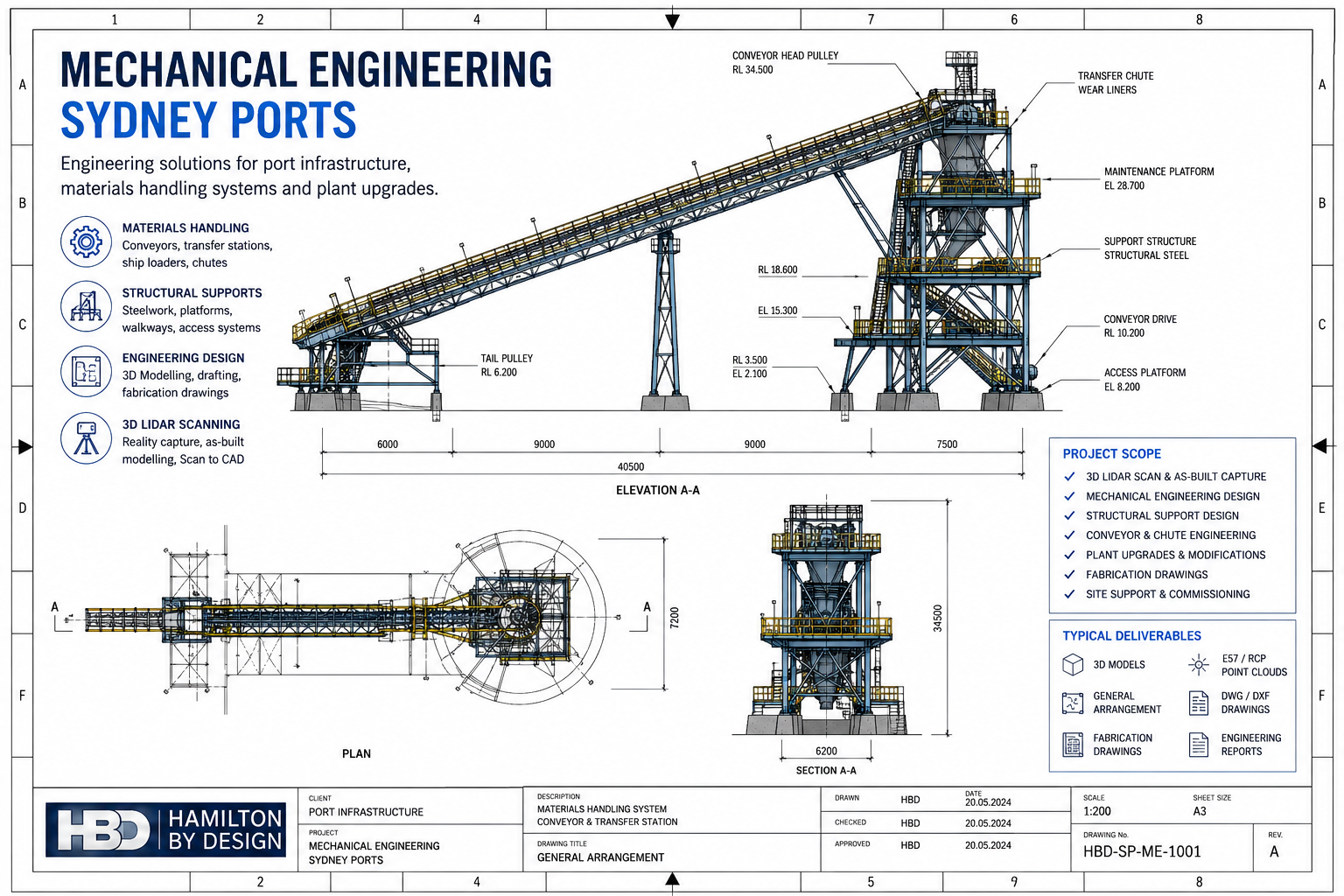
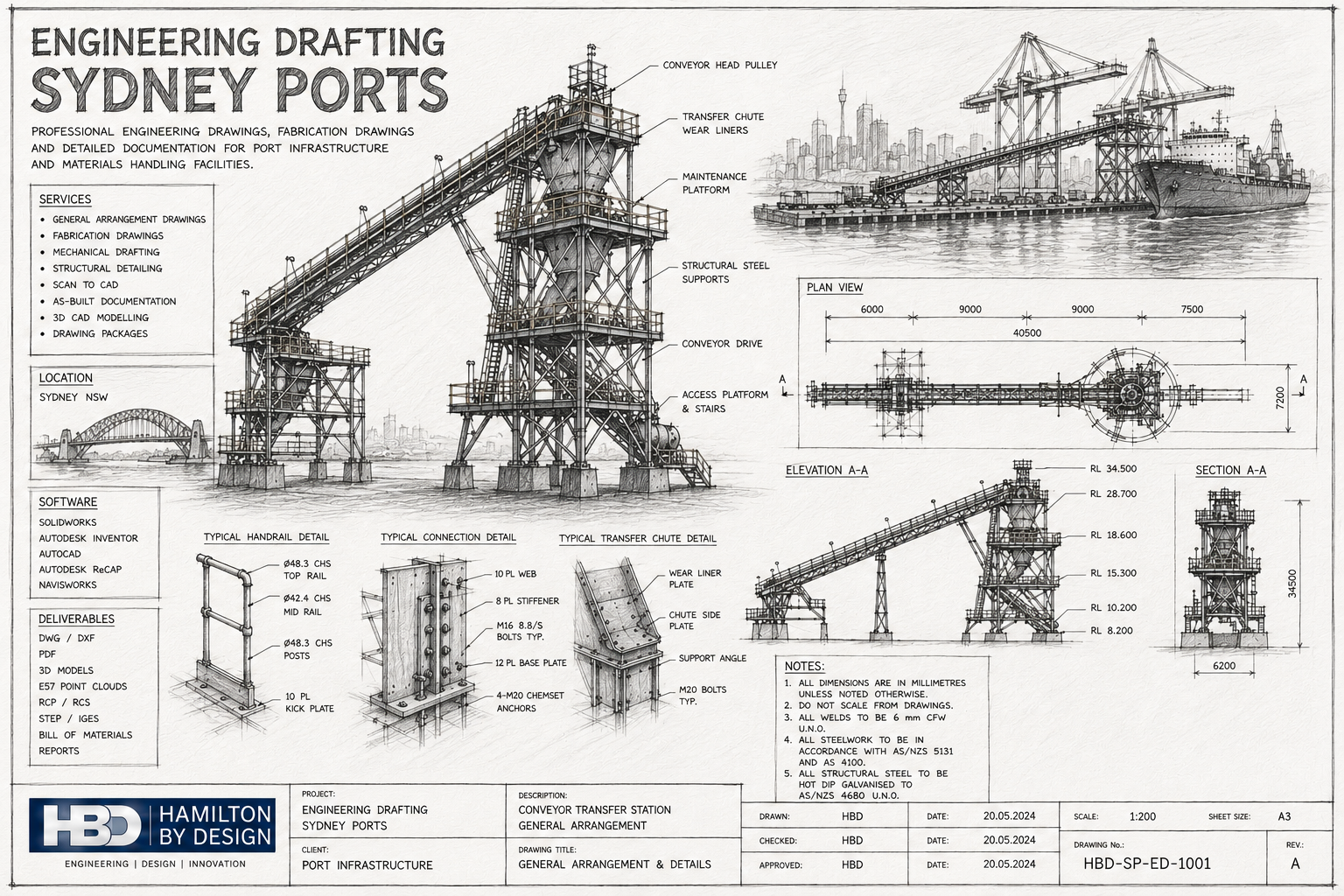
General Arrangement Drawings
General arrangement drawings show how equipment, structures and systems fit together. They are commonly used for design review, client approval, construction planning and installation coordination.
A GA drawing may include:
- Plan views
- Elevation views
- Section views
- Main dimensions
- Equipment locations
- Structural interfaces
- Access clearances
- Connection points
- Drawing notes
- Reference drawings
- Revision history
For Sydney port projects, GA drawings are often required before fabrication drawings are produced. This helps confirm the design layout and reduce the risk of clashes during installation.
Fabrication Drawings
Fabrication drawings provide the detail required to manufacture steelwork, mechanical components and assemblies.
Depending on the project, fabrication drawings may include:
- Plate details
- Weld details
- Material callouts
- Hole sizes and locations
- Cut lengths
- Fold details
- Machining details
- Assembly information
- Bill of materials
- Finish requirements
- Drawing notes
Fabrication drawings are especially important for conveyor supports, platforms, stairs, handrails, guarding, brackets, frames, hoppers, chutes and mechanical assemblies.
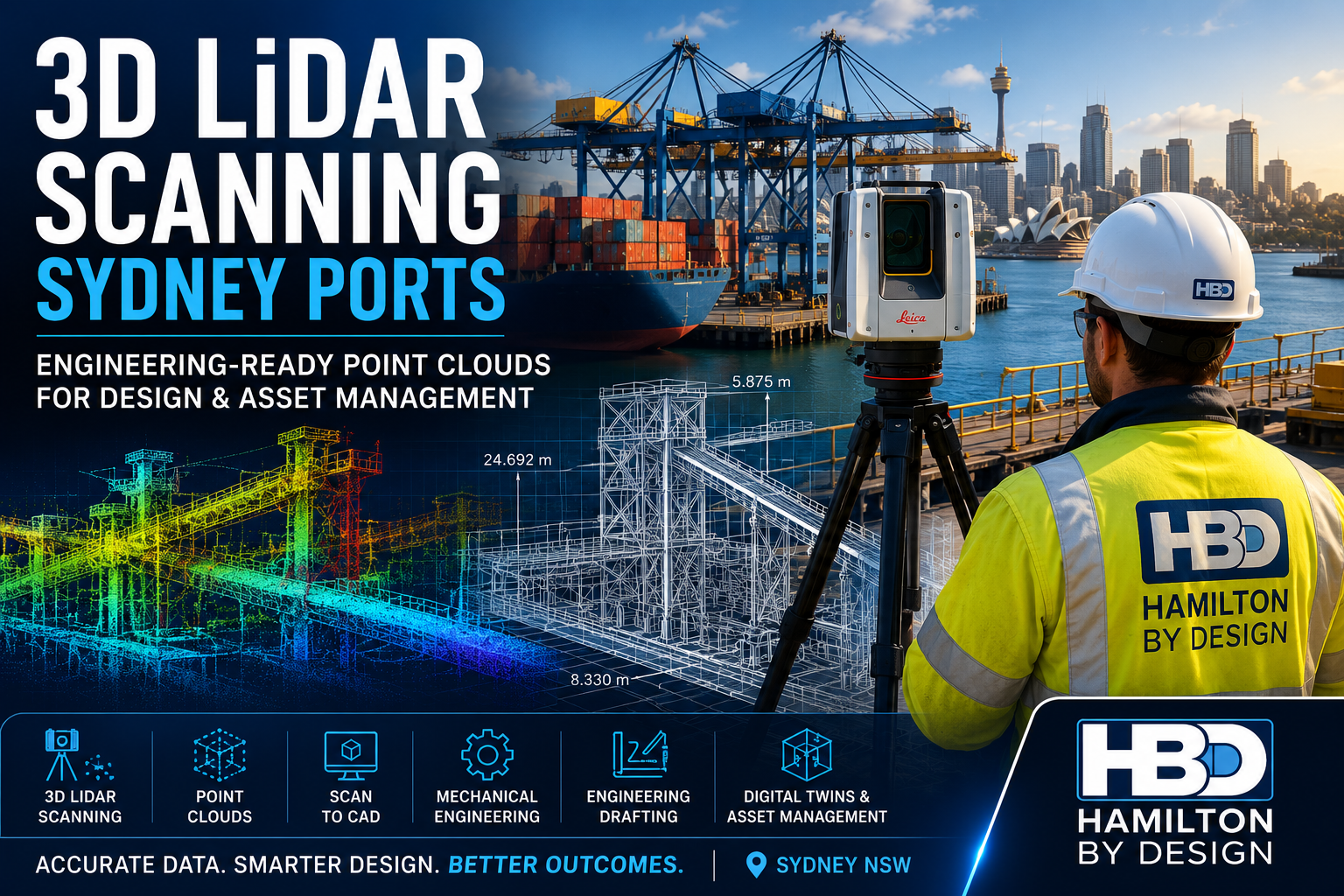
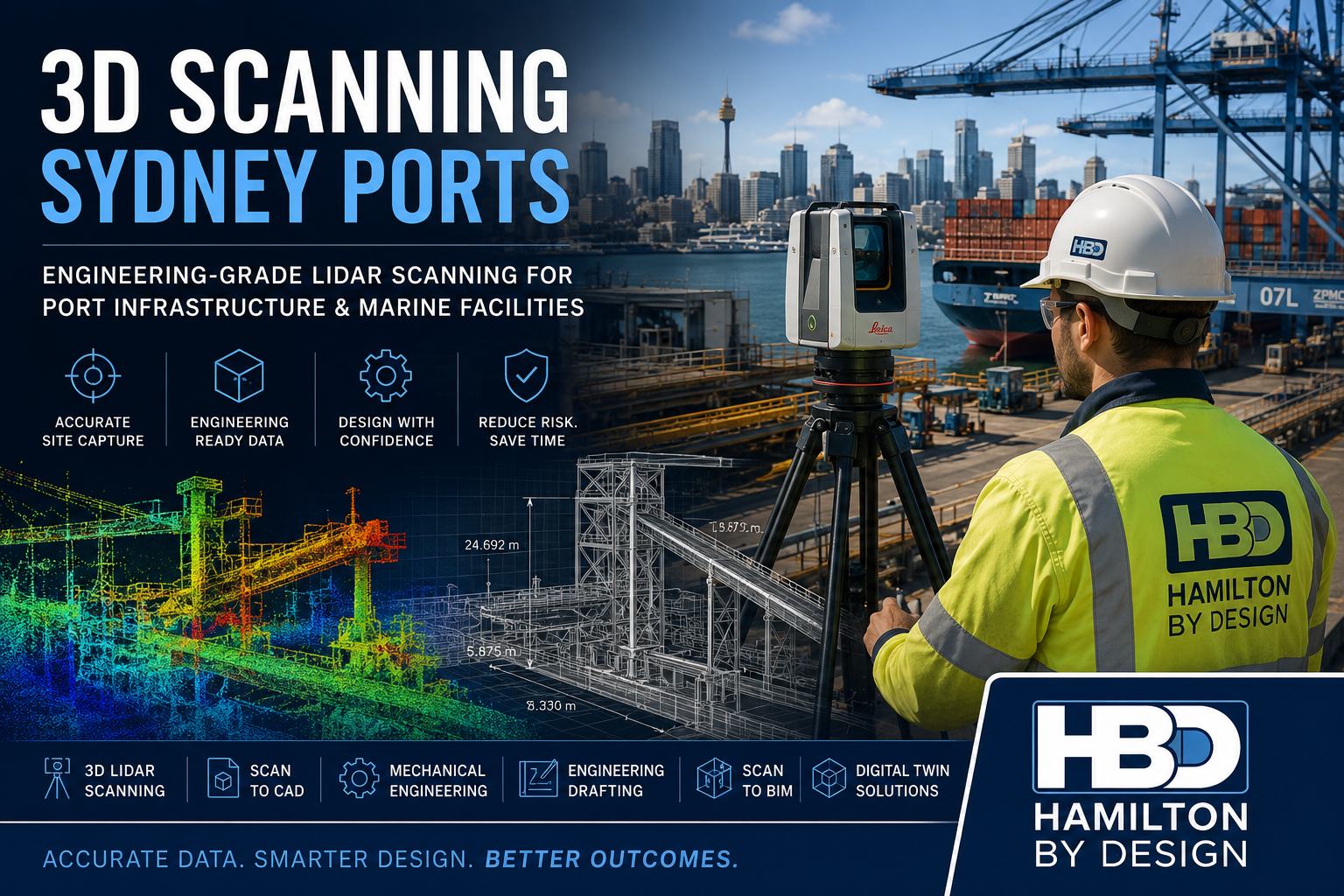
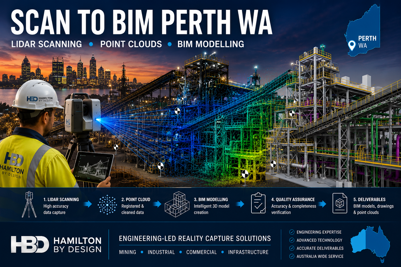
3D LiDAR Scanning and Scan to CAD
Many port projects are completed in brownfield environments where accurate site information is essential. When existing drawings are not reliable, Hamilton By Design can use 3D LiDAR scanning to capture the real site conditions before drafting begins.
3D scanning can capture:
- Structural steel
- Conveyors
- Chutes
- Platforms
- Pipework
- Equipment
- Building layouts
- Access areas
- Obstructions
- Existing services
The scan data can then be converted into CAD drawings, 3D models and as-built documentation.
Typical scan and CAD deliverables may include:
- E57 point clouds
- RCP files
- RCS files
- DWG drawings
- DXF drawings
- SolidWorks models
- Autodesk Inventor models
- STEP files
- PDF drawing packages
- As-built documentation
This workflow helps reduce site rework and improves confidence before fabrication or installation begins.
CAD Software and Technical Capability
Hamilton By Design works with commonly used engineering and drafting platforms to support practical project delivery.
Software and file formats may include:
- SolidWorks
- Autodesk Inventor
- AutoCAD
- Autodesk ReCap
- Navisworks
- STEP
- Parasolid
- DWG
- DXF
- E57
- RCP
- RCS
We can work from supplied sketches, old drawings, site markups, redline drawings, photographs, point cloud data or 3D models.
Relevant Standards and Drawing Considerations
Engineering drafting for port and industrial environments should be clear, consistent and suitable for the intended use.
Depending on the project, drawings may consider:
- AS 1657 for fixed platforms, walkways, stairways and ladders
- AS/NZS 4024 for machine safety and guarding considerations
- AS 3990 for mechanical equipment and steelwork design considerations
- AS 4100 for steel structures where applicable
- Site-specific safety requirements
- Client drawing standards
- Fabricator requirements
- Maintenance access requirements
- Installation constraints
Drawings should be practical, readable and suitable for review by engineers, fabricators, project managers and site teams.
Step-by-Step Drafting Process
1. Project Review
We review the project scope, available drawings, sketches, photos, site information and client requirements.
2. Site Measure or 3D Scan
Where required, we attend site to measure or complete 3D LiDAR scanning to capture the existing conditions.
3. CAD Setup
Existing drawings, scan data or design sketches are brought into the CAD environment.
4. 3D Modelling or 2D Drafting
We prepare 3D models or 2D drawings depending on the project requirements.
5. Engineering Review
Drawings are reviewed for layout, access, interfaces, buildability and design intent.
6. Drawing Issue
The drawing package is issued for review, approval, fabrication, installation or as-built records.
7. Revisions and Final Documentation
Client comments, engineer markups and site changes are incorporated before final issue.
What the Client Receives
Depending on the project scope, clients may receive:
- General arrangement drawings
- Fabrication drawings
- Mechanical detail drawings
- Structural detail drawings
- Conveyor layout drawings
- Access platform drawings
- As-built drawings
- 3D CAD models
- SolidWorks models
- Inventor models
- STEP files
- DWG files
- DXF files
- PDF drawing sets
- Bill of materials
- Drawing registers
- E57 point clouds
- RCP and RCS files
- Engineering notes and reports
The final deliverables are tailored to suit the project, whether the requirement is design review, fabrication, installation, asset management or maintenance planning.
Why Choose Hamilton By Design?
Hamilton By Design combines engineering drafting with practical mechanical engineering and site experience. This is important for port projects where drawings must be more than visually correct. They must also be practical, buildable and suitable for real site conditions.
Our strengths include:
- Mechanical engineering experience
- Trade and fabrication background
- 3D CAD modelling capability
- 3D LiDAR scanning capability
- Brownfield industrial project experience
- Materials handling knowledge
- Conveyor and chute drafting experience
- Port and infrastructure drafting support
- Practical drawing documentation
- Australia-wide project support
We understand the importance of clear drawings for shutdowns, fabrication, maintenance works and plant upgrade projects.
Related Services
Hamilton By Design also provides related engineering and digital design services, including:
- Mechanical Engineering Services
- 3D LiDAR Scanning Sydney Ports
- Scan to CAD Sydney Ports
- Scan to BIM Sydney
- Reverse Engineering Services
- Structural Drafting Services
- Industrial Plant 3D Scanning
- Conveyor Design and Drafting
- Fabrication Drawing Services
These related services allow clients to combine site capture, drafting, modelling and engineering support within one practical workflow.
Frequently Asked Questions
Do you provide engineering drafting for Sydney ports?
Yes. Hamilton By Design provides engineering drafting services for Sydney ports, port infrastructure, marine terminals, conveyors, transfer stations and industrial facilities.
What types of drawings can you produce?
We can produce general arrangement drawings, fabrication drawings, mechanical layouts, structural details, as-built drawings, conveyor drawings and CAD models.
Can you work from old or incomplete drawings?
Yes. We can work from existing drawings, site sketches, photos, redline markups and 3D scan data. Where drawings are unreliable, a site measure or 3D LiDAR scan may be recommended.
Can you provide fabrication drawings?
Yes. We prepare fabrication drawings for steelwork, platforms, brackets, frames, chutes, hoppers, conveyor supports and mechanical assemblies.
Do you provide Scan to CAD services?
Yes. We can convert 3D LiDAR scan data into DWG drawings, 3D CAD models, SolidWorks files and as-built documentation.
What software do you use?
We commonly use SolidWorks, Autodesk Inventor, AutoCAD, Autodesk ReCap and Navisworks.
Can you help with brownfield port upgrades?
Yes. We support brownfield upgrade projects where existing equipment, structures and services must be captured and documented before modification.
Do you provide drawing updates from site markups?
Yes. We can update drawings from redline markups, site measurements, scanned information and engineering comments.
Do you work outside Sydney?
Yes. We support clients across NSW and Australia, including Newcastle, Hunter Valley, Central Coast, Brisbane, Melbourne, Adelaide, Perth, Darwin and regional industrial sites.
What information do you need to prepare a quote?
Useful information includes the project scope, existing drawings, photos, site location, required drawing types, preferred file formats, deadlines and whether a site measure or 3D scan is required.

Contact Hamilton By Design
If you require Engineering Drafting Sydney Ports services, Hamilton By Design can assist with general arrangement drawings, fabrication drawings, CAD modelling, Scan to CAD, as-built documentation and detailed engineering drawing packages for port and industrial infrastructure.
Contact Hamilton By Design to discuss your Sydney port drafting project and prepare a practical drawing solution for your site, workshop or engineering team.
Talk to Us – Contact Us
Our clients: