3D Scanning

How 3D Laser Scanning is Redefining Reality for Design, Construction & Heritage

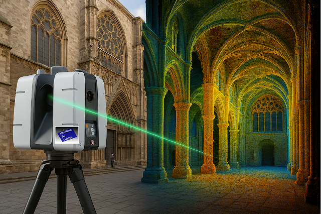
Imagine standing before a centuries-old cathedral, where every carved arch, every stained-glass pane, every weathered stone holds centuries of stories. Capturing its true form and condition with tape measure and camera? Tedious and prone to errors. But with 3D laser scanning, you can digitally freeze every detail—down to the imperfections—turning reality into an exact, manipulable model.

In an age where precision, speed, and data-driven decisions are non-negotiable, 3D laser scanning is no longer “nice to have”—it’s essential. Let’s explore what it is, why it’s transformative, where it’s being used most powerfully, and how you can harness its potential.

What Is 3D Laser Scanning?

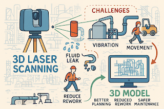
At its core, 3D laser scanning sometimes called terrestrial laser scanning, (TLS) is the emission of laser pulses toward surfaces, recording the time it takes for those pulses to bounce back. From that comes a dense “point cloud” — billions of precise data points mapping shape, texture, orientation, and distance.

These point clouds become high-fidelity models, maps, meshes, or BIM ready files. Whether you’re scanning building exteriors, interiors, or industrial components, the result is more than just imagery—it’s measurable, analyzable geometry.

How It Works — The Process

  1. Preparation & Planning

    Define what you need: the level of detail (LOD), resolution, range, and whether external conditions (light, weather) will interfere.

  2. Data Capture

    Position the scanner at multiple stations to cover all surfaces. Use targets or reference markers for alignment and capture with overlapping scans.

  3. Processing & Registration

    Merge scans to align them properly, clean noise, filter out irrelevant data (like people, moving objects), calibrate.

  4. Post-processing & Deliverables

    Convert point clouds into usable outputs—floorplans, sections, elevations, 3D meshes, BIM models, virtual walkthroughs. Run analyses (clash detection, deformation etc.).

  5. Integration & Use

    Use the data in design, restoration, facility management, or documentation. The quality of integration (into BIM, GIS, CAD) is key to unlocking value.
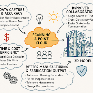
Key Benefits

Benefit What It Means in Practice Real-World Impact
Extreme Precision Sub-millimetre to millimetre accuracy depending on the scanner and conditions. Less rework. Better fit for retrofit, renovation, or mechanical systems in tight tolerances.
Speed + Efficiency Collect large amounts of spatial data in far less time than traditional measurement. Faster project turnaround. Reduced site time costs.
Non-Contact / Low Disruption Good for fragile structures, hazardous or difficult-to-access places. Preserves integrity of heritage buildings; safer for workers.
Comprehensive Documentation Full visual & geometric context. Informs future maintenance. Acts as an archival record.
Better Decision Making & Conflict Detection Early clash detection; scenario simulation; what-if modelling. Avoids costly mistakes; helps build consensus among stakeholders.
Enhanced Visualisation & Communication Stakeholders can see exactly what exists vs. what’s being proposed. Improves client buy-in, regulatory approvals, fundraising.

Applications: Where It Shines

  • Architecture & Renovation: As-built models, restoration of heritage sites.

  • Infrastructure & Civil Engineering: Bridges, tunnels, rail track alignments.

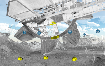
  • Industrial & Manufacturing: Machine part audits, reverse-engineering, plant layout.

  • Heritage & Preservation: Documenting fragile monuments, archaeological sites.

  • Facility Management: Digital twins, maintenance, asset tracking.

  • Environment & Surveying: Terrain mapping, forestry, flood risk mapping (especially when combined with aerial systems or mobile scanning).

Challenges & Best Practices

Nothing is perfect. To get the most out of 3D laser scanning, anticipate and mitigate:

  • Environmental factors: Light, dust, rain, reflective surfaces can introduce noise.

  • Data overload: Massive point clouds are large; need strong hardware & efficient workflows.

  • Alignment & registration errors: Overlaps, control points, and calibration are vital.

  • Skill & Planning: Good operators + good planning = much better outcomes.

Key best practices:

  • Use reference targets for precise registration.

  • Capture overlap of 30-50% between scan positions.

  • Break project into manageable segments.

  • Clean noise early.

  • Think ahead about deliverables and how clients will use the data (design, BIM, VR etc.).

Case Studies & Stories

  • Heritage in Danger: A cathedral in Europe threatened by pollution and structural decay was laser scanned. The point cloud revealed minute deformations, enabling an accurate restoration plan—saving costs and preserving history.

  • Infrastructure Efficiency: A civil engineering firm reduced design clashes by 80% on a complex highway project by integrating scans with their BIM workflow.

  • Industrial Switch-Over: Manufacturing plant layout was reconfigured using scan data; downtime reduced because the virtual model matched reality better than the old blueprints.

Software, Tools & Ecosystem

While scanners are vital, the software ecosystem is what unlocks value. Tools that turn raw data into actionable insights include:

  • Reality capture tools (processing point clouds).

  • BIM / CAD integration (e.g. Revit, AutoCAD).

  • Visualization tools (VR, AR, walkthrough).

  • Data sharing & collaboration platforms.

  • Cloud storage / processing if large point clouds.

SaaS/cloud-based workflows are increasingly important to share among remote teams, facilitate stakeholder review, and ensure data is accessible beyond just technical users.

Why It Matters Now

  • Global pressures (heritage, sustainability, faster build cycles, remote work) are raising the bar.

  • Clients expect transparency, accuracy, minimized risk.

  • Regulatory compliance and “as-built” requirements are stricter.

  • Digital twins & smart infrastructure demand high fidelity data.

3D laser scanning acts as a bridge: between physical world and digital twin; between heritage past and future; between design promise and build reality.

If you have a survey scan and want to make sense of point cloud data, contact Hamilton By Design

#Scanning Sydney #3D Laser Scanning #3D Point Cloud Scanning #3D Laser Scanning Brisbane #3D Laser Scanning Mitcham London #3D Laser Scanning Perth #3D Laser Scanning Sydney #3D Mechanical Engineering

Transforming Projects with 3D Scanning in Sydney

3D Lidar Scanning in Sydney

Sydney’s construction and engineering sectors are evolving fast — and 3D laser scanning is at the heart of this transformation. Whether you’re upgrading an industrial plant, planning a new commercial development, or managing complex infrastructure projects, having an accurate digital representation of your site is crucial.

3D scanning in Sydney delivers millimetre-precise point clouds that eliminate guesswork, reduce rework, and streamline project timelines. By capturing every detail — from structural steel to pipework — in a single, high-resolution scan, project teams can make faster, smarter decisions.

3D Scanning Sydney

At Hamilton by Design, we provide professional 3D laser scanning services across Sydney, helping engineers, architects, and builders create reliable as-built models, detect potential clashes before construction begins, and improve overall project efficiency.

This intro does three important things:
– Localizes the service by highlighting Sydney projects.
– Uses your primary keyword (“3D scanning Sydney”) naturally for SEO.
– Sets up the value proposition — accuracy, time savings, risk reduction — encouraging readers to keep reading.

Would you like me to also write two or three follow-up paragraphs to turn this into a standalone blog article specifically for Sydney, including local case study examples or industry use cases (e.g., infrastructure upgrades, commercial builds, heritage sites)? This would help it rank for long-tail search queries like “3D scanning services Sydney for construction”.

For more info Hamilton By Design

3d Scanning Sydney

Lidar Scanning Sydney | Point Cloud Scanning Sydney | 3D Modeling Sydney

Are You Getting the Full Value from Your Point Cloud Data?


3D Scanning

The world of manufacturing and fabrication is moving faster than ever. Point cloud scanning and 3D modeling have made it easier to capture reality with incredible accuracy — but simply collecting data isn’t enough.

Without the right expertise, point clouds often sit unused, underutilized, or worse — lead to costly mistakes when converted into incomplete or inaccurate drawings.

3D Scanning

That’s why mechanical engineering consultants are becoming essential partners for forward-thinking businesses. They don’t just process point clouds — they turn them into:

  • High-precision 3D models that match real-world conditions

  • Fabrication-ready drawings that reduce errors and rework

  • Actionable insights that save time, money, and frustration

This is no longer just about technology — it’s about strategy and execution.

Read our full article to discover why now is the perfect time to engage consultants who can unlock the power of your point cloud data:


It’s Time to Level Up: Why Mechanical Engineering Consultants Are Key to Unlocking the Power of Point Cloud to 3D Modeling

Engineering hashtagManufacturing hashtagPointCloud hashtag3DModeling hashtagFabrication hashtagDigitalTwin hashtagMechanicalEngineering hashtagIndustry40 hashtagInnovation

Chute Design at Hamilton By Design


At Hamilton by Design, we see ourselves as more than engineers — we are problem-solvers who bring both science and experience to the table. Every bulk material transfer is unique, and each one carries its own challenges. By combining the principles of particle physics with decades of hands-on site experience, we design chutes and transfer points that perform in the real world, not just on a computer screen.

Materials Handling

We are a small, specialised company, not a large corporate machine. That means you deal directly with the people who understand your operation, your materials, and your challenges. We take pride in our ability to stand on-site, watch the flow of material, and recognise behaviours that only years of experience can teach. This gives us the clarity to engineer practical solutions that keep your plant running reliably.

For us, your success is our success. We measure our achievement not by the number of projects we complete, but by the value we add to your operation — less dust, less wear, fewer stoppages, more tonnes moved.

Learn more about our approach and solutions Hamilton By Design – Chute Design

Mechanical
Engineering
| Structural
Engineering

Mechanical
Drafting
| Structural
Drafting

3D
Laser Scanning
| 3D
CAD Modelling
| 3D
Scanning

SolidWorks
Contractors in Australia

Hamilton By Design – Blog

Consulting Engineers

About Us –
Hamilton By Design

Designing for Developing Hazards: Lessons from the Derrimut Crane Collapse

Designing for Developing Hazards

Crane accidents are among the most visible reminders of the risks inherent in construction. The collapse of a crane at a data centre site in Derrimut, Melbourne, brought attention once again to the vulnerability of temporary lifting structures. While formal investigations are still underway, and no conclusions should be drawn prematurely, the event provides a valuable opportunity for reflection within the engineering community.

This article considers the collapse not as an isolated failure but as a case study in hazard identification. In particular, it highlights how mechanical engineers must adapt from a static, design-phase view of risk to a dynamic, real-time approach to hazard monitoring. Wind, soil stability, and load conditions are well-known hazards. But with modern tools — including LiDAR scanning for obstacle detection — engineers can move toward a future where developing hazards are continuously tracked, anticipated, and controlled.


From Hazard Identification to Live Hazard Monitoring

Hazard identification has traditionally been a design-phase process: engineers anticipate risks, apply safety factors, and create conservative margins. This remains essential. Yet the Derrimut collapse illustrates the limits of a static model in a dynamic environment.

Cranes are exposed to evolving hazards:

  • Wind gusts that change minute by minute.

  • Soil stability that shifts with rainfall, excavation, or groundwater.

  • Obstacles such as power lines or nearby structures, which can create cascading risks if struck.

  • Load dynamics, including swinging or sudden movement.

What is needed is a transition from hazard identification to hazard monitoring: a continuous loop where design assumptions are validated against real-time data, and where developing risks are detected before they become failures.


Wind Hazards: Predicting the Unpredictable

Wind is a leading cause of crane collapses. Engineers know the mathematics: pressure rises with the square of velocity. A 50 km/h gust exerts twice the force of a 35 km/h breeze.

Most cranes today are fitted with anemometers and alarms, but these are often basic: a single reading at a single point, with alarms sounding when preset thresholds are exceeded. This approach can miss:

  • Local gust variability along a long jib.

  • Interaction with crane orientation (wind hitting the broadside is more critical than aligned wind).

  • Forecasted conditions that could deteriorate within minutes.

Next-generation wind monitoring could include:

  • Multi-point sensor arrays on cranes.

  • Integration with Bureau of Meteorology gust forecasts.

  • AI models predicting when risk thresholds will be exceeded, not just reporting when they are crossed.

  • Automatic crane repositioning to minimise wind exposure.

This transforms alarms from reactive to predictive — the difference between warning after a hazard is present and anticipating before it materialises.


Soil Hazards: Stability Under Load

Ground conditions are another silent but critical hazard. Outriggers may impose hundreds of kilonewtons on pads, meaning even small soil weaknesses can lead to tilting or overturning.

Engineering practice already includes soil investigations: boreholes, CPT, SPT, and FEA models. But these tests capture conditions before installation, not necessarily during operation. Soil strength can change due to rainfall, groundwater shifts, or nearby excavation.

Live soil monitoring can be achieved with:

  • Load cells under mats to track ground reactions.

  • Settlement gauges to detect tilt.

  • Piezometers for pore pressure during rain events.

  • Integrated warnings when ground resistance trends downward.

This approach acknowledges soil as a living hazard that changes daily.


LiDAR and Obstacle Detection: Power Lines and Proximity Hazards

One striking feature of the Derrimut collapse was the crane’s boom striking power lines. Contact with utilities is a recurrent hazard in crane operations worldwide. While operators are trained to maintain exclusion zones, in practice visibility, fatigue, or unexpected boom movement can still lead to contact.

LiDAR scanning offers a solution.

  • How it works: LiDAR (Light Detection and Ranging) emits laser pulses to map surroundings in 3D with centimetre accuracy. Mounted on a crane, it can create a live digital map of nearby obstacles.

  • Application in cranes:

    • Detecting and mapping power lines, buildings, or scaffolding in the lift path.

    • Setting proximity alarms when a boom, hook, or load approaches a defined clearance.

    • Combining with wind data to predict if gusts could push the load into restricted zones.

In aviation, LiDAR and radar-based systems are standard for obstacle detection. In construction, adoption is patchy. Yet the technology exists, is cost-effective, and could dramatically reduce risks of contact with hazards like live power lines.

LiDAR’s strength lies not only in static mapping but in detecting movement — for example, when a suspended load begins to swing toward a power line due to a gust. This is a quintessential developing hazard, one that static design could never fully capture.


Integrated Hazard Dashboards

Wind, soil, and LiDAR obstacle detection all provide valuable data. But their true power lies in integration. Imagine a crane operator’s cabin equipped with a single dashboard displaying:

  • Wind speeds and gust forecasts, colour-coded for risk.

  • Soil reaction forces under each outrigger, with alerts if settlement is trending.

  • LiDAR mapping of nearby structures and power lines, with real-time clearance zones.

  • Predictive risk models showing probability of instability or contact over the next 30 minutes.

This integration mirrors aviation’s cockpit: multiple inputs fused into actionable guidance. For cranes, such systems could shift the operator’s role from reactive decision-maker to proactive risk manager.


AI as a Predictive Partner

Artificial Intelligence has a natural role in hazard monitoring:

  • Sensor fusion: combining wind, soil, and LiDAR inputs into coherent risk profiles.

  • Prediction: learning from past crane incidents to forecast when risks are likely to escalate.

  • Decision support: providing operators with clear options (“safe to continue lift for 20 minutes” / “halt operations — clearance margin < 1m”).

The challenge is balance. AI should not replace human oversight, but augment it. Over-reliance could create new vulnerabilities if operators become complacent. The design challenge is to build AI into systems that support human judgment rather than substitute for it.


Ethics and Engineering Responsibility

The Derrimut collapse underscores the ethical responsibility of mechanical engineers. Hazard identification is not just a design requirement; it is a matter of public safety. The profession has a duty to anticipate, detect, and control risks wherever possible.

The tools now exist to monitor developing hazards — wind sensors, soil gauges, LiDAR scanners, and AI dashboards. If lives and infrastructure can be protected through wider adoption of these tools, then the question becomes one of responsibility: should they be optional, or mandatory?


Open Questions for the Future

  1. Would integrated live monitoring have reduced the risks at Derrimut?

  2. Should all cranes be fitted with LiDAR obstacle detection as standard?

  3. Do we already have enough technology, but lack regulation and enforcement?

  4. What role should AI play in balancing predictive insight with operator autonomy?


Conclusion

The Derrimut incident remains under investigation. No conclusions can be drawn about its specific cause until findings are published. Yet as a case study, it illustrates the broader point that hazards in crane operations are dynamic. Wind, soil, obstacles, and loads evolve minute by minute.

Mechanical engineers have the tools — wind sensors, soil monitors, LiDAR scanners, integrated dashboards, and AI — to detect these developing hazards. The challenge is to move from a culture of static design assumptions to one of continuous hazard monitoring.

The ultimate professional question is this: If aviation can integrate multiple systems to monitor and predict hazards, why can’t construction do the same for cranes? And if we can, how soon will we accept the ethical responsibility to make it standard?


References and Further Reading

  • ISO 4301 / AS 1418 — Crane standards covering stability and wind.

  • ISO 12480-1:2003 — Safe use of cranes; includes environmental hazard monitoring.

  • WorkSafe Victoria Guidance Notes — Crane safety management.

  • Holický & Retief (2017)Probabilistic treatment of wind action in structural design.

  • Nguyen et al. (2020)Real-time monitoring of crane foundation response under variable soil conditions.

  • Liebherr LICCON — Example of integrated load and geometry monitoring.

  • FAA LLWAS — Aviation’s real-time wind shear alert system, model for construction.

  • Recent research in LiDAR obstacle detection (e.g., IEEE Transactions on Intelligent Transportation Systems) — showing LiDAR’s potential in complex environments.


Structural
Drafting
| Mechanical
Drafting
| 3D
Laser Scanning

Mechanical Engineering

Consulting Engineers


How Mechanical Engineering and Technology Are Shaping the Future of Mining in Australia

Discover how mechanical engineering, government funding, and digital innovation are driving the future of mining in Australia. Learn how Hamilton By Design leads the change.

Australia’s mining industry is undergoing one of its most significant transformations in decades. At the heart of this change lies the convergence of mechanical engineering innovation, government-backed funding, and cutting-edge technology.

With over $750 million in federal support for metals manufacturing and state-based funding for METS innovation, mechanical engineers are now in a position to redefine how mining operations are designed, maintained, and optimised.

At Hamilton By Design, we are helping clients across the country harness these changes—offering smart mechanical solutions that are efficient, resilient, and future-ready.


Key Opportunities: How Technology is Reshaping Mechanical Engineering in Mining

1. Government Funding is Fueling Innovation

In March 2025, the Australian Government announced a $750 million investment to boost advanced manufacturing and metals production in Australia.

🔗 Backing Our Metals Manufacturers – Federal Government

This funding opens doors for:

  • Prototyping new mechanical assemblies

  • Automation upgrades for existing mining plants

  • Local manufacturing partnerships to reduce supply chain risk

At Hamilton By Design, we are already supporting mining clients to align their capital projects with these funding pathways.


2. Digital Tools Enhance Mechanical Performance

According to the CSIRO METS Roadmap, digitalisation and automation are critical for the next phase of mining growth.

We implement:

  • LiDAR scanning for as-built plant modelling

  • Finite Element Analysis (FEA) for structural design optimisation

  • Predictive maintenance planning using real-time sensor data

These tools not only extend the life of critical components but also enhance safety, reduce downtime, and support remote operations.


3. WA and NSW Governments Are Supporting METS Innovation

The Western Australian government continues to support Mining Equipment, Technology and Services (METS) innovation and commercialisation through its METS Innovation Grants.

🔗 WA METS Innovation Funding

This creates opportunities for mechanical engineering firms to:

  • Collaborate with OEMs and fabricators

  • Introduce novel materials and designs for harsh mining environments

  • Lead the push toward zero-emissions equipment and sustainable design

Hamilton By Design’s agile project delivery and deep mechanical experience allow us to integrate seamlessly with these innovation pipelines.


The Challenges: Bridging the Gap Between Legacy and Future

Despite the exciting momentum, the sector also faces critical challenges:

  • Skills Gaps: Many engineers are not yet equipped with digital or automation skills.

  • System Complexity: Mechanical systems are increasingly integrated with electrical and digital subsystems, requiring multidisciplinary design thinking.

  • Capital Risk: Large investments in automation must deliver measurable value, which requires robust mechanical frameworks.

Hamilton By Design addresses these risks by offering not only high-quality design services, but also strategy, planning, and training support to ensure seamless project delivery.


Why Hamilton By Design is Your Engineering Partner of the Future

We don’t just design parts—we engineer solutions.

Our core services include:

  • Mining mechanical design (transfer chutes, diverter systems, sheet metal)

  • Structural and stress analysis (using FEA and vibration simulation)

  • LiDAR-enabled plant scanning for reverse engineering and documentation

  • Sustainable, future-ready mechanical engineering consultancy

We work with clients across NSW, WA, QLD, and SA, offering nationwide support for design, development, and delivery.


Let’s Engineer the Future Together

Mechanical engineering is no longer just about function—it’s about intelligence, adaptability, and sustainability.

At Hamilton By Design, we help mining companies, fabricators, and OEMs thrive in this new landscape. Whether you’re applying for funding, upgrading equipment, or redesigning your processing infrastructure, we have the tools, experience, and innovation to lead you forward.

🔗 Contact us at www.hamiltonbydesign.com.au

📧 Or get in touch to start a project discussion today.