From Reality to Design: How 3D Scanning Powers Engineering Outcomes in Sydney

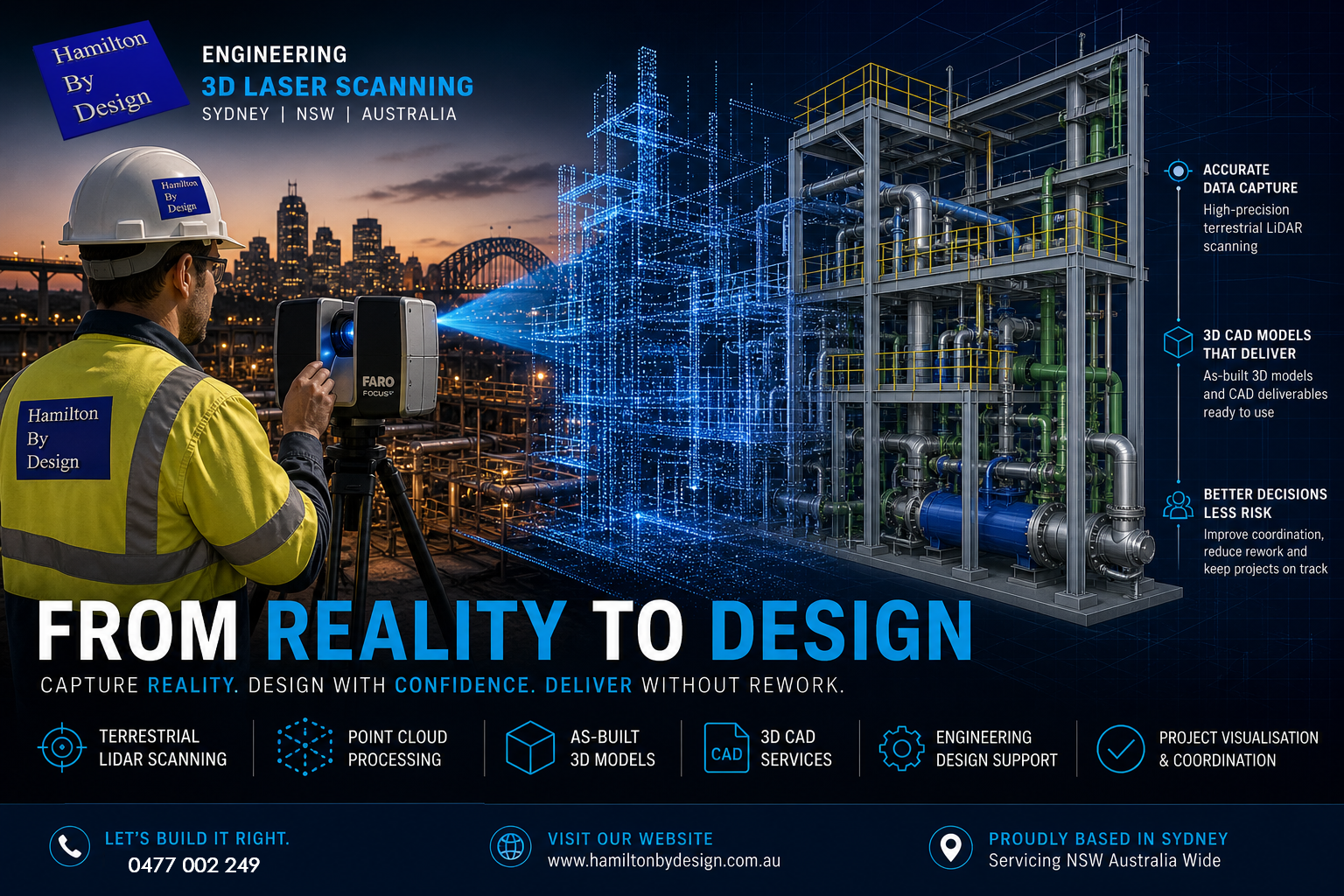
Engineer performing terrestrial LiDAR scanning on a Sydney construction site with point cloud transitioning into 3D CAD model

In todayโ€™s construction and industrial environment, the gap between what was designed and what actually exists on site is where most project risk lives.

Blue 3D LiDAR scanner icon on a tripod with scanning waves

Steel doesnโ€™t sit where drawings say it should. Pipework clashes with new installs. Structural tolerances stack up. And when projects move fast, those risks become expensive.

This is where engineering-led 3D scanning and design changes everything.

At Hamilton By Design, we donโ€™t just capture data โ€” we convert reality into accurate, buildable engineering outcomes.


The Shift from Measuring to Reality Capture

Traditional site measurement methods rely on tape measures, total stations, and assumptions. They work โ€” but they introduce risk.

Modern projects are moving toward terrestrial LiDAR scanning, using high-accuracy laser-based systems to capture millions of data points across a site.

A terrestrial LiDAR scanner works by emitting laser pulses and measuring the return time to build a precise 3D representation of the environment โ€” known as a point cloud.

This process, often referred to as a terrestrial scan, creates a true digital record of:

  • Structural steel
  • Pipework systems
  • Equipment layouts
  • Buildings and facades
  • Complex plant geometry

The result is not an interpretation โ€” it is reality.


From Point Cloud to As-Built 3D Model

Capturing data is only the first step.

The real value comes from converting that scan into an as-built 3D model that engineers, designers, and fabricators can actually use.

This is where many providers fall short.

At Hamilton By Design, we deliver:

  • Engineering-grade 3D CAD services
  • Parametric models (not mesh files)
  • Fabrication-ready geometry
  • Drawings aligned to Australian standards

We donโ€™t produce STL or OBJ files that sit unused.
We produce editable 3D engineering design models that integrate directly into your workflow.

Because ultimately โ€” scanning is not the deliverable.

Design is.


3D Scanning on Construction Sites

The use of 3D scanning on construction sites is growing rapidly โ€” and for good reason.

Projects across Sydney are using LiDAR to:

  • Verify structural installation before fit-up
  • Coordinate mechanical and piping systems
  • Reduce rework during shutdowns
  • Validate contractor work against design intent
  • Capture existing conditions for upgrades

Whether itโ€™s a building scan, plant upgrade, or infrastructure project, the ability to see the full site in 3D changes how teams make decisions.

Instead of relying on drawings โ€” teams work from reality.


Top 3D Scanning Platforms for Project Coordination

Not all scanning workflows are equal.

The top 3D scanning platforms for construction site visualisation and project coordination combine accurate capture with accessible data environments.

Typical platforms include:

  • FARO SCENE for registration and processing
  • Autodesk ReCap for cloud-based coordination
  • 3DEXPERIENCE for engineering governance and collaboration

However, the platform is only part of the equation.

Without engineering understanding, even the best software becomes a viewer โ€” not a solution.

Thatโ€™s why our workflow is built around:

Scan โ†’ Model โ†’ Design โ†’ Deliver


Engineering-Led 3D Design

What sets Hamilton By Design apart is simple:

We are a mechanical engineering business first โ€” not a scanning company.

Our team uses LiDAR to support:

  • 3D design engineering
  • Structural modifications
  • Conveyor and chute design
  • Pipework upgrades
  • Equipment integration

We scan with the intent of answering one question:

๐Ÿ‘‰ Will it fit?

Because in engineering โ€” thatโ€™s what matters.


Why โ€œ3D Scanner Service Near Meโ€ Isnโ€™t Enough

Many clients search for a โ€œ3D scanner service near meโ€ or look at 3D scanner hire as a cost-saving measure.

But scanning hardware alone does not solve engineering problems.

Without:

  • Proper scan planning (line of sight, density, coverage)
  • Registration accuracy
  • Engineering interpretation
  • CAD modelling capability

โ€ฆthe result is just raw data.

We often see projects where scanning was completed โ€” but nothing usable was produced.

Thatโ€™s why we offer both:

  • Full 3D scan services
  • 3D scanner hire (with guidance)
  • End-to-end modelling and design support

Applications Across Buildings and Industry

Our 3D scanning building services and industrial workflows support a wide range of sectors across Sydney and NSW:

Construction & Buildings

  • As-built verification
  • Facade capture
  • Structural coordination
  • Scan-to-BIM workflows

Industrial Plants

  • Brownfield upgrades
  • Shutdown planning
  • Equipment replacement
  • Pipe routing and clash detection

Infrastructure

  • Rail and transport assets
  • Utilities and pump stations
  • Structural assessments

Whether itโ€™s a commercial building or a complex processing plant, the principle is the same:

Capture reality. Design with confidence. Deliver without rework.


The Future: Digital Engineering Driven by LiDAR

LiDAR is not just a tool โ€” it is the foundation of modern digital engineering design.

As projects become more complex, the ability to:

  • Capture accurate site data
  • Build reliable 3D models
  • Coordinate across teams
  • Maintain a single source of truth

โ€ฆwill define successful delivery.

At Hamilton By Design, we combine:

  • Terrestrial LiDAR scanning
  • 3D CAD services
  • Engineering design expertise

to ensure that what gets built โ€” matches what was intended.


3D LiDAR scanning and 3D modelling service button โ€” laser scanner capturing a point cloud for engineering and CAD modelling
Mechanical engineering services

Work With an Engineer-Led 3D Scanning Team

If youโ€™re planning a project in Sydney or across NSW and need:

  • A 3D scan service
  • An as-built 3D model
  • 3D engineering design support

weโ€™re ready to help.

Because the difference between scanning and engineering is simple:

๐Ÿ‘‰ One captures data.
๐Ÿ‘‰ The other delivers outcomes.

Hamilton By Design logo displayed on a blue tilted rectangle with a grey gradient background


Mechanical Engineering | Structural Engineering


Hamilton By Design provides engineering-led 3D scanning, LiDAR scanning, mechanical engineering and digital engineering services throughout Sydney and Greater Sydney.

Explore our related Sydney services:


  • 3D Scanning Sydney โ€“ Engineering-grade terrestrial laser scanning, as-built surveys and point cloud capture for industrial, infrastructure and commercial projects.
  • Reality Capture Sydney โ€“ High-accuracy reality capture, digital twins, asset documentation and engineering-grade site verification.
  • Scan to CAD Sydney โ€“ Convert point cloud data into AutoCAD, SolidWorks, Inventor and other engineering-ready CAD deliverables.
  • Point Cloud Modelling Sydney โ€“ Engineering-grade point cloud processing, clash detection, as-built verification and 3D modelling.
  • Mechanical Engineering Sydney โ€“ Mechanical design, plant upgrades, materials handling systems, conveyors, chutes, platforms and engineering support.
  • Structural Drafting Sydney โ€“ Structural steel drafting, fabrication drawings, GA drawings, workshop detailing and as-built documentation.

Hamilton By Design supports projects throughout Sydney CBD, Parramatta, Liverpool, Penrith, Blacktown, Chatswood, Alexandria, Mascot, Newcastle and the Central Coast.


Our Clients

Contact Us – Talk to Us – Work with Us

Name
Would you like us to arrange a phone consultation for you?
Address
3D LiDAR Scanning Darwin for engineering surveys, laser scanning, reality capture and point cloud modelling services
3D LiDAR Scanning Australia engineering services for laser scanning, reality capture, scan-to-CAD, Scan-to-BIM and as-built documentation across Australia
3D LiDAR scanning services on the Central Coast providing engineering-grade laser scanning, point cloud capture, scan-to-CAD modelling and industrial reality capture for infrastructure and industrial projects.

3D Scanning Industry Sydney

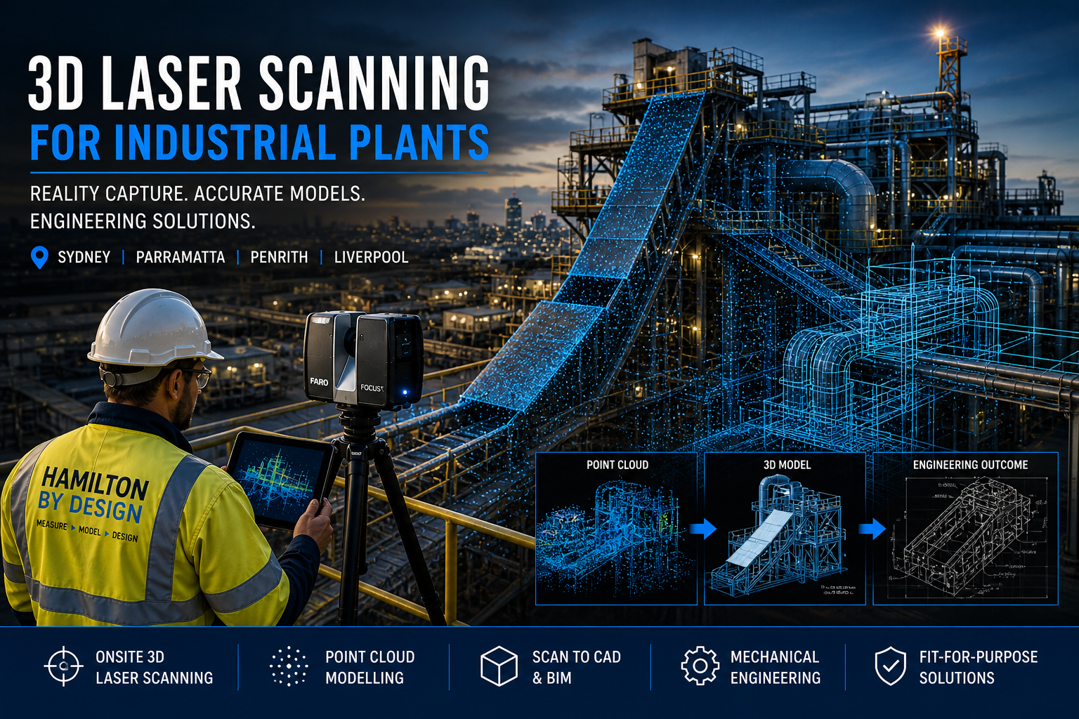
Industrial plant 3D laser scanning in Sydney showing engineer using LiDAR scanner with point cloud overlay and CAD modelling for engineering design

Point Cloud to CAD | Mechanical Engineering | Western Sydney Specialists

At Hamilton By Design, we provide engineering-grade 3D laser scanning for industrial plants, delivering accurate site data, detailed CAD models, and fit-for-purpose mechanical design solutions across Sydney, Parramatta, Penrith, and Liverpool.

Unlike typical 3D scanning companies, we are mechanical engineers first. That means every scan is captured with the end goal in mind โ€” design, fabrication, and real-world application.


3D Laser Scanning Services (Sydney & Western Sydney)

We offer onsite and mobile 3D scanning services across:

  • Parramatta
  • Penrith
  • Liverpool
  • Greater Western Sydney

Our LiDAR scanning services are ideal for:

  • Industrial plants
  • Manufacturing facilities
  • Processing plants
  • Construction and building upgrades

If youโ€™re searching for a โ€œ3D scanning company near meโ€, we deliver fast, accurate, and engineering-ready results.

3D CAD Modelling Australia service banner for Hamilton By Design

From Point Cloud to CAD (Engineering-Ready Models)

Scanning is only the first step.

We convert scan data into:

  • Point cloud modelling
  • 3D CAD models (SolidWorks, STEP, Parasolid)
  • 2D AutoCAD drawings
  • Scan-to-BIM models

This allows for:

  • Accurate design modifications
  • Clash detection
  • Fabrication-ready outputs

Mechanical Engineering Services

Hamilton By Design provides full mechanical engineering support, including:

  • Process equipment design
  • Structural and mechanical upgrades
  • Preventative maintenance design
  • Fit-for-purpose engineering solutions

All work is aligned with relevant Australian Standards, including AS 4991 where applicable.


Mining & Bulk Handling (High-Value Applications)

We specialise in mining and bulk materials handling systems, including:

  • Coal chutes and transfer stations
  • Conveyor systems
  • Outbye mining infrastructure
  • Header transition chutes

Custom Design vs Off-the-Shelf

Off-the-shelf chute designs often lead to:

  • Poor fit
  • Increased wear
  • High maintenance costs

Our approach:

  • Scan existing plant conditions
  • Develop custom designs based on real data
  • Deliver solutions that reduce downtime and improve performance

Building & Construction Scanning

We also support:

  • Building scanning services
  • Construction site verification
  • Scan-to-BIM for refurbishment projects

Ideal for commercial, industrial, and infrastructure upgrades.


Industries We Support

  • Industrial plants
  • Manufacturing facilities
  • Food processing plants
  • Mining and bulk handling
  • Construction and infrastructure

Locations We Service

We provide 3D laser scanning and engineering services across:

Sydney
Parramatta
Penrith
Liverpool
Western Sydney

With project capability across NSW and Australia.


Common Questions

What are the best 3D scanning platforms?

We use industry-leading LiDAR systems such as FARO and Leica. However, the real value comes from how the data is used in engineering design.


3D LiDAR scanning and 3D modelling service button โ€” laser scanner capturing a point cloud for engineering and CAD modelling
Mechanical engineering services

Do I need scan-to-CAD or just scanning?

Most industrial projects require CAD models and engineering input โ€” not just raw scan data.


Who provides professional 3D scanning near me?

Engineering-led companies like Hamilton By Design provide usable outcomes, not just visual data.


Hamilton By Design logo displayed on a blue tilted rectangle with a grey gradient background

Get Started

If you need accurate site data, modelling, or engineering support for an industrial project, contact Hamilton By Design today.


3D Scanning Sydney banner promoting engineering-grade 3D laser scanning, LiDAR scanning, and reality capture services by Hamilton By Design.
Mechanical Engineering Sydney banner with white text on a blue background representing Hamilton By Design's mechanical engineering services in Sydney.
Mechanical Drafting and 3D Modelling Sydney banner highlighting Hamilton By Design's CAD drafting, 3D modelling, and engineering design services in Sydney.

Mechanical Engineering | Structural Engineering


Hamilton By Design provides engineering-led 3D scanning, LiDAR scanning, mechanical engineering and digital engineering services throughout Sydney and Greater Sydney.

Explore our related Sydney services:


  • 3D Scanning Sydney โ€“ Engineering-grade terrestrial laser scanning, as-built surveys and point cloud capture for industrial, infrastructure and commercial projects.
  • Reality Capture Sydney โ€“ High-accuracy reality capture, digital twins, asset documentation and engineering-grade site verification.
  • Scan to CAD Sydney โ€“ Convert point cloud data into AutoCAD, SolidWorks, Inventor and other engineering-ready CAD deliverables.
  • Point Cloud Modelling Sydney โ€“ Engineering-grade point cloud processing, clash detection, as-built verification and 3D modelling.
  • Mechanical Engineering Sydney โ€“ Mechanical design, plant upgrades, materials handling systems, conveyors, chutes, platforms and engineering support.
  • Structural Drafting Sydney โ€“ Structural steel drafting, fabrication drawings, GA drawings, workshop detailing and as-built documentation.

Hamilton By Design supports projects throughout Sydney CBD, Parramatta, Liverpool, Penrith, Blacktown, Chatswood, Alexandria, Mascot, Newcastle and the Central Coast.


Blue banner graphic displaying the text "Point Cloud to CAD - Australia" in large white lettering, representing point cloud processing, scan-to-CAD conversion and digital engineering services across Australia.
Blue banner graphic displaying the text "Scan to CAD Sydney" in large white lettering, representing engineering-led point cloud to CAD conversion, LiDAR scanning and digital engineering services in Sydney.
Blue banner graphic displaying the text "Reality Capture Sydney - CBD" in large white lettering, representing engineering-led reality capture, LiDAR scanning and digital engineering services within Sydney CBD commercial buildings and infrastructure.
3D LiDAR Scanning Darwin for engineering surveys, laser scanning, reality capture and point cloud modelling services
3D LiDAR Scanning Australia engineering services for laser scanning, reality capture, scan-to-CAD, Scan-to-BIM and as-built documentation across Australia
3D LiDAR scanning services on the Central Coast providing engineering-grade laser scanning, point cloud capture, scan-to-CAD modelling and industrial reality capture for infrastructure and industrial projects.

AI Needs a Body โ€“ Why Point Cloud Data Powers the Next Generation of Engineering

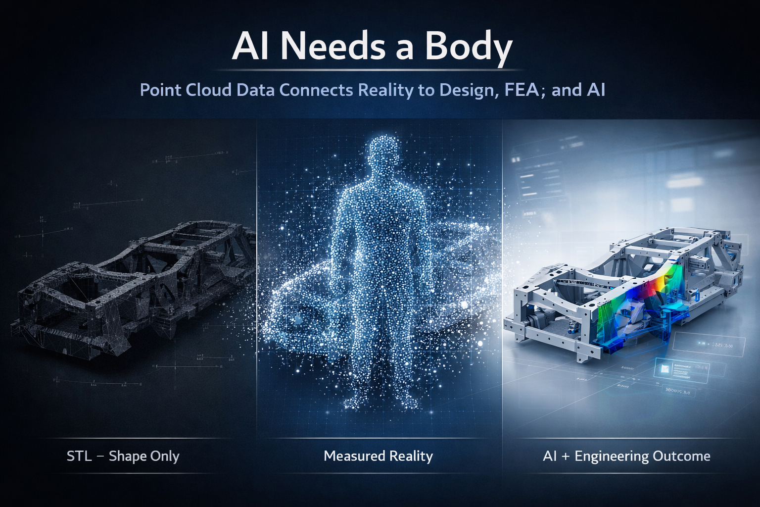
AI needs a body concept showing STL mesh, point cloud data, and CAD model with FEA for engineering workflow

Engineering is entering a new phase.

Artificial intelligence is being integrated into design platforms, automation is accelerating workflows, and digital engineering environments are becoming more connected than ever before. Tools such as SolidWorks are now introducing AI assistants like AURA, LEO, and Marie, promising smarter design, faster modelling, and improved decision-making.

But there is a fundamental issue that is often overlooked:

AI cannot design, validate, or optimise anything without a physical reference.

AI needs a body.

And in engineering, that body is real-world, measurable data.

3D point cloud scanning provides that foundation.


3D LiDAR scanning and 3D modelling service button โ€” laser scanner capturing a point cloud for engineering and CAD modelling
Mechanical engineering services

Gen 1, Gen 2, Gen 3 โ€“ The Evolution of Engineering

Engineering workflows can be broadly understood in three stages: Gen 1, Gen 2, and Gen 3.

Gen 1 was manual. Tape measures, site sketches, and experience-driven decisions formed the basis of design. While effective for its time, it relied heavily on interpretation and often resulted in rework due to incomplete data.

Gen 2 introduced CAD platforms such as SolidWorks, Autodesk Inventor, Autodesk Fusion, and Onshape. This enabled parametric modelling, faster iteration, and improved documentation. However, Gen 2 introduced a new problemโ€”designs were often disconnected from reality. Models were built based on assumptions, outdated drawings, or incomplete site data.

Even when scanning was introduced, the workflow often stopped at STL or OBJ files. These formats are visual representations only. They are static, faceted, and lack the structure required for engineering.

Gen 3 represents the shift to reality-based engineering. This is where point cloud scanning, CAD, FEA, AI, and lifecycle management systems all connect. The key difference is that models are no longer based on assumptionsโ€”they are derived from measured reality.


The Problem With STL Workflows

STL files are commonly produced by handheld or metrology-grade scanners. They are easy to generate and provide a visually accurate representation of a component.

However, an STL file is a triangulated mesh. It contains no features, no relationships, and no design intent. It is a surface approximation made up of flat facets.

This creates a major limitation.

An STL file can show what something looks like, but it cannot define how it functions, how it should be modified, or how it should be manufactured.


Why FEA on STL Is Not Best Practice

It is technically possible to run Finite Element Analysis (FEA) on an STL file, but it is not considered best practice.

The reasons are straightforward.

The geometry is not true. Surfaces are faceted, holes are not perfect circles, and edges are broken into triangles. This makes it difficult to apply loads and boundary conditions accurately.

Because the STL is already a mesh, FEA introduces a second mesh on top of it. This reduces control over element quality and can affect convergence and accuracy.

Most importantly, the results are based on an approximation rather than engineered geometry.

You are analysing a surface representation, not a design.

For engineering decisions, this creates risk. Results become difficult to verify, defend, or repeat.


AI Has the Same Limitation

AI assistants such as AURA, LEO, and Marie are designed to work inside CAD environments. They rely on structured, parametric data to assist with modelling, optimisation, and decision-making.

They are highly effective when working with:

  • Defined features
  • Parametric relationships
  • Clean geometry

But when given an STL file, AI faces the same problem as the engineer.

There are no features to interpret, no constraints to follow, and no design intent to understand. The data is simply a collection of triangles.

As a result:

AI cannot meaningfully design or optimise from an STL file.

It can attempt to approximate geometry, but it cannot guarantee accuracy, intent, or engineering reliability.


AI Needs a Body

AI is often described as the brain of the future engineering workflow.

But a brain alone is not enough.

Without a body:

  • There is no spatial context
  • No physical reference
  • No connection to reality

In engineering, the body is the physical asset captured in digital form.

This is where point cloud scanning becomes critical.


Point Cloud โ€“ The Body for Engineering and AI

Point cloud data captures millions of measured points in three-dimensional space. Each point represents a real-world coordinate.

This provides:

  • True geometry
  • Accurate spatial relationships
  • Complete environmental context

Unlike STL files, point clouds are not simplified or interpreted. They represent measured reality.

From this data, engineers can:

  • Extract accurate dimensions
  • Fit planes, cylinders, and features
  • Build parametric CAD models
  • Maintain traceability back to the original scan

This creates a reliable foundation for both engineering and AI.


The Correct Engineering Workflow

A robust, engineering-grade workflow follows a clear sequence:

Scan โ†’ Point Cloud โ†’ CAD Model โ†’ FEA โ†’ AI โ†’ Engineering Outcome

Each step adds value.

The scan captures reality.
The point cloud preserves it.
The CAD model structures it.
FEA validates it.
AI enhances it.

Without the point cloud, the entire process loses its connection to reality.


Vehicle Chassis Example

Consider the development or modification of a vehicle chassis.

Using an STL-based workflow, the process typically involves rebuilding geometry from a mesh, applying FEA to an approximation, and attempting to optimise the design without a reliable reference. This introduces risk in alignment, load paths, and final fitment.

Using a point cloud-based workflow, the chassis is scanned and modelled directly from measured data. FEA is applied to true geometry, and AI tools such as AURA, LEO, and Marie can assist in refining and optimising the design.

The result is accurate, repeatable, and ready for manufacturing.


Digital Twin, PLM, and the 3D Environment

Point cloud data also supports broader engineering systems, including Digital Mock-Up (DMU), Product Data Management (PDM), and Product Lifecycle Management (PLM).

These systems rely on a single source of truth.

Point cloud data provides that truth by ensuring alignment between the digital model and the physical asset.

This enables:

  • Lifecycle tracking
  • Design validation
  • Ongoing updates and modifications

It also supports Digital Twin environments, where the physical and digital worlds remain connected over time.


Manufacturing in Australia

For manufacturing, accuracy is critical.

Point cloud-driven workflows ensure that:

  • Components fit as intended
  • Drawings reflect real-world conditions
  • Rework is minimised
  • Fabrication is efficient

This is particularly important for local manufacturing in Australia, where precision and reliability directly impact cost and delivery.


The Bottom Line

It is not best practice to run FEA on an STL file. It is not effective to design from an STL file. And it is unrealistic to expect AI to compensate for poor input data.

STL files provide a visual reference, but they do not provide a foundation for engineering.

AI is a powerful tool, but it cannot operate without accurate, structured data.

AI cannot fix a workflow that starts with the wrong data.


Final Thought

Engineering is evolving.

Gen 1 was manual.
Gen 2 was digital.
Gen 3 is reality-based and AI-assisted.

AI is not the starting point. Data is.

And in modern engineering:

AI needs a body.
Point cloud scanning is that body.

Our Clients

Finite Element Analysis (FEA) engineering simulation button
Mechanical engineering services

Chain of Custody in LiDAR Scanning | Data Governance with 3DEXPERIENCE

Chain of Custody, Data Governance, and Engineering-Grade LiDAR Workflows

Why Chain of Custody Matters in Reality Capture

As LiDAR scanning technology becomes more widely used across mining, manufacturing, and infrastructure, the role of scan data is changing.

Point clouds are no longer just visual references โ€” they are increasingly relied upon for:

  • Engineering design decisions
  • Asset verification
  • Contractor coordination
  • Insurance and compliance
  • Legal and dispute resolution

In this environment, the question is no longer โ€œDo you have a scan?โ€
It is:

โ€œCan this data be trusted?โ€


The Problem with Traditional Scanning Workflows

Many scanning providers still operate with a simple delivery model:

  • Capture data
  • Process it
  • Export a file
  • Send via Dropbox or USB

At that point:

  • File versions are uncontrolled
  • Edits are not tracked
  • Data integrity cannot be verified
  • There is no audit trail

For engineering, this creates risk.
For legal or contractual matters, it can make the data unusable.


3D LiDAR scanning and 3D modelling service button โ€” laser scanner capturing a point cloud for engineering and CAD modelling
Mechanical engineering services

What is Chain of Custody in LiDAR Scanning?

Chain of custody refers to the complete, traceable record of how data is handled, from capture through to final use.

For LiDAR scanning, this includes:

  • Who captured the data
  • When and where it was captured
  • Equipment used and calibration status
  • Processing steps and software workflows
  • File versions and revisions
  • Who has accessed or modified the data

A properly managed chain of custody ensures that:

  • Data is authentic
  • Data is unchanged or changes are recorded
  • Data can be defended if challenged

Introducing Data Governance Through the 3DEXPERIENCE Platform

At Hamilton By Design, LiDAR scanning is not treated as a standalone service.
It is integrated into a controlled engineering environment using the 3DEXPERIENCE platform.

This shifts the workflow from:

  • File-based delivery
    to
  • Managed digital asset lifecycle

How LiDAR and 3DEXPERIENCE Work Together

1. Controlled Data Capture

  • Engineering-led scanning methodologies
  • Defined scan plans and coverage
  • Documented site conditions and limitations

2. Structured Data Processing

  • Registered point clouds with documented workflows
  • Export formats aligned to downstream engineering use
  • Verification of alignment and accuracy

3. Centralised Data Storage

  • All scan data stored in a secure, managed environment
  • No reliance on uncontrolled file sharing
  • Single source of truth for all stakeholders

4. Revision Control and Traceability

  • Every model, drawing, and dataset is version-controlled
  • Changes are tracked and attributable
  • Previous revisions remain accessible

5. Multi-User Collaboration

  • Engineers, designers, and contractors access the same dataset
  • No duplication of files
  • Reduced risk of working on outdated information

6. Audit-Ready Data

  • Full history of data handling and modification
  • Clear documentation of methodology
  • Suitable for compliance, contractual, and legal review

Engineering Outcomes, Not Just Scan Data

The integration of LiDAR with the 3DEXPERIENCE platform enables a shift from raw data delivery to engineering-ready outputs:

  • Point clouds linked directly to CAD models
  • Scan-to-SolidWorks workflows for fabrication
  • Drawings developed within a controlled revision environment
  • Digital twins that evolve with the asset

This ensures that the data is not only accurate โ€” it is usable and maintainable over time.


Reducing Risk Across the Asset Lifecycle

By combining chain of custody principles with structured data governance, Hamilton By Design helps clients:

  • Reduce rework during construction and shutdowns
  • Improve confidence in design decisions
  • Maintain accurate as-built records
  • Support compliance and audit requirements
  • Provide defensible data where disputes arise

The Future of Reality Capture

As industries move toward digital twins and data-driven decision-making, unmanaged scan files will become increasingly inadequate.

The future is:

  • Controlled
  • Traceable
  • Collaborative
  • Defensible

Summary

LiDAR scanning provides the data.
Chain of custody ensures it can be trusted.
Data governance ensures it remains valuable.

Hamilton By Design delivers all three โ€” combining engineering-led reality capture with structured digital environments to support the full asset lifecycle.

Our Clients

Name
Would you like us to arrange a phone consultation for you?
Address
3D CAD Modelling Australia service banner for Hamilton By Design
Australian Drafting logo featuring bold white text reading "Australian Drafting" centred on a blue rounded rectangle background.
Engineering Governance title graphic featuring bold white text reading "Engineering Governance" centred on a blue rounded rectangle background.
Mechanical, Structural & Pipework Drafting service banner by Hamilton By Design featuring white text on a blue background.
Mechanical engineering services
Blue rounded button with the text โ€œSolidWorks Designโ€ in white.
Finite Element Analysis (FEA) engineering simulation button
3D LiDAR Scanning Darwin for engineering surveys, laser scanning, reality capture and point cloud modelling services
3D LiDAR Scanning Australia engineering services for laser scanning, reality capture, scan-to-CAD, Scan-to-BIM and as-built documentation across Australia
3D LiDAR scanning services on the Central Coast providing engineering-grade laser scanning, point cloud capture, scan-to-CAD modelling and industrial reality capture for infrastructure and industrial projects.
3D LiDAR Scanning Perth for engineering surveys, laser scanning, reality capture and point cloud modelling services
3D LiDAR Scanning Sydney for engineering surveys, laser scanning, reality capture and point cloud modelling services
3D LiDAR Scanning Brisbane for engineering surveys, laser scanning, reality capture and point cloud modelling services
3D LiDAR Scanning Canberra for engineering surveys, laser scanning, reality capture and point cloud modelling services
3D LiDAR Scanning Newcastle for engineering surveys, laser scanning, reality capture and point cloud modelling services
3D LiDAR Scanning Adelaide for engineering surveys, laser scanning, reality capture and point cloud modelling services

Digital Engineering for Conveyor and Materials Handling Systems

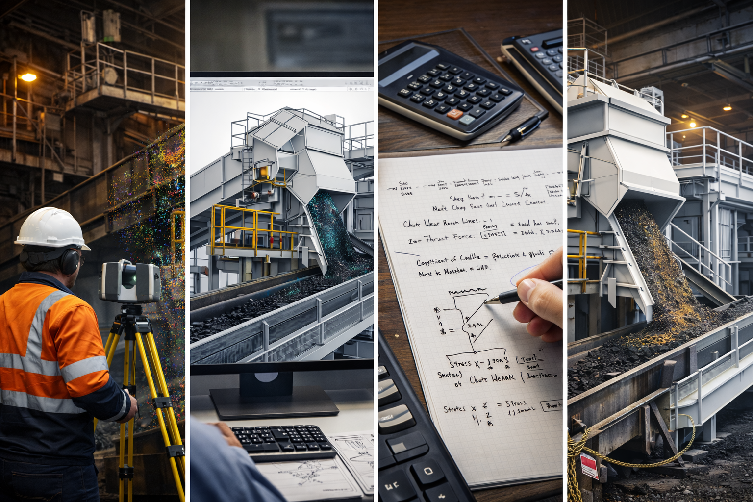
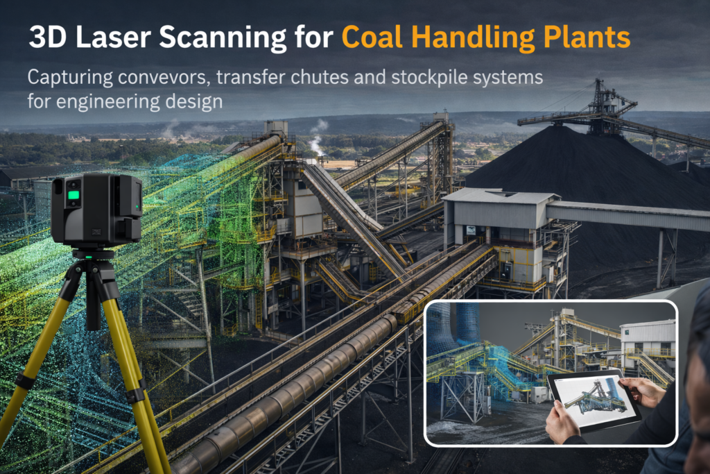
Mining conveyor engineering workflow showing laser scanning, 3D modelling, engineering calculations and installation of a transfer chute.

Mining Conveyor Engineering Design | Digital Engineering for Materials Handling Systems

Conveyor systems form the backbone of many mining and industrial processing operations. From coal handling plants and mineral processing facilities to port loading infrastructure, conveyors and transfer systems move large volumes of material continuously throughout the plant.

As mining infrastructure becomes more complex, engineering teams increasingly rely on digital engineering workflows to design, upgrade and maintain conveyor systems. These workflows combine laser scanning, point cloud modelling and 3D engineering design to improve accuracy and reduce project risk.

Digital engineering allows engineers to capture existing plant conditions, develop accurate engineering models, and design modifications with confidence before construction or shutdown activities begin.


The Role of Conveyor Engineering in Mining Operations

Conveyors transport bulk materials between key processing areas such as crushers, screens, stockpiles and ship loading systems. Because these systems operate continuously, even small design issues can cause major operational problems.

Common engineering challenges include:

  • transfer point blockages
  • excessive belt wear
  • material spillage and dust generation
  • structural fatigue in conveyor galleries
  • poor maintenance access

Effective mining conveyor engineering design focuses on improving reliability, safety and maintainability while ensuring the system integrates correctly with the surrounding plant infrastructure.

For further information on mechanical engineering services supporting mining operations see:
โžก Hamilton By Design Co. โ€“


Using Digital Models to Improve Conveyor Design

Traditional conveyor design often relied on outdated plant drawings or manual site measurements. However, many mining facilities have undergone decades of modifications, meaning the original design documentation no longer reflects the actual plant layout.

Modern engineering teams now use laser scanning and point cloud modelling to capture accurate representations of plant infrastructure.

These digital datasets allow engineers to develop detailed models of:

  • conveyor structures and galleries
  • transfer chutes and material flow points
  • structural steel platforms and walkways
  • access ladders and maintenance areas
  • surrounding plant equipment

By converting scan data into engineering models, designers can evaluate system upgrades with far greater accuracy.

Learn more about how scan data is converted into engineering models here:


Engineering Conveyor Upgrades During Shutdowns

Many conveyor upgrades are implemented during planned shutdowns where plant equipment must be isolated for maintenance or replacement.

During these shutdown windows engineers may install:

  • replacement transfer chutes
  • new conveyor sections
  • structural modifications
  • upgraded dust control systems
  • improved maintenance access platforms

Because shutdown windows are often limited to a few days, engineering design must be completed and validated before work begins.

Digital plant models allow engineers to confirm equipment clearances, identify potential clashes and develop fabrication drawings prior to the shutdown period.

More information on shutdown engineering preparation can be found here:


Transfer Chute Design in Materials Handling Systems

Transfer chutes are critical components in conveyor systems because they control the flow of material between conveyors or processing equipment.

Poor chute design can lead to:

  • material buildup and blockages
  • uneven belt loading
  • excessive dust generation
  • increased wear on belts and liners

Using digital plant models, engineers can analyse the surrounding infrastructure and design chute geometries that improve material flow and reduce maintenance issues.

Further insights into chute engineering design are available here:
โžก https://chutesandtransferstations.blogspot.com/2025/07/designing-for-durability-chutes.html


Hamilton By Design logo displayed on a blue tilted rectangle with a grey gradient background

3D LiDAR scanning and 3D modelling service button โ€” laser scanner capturing a point cloud for engineering and CAD modelling
Mechanical engineering services

Benefits of Digital Engineering for Materials Handling Systems

Digital engineering workflows provide several key advantages for mining infrastructure projects:

Improved design accuracy
Accurate plant models reduce errors caused by outdated drawings or incomplete measurements.

Reduced installation risk
Engineering models allow equipment fit-up to be verified before fabrication and installation.

Faster project delivery
Engineering teams can plan upgrades more efficiently using digital plant models.

Improved maintenance planning
Digital models support better access design and long-term asset management.


The Future of Conveyor Engineering

As mining operations continue to adopt digital engineering technologies, the design and maintenance of conveyor systems is becoming increasingly data-driven.

Technologies such as:

  • 3D laser scanning
  • point cloud modelling
  • digital twins
  • engineering simulation

are helping engineers develop more reliable materials handling systems and reduce operational downtime.

For mining operators planning plant upgrades or shutdown maintenance, integrating digital engineering into conveyor design workflows is becoming an essential part of modern infrastructure planning.

3D laser scanning of coal handling plant conveyors transfer chutes and stockpile systems for engineering design

Name
Would you like us to arrange a phone consultation for you?
Address
3D CAD Modelling Australia service banner for Hamilton By Design
Australian Drafting logo featuring bold white text reading "Australian Drafting" centred on a blue rounded rectangle background.
Engineering Governance title graphic featuring bold white text reading "Engineering Governance" centred on a blue rounded rectangle background.
Mechanical, Structural & Pipework Drafting service banner by Hamilton By Design featuring white text on a blue background.
Mechanical engineering services
Blue rounded button with the text โ€œSolidWorks Designโ€ in white.
Finite Element Analysis (FEA) engineering simulation button
3D LiDAR Scanning Darwin for engineering surveys, laser scanning, reality capture and point cloud modelling services
3D LiDAR Scanning Australia engineering services for laser scanning, reality capture, scan-to-CAD, Scan-to-BIM and as-built documentation across Australia
3D LiDAR scanning services on the Central Coast providing engineering-grade laser scanning, point cloud capture, scan-to-CAD modelling and industrial reality capture for infrastructure and industrial projects.
3D LiDAR Scanning Perth for engineering surveys, laser scanning, reality capture and point cloud modelling services
3D LiDAR Scanning Sydney for engineering surveys, laser scanning, reality capture and point cloud modelling services
3D LiDAR Scanning Brisbane for engineering surveys, laser scanning, reality capture and point cloud modelling services
3D LiDAR Scanning Canberra for engineering surveys, laser scanning, reality capture and point cloud modelling services
3D LiDAR Scanning Newcastle for engineering surveys, laser scanning, reality capture and point cloud modelling services
3D LiDAR Scanning Adelaide for engineering surveys, laser scanning, reality capture and point cloud modelling services

3D LiDAR Construction Scanning

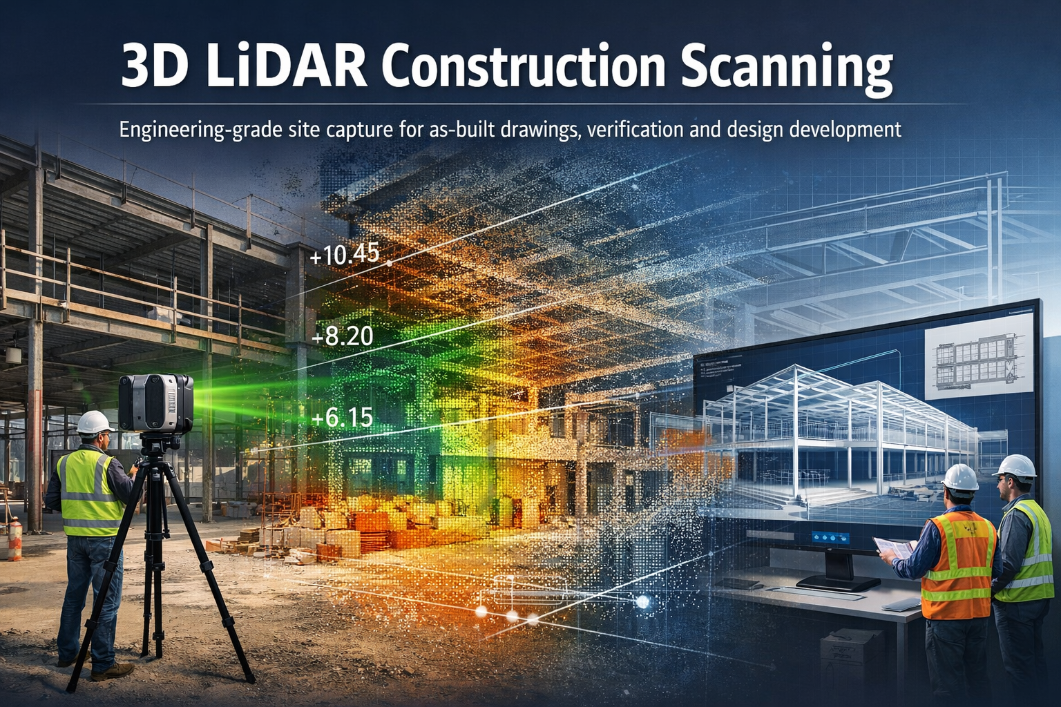
3D LiDAR construction scanning capturing a building site and converting it into a point cloud and engineering model

Engineering-Grade Reality Capture for Construction Projects

3D LiDAR construction scanning is transforming how engineers, builders, and project teams capture and understand existing site conditions.

Structural steel I-beam bolted connection with column in isometric view.

Hamilton By Design provides engineering-grade 3D LiDAR scanning services for construction projects, helping capture accurate digital models of buildings, structures, and construction sites before, during, and after construction works. Using advanced laser scanning technology, millions of precise measurements can be captured within minutes to produce detailed 3D point clouds and digital models of real-world structures. These models provide reliable information for planning, design, verification and as-built documentation.

Our scanning workflows allow project teams to move from existing construction conditions to accurate engineering models, helping reduce uncertainty and improve project outcomes.


What is 3D LiDAR Construction Scanning?

3D LiDAR scanning uses laser-based sensors to measure distances between the scanner and surrounding surfaces. The system records millions of measurements which form a point cloud representing the exact geometry of the construction environment.

These point clouds create highly detailed digital representations of buildings, infrastructure and construction sites that can be measured, analysed and modelled in engineering software.

For construction projects this provides a powerful way to:

  • capture existing building geometry
  • verify construction progress
  • generate accurate as-built drawings
  • support design coordination
  • analyse levels, clearances and spatial constraints

Modern LiDAR scanning allows engineers to capture entire buildings and construction sites quickly and accurately, creating reliable digital data for planning and engineering workflows.


Applications of LiDAR Scanning in Construction

3D LiDAR scanning supports a wide range of construction and engineering tasks.

As-Built Documentation

Construction drawings often become outdated as projects evolve. LiDAR scanning provides accurate as-built documentation of structures, capturing the exact conditions present on site.

These datasets can be used to generate:

  • floor plans
  • elevations
  • cross sections
  • building models
  • digital twins of facilities

Learn more:


Construction Verification and Quality Control

Scanning can be used during construction to verify that structures match the design intent.

Point cloud data can be compared against design models to identify:

  • structural deviations
  • alignment issues
  • level variations
  • installation conflicts

This helps project teams identify problems early before they become costly construction errors.


Renovation and Refurbishment Projects

Older buildings often have incomplete or inaccurate drawings.

3D LiDAR scanning provides a reliable way to capture existing conditions before renovation works begin. Engineers and designers can then develop new designs directly from the scanned data.

This reduces risk and ensures that new components fit correctly within existing structures.

Related page:


Structural and Architectural Analysis

Construction scanning can also be used to analyse structural geometry and building profiles, including:

  • roof profiles and screed levels
  • slab levels and floor flatness
  • faรงade alignment
  • structural steel positioning
  • drainage and fall verification

These measurements allow engineers to identify geometry problems early and support accurate construction planning.


The Scan to Engineering Model Workflow

Hamilton By Design integrates LiDAR scanning with engineering modelling workflows.

Typical project workflow:

Existing Construction Site
โ†“
3D LiDAR Scanning
โ†“
Point Cloud Processing
โ†“
Scan-to-CAD Modelling
โ†“
Engineering Analysis and Design

This workflow allows engineers to work from accurate digital representations of real-world conditions, reducing the need for repeated site visits and manual measurements.


Benefits of LiDAR Scanning for Construction Projects

3D LiDAR scanning provides several advantages compared with traditional measurement methods.

Accurate Site Data

Laser scanners capture millions of measurements quickly, producing detailed datasets that accurately represent site conditions.

Reduced Project Risk

Accurate site data reduces the risk of design errors, construction conflicts and unexpected site conditions.

Faster Site Surveys

Entire buildings and construction areas can be captured in a short time, reducing the need for multiple survey visits.

Improved Project Coordination

Point cloud data can be shared between architects, engineers and contractors, ensuring everyone works from the same information.

Support for Digital Engineering Workflows

LiDAR scanning supports modern design processes such as:

  • scan-to-CAD modelling
  • digital twins
  • BIM coordination
  • construction verification

Engineering-Grade 3D Laser Scanning

Blue 3D LiDAR scanner icon on a tripod with scanning waves

Hamilton By Design provides professional scanning services focused on engineering and industrial applications, not just visualisation.

Our scanning workflows support projects across:

  • industrial facilities
  • infrastructure projects
  • buildings and structures
  • construction sites
  • mechanical and structural engineering projects

Learn more about our scanning capabilities:


When is LiDAR Construction Scanning Most Valuable?

3D scanning is particularly useful in situations where accurate geometry is critical.

Examples include:

  • building renovations
  • structural modifications
  • plant installations within buildings
  • roof level and drainage analysis
  • verifying construction tolerances
  • documenting existing conditions before construction

In many cases the cost of scanning is small compared with the potential cost of construction errors.


Hamilton By Design logo displayed on a blue tilted rectangle with a grey gradient background
3D LiDAR scanning and 3D modelling service button โ€” laser scanner capturing a point cloud for engineering and CAD modelling
Mechanical engineering services

Talk With Hamilton By Design

If you require 3D LiDAR construction scanning for engineering or building projects, Hamilton By Design can help capture accurate digital models of your site.

Our team specialises in scanning workflows that support engineering analysis, design development and construction planning.

Contact Hamilton By Design to discuss your project requirements.

Name
Would you like us to arrange a phone consultation for you?
Address
3D CAD Modelling Australia service banner for Hamilton By Design

Mechanical Engineering | Structural Engineering