Scan-to-CAD vs Traditional Design Workflows | Which Approach Delivers Better Engineering Outcomes?

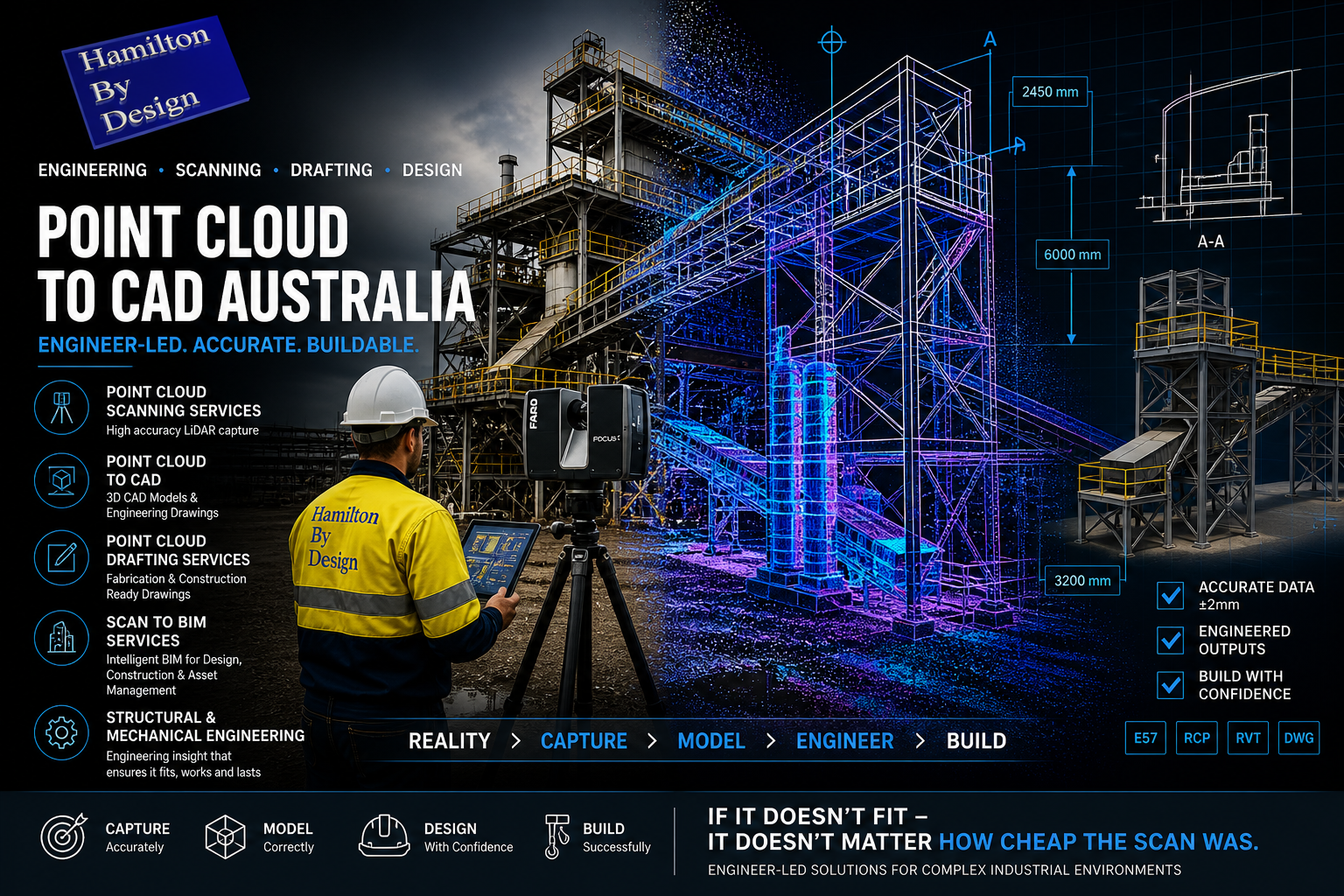
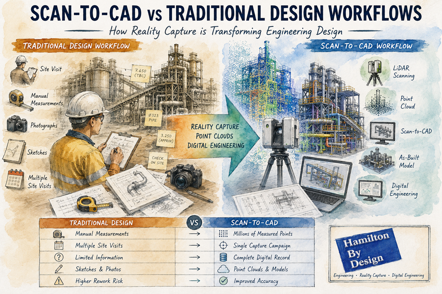
Scan-to-CAD vs traditional design workflows infographic showing LiDAR scanning, point cloud modelling, reality capture and digital engineering for industrial plant design and as-built documentation.

Scan-to-CAD vs Traditional Design Workflows: How Reality Capture is Transforming Engineering Design

For decades, engineering and drafting companies have relied on traditional design workflows to create new assets, modify existing facilities and develop construction documentation. These methods typically involve site visits, manual measurements, photographs, sketches and extensive assumptions about existing conditions.

While traditional design processes have successfully delivered countless projects, modern reality capture technologies are changing how engineering data is collected and utilised.

The introduction of terrestrial LiDAR scanning, engineering-grade reality capture and point cloud modelling has given design companies access to highly accurate representations of existing facilities. Rather than starting with assumptions and limited measurements, engineers can now begin with a digital copy of reality.

This approach is commonly known as Scan-to-CAD.

At Hamilton By Design, we have seen first-hand how Scan-to-CAD workflows can improve project accuracy, reduce site visits and provide better information for engineering decision-making. However, traditional design methods still have an important role to play.

The key is understanding where each approach provides the greatest value.


What is a Traditional Design Workflow?

Traditional design workflows generally begin with a site inspection and manual data collection process.

An engineer, designer or draftsperson visits the facility and records information such as:

  • Dimensions
  • Levels
  • Equipment locations
  • Structural arrangements
  • Pipe routing
  • Building layouts
  • Photographs
  • Sketches

The collected information is then used to develop drawings and 3D models.

A typical workflow may include:

  1. Site visit
  2. Manual measurements
  3. Photographic survey
  4. Sketch preparation
  5. CAD model creation
  6. Design development
  7. Drawing production
  8. Construction issue

This process has been the backbone of engineering design for many years.


Challenges with Traditional Design Methods

Although effective, traditional workflows present several challenges.

Limited Data Collection

No matter how experienced the survey team is, it is impossible to measure everything.

Often only dimensions considered important at the time are collected.

If additional information is required later, another site visit may be necessary.

Human Error

Manual measurements introduce opportunities for error.

Common issues include:

  • Incorrect dimensions
  • Missed measurements
  • Recording errors
  • Inconsistent datum references

These errors can propagate throughout the project.

Access Restrictions

Industrial facilities often contain:

  • Confined spaces
  • Elevated structures
  • Operational equipment
  • Hazardous environments

Obtaining measurements in these areas can be difficult and expensive.

Multiple Site Visits

Many projects require repeated visits to verify dimensions and resolve discrepancies.

This increases:

  • Project costs
  • Travel expenses
  • Programme duration

What is Scan-to-CAD?

Scan-to-CAD is the process of using reality capture technologies to create engineering drawings and models.

The workflow begins with a terrestrial LiDAR scan of the facility.

Millions or billions of measured points are captured to create a highly detailed point cloud.

The point cloud then becomes the foundation for:

  • CAD models
  • BIM models
  • General arrangement drawings
  • Structural models
  • Pipework layouts
  • Reverse engineering projects
  • Asset documentation

Rather than manually measuring selected features, Scan-to-CAD captures the entire environment.


How Scan-to-CAD Works

Step 1 โ€“ Reality Capture

A LiDAR scanner records the existing facility.

This may include:

  • Buildings
  • Process plants
  • Pipework
  • Conveyors
  • Tanks
  • Structural steel
  • Mechanical equipment

Step 2 โ€“ Point Cloud Registration

Individual scans are combined into a unified coordinate system.

The result is a complete digital representation of the site.

Step 3 โ€“ Engineering Review

Engineers review the point cloud and determine project requirements.

Step 4 โ€“ CAD Modelling

Relevant assets are modelled from the point cloud.

Outputs may include:

  • 2D drawings
  • 3D CAD models
  • BIM models
  • Fabrication drawings
  • Construction documentation

Step 5 โ€“ Design Development

The design team develops modifications directly against existing conditions.


Comparing Scan-to-CAD and Traditional Design Workflows

Accuracy

Traditional Workflow

Accuracy depends on:

  • Measurement methods
  • Survey coverage
  • Site conditions
  • Human interpretation

Typically, only selected dimensions are recorded.

Scan-to-CAD

Millions of measured points create a detailed digital representation.

Engineering-grade terrestrial LiDAR scanning can provide highly accurate spatial information across entire facilities.

Winner: Scan-to-CAD


Site Time

Traditional Workflow

Complex facilities may require several site visits.

Scan-to-CAD

Most information is captured during a single scanning campaign.

Winner: Scan-to-CAD


Data Availability

Traditional Workflow

Only measured dimensions are available.

Scan-to-CAD

The entire captured environment remains available for future reference.

Winner: Scan-to-CAD


Upfront Cost

Traditional Workflow

Lower initial survey costs.

Scan-to-CAD

Requires specialised scanning equipment and processing.

Winner: Traditional Workflow


Long-Term Value

Traditional Workflow

Information is often project-specific.

Scan-to-CAD

Point clouds become long-term digital assets.

Winner: Scan-to-CAD


Why Design Companies Are Adopting Scan-to-CAD

Increasingly, engineering consultancies and drafting companies are integrating reality capture into their workflows.

Benefits include:

Reduced Rework

Designs can be developed against actual site conditions.

Improved Clash Detection

Existing assets can be modelled accurately.

Better Stakeholder Communication

Point clouds and digital models improve project visualisation.

Enhanced Project Planning

Engineers can assess access and constructability earlier.

Faster Design Iterations

Additional measurements are often available without returning to site.


Applications Across Industries

Mining

Mining facilities contain extensive:

  • Conveyors
  • Chutes
  • Crushers
  • Tanks
  • Pipework

Scan-to-CAD can significantly improve brownfield modification projects.

Manufacturing

Production facilities frequently evolve over time.

Reality capture provides accurate documentation of current conditions.

Water and Wastewater

Pump stations and treatment plants often contain complex mechanical layouts.

Scan-to-CAD improves upgrade planning and documentation.

Commercial Buildings

Architects and engineers can generate accurate as-built documentation.

Energy

Power stations and industrial utilities benefit from detailed digital asset records.


When Traditional Workflows Still Make Sense

Despite the advantages of reality capture, traditional methods remain valuable.

Examples include:

Concept Design

Early-stage feasibility studies may not require detailed site data.

Greenfield Projects

When designing on vacant land, no existing assets exist to scan.

Small Modifications

Minor changes may not justify scanning costs.

Budget-Constrained Projects

Some projects require a lower-cost approach.

The most successful engineering organisations understand that both approaches have their place.


The Rise of AI-Assisted Scan-to-CAD

Artificial Intelligence is introducing new capabilities into reality capture workflows.

Emerging technologies can:

  • Identify pipework
  • Classify equipment
  • Recognise structural steel
  • Generate preliminary BIM models
  • Accelerate modelling workflows

Although engineering verification remains essential, AI-assisted modelling is expected to become increasingly common.


Digital Twins and Future Design Workflows

The future of engineering design is likely to combine:

  • Reality capture
  • Scan-to-CAD
  • Scan-to-BIM
  • Digital twins
  • Artificial intelligence
  • Cloud collaboration

Rather than creating drawings from limited measurements, engineering teams will increasingly work from comprehensive digital representations of existing assets.

This shift has the potential to improve project quality, reduce risk and accelerate project delivery.


How Hamilton By Design Supports Scan-to-CAD Projects

Hamilton By Design provides engineering-led reality capture and Scan-to-CAD services throughout Australia.

Our capabilities include:

  • Terrestrial LiDAR scanning
  • Engineering-grade reality capture
  • Point cloud registration
  • Scan-to-CAD
  • Scan-to-BIM
  • Reverse engineering
  • Mechanical design
  • Structural drafting
  • Asset documentation
  • Digital engineering support

We work across:

  • Mining
  • Manufacturing
  • Infrastructure
  • Energy
  • Commercial buildings
  • Water and wastewater

Our approach combines practical engineering experience with modern reality capture technology to deliver accurate and usable engineering information.


Hamilton By Design logo displayed on a blue tilted rectangle with a grey gradient background

Traditional design workflows have served the engineering industry well for decades and continue to play an important role in many projects.

However, the emergence of Scan-to-CAD workflows has fundamentally changed how existing facilities can be documented and modelled.

By capturing measured reality rather than relying solely on manual measurements, engineering teams gain access to more complete information, improved accuracy and greater flexibility throughout the design process.

For brownfield projects, industrial facilities and complex infrastructure, Scan-to-CAD is increasingly becoming the preferred method for developing accurate engineering deliverables.

Rather than replacing traditional design workflows, reality capture enhances them, providing engineers and designers with a richer foundation from which to make informed decisions.


Frequently Asked Questions (FAQ)

What is Scan-to-CAD?

Scan-to-CAD is the process of converting LiDAR scan data or point clouds into CAD drawings and 3D models. It allows engineers to develop designs using accurate representations of existing assets.

How accurate is Scan-to-CAD?

Accuracy depends on the scanning equipment and workflow used. Engineering-grade terrestrial LiDAR scanning can provide highly accurate spatial information suitable for engineering and drafting applications.

What industries benefit most from Scan-to-CAD?

Mining, manufacturing, infrastructure, energy, commercial buildings, water treatment facilities and industrial processing plants all benefit from Scan-to-CAD workflows.

Is Scan-to-CAD better than traditional surveying?

Both approaches have value. Scan-to-CAD generally provides more comprehensive site information, while traditional surveying may be appropriate for smaller or less complex projects.

Can point clouds be used directly in CAD software?

Yes. Many CAD platforms can reference point cloud data directly, allowing engineers to model against real-world measurements.

What is the difference between Scan-to-CAD and Scan-to-BIM?

Scan-to-CAD focuses on creating engineering drawings and CAD models, while Scan-to-BIM creates Building Information Models containing both geometry and asset information.

Does Scan-to-CAD reduce site visits?

In many cases, yes. Capturing comprehensive scan data can significantly reduce the need for repeat measurement visits.

Can AI automatically create CAD models from point clouds?

AI-assisted modelling tools are becoming increasingly capable, but engineering review and verification remain essential for accurate project outcomes.

What deliverables can be produced from a Scan-to-CAD project?

Deliverables may include point clouds, CAD models, BIM models, fabrication drawings, as-built drawings, general arrangement drawings and digital twin models.

Why choose Hamilton By Design for Scan-to-CAD projects?

Hamilton By Design combines engineering-led reality capture, practical industry experience and advanced digital engineering workflows to deliver accurate and usable engineering information for industrial and infrastructure projects throughout Australia.


Mechanical Engineering | Structural Engineering


3D LiDAR Scanning Darwin for engineering surveys, laser scanning, reality capture and point cloud modelling services
3D LiDAR Scanning Australia engineering services for laser scanning, reality capture, scan-to-CAD, Scan-to-BIM and as-built documentation across Australia
3D LiDAR scanning services on the Central Coast providing engineering-grade laser scanning, point cloud capture, scan-to-CAD modelling and industrial reality capture for infrastructure and industrial projects.
3D LiDAR Scanning Perth for engineering surveys, laser scanning, reality capture and point cloud modelling services
3D LiDAR Scanning Sydney for engineering surveys, laser scanning, reality capture and point cloud modelling services
3D LiDAR Scanning Brisbane for engineering surveys, laser scanning, reality capture and point cloud modelling services
3D LiDAR Scanning Canberra for engineering surveys, laser scanning, reality capture and point cloud modelling services
3D LiDAR Scanning Newcastle for engineering surveys, laser scanning, reality capture and point cloud modelling services
3D LiDAR Scanning Adelaide for engineering surveys, laser scanning, reality capture and point cloud modelling services

Automated Object Recognition from Point Clouds | AI-Assisted Scan-to-BIM Workflows

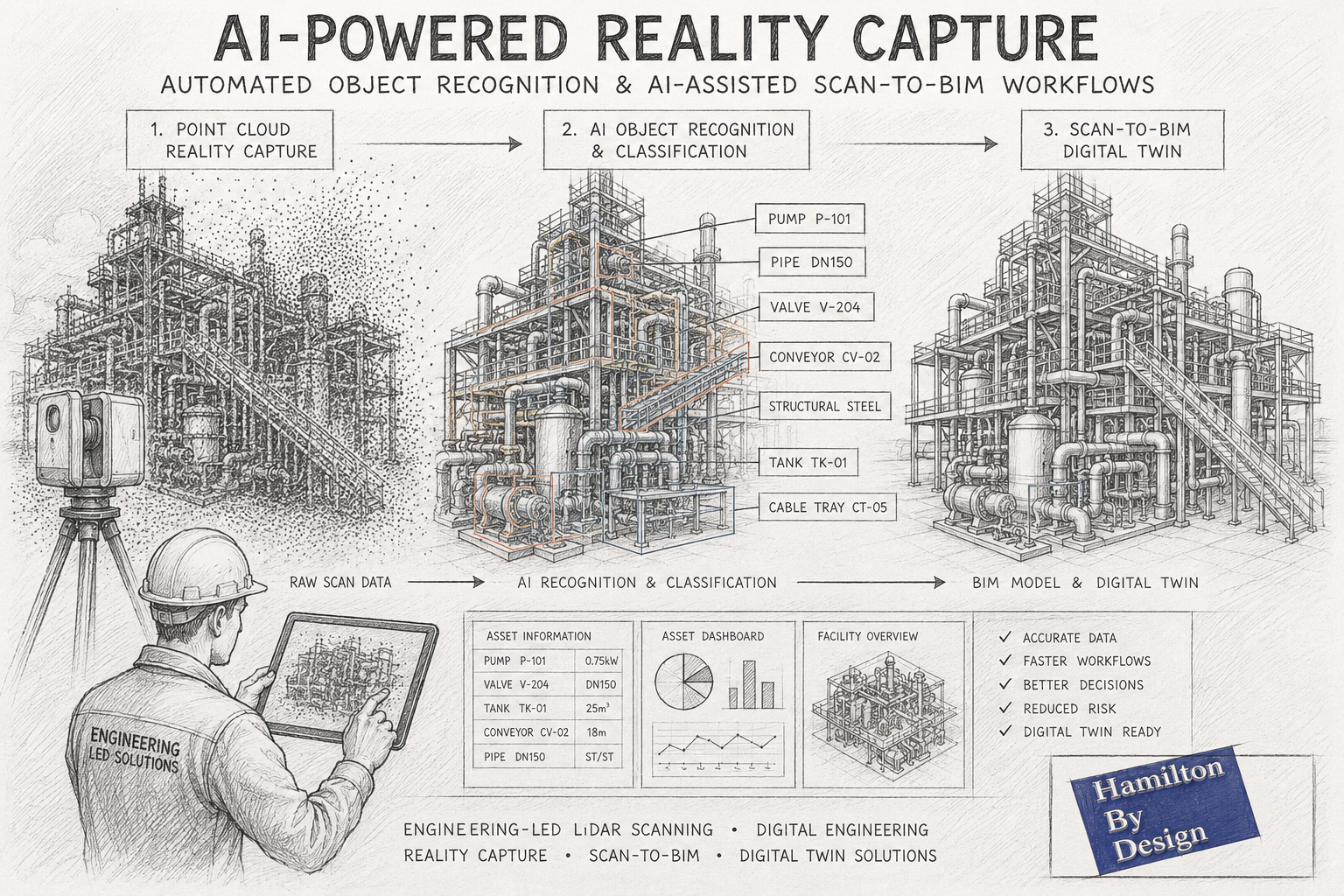
AI-assisted Scan-to-BIM workflow illustrated as a pencil sketch showing an industrial processing plant progressing from LiDAR point cloud capture through automated object recognition to a completed BIM digital twin model.

Automated Object Recognition from Point Clouds and AI-Assisted Scan-to-BIM Workflows

How Artificial Intelligence is Transforming Reality Capture and Digital Engineering

The reality capture industry is experiencing a significant transformation. While terrestrial LiDAR scanning, laser scanning and photogrammetry have been widely adopted across mining, manufacturing, construction and infrastructure sectors for many years, the emergence of Artificial Intelligence (AI) is fundamentally changing how point cloud data is processed and utilised.

Traditionally, converting a point cloud into useful engineering information required substantial manual effort. Engineers, designers and BIM technicians would spend hundreds of hours identifying equipment, tracing pipework, modelling structures and generating asset information from raw scan data.

Today, advances in automated object recognition and AI-assisted Scan-to-BIM workflows are reducing these manual processes and opening new opportunities for asset owners, engineering consultants and project teams.

At Hamilton By Design, we continue to monitor and evaluate emerging AI technologies while combining them with engineering-led reality capture workflows to deliver practical outcomes for industrial and infrastructure projects throughout Australia.


What is Automated Object Recognition?

Automated object recognition refers to the ability of software systems to identify and classify objects within a point cloud automatically.

Instead of manually examining millions or billions of points, AI algorithms analyse geometric patterns, spatial relationships, colours and textures to determine what each object represents.

For example, AI systems may automatically identify:

  • Structural steel members
  • Pipework systems
  • Valves
  • Pumps
  • Conveyors
  • Electrical equipment
  • Cable trays
  • Tanks and vessels
  • Building columns
  • Walls and floors
  • Doors and windows
  • Handrails and platforms
  • Mechanical equipment

The objective is to transform unstructured point cloud data into structured engineering information.

This allows project teams to move from raw scan data to usable digital assets much faster than traditional modelling methods.


Understanding Point Clouds

A point cloud is a collection of millions or billions of measured points captured using:

  • Terrestrial LiDAR scanners
  • Mobile mapping systems
  • Drone LiDAR systems
  • Photogrammetry
  • Structured light scanners
  • Handheld scanning systems

Each point contains spatial coordinates representing a physical location in the real world.

Modern scanners can capture:

  • Plant rooms
  • Industrial facilities
  • Processing plants
  • Mining infrastructure
  • Commercial buildings
  • Manufacturing equipment
  • Transport infrastructure
  • Refineries and smelters

The challenge has never been collecting data.

The challenge is turning that data into engineering information.

This is where AI is beginning to provide significant value.


Why Traditional Point Cloud Processing is Time Consuming

Historically, engineering teams have relied on manual modelling workflows.

A typical process might involve:

  1. Capturing scan data
  2. Registering point clouds
  3. Cleaning noise
  4. Importing into CAD or BIM software
  5. Identifying equipment manually
  6. Modelling structures
  7. Modelling pipework
  8. Generating asset information
  9. Producing drawings and deliverables

For complex facilities such as mines, smelters, power stations and manufacturing plants, this work can require hundreds or even thousands of engineering hours.

Although highly accurate, these workflows can be expensive and time intensive.


How AI is Changing Reality Capture

Artificial Intelligence is introducing a new layer of automation.

Modern AI systems can learn from vast datasets of industrial and architectural objects.

Rather than simply displaying a point cloud, AI attempts to understand what the data represents.

Examples include:

Pipe Recognition

AI algorithms can automatically identify cylindrical features and classify them as pipework.

Software can estimate:

  • Pipe centre lines
  • Pipe diameters
  • Connections
  • Elbows
  • Tees
  • Reducers

Structural Steel Recognition

Machine learning systems can identify:

  • Universal beams
  • Columns
  • Channels
  • Angles
  • Bracing members

This can accelerate structural modelling workflows.

Equipment Classification

AI systems are increasingly capable of identifying:

  • Pumps
  • Motors
  • Gearboxes
  • Tanks
  • Vessels
  • Heat exchangers

Although verification is still required, the process can dramatically reduce manual modelling time.

Building Element Recognition

For architectural and BIM applications, AI can automatically detect:

  • Walls
  • Floors
  • Ceilings
  • Doors
  • Windows
  • Roof systems

This enables faster generation of BIM models.


What is AI-Assisted Scan-to-BIM?

Scan-to-BIM is the process of converting reality capture data into Building Information Models.

Traditionally, BIM technicians manually created geometry based on point cloud information.

AI-assisted Scan-to-BIM introduces automated recognition tools that accelerate this process.

The workflow generally follows:

Step 1 โ€“ Reality Capture

A facility is scanned using terrestrial LiDAR technology.

Hamilton By Design typically captures:

  • Industrial facilities
  • Manufacturing plants
  • Mining infrastructure
  • Commercial buildings
  • Mechanical plant rooms
  • Process facilities

Step 2 โ€“ Point Cloud Registration

Individual scans are combined into a single registered dataset.

The result becomes a complete digital representation of the facility.

Step 3 โ€“ AI Object Recognition

Artificial Intelligence analyses the point cloud.

Potential objects are automatically identified and classified.

Step 4 โ€“ BIM Generation

Recognised objects are converted into BIM components.

This may include:

  • Structural members
  • Architectural features
  • Mechanical equipment
  • Pipework
  • Services

Step 5 โ€“ Engineering Verification

Engineers and BIM specialists verify the results.

This remains one of the most important stages.

AI can accelerate workflows, but engineering judgement remains essential.

Step 6 โ€“ Digital Twin Development

The resulting BIM model can support:

  • Asset management
  • Facility upgrades
  • Maintenance planning
  • Shutdown planning
  • Construction sequencing
  • Digital twin initiatives

Applications in Mining and Heavy Industry

Mining operations generate enormous quantities of asset information.

Facilities often contain:

  • Conveyors
  • Crushers
  • Chutes
  • Screens
  • Tanks
  • Pipework
  • Structural steel
  • Electrical infrastructure

AI-assisted recognition has the potential to significantly improve the efficiency of:

Brownfield Modifications

Existing assets can be scanned and classified more rapidly.

Shutdown Planning

Equipment and access areas can be documented more efficiently.

Asset Registers

Physical assets can be linked to digital asset management systems.

Digital Twin Creation

AI can accelerate the development of operational digital twins.

Condition Assessment

Automated recognition may eventually support condition monitoring and defect identification.


Current Limitations of AI Recognition

Despite impressive progress, AI is not yet capable of fully replacing experienced engineers.

Several challenges remain.

Complex Industrial Environments

Industrial facilities contain:

  • Congested pipework
  • Obstructions
  • Corrosion
  • Dust accumulation
  • Non-standard equipment

These conditions can confuse automated systems.

Unique Equipment

Mining and manufacturing plants often contain custom-built equipment.

AI systems trained on generic datasets may struggle to identify these assets accurately.

Data Quality

Recognition performance depends heavily on:

  • Scan quality
  • Resolution
  • Registration accuracy
  • Coverage

Poor quality input data typically produces poor quality output.

Engineering Intent

AI can identify geometry.

Understanding engineering intent remains much more difficult.

An experienced engineer can determine:

  • Why a system was designed a certain way
  • Potential maintenance issues
  • Access requirements
  • Structural concerns
  • Process constraints

This knowledge is difficult to automate.


Why Engineering Expertise Still Matters

At Hamilton By Design, we believe AI should be viewed as an engineering productivity tool rather than a replacement for engineering expertise.

The highest quality outcomes are achieved when:

  • High-quality scan data is captured
  • AI assists with recognition
  • Engineers validate results
  • Designers refine models
  • Project teams apply practical experience

This hybrid approach combines automation with engineering judgement.

For industrial facilities, this remains the most reliable pathway to accurate digital deliverables.


The Future of AI in Reality Capture

Over the next decade we expect to see:

Faster Model Creation

Many routine modelling tasks will become increasingly automated.

Improved Asset Classification

AI systems will recognise a broader range of industrial equipment.

Automated Drawing Generation

Point clouds may eventually generate engineering drawings automatically.

Predictive Asset Management

Digital twins may combine scan data with operational data to predict failures.

Real-Time Facility Updates

Facilities may continuously update digital models as changes occur.

Intelligent Maintenance Planning

AI systems could identify maintenance requirements before failures occur.


How Hamilton By Design Uses Reality Capture Today

Hamilton By Design provides engineering-led reality capture services throughout Australia.

Our services include:

  • Terrestrial LiDAR scanning
  • Engineering-grade reality capture
  • Point cloud registration
  • Scan-to-CAD
  • Scan-to-BIM
  • Reverse engineering
  • Mechanical design
  • Structural modelling
  • Digital engineering support
  • Asset documentation

We work across:

  • Mining
  • Manufacturing
  • Energy
  • Infrastructure
  • Commercial buildings
  • Water and wastewater facilities

Our focus remains on delivering practical engineering outcomes from accurate measured data.

As AI-assisted workflows continue to mature, we expect these technologies to further enhance project efficiency while maintaining the engineering oversight required for complex industrial environments.


Hamilton By Design logo displayed on a blue tilted rectangle with a grey gradient background

Automated object recognition and AI-assisted Scan-to-BIM workflows represent one of the most exciting developments in the reality capture industry.

The ability to automatically identify equipment, classify assets and accelerate BIM creation has the potential to significantly reduce modelling time while improving access to engineering information.

However, successful implementation still depends on high-quality scan data, robust workflows and experienced engineering oversight.

The future of digital engineering is unlikely to be fully manual or fully automated.

Instead, it will combine advanced reality capture technologies, artificial intelligence and practical engineering expertise to create smarter, more efficient project delivery.

For organisations looking to develop accurate digital representations of existing assets, AI-assisted reality capture is rapidly becoming an important part of the engineering toolkit.


Contact Us – Talk to Us

Name
Would you like us to arrange a phone consultation for you?
Address


Mechanical Engineering | Structural Engineering


3D CAD Modelling Australia service banner for Hamilton By Design
Australian Drafting logo featuring bold white text reading "Australian Drafting" centred on a blue rounded rectangle background.
Engineering Governance title graphic featuring bold white text reading "Engineering Governance" centred on a blue rounded rectangle background.
Mechanical, Structural & Pipework Drafting service banner by Hamilton By Design featuring white text on a blue background.
Mechanical engineering services
Blue rounded button with the text โ€œSolidWorks Designโ€ in white.
Finite Element Analysis (FEA) engineering simulation button
3D LiDAR Scanning Darwin for engineering surveys, laser scanning, reality capture and point cloud modelling services
3D LiDAR Scanning Australia engineering services for laser scanning, reality capture, scan-to-CAD, Scan-to-BIM and as-built documentation across Australia
3D LiDAR scanning services on the Central Coast providing engineering-grade laser scanning, point cloud capture, scan-to-CAD modelling and industrial reality capture for infrastructure and industrial projects.
3D LiDAR Scanning Perth for engineering surveys, laser scanning, reality capture and point cloud modelling services
3D LiDAR Scanning Sydney for engineering surveys, laser scanning, reality capture and point cloud modelling services
3D LiDAR Scanning Brisbane for engineering surveys, laser scanning, reality capture and point cloud modelling services
3D LiDAR Scanning Canberra for engineering surveys, laser scanning, reality capture and point cloud modelling services
3D LiDAR Scanning Newcastle for engineering surveys, laser scanning, reality capture and point cloud modelling services
3D LiDAR Scanning Adelaide for engineering surveys, laser scanning, reality capture and point cloud modelling services
3D LiDAR Scanning Darwin for engineering surveys, laser scanning, reality capture and point cloud modelling services
3D LiDAR Scanning Australia engineering services for laser scanning, reality capture, scan-to-CAD, Scan-to-BIM and as-built documentation across Australia
3D LiDAR scanning services on the Central Coast providing engineering-grade laser scanning, point cloud capture, scan-to-CAD modelling and industrial reality capture for infrastructure and industrial projects.

LiDAR Scanning Brisbane | Engineering Grade 3D Laser Scanning & Scan to CAD

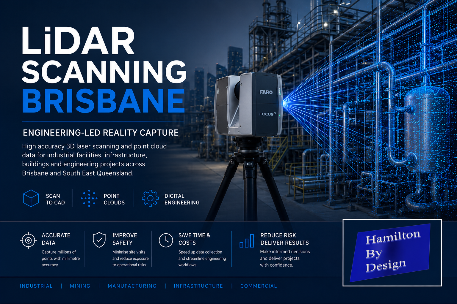
Engineering-led LiDAR scanning in Brisbane showing a terrestrial laser scanner capturing an industrial processing plant with point cloud data for Scan to CAD, reality capture and digital engineering services.

LiDAR Scanning Brisbane โ€“ Engineering-Led 3D Laser Scanning & Digital Engineering Services

LiDAR Scanning Brisbane

Blue 3D LiDAR scanner icon on a tripod with scanning waves

Hamilton By Design provides engineering-led LiDAR scanning services throughout Brisbane and South East Queensland, delivering accurate point cloud data for industrial facilities, mining infrastructure, manufacturing plants, commercial buildings, water treatment facilities and large-scale engineering projects.

Unlike traditional survey-only providers, our team combines practical mechanical engineering, drafting and digital engineering experience with advanced terrestrial laser scanning technology. This allows us to capture existing conditions quickly and accurately while understanding how the data will be used during engineering design, shutdown planning, asset management and construction projects.

Whether you require a simple Scan to CAD deliverable or a complete digital engineering solution, our Brisbane LiDAR scanning services provide a reliable foundation for project success.


What is LiDAR Scanning?

LiDAR (Light Detection and Ranging) is a technology that uses laser pulses to measure millions of points in three-dimensional space. The result is a highly detailed digital representation of an asset, structure or facility known as a point cloud.

LiDAR scanning can accurately capture:

  • Structural steelwork
  • Mechanical equipment
  • Pipework systems
  • Conveyors and materials handling systems
  • Processing plants
  • Buildings and facilities
  • Platforms, stairs and access systems
  • Tanks and pressure vessels
  • Mining and mineral processing infrastructure

The collected data can then be converted into engineering drawings, 3D CAD models, BIM models and asset management information.


Engineering-Led LiDAR Scanning

At Hamilton By Design, LiDAR scanning is supported by real engineering experience.

Our team has experience across:

  • Mechanical engineering
  • Structural drafting
  • Pipework drafting
  • Materials handling systems
  • Smelters and refineries
  • Coal handling and preparation plants (CHPP)
  • Mining infrastructure
  • Manufacturing facilities
  • Water and wastewater treatment plants
  • Industrial shutdown projects

Because we understand how engineering information is used, we focus on capturing the information required for successful project delivery rather than simply collecting point cloud data.


LiDAR Scanning Applications

Industrial Facilities

Capture complete facilities for future engineering, expansion projects and asset management.

Mechanical Engineering

Generate accurate as-built information for equipment upgrades, maintenance planning and reverse engineering projects.

Structural Drafting

Produce existing structural steel models and detailed drafting for modifications and compliance assessments.

Pipework Design

Create accurate pipe routing models and clash detection studies before fabrication and installation.

Construction Verification

Verify installed works against design models and identify deviations before project completion.

Shutdown Planning

Reduce site visits and improve engineering productivity by creating a digital twin of the facility.


Scan to CAD Brisbane

Our Scan to CAD services transform LiDAR point cloud data into usable engineering deliverables including:

  • AutoCAD drawings
  • General arrangement drawings
  • Floor plans
  • Sections and elevations
  • Structural steel models
  • Mechanical equipment models
  • Pipework models
  • Inventor models
  • SolidWorks models
  • STEP and SAT files

This process enables engineering teams to work from accurate existing conditions while reducing project risk.


Benefits of LiDAR Scanning

Improved Safety

Reduce the need for repeated site access and minimise exposure to operational hazards.

Increased Accuracy

Capture millions of measurements with engineering-grade accuracy.

Reduced Project Risk

Identify clashes, access issues and existing site constraints before design begins.

Faster Project Delivery

Engineering teams can work from a complete digital record rather than relying on manual measurements.

Future-Proof Asset Information

Create a permanent digital record for future maintenance, upgrades and expansion projects.


Brisbane Industries We Support

Hamilton By Design supports projects throughout Brisbane and South East Queensland including:

  • Mining and mineral processing
  • Smelting and refining
  • Power generation
  • Water and wastewater treatment
  • Manufacturing
  • Food and beverage processing
  • Ports and logistics
  • Infrastructure projects
  • Commercial buildings
  • Government assets

We regularly support projects throughout:

  • Brisbane CBD
  • Eagle Farm
  • Pinkenba
  • Lytton
  • Port of Brisbane
  • Ipswich
  • Logan
  • Redcliffe
  • Caboolture
  • Toowoomba
  • Gold Coast
  • Sunshine Coast

Deliverables

Typical deliverables include:

  • Registered point clouds (E57, RCP, RCS, LAS)
  • Scan to CAD models
  • AutoCAD drawings
  • Structural drafting packages
  • Mechanical drafting packages
  • Pipework models
  • As-built verification reports
  • BIM models
  • Clash detection studies
  • Engineering support documentation

Why Choose Hamilton By Design?

Hamilton By Design combines practical trade experience, engineering expertise and advanced LiDAR technology to deliver real-world outcomes for industrial projects.

Our team brings experience as:

  • Mechanical Engineers
  • Draftspersons
  • Fitters and Turners
  • Site-based Engineering Personnel
  • Project Leaders
  • Digital Engineering Specialists

This combination allows us to understand both the physical asset and the engineering requirements behind every project.


Hamilton By Design logo displayed on a blue tilted rectangle with a grey gradient background

LiDAR Scanning Brisbane โ€“ Get Started

Whether you require a one-day site scan, a complete facility capture or an engineering-led digital twin solution, Hamilton By Design can provide accurate and reliable LiDAR scanning services throughout Brisbane and Southeast Queensland.

Contact Hamilton By Design today to discuss your LiDAR scanning, Scan to CAD, structural drafting, mechanical drafting and digital engineering requirements.

Contact Us – Talk to Us

Name
Would you like us to arrange a phone consultation for you?
Address

Our Clients

Reality Capture Brisbane title graphic with white text on a blue background promoting reality capture, LiDAR scanning and digital engineering services in Brisbane, Queensland.
3D Scanning Brisbane text graphic on a blue background promoting engineering-led laser scanning and reality capture services in Brisbane.

LiDAR Scanning Brisbane title graphic with white text on a blue background promoting terrestrial LiDAR scanning, point cloud capture and reality capture services in Brisbane, Queensland.
SolidWorks Brisbane title graphic with white text on a blue background promoting SolidWorks mechanical design, 3D CAD modelling and engineering drafting services in Brisbane, Queensland.


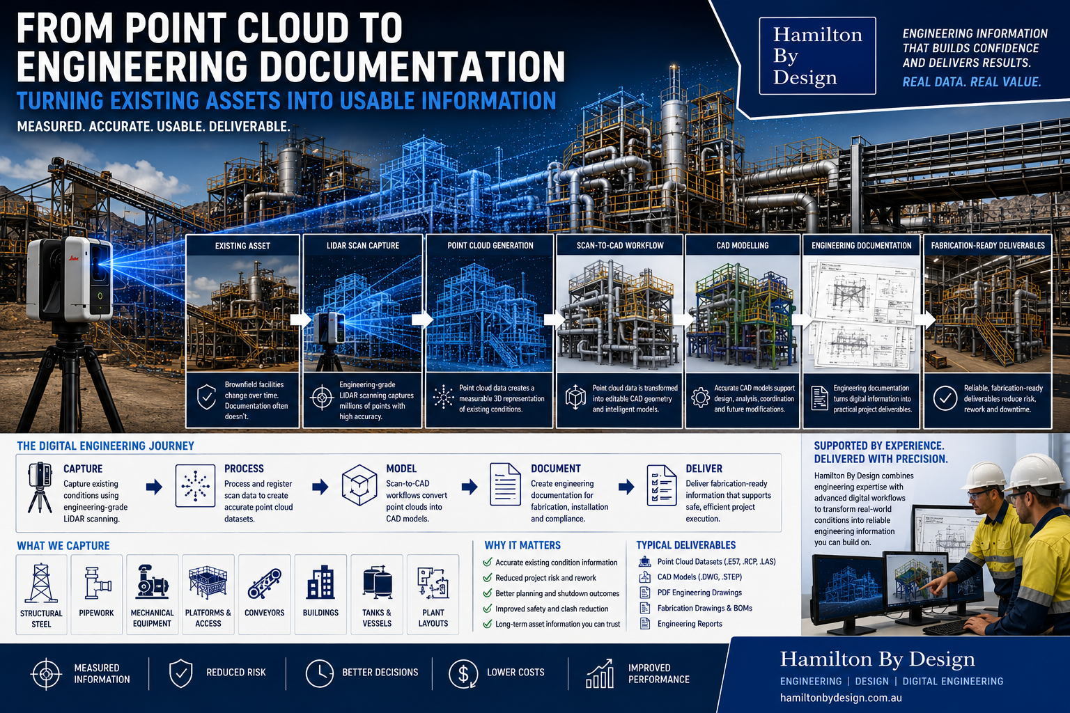
From Point Cloud to Engineering Documentation: Turning Existing Assets into Usable Information

Engineering-grade LiDAR scanning and digital engineering workflow showing point cloud data transformed into CAD models and fabrication-ready engineering documentation.

Industrial facilities are constantly changing. Equipment is upgraded, structures are modified, process lines evolve, and maintenance-driven changes gradually reshape plant layouts over time.

Unfortunately, engineering documentation does not always evolve at the same pace.

Many facilities eventually reach a point where the question becomes:

“What actually exists on site today?”

When drawings become outdated or documentation is missing, engineering teams can face increased project risk, fabrication challenges, and costly rework.

Modern digital engineering workflows now allow physical assets to be transformed into accurate engineering information through engineering-grade LiDAR scanning, point cloud generation, and Scan-to-CAD workflows.

At Hamilton By Design, we support industrial and mining projects by converting real-world conditions into practical engineering deliverables that support design, fabrication, and long-term asset management.

Why Existing Information Matters

Engineering decisions rely on information.

Drawings and documentation support:

  • Plant upgrades
  • Maintenance activities
  • Shutdown planning
  • Equipment replacement
  • Fabrication projects
  • Asset management
  • Future modifications

When information becomes inaccurate, project uncertainty increases.

Potential impacts may include:

  • Installation clashes
  • Fabrication errors
  • Rework
  • Delays
  • Safety risks
  • Increased project cost

Reliable engineering information begins with understanding existing conditions.

Engineering-Grade LiDAR Scanning

The first step involves capturing the physical environment.

Hamilton By Design uses engineering-grade 3D LiDAR scanning to record:

  • Structural steel
  • Pipework
  • Mechanical equipment
  • Platforms and access systems
  • Buildings
  • Conveyors
  • Processing equipment
  • Existing plant layouts

Unlike manual measurements, LiDAR scanning captures millions of measured points from real operating environments.

Benefits can include:

  • Existing condition verification
  • Reduced assumptions
  • Improved accuracy
  • Faster information capture
  • Reduced project risk

Point Cloud Generation

Following site capture, scan information is processed into a point cloud dataset.

Point clouds provide a measurable digital representation of existing assets.

Typical outputs may include:

  • .E57 files
  • .RCP files
  • .LAS files
  • Registration reports

Point cloud datasets provide:

  • Spatial information
  • Existing geometry
  • Equipment relationships
  • Measured dimensions
  • Existing plant layouts

This information forms the foundation for engineering workflows.

Scan-to-CAD Workflows

Point cloud information becomes significantly more valuable when converted into editable engineering data.

Scan-to-CAD workflows allow engineers to transform captured geometry into:

  • Mechanical models
  • Structural models
  • Equipment layouts
  • Existing condition models
  • Plant modifications
  • Engineering assemblies

Rather than working from assumptions, engineers can work from measured information.

CAD Modelling

CAD models transform captured information into usable engineering assets.

Benefits may include:

  • Editable geometry
  • Future design flexibility
  • Improved project coordination
  • Better visualisation
  • Long-term asset information

Typical CAD outputs can include:

  • Solid models
  • Assembly models
  • Layout models
  • Mechanical drawings
  • Structural models

Digital models become valuable engineering assets beyond a single project.

Engineering Documentation

Models alone do not build equipment.

Engineering documentation converts digital information into practical project deliverables.

Documentation may include:

  • General arrangement drawings
  • Detail drawings
  • Fabrication drawings
  • Bills of materials
  • Assembly documentation
  • Engineering reports

Engineering documentation creates information that fabrication and construction teams can use confidently.

Fabrication-Ready Deliverables

The final objective is delivering usable engineering information.

Hamilton By Design deliverables may include:

  • Point cloud datasets
  • CAD models
  • PDF drawings
  • DWG files
  • STEP files
  • Fabrication documentation
  • Engineering reports

The focus is moving beyond visual models toward deliverables that support real-world implementation.

How Hamilton By Design Supports Digital Engineering

Hamilton By Design combines practical engineering knowledge and digital workflows including:

  • Engineering-grade 3D LiDAR scanning
  • Existing condition capture
  • Point cloud generation
  • Scan-to-CAD workflows
  • CAD modelling
  • Engineering documentation
  • Fabrication-ready deliverables

Our objective is creating accurate engineering information that reduces project uncertainty and supports better outcomes.

Turning Existing Assets into Usable Information

Existing assets contain valuable engineering information.

The challenge is transforming that information into something practical and usable.

3D LiDAR scanning and 3D modelling service button โ€” laser scanner capturing a point cloud for engineering and CAD modelling
Mechanical engineering services

Digital engineering workflows allow organisations to move from:

Physical Asset โ†’ Point Cloud โ†’ CAD Model โ†’ Engineering Documentation โ†’ Fabrication

When accurate information supports engineering decisions, project confidence improves.

Measured information creates better engineering outcomes than assumptions.

Hamilton By Design logo displayed on a blue tilted rectangle with a grey gradient background

Our Clients:

Name
Would you like us to arrange a phone consultation for you?
Address
Finite Element Analysis (FEA) engineering simulation button
Mechanical engineering services

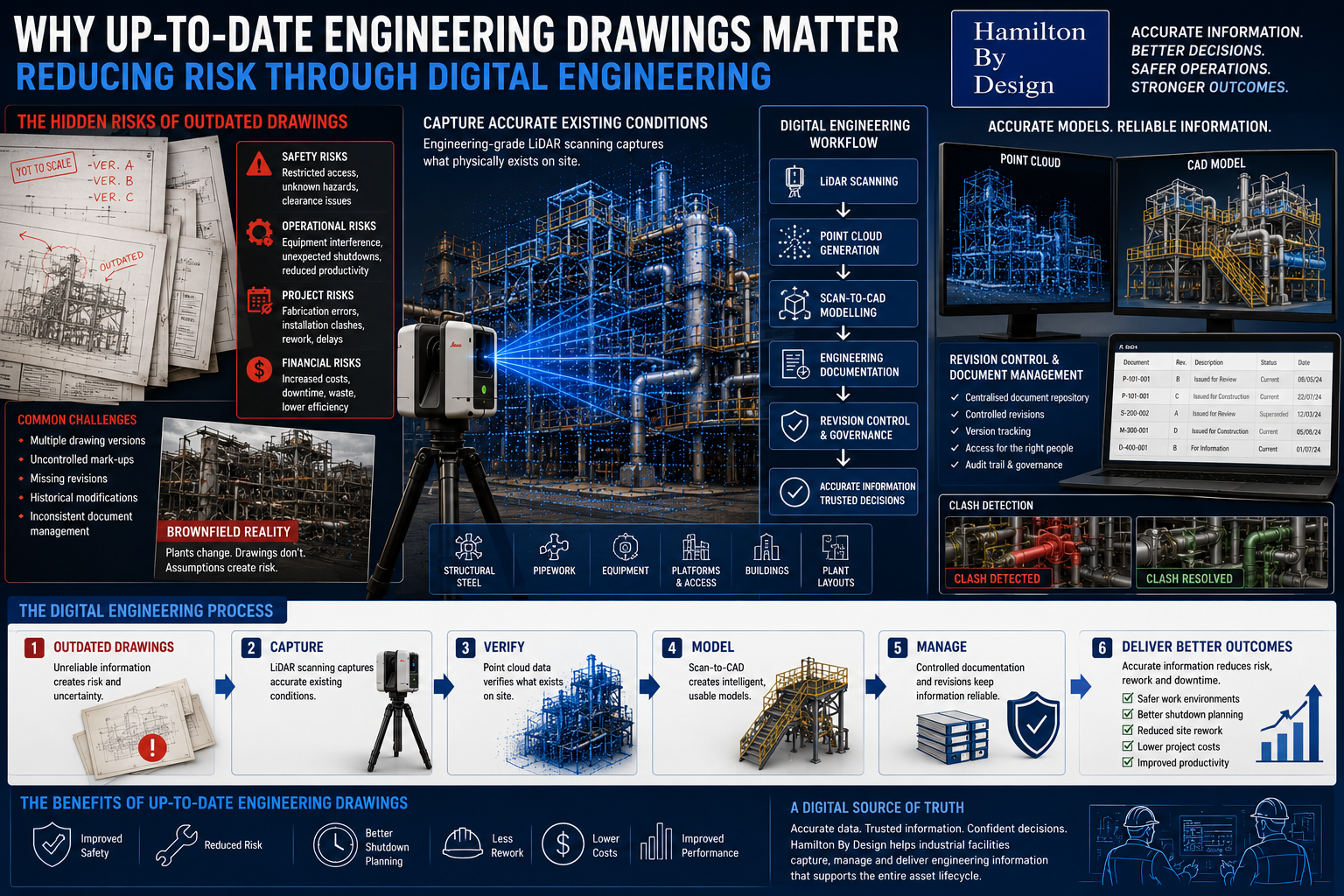
Why Up-to-Date Engineering Drawings Matter: Reducing Risk Through Digital Engineering

Engineering-grade LiDAR scanning and digital engineering workflow showing how updated engineering drawings reduce project risk and improve asset management.

Industrial facilities rarely remain unchanged throughout their operating life. Equipment is upgraded, structural modifications occur, pipework is rerouted, platforms are added, and maintenance-driven changes become part of everyday operations.

Over time, these modifications can create a disconnect between what exists on site and what engineering documentation says exists.

When engineering drawings no longer accurately represent site conditions, the consequences can extend beyond inconvenience. Outdated information can introduce operational risk, safety concerns, project delays, and increased costs.

At Hamilton By Design, we believe engineering decisions should be based on accurate, measured information rather than assumptions.

Digital engineering workflows help transform existing assets into reliable engineering information that supports safer and more efficient project outcomes.

Why Engineering Drawings Matter

Engineering drawings provide more than dimensions and layouts.

They support:

  • Equipment maintenance
  • Plant upgrades
  • Shutdown activities
  • Fabrication works
  • Safety planning
  • Operational decisions
  • Future modifications

Drawings often become the primary source of information used by:

  • Engineers
  • Maintenance personnel
  • Project teams
  • Contractors
  • Fabricators
  • Operations personnel

If the information is incorrect, downstream decisions may also become incorrect.

3D CAD Modelling Australia service banner for Hamilton By Design

Risks Created by Outdated Drawings

Even relatively small discrepancies between site conditions and engineering documentation can create significant problems.

Potential risks include:

Safety Risks

Outdated information may create:

  • Restricted access areas
  • Unidentified hazards
  • Clearance issues
  • Manual handling challenges
  • Unsafe work conditions

Operational Risks

Incorrect information can contribute to:

  • Equipment interference
  • Unexpected shutdown activities
  • Reduced productivity
  • Increased maintenance complexity

Project Risks

Engineering teams may encounter:

  • Fabrication errors
  • Installation clashes
  • Rework requirements
  • Increased labour costs
  • Schedule delays

Financial Risks

Minor inaccuracies can result in:

  • Increased project costs
  • Extended downtime
  • Material waste
  • Reduced project efficiency

Drawing Revisions and Version Control

Many industrial facilities operate using drawings developed over long periods of time.

Common challenges include:

  • Multiple drawing versions
  • Uncontrolled mark-ups
  • Missing revisions
  • Historical modifications
  • Inconsistent document management

Without effective version control, personnel may unknowingly use outdated information.

Digital engineering workflows support:

  • Revision tracking
  • Controlled updates
  • Centralised documentation
  • Improved information accessibility
  • Better engineering governance

Maintaining a controlled environment for engineering information helps reduce risk.

Existing Condition Capture

One of the most effective methods of maintaining drawing accuracy is capturing what physically exists on site.

Hamilton By Design supports projects through engineering-grade 3D LiDAR scanning to capture:

  • Structural steel
  • Pipework
  • Platforms
  • Mechanical equipment
  • Buildings
  • Existing plant layouts
  • Access systems

Existing condition capture allows engineering teams to work with measured information rather than assumptions.

Brownfield Projects Create Additional Challenges

Brownfield environments commonly include:

  • Historical modifications
  • Legacy equipment
  • Congested layouts
  • Existing structures
  • Limited access areas
  • Undocumented changes

Original documentation often no longer reflects actual site conditions.

Using inaccurate information during brownfield projects can increase:

  • Design uncertainty
  • Installation difficulties
  • Rework
  • Shutdown impacts
  • Fabrication risk

Engineering Governance and Digital Engineering

Digital engineering supports a structured approach to managing engineering information.

Engineering governance may include:

  • Revision control systems
  • Centralised documentation
  • Scan-to-CAD workflows
  • Digital asset information
  • Controlled engineering updates
  • Long-term information management

The objective is creating a digital source of truth where project teams can access reliable information.

Supporting Shutdown Planning

Shutdown periods are often constrained by:

  • Time limitations
  • Labour availability
  • Production requirements
  • Safety considerations

Incorrect engineering information during shutdowns can create:

  • Unexpected site modifications
  • Delays
  • Increased labour requirements
  • Reduced productivity

Accurate digital engineering information supports:

  • Improved planning
  • Better coordination
  • Reduced uncertainty
  • Reduced downtime

Reducing Site Rework

Site rework often results from discovering problems after fabrication or installation begins.

Typical causes include:

  • Missing dimensions
  • Existing condition inaccuracies
  • Equipment clashes
  • Incorrect assumptions
  • Documentation errors

Digital workflows including:

  • Existing condition capture
  • Point cloud modelling
  • Scan-to-CAD processes
  • Clash detection

can help identify issues before they become site problems.

How Hamilton By Design Supports Digital Engineering

Hamilton By Design combines engineering experience with digital workflows including:

  • Engineering-grade 3D LiDAR scanning
  • Existing condition capture
  • Scan-to-CAD workflows
  • CAD modelling
  • Engineering documentation
  • Engineering governance
  • Fabrication-ready deliverables

The goal is not simply creating drawings.

The goal is creating reliable engineering information that supports better operational decisions.

3D LiDAR scanning and 3D modelling service button โ€” laser scanner capturing a point cloud for engineering and CAD modelling
Mechanical engineering services

Better Information Creates Better Outcomes

Drawings influence every stage of an asset lifecycle.

When information becomes outdated, risk increases.

Maintaining accurate engineering documentation supports:

  • Safety improvements
  • Reduced project risk
  • Better shutdown outcomes
  • Reduced rework
  • Improved operational performance

Up-to-date engineering drawings create confidence across engineering, maintenance, and project delivery activities.

Hamilton By Design logo displayed on a blue tilted rectangle with a grey gradient background

Our Clients:

Name
Would you like us to arrange a phone consultation for you?
Address
Finite Element Analysis (FEA) engineering simulation button
Mechanical engineering services

Scan to Design: The Digital Engineering Workflow โ€“ Sydney

Engineer performing 3D laser scanning of industrial structure in Sydney for scan to design workflow and point cloud to CAD modelling

Hamilton By Design provides engineer-led 3D scanning, reality capture, structural drafting and scan-to-design services across Sydney, Parramatta, Penrith, Liverpool and the Blue Mountains.

We support industrial, commercial and infrastructure projects where accurate site information is required before design, fabrication, modification or installation work begins.

Unlike basic LiDAR providers or visual scanning services, our workflow is focused on engineering outcomes. We do not simply capture a point cloud and hand it over. We scan with the end design, drafting and construction process in mind.

From Site Scan to Engineering Design

A successful project starts with accurate site data. Our mobile 3D scanning services allow existing structures, plant rooms, pipework, equipment, access platforms, buildings and industrial assets to be captured in detail.

The scan data can then be used to develop:

  • As-built drawings
  • Structural drafting
  • Mechanical layouts
  • Point cloud to CAD models
  • Design verification models
  • Fabrication-ready geometry
  • Site coordination drawings
  • Modification and upgrade layouts

This process reduces the risk of relying on outdated drawings, manual measurements or assumptions made from site photos.

Reality Capture Sydney

Reality capture provides a digital record of the existing site condition. For brownfield sites, commercial buildings, industrial plants and infrastructure assets, this is often the most reliable starting point for design.

Hamilton By Design provides reality capture services across Sydney, including Parramatta, Penrith, Liverpool and the Blue Mountains. Our scanning process is suited to projects where geometry, clearances, access, structural interfaces and installation constraints matter.

3D Scanning Services Parramatta

For projects in Parramatta and Western Sydney, 3D scanning can assist with building upgrades, plant modifications, structural steel layouts, services coordination and as-built documentation.

Our team can capture the existing site and develop usable CAD information for engineers, builders, fabricators and project managers.

3D Laser Scanning Penrith and Blue Mountains

Hamilton By Design also provides 3D laser scanning services in Penrith and the Blue Mountains.

These areas often include a mix of industrial, commercial, civil and difficult-access sites. A 3D scanner can capture complex geometry quickly and accurately, helping project teams understand the real site condition before design or construction begins.

3D CAD Modelling Australia service banner for Hamilton By Design

3D Scanning Liverpool

For Liverpool and South-West Sydney, our 3D scanning services support commercial buildings, industrial facilities, warehouses, workshops and infrastructure-related projects.

Scanning is particularly useful when existing drawings are missing, unreliable or not detailed enough for modification work.

Structural Drafting Sydney

Hamilton By Design provides structural drafting services in Sydney using accurate site data from 3D scanning where required.

This is valuable for:

  • Structural steel modifications
  • Access platforms
  • Mezzanine structures
  • Plant support steelwork
  • Equipment bases
  • Walkways and maintenance access
  • Existing building documentation
  • Fabrication coordination

By combining structural drafting with scan data, we help reduce clashes, rework and uncertainty during fabrication and installation.

As-Built Drawing Services vs LiDAR Providers

There is an important difference between basic LiDAR scanning and engineering-grade as-built documentation.

A LiDAR provider may capture a point cloud. However, an engineering-led workflow considers what the point cloud needs to become.

Hamilton By Design focuses on the full digital engineering workflow:

Scan โ†’ Register โ†’ Review โ†’ Model โ†’ Draft โ†’ Design โ†’ Deliver

This means the scan is captured with an understanding of engineering intent, line of sight, constructability, component fit-up and drafting requirements.

Point Cloud Scanning Services

Our point cloud scanning services can provide a reliable digital record of existing conditions. Depending on the project scope, deliverables may include:

  • Registered point cloud data
  • Point cloud viewing files
  • CAD-ready reference data
  • As-built drawings
  • 3D models
  • Structural or mechanical design layouts
  • Sections, elevations and general arrangement drawings

Point cloud data is especially useful where projects involve existing structures, old drawings, tight clearances or complex site interfaces.

Mobile 3D Scanning Services

Hamilton By Design provides mobile 3D scanning services across Sydney and surrounding regions. We can attend site, scan the required area and develop practical engineering deliverables from the captured data.

This service is suited to:

  • Industrial sites
  • Commercial buildings
  • Warehouses
  • Plant rooms
  • Workshops
  • Mining and bulk handling equipment
  • Building upgrades
  • Structural steel projects
  • Mechanical equipment installations

Why Choose Hamilton By Design

Hamilton By Design is an engineer-led organisation. We provide more than visual scanning. Our focus is on accurate site capture, practical modelling and design-ready documentation.

We understand that project teams need information they can use for design, fabrication, installation and decision-making.

Our scan-to-design workflow helps clients move from uncertain site conditions to clear engineering deliverables.

3D LiDAR scanning and 3D modelling service button โ€” laser scanner capturing a point cloud for engineering and CAD modelling
Mechanical engineering services

Our Clients

Service Areas

Hamilton By Design provides 3D scanning, structural drafting and reality capture services across:

Sydney, Parramatta, Penrith, Liverpool, Blue Mountains, Western Sydney, Central Coast, Newcastle and surrounding regions.

Hamilton By Design logo displayed on a blue tilted rectangle with a grey gradient background

Talk to Hamilton By Design

If your project requires 3D scanning, point cloud scanning services, as-built drawing services, structural drafting or scan-to-design support, Hamilton By Design can assist from site capture through to engineering documentation.

We help turn real-world site conditions into practical digital engineering information.

3D Scanning Sydney banner promoting engineering-grade 3D laser scanning, LiDAR scanning, and reality capture services by Hamilton By Design.
Mechanical Engineering Sydney banner with white text on a blue background representing Hamilton By Design's mechanical engineering services in Sydney.
Mechanical Drafting and 3D Modelling Sydney banner highlighting Hamilton By Design's CAD drafting, 3D modelling, and engineering design services in Sydney.

Mechanical Engineering | Structural Engineering


Contact Us – Talk to Us – Work with Us

Name
Would you like us to arrange a phone consultation for you?
Address

Hamilton By Design provides engineering-led 3D scanning, LiDAR scanning, mechanical engineering and digital engineering services throughout Sydney and Greater Sydney.

Explore our related Sydney services:


  • 3D Scanning Sydney โ€“ Engineering-grade terrestrial laser scanning, as-built surveys and point cloud capture for industrial, infrastructure and commercial projects.
  • Reality Capture Sydney โ€“ High-accuracy reality capture, digital twins, asset documentation and engineering-grade site verification.
  • Scan to CAD Sydney โ€“ Convert point cloud data into AutoCAD, SolidWorks, Inventor and other engineering-ready CAD deliverables.
  • Point Cloud Modelling Sydney โ€“ Engineering-grade point cloud processing, clash detection, as-built verification and 3D modelling.
  • Mechanical Engineering Sydney โ€“ Mechanical design, plant upgrades, materials handling systems, conveyors, chutes, platforms and engineering support.


  • Structural Drafting Sydney โ€“ Structural steel drafting, fabrication drawings, GA drawings, workshop detailing and as-built documentation.

Hamilton By Design supports projects throughout Sydney CBD, Parramatta, Liverpool, Penrith, Blacktown, Chatswood, Alexandria, Mascot, Newcastle and the Central Coast.


Blue banner graphic displaying the text "Point Cloud to CAD - Australia" in large white lettering, representing point cloud processing, scan-to-CAD conversion and digital engineering services across Australia.

Blue banner graphic displaying the text "Scan to CAD Sydney" in large white lettering, representing engineering-led point cloud to CAD conversion, LiDAR scanning and digital engineering services in Sydney.

Blue banner graphic displaying the text "Reality Capture Sydney - CBD" in large white lettering, representing engineering-led reality capture, LiDAR scanning and digital engineering services within Sydney CBD commercial buildings and infrastructure.

3D LiDAR Scanning Darwin for engineering surveys, laser scanning, reality capture and point cloud modelling services

3D LiDAR Scanning Australia engineering services for laser scanning, reality capture, scan-to-CAD, Scan-to-BIM and as-built documentation across Australia

3D LiDAR scanning services on the Central Coast providing engineering-grade laser scanning, point cloud capture, scan-to-CAD modelling and industrial reality capture for infrastructure and industrial projects.