Mechanical Engineering | 3D Scanning | 3D Modelling
Tag: Terrestrial
Terrestrial scanning and reality capture services using engineering-grade ground-based LiDAR systems to collect accurate point cloud data for industrial facilities, plant upgrades, as-built documentation, and engineering projects.
3D LiDAR Scanning Wyong | Engineering-Grade & Standards-Compliant
Hamilton By Design provides engineering-grade 3D LiDAR scanning in Wyong, delivering accurate as-built data that supports Australian Standards–compliant design, documentation, and construction.
In power, manufacturing, and building & construction environments, the quality of scan data directly affects whether designs are buildable, compliant, and installable. Our approach focuses on engineering accuracy, control, and verification, not just visual capture.
Why engineering-grade LiDAR scanning matters
Not all 3D scanning is equal.
Low-grade or survey-only scans may look impressive but often lack:
Reliable control and datums
Verified accuracy suitable for engineering tolerances
Context around structural, mechanical, and access systems
Confidence that derived drawings will meet Australian Standards
Engineering-grade LiDAR scanning ensures the captured data is suitable for:
Mechanical and structural design
Fabrication and installation
Compliance assessment and upgrade works
This is especially important in Wyong, where many assets are live, brownfield, or undergoing staged upgrades.
Supporting Australian Standards through accurate as-built data
3D LiDAR scanning is not a standard on its own — it is an enabling technology that supports compliance with Australian Standards by providing accurate geometry for engineering decisions.
Our scanning services directly support design and documentation aligned with:
AS 1100 – Technical Drawing Ensuring scan-derived drawings use correct datums, dimensions, and tolerances.
AS 1657 – Access Systems Verifying existing platforms, handrails, head heights, and clearances for upgrades and compliance.
AS 3990 – Mechanical Equipment Steelwork Capturing existing steelwork geometry to support loads, interfaces, and fabrication fit-up.
AS 4100 – Steel Structures Supporting structural verification, strengthening, and modification works.
AS 3774 – Bulk Solids Containers Providing accurate hopper, bin, and chute geometry for load calculations and design checks.
NCC – National Construction Code Supporting building upgrades, refurbishments, and as-built documentation.
Engineering-grade scanning ensures that models and drawings derived from the scan can be relied upon during compliance reviews and construction.
Power, manufacturing & construction scanning in Wyong
Wyong and the northern Central Coast support a mix of energy infrastructure, manufacturing facilities, and construction activity, where accurate as-built data reduces risk.
We support scanning for:
Power stations, substations, and electrical infrastructure
Manufacturing plants, workshops, and industrial facilities
Structural steel, platforms, walkways, and access systems
Plant rooms, services corridors, and retrofit works
Brownfield construction and staged upgrades
LiDAR scanning allows engineering and construction teams to design off-site with confidence, reducing shutdown risk and site rework.
Our Clients:
What makes our scanning engineering-grade
Our approach goes beyond data capture:
Scan planning based on engineering intent
Controlled datums and registration suitable for CAD and fabrication
Accuracy aligned with mechanical and structural tolerances
Interpretation by engineers who understand compliance requirements
Deliverables designed to integrate into engineering workflows
This ensures scan data is fit for purpose, not just visually accurate.
3D CAD models suitable for engineering and fabrication
Interface and clash reviews
Fabrication-ready dimensions and datum strategies
Digital QA documentation supporting compliance and installation
Wyong & Central Coast coverage
We service Wyong and surrounding areas including Tuggerah, Warnervale, Ourimbah, Somersby, Lake Haven, Gosford, Erina, and across the Central Coast.
We also support projects extending into Newcastle, the Hunter Valley, and Greater Sydney, providing consistent engineering-grade scanning across multiple sites.
Get started
If you require 3D LiDAR scanning in Wyong that supports Australian Standards–compliant engineering and construction, Hamilton By Design can help.
Request a quote or book a site scan to discuss an engineering-grade scanning solution tailored to your project.
3D Scanning Services Darwin | Industrial LiDAR for Mining, Ports & Gas
Hamilton By Design delivers engineering-grade 3D scanning services in Darwin and the broader Northern Territory for mining operations, heavy construction projects, port facilities, and oil & gas infrastructure. Our services are engineered to support complex, high-risk environments where accuracy, reliability, and downstream usability of captured data directly influence project outcomes.
Darwin and the Northern Territory’s economy are underpinned by strategic investment in resources, energy, construction, and export infrastructure, including mineral extraction, liquefied natural gas projects, major port facilities, and associated heavy industry developments. nteconomy.nt.gov.au+1 Our 3D scanning services are tailored to meet the demands of these sectors, providing certified capture workflows that support planning, design, modification, fabrication, and compliance deliverables.
Why Darwin Projects Need an Engineering-Grade 3D Scanning Approach
Darwin projects commonly involve live industrial environments, large-scale equipment, and brownfield upgrades where assumptions cost time and money. Our engineering-led 3D scanning services provide precise digital representations of complex assets, enabling safer and faster decision-making on heavy industry projects.
Mining and resources infrastructure The Northern Territory’s mining and resources sector contributes significantly to regional economic output, with mineral extraction, petroleum and natural gas operations, and associated processing facilities forming core project drivers. nteconomy.nt.gov.au+1 High-accuracy capture of pits, processing plants, stockpiles, conveyors, and infrastructure improves planning, risk reduction, and asset management.
Heavy construction and site coordination Darwin is a hub for major construction and industrial projects, where detailed spatial knowledge is essential for avoiding clashes, verifying clearances, and supporting installation sequencing. nteconomy.nt.gov.au
Port and export infrastructure Facilities such as Darwin Port require detailed asset capture for maintenance planning, structural verification, and integration of new systems within operational environments.
Oil, gas and energy facilities Onshore and near-shore gas processing facilities, pipelines, and connected energy infrastructure demand detailed capture for retrofit, upgrade, and compliance work. The region’s ongoing energy projects, including export-oriented gas facilities, benefit from high-resolution site data for engineering assessment. Wikipedia
Our 3D Scanning Services in Darwin
We provide a comprehensive suite of industrial 3D scanning services built around engineering workflows and practical project outcomes:
Engineering-Grade LiDAR Scanning for Heavy Industry Accurate capture of plant, equipment, civil structures, stockpiles, and infrastructure.
Brownfield Retrofit & Upgrade Scanning Reliable, measurable site data to support modification, expansion, and construction.
Construction Coordination & Clash Avoidance High-precision datasets for clash detection, sequencing, and design validation.
Scan-to-CAD Modelling Converting point clouds into usable 3D CAD models for mechanical, structural, and fabrication workflows.
Verified Geometry for Compliance & Design Deliverables suitable for engineering verification, documentation, and approvals.
Precision Scanning for Fabrication & Installation Planning Supporting fit-first-time outcomes and reducing onsite rework.
Each capture is conducted with an understanding of how the data will be used by engineers, designers, and project teams — not as standalone visuals but as actionable digital deliverables.
Our clients:
Industrial Use Cases Common in Darwin
Our Darwin 3D scanning projects frequently support:
Mining processing plants and material handling infrastructure
LNG and gas processing facilities
Heavy civil works and structural upgrades
Port infrastructure modifications and maintenance planning
Mechanical plant retrofit and replacement interfaces
Construction set-out and spatial verification
This focus ensures that scan data supports real engineering workflows — from design and clash detection through to fabrication and installation.
Supporting Engineering Services for Darwin Projects
3D scanning in heavy industry rarely stands alone. Most projects require integrated engineering and documentation workflows, including:
3D CAD Modelling (Scan-to-CAD) Translating site capture into engineering models ready for analysis and design.
As-Built Drawings for Compliance and Procedural Use Detailed documentation suitable for regulatory, contractor, and stakeholder use.
Emergency Exit & Egress Drawing Development Based on reliable scan data to support safety planning and compliance documentation.
Finite Element Analysis (FEA) Engineering verification where structure or component behaviour must be assessed under load.
3D Rendering & Virtual Models Communicating complex spatial data to stakeholders during planning, approvals, or reviews.
Precision Scanning for Fabrication, Renovation & Upgrades Reducing risk and onsite uncertainty for installation and manufacturing.
Our clients
Engineering-Led 3D Scanning You Can Rely On
Hamilton By Design’s 3D scanning services in Darwin are rooted in engineering fundamentals, not just capture. We prioritise data accuracy, usability, and integration with existing workflows, ensuring that point cloud data becomes a reliable foundation for design, construction, compliance, and verification in demanding industrial environments.
Get in Touch About a Darwin 3D Scanning Project
Whether you are planning a mining plant retrofit, infrastructure upgrade, or heavy construction project in Darwin or the Northern Territory, contact Hamilton By Design to discuss your requirements and ensure your project benefits from high-precision, engineering-grade 3D scanning.
3D Scanning Services Sydney | Engineering-Grade LiDAR & As-Built Documentation
Hamilton By Design provides engineering-grade 3D scanning services across Sydney, supporting complex, high-value assets where accuracy, accountability, and downstream usability matter. Our services are led by experienced mechanical engineers and are designed to support real project outcomes — from verified as-built documentation through to fabrication-ready design and analysis.
Sydney projects are rarely greenfield. Most involve upgrades, retrofits, or investigations within live, constrained, and regulation-heavy environments, where incorrect assumptions lead directly to rework, delays, and risk. Our 3D scanning services are structured to reduce that risk by delivering reliable digital site data that can be confidently used for engineering, documentation, and construction decision-making.
Why Sydney Projects Require a Different 3D Scanning Approach
Sydney presents a unique combination of challenges that demand more than basic capture or visual scanning.
Dense brownfield assets Many Sydney projects involve ageing buildings, plant, and infrastructure being modified in place. Accurate geometry is critical where original drawings are incomplete, outdated, or unreliable.
Vertical and constrained environments Multi-storey services, stacked plant rooms, basements, risers, rooftops, and tight access conditions require careful scan planning, controlled registration, and engineering oversight to ensure usable results.
Live and occupied facilities Scanning often occurs within operational buildings such as commercial towers, transport assets, healthcare facilities, ports, and industrial sites. Our workflows prioritise safety, minimal disruption, and capture efficiency.
Regulatory and legal sensitivity Sydney projects commonly require documentation suitable for approvals, audits, handover, or dispute resolution. Scan data and drawings must be traceable, measurable, and defensible — not just visually impressive.
High cost of rework With limited access windows and high construction costs, Sydney projects benefit most from a “scan once, design right” approach that supports fit-first-time outcomes.
Our 3D Scanning Services in Sydney
We deliver a full range of engineering-focused 3D scanning services, tailored to Sydney’s built and industrial environments:
Engineering-grade LiDAR scanning for buildings, plant, and infrastructure
Brownfield and retrofit scanning for upgrades and modifications
Construction and shutdown scanning
Scan-to-CAD workflows for mechanical and structural design
Precision capture for fabrication, renovation, and plant upgrades
Verified geometry for compliance-driven documentation
All scanning is performed with a clear understanding of how the data will be used downstream, ensuring it is suitable for engineering review, modelling, and decision-making.
3D Scanning for Insurance, Legal & Risk Documentation
In Sydney’s high-value and high-density environment, 3D scanning is increasingly used to support insurance, legal, and risk-related documentation following incidents such as fire damage, water ingress, impact events, equipment failure, or partial structural damage.
Engineering-grade 3D scanning provides a permanent digital record of site conditions at a specific point in time, capturing geometry, deformation, and spatial relationships before cleanup or reinstatement works commence. This data supports objective review by engineers, consultants, and stakeholders by enabling measurable verification rather than reliance on photographs alone.
Our engineer-led approach ensures scan data is suitable for formal documentation, technical assessment, and downstream modelling. Dedicated insurance-specific services can be linked or expanded as required at a later stage.
Typical Sydney Project Applications
Our 3D scanning services in Sydney are commonly used for:
Commercial and industrial building upgrades
Mechanical and services retrofits
Asset condition assessment and verification
Construction coordination and clash avoidance
Compliance-driven documentation and handover
Fabrication and installation planning
Supporting Engineering Services for Sydney 3D Scanning Projects
In Sydney, 3D scanning is rarely a standalone deliverable. Most projects require integrated engineering and documentation to achieve compliant, buildable outcomes. Hamilton By Design regularly delivers the following services alongside 3D scanning:
3D CAD Modelling (Scan-to-CAD) Translating verified site data into usable mechanical and structural models.
As-Built Drawings for Legal, Government & Procedural Use Suitable for approvals, audits, asset handover, and formal documentation.
Emergency Exit & Egress Drawing Development Based on verified geometry to support safety reviews and compliance processes.
Finite Element Analysis (FEA) Where scanned data feeds directly into load checks and modification verification.
3D Rendering & Virtual Models Supporting stakeholder review, approvals, and non-technical communication.
Precision Scanning for Fabrication, Renovation & Plant Upgrades Reducing site rework and supporting fit-first-time installation.
Related Sydney Services
Hamilton By Design provides engineering-led 3D scanning, LiDAR scanning, mechanical engineering and digital engineering services throughout Sydney and Greater Sydney.
Explore our related Sydney services:
3D Scanning Sydney – Engineering-grade terrestrial laser scanning, as-built surveys and point cloud capture for industrial, infrastructure and commercial projects.
Reality Capture Sydney – High-accuracy reality capture, digital twins, asset documentation and engineering-grade site verification.
Scan to CAD Sydney – Convert point cloud data into AutoCAD, SolidWorks, Inventor and other engineering-ready CAD deliverables.
Point Cloud Modelling Sydney– Engineering-grade point cloud processing, clash detection, as-built verification and 3D modelling.
Mechanical Engineering Sydney – Mechanical design, plant upgrades, materials handling systems, conveyors, chutes, platforms and engineering support.
Structural Drafting Sydney– Structural steel drafting, fabrication drawings, GA drawings, workshop detailing and as-built documentation.
Hamilton By Design supports projects throughout Sydney CBD, Parramatta, Liverpool, Penrith, Blacktown, Chatswood, Alexandria, Mascot, Newcastle and the Central Coast.
Engineering-Led 3D Scanning You Can Rely On
What sets Hamilton By Design apart is that 3D scanning is delivered as part of an engineering workflow, not as an isolated capture service. We understand how scan data is used, where errors typically occur, and what level of accuracy is required to support real-world outcomes in Sydney’s demanding project environment.
Talk to Us About a Sydney 3D Scanning Project
If you are planning an upgrade, investigation, or documentation project in Sydney and need reliable, engineering-grade 3D scanning, contact Hamilton By Design to discuss your requirements and scope the right capture approach.
3D Point Cloud Modelling Melbourne | Engineering-Led LiDAR Models
Melbourne is home to some of Australia’s most complex industrial, infrastructure, and construction assets. From live manufacturing facilities and transport infrastructure to commercial and brownfield redevelopment projects, accurate understanding of existing conditions is critical.
Hamilton By Design provides engineering-grade 3D point cloud modelling services in Melbourne, supporting projects where precision, constructability, and accountability matter. Our workflows convert high-accuracy LiDAR scan data into usable engineering models that reflect what actually exists on site.
Engineering-Grade Point Cloud Modelling for Melbourne Projects
3D point cloud modelling is not simply about visualisation. For engineering, construction, and industrial projects in Melbourne, point clouds are used to:
Establish accurate existing conditions
Verify interfaces with existing assets
Reduce site rework and clashes
Support constructable design decisions
Enable confident fabrication and installation
Our modelling workflows are developed for engineering and delivery, not presentation.
From 3D Laser Scanning to Usable Engineering Models
All point cloud modelling begins with accurate data capture. Our Melbourne projects are supported by engineering-led 3D laser scanning, producing high-resolution point cloud datasets suitable for detailed modelling and analysis.
Once captured, point cloud data is processed, registered, and validated before being used as the foundation for downstream modelling.
Point Clouds as the Basis for As-Built Modelling
A common challenge on Melbourne projects is the lack of reliable as-built information. Drawings may be outdated, incomplete, or no longer reflect site conditions due to years of undocumented modifications.
Our point cloud modelling services directly address this issue by enabling:
Accurate as-built geometry derived from LiDAR data
Verification of steelwork, plant, and structural interfaces
Confident modelling of upgrades, retrofits, and extensions
For projects requiring documented existing conditions, point clouds are often converted into as-built drawings and models to support engineering, construction, and compliance requirements.
Applications of 3D Point Cloud Modelling in Melbourne
Our Melbourne point cloud modelling services are commonly used across:
Industrial and manufacturing facilities
Mechanical plant upgrades and retrofits
Infrastructure and utilities projects
Construction coordination and verification
Structural steel and access modifications
In these environments, point clouds provide a single, reliable source of truth that engineering teams can trust.
Integration with Engineering and Design Services
Point cloud modelling does not exist in isolation. At Hamilton By Design, point clouds are integrated into broader engineering workflows, supporting:
Mechanical and structural design
CAD modelling and documentation
Constructability review
Interface coordination
Asset information and lifecycle planning
Our point cloud services form part of a wider suite of engineering services delivered nationally, ensuring continuity from site capture through to design and documentation.
For Melbourne projects, the quality of a point cloud model directly affects downstream decisions. Our approach ensures that:
Data is captured with engineering intent
Modelling reflects real-world geometry and tolerances
Assumptions are minimised
Risks are identified early
Models can be relied upon for fabrication and site work
This engineering-owned approach reduces uncertainty and improves project outcomes, particularly on complex or live sites.
3D Point Cloud Modelling Services Across Melbourne
We support projects across metropolitan Melbourne and surrounding regions, including inner-city sites, industrial precincts, and large-scale infrastructure corridors. Whether supporting early project definition or detailed upgrade works, our point cloud modelling services are tailored to the realities of Melbourne’s built environment.
Discuss a 3D Point Cloud Modelling Project in Melbourne
If you require accurate, engineering-grade 3D point cloud modelling in Melbourne, Hamilton By Design can support your project from initial capture through to usable engineering models and documentation.
Contact our team to discuss how point cloud modelling can reduce risk and improve certainty on your next Melbourne project.
Preserving Today’s Information for Tomorrow’s Engineering Decisions
Buildings are long-life assets, but the information describing how they were actually built is often short-lived. Drawings become outdated, undocumented changes accumulate, and critical details disappear once concrete is poured or walls are closed.
Hamilton By Design provides engineering-grade 3D scanning and as-built BIM documentation across Greater Sydney, capturing what actually exists on site and converting it into reliable, decision-ready information that supports maintenance, compliance, refurbishment, sustainability upgrades, and long-term asset planning.
The data we collect today supports the engineering choices of tomorrow.
BIM Is Not a Concept Model — BIM Is As-Built Truth
BIM is often misunderstood as a design or visualisation tool. In practice, BIM only becomes valuable when it documents what was actually built, not what was originally intended.
This approach ensures that BIM outputs reflect real geometry, tolerances, and interfaces, remain useful years after construction, and support future engineering decisions.
Why Preserving As-Built Information Matters
Once a building enters service, change is constant. Services are rerouted during refurbishments and fit-outs, structural elements are modified, penetrations are added, and access conditions evolve.
Without a verified baseline, future engineers are forced to rely on assumptions.
By combining engineering-grade 3D laser scanning in Sydney with fit-for-purpose BIM documentation, we create a defensible digital record of the asset at a known point in time: https://www.hamiltonbydesign.com.au/3d-scanning-sydney/
This record becomes a reference that can be trusted long after drawings, photos, and site knowledge have disappeared.
Capturing Information Before It Becomes Hidden
Timing is critical.
3D scanning delivers the greatest long-term value when undertaken before concrete is poured, before walls or gyprock are fixed, before ceilings are closed, or before major refurbishments begin.
Once these elements are concealed, understanding what exists becomes invasive, interpretive, and costly. Early-stage reality capture creates a permanent digital record of conditions that would otherwise be lost forever.
Engineering-Led Scan-to-BIM
Accurate BIM requires more than software. Our workflows are grounded in engineering-led decision making and documentation, ensuring models are aligned with how assets actually perform and are modified over time: https://www.hamiltonbydesign.com.au/mechanical-engineering-services/
This approach ensures BIM outputs are fit for real engineering use, suitable for upgrades and modification, defensible for compliance and due diligence, and useful for fabrication, coordination, and access planning.
Supporting Commercial Buildings Across Sydney
Greater Sydney contains some of the most complex built environments in Australia, including high-density CBD assets, mixed-use developments, healthcare facilities, campuses, and strata buildings with shared services.
Preserved as-built information reduces uncertainty and allows design teams to plan works with confidence rather than assumptions.
Supporting Long-Life Industrial and Production Assets
Industrial and production facilities demand a higher level of certainty. Equipment upgrades, maintenance access, and future expansion depend on knowing exactly what exists.
In these environments, preserved information is a core risk-management tool.
Defects Investigations in 5–10 Years’ Time
Many building defects do not appear immediately. Water ingress, façade issues, slab movement, services failures, and vibration complaints often emerge years after construction.
A verified as-built scan and BIM baseline allows future engineers to compare conditions over time, identify hidden interfaces and penetrations, reduce destructive investigation, and diagnose issues more efficiently.
Without preserved data, defect investigations often start with uncertainty.
Post-Event Documentation
When an event occurs, whether seismic movement, impact damage, fire, or storm, rapid and accurate documentation becomes critical.
3D scanning after an event can capture a defensible condition record, support engineering assessment and triage, inform reinstatement scope, and assist insurers, owners, and regulators.
When paired with earlier scans, change becomes measurable rather than speculative.
Designing for Sustainability and User Experience Over the Next 10 Years
Sustainability upgrades fail when as-built reality is wrong.
Over the next decade, many Sydney assets will pursue energy upgrades, electrification pathways, improved HVAC performance, and better occupant comfort.
Scan-backed BIM supports these outcomes by ensuring plant rooms and services routes are understood, space constraints are known early, upgrades are coordinated before trades mobilise, and disruption is minimised.
Better information leads to better engineering choices and better outcomes for building users.
Engineering Decisions That Stand the Test of Time
The long-term consequences of poor documentation are well understood in engineering. Decisions made today echo years later.
Accurate as-built information underpins compliance, safety, and long-term asset performance. While 3D scanning and BIM are not mandated by a single Australian regulation, the intent of Australia’s building codes, standards, and information-management frameworks relies on reliable, traceable documentation of what has actually been constructed.
National Construction Code (NCC)
National Construction Code
The National Construction Code establishes performance requirements for structure, fire safety, access, health, amenity, and services. Although the NCC does not prescribe BIM or laser scanning, it assumes building work is supported by accurate and verifiable documentation. Scan-derived as-built BIM supports this intent by reducing reliance on assumptions during refurbishment, compliance reviews, and future upgrades.
ISO 19650 – Information Management Using BIM
ISO 19650
ISO 19650 defines best practice for managing information throughout the lifecycle of a built asset. Preserving today’s information for tomorrow’s engineering decisions aligns directly with this standard, particularly where as-built BIM is informed by reality capture and maintained as a lifecycle information resource.
Relevant Australian Standards
AS 1100 AS 3600 AS/NZS 3000 AS/NZS 3500 ISO 55000
These standards rely on accurate representation of geometry, services, and constructed conditions. Reality capture and as-built BIM support their intent by improving clarity, traceability, and long-term usability of engineering information.
Hamilton By Design does not claim that BIM itself guarantees compliance. Instead, our workflows support the intent of the NCC, ISO 19650, and relevant Australian Standards by improving the quality and reliability of building information used for engineering decisions.
Coverage Across Greater Sydney
Hamilton By Design provides 3D scanning and BIM documentation across Greater Sydney, including Sydney CBD, North Sydney, Chatswood, Parramatta, Macquarie Park, Ryde, Homebush, Alexandria, Mascot, Botany, Bankstown, Liverpool, Blacktown, Penrith, Castle Hill, Bella Vista, Brookvale, Manly, Hurstville, Sutherland, Cronulla, and surrounding precincts.
The Data We Collect Today Supports the Engineering Choices of Tomorrow
3D scanning and as-built BIM are not about creating a digital model for today’s project alone. They are about preserving truth before it disappears, reducing uncertainty years later, enabling sustainable upgrades, and supporting safer, smarter engineering decisions across the life of an asset.
That is the real value of BIM.
Our clients
Related Sydney Services
Hamilton By Design provides engineering-led 3D scanning, LiDAR scanning, mechanical engineering and digital engineering services throughout Sydney and Greater Sydney.
Explore our related Sydney services:
3D Scanning Sydney – Engineering-grade terrestrial laser scanning, as-built surveys and point cloud capture for industrial, infrastructure and commercial projects.
Reality Capture Sydney – High-accuracy reality capture, digital twins, asset documentation and engineering-grade site verification.
Scan to CAD Sydney – Convert point cloud data into AutoCAD, SolidWorks, Inventor and other engineering-ready CAD deliverables.
Point Cloud Modelling Sydney– Engineering-grade point cloud processing, clash detection, as-built verification and 3D modelling.
Mechanical Engineering Sydney – Mechanical design, plant upgrades, materials handling systems, conveyors, chutes, platforms and engineering support.
Structural Drafting Sydney– Structural steel drafting, fabrication drawings, GA drawings, workshop detailing and as-built documentation.
Hamilton By Design supports projects throughout Sydney CBD, Parramatta, Liverpool, Penrith, Blacktown, Chatswood, Alexandria, Mascot, Newcastle and the Central Coast.
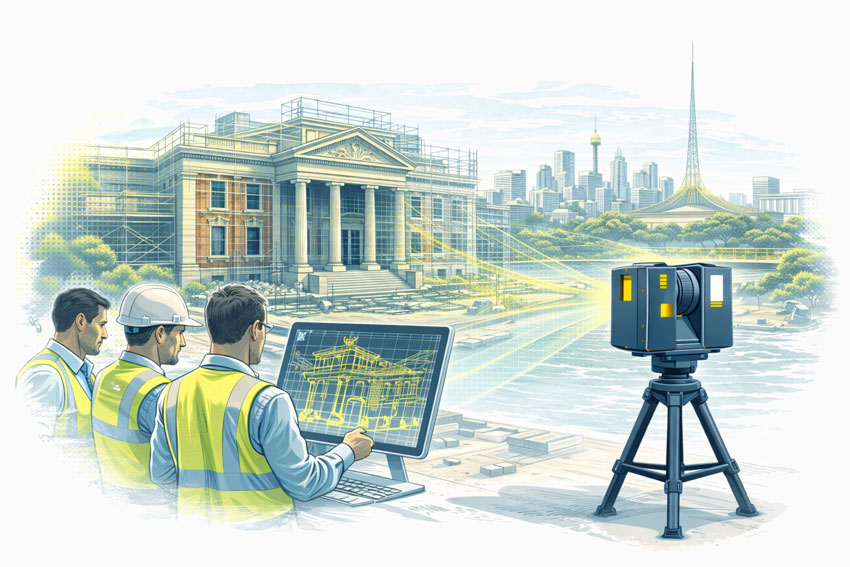
Engineering-led reality capture, CAD modelling, and fabrication-ready design for Queensland industry
Hamilton By Design provides 3D Engineering Services in Brisbane by integrating engineering-grade reality capture, mechanical engineering, and fabrication-ready documentation into a single accountable workflow.
Our approach builds on proven internal capabilities in Reality Capture and Mechanical Engineering Services ensuring site conditions are accurately understood before design decisions are finalised and steel is cut.
Why 3D engineering services are critical for Brisbane-managed projects
Many industrial and infrastructure projects managed from Brisbane involve brownfield assets, constrained access, and remote delivery locations. In these environments, incomplete information quickly leads to design risk.
Common challenges include:
Outdated or missing as-built documentation
Unknown interfaces between new and existing assets
Limited opportunities for repeat site access
Fabrication errors identified during installation
High rework and logistics costs for regional Queensland projects
can accurately capture site geometry, true risk reduction only occurs when this data is interpreted through an engineering-led process. This is why Hamilton By Design focuses on Engineering-Grade Laser Scanning rather than survey-only or visual-only capture.
What we mean by “3D Engineering Services”
At Hamilton By Design, 3D Engineering Services represent the integration of:
Verified site reality
Mechanical engineering judgement
Fabrication-driven design intent
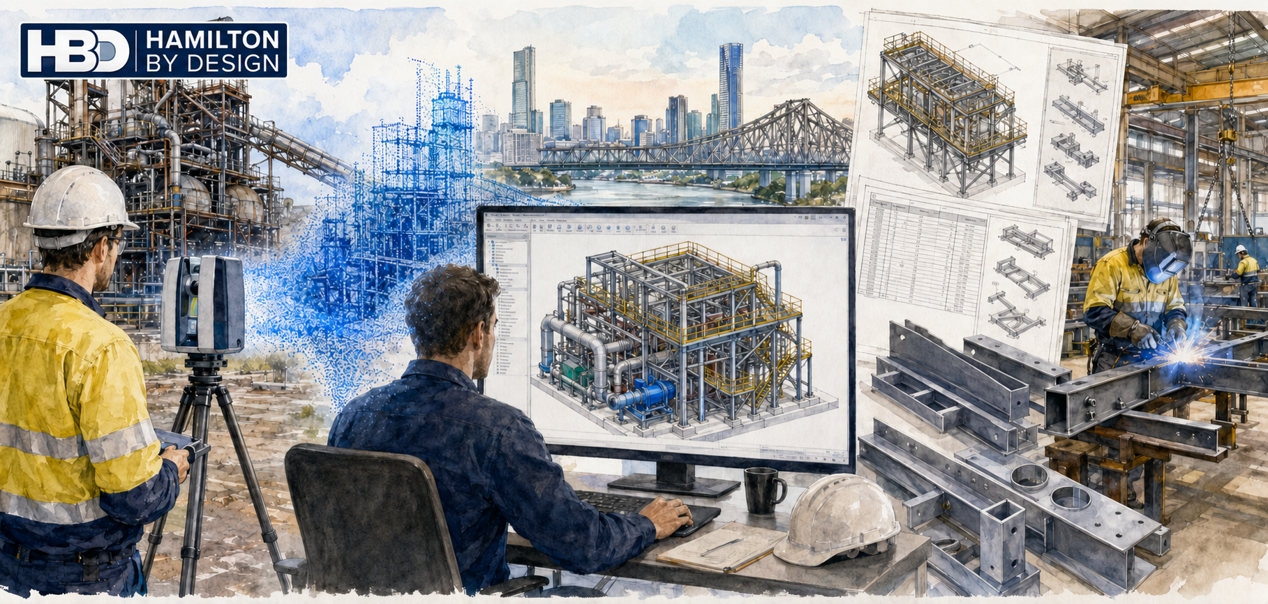
Point clouds are not treated as visual references. Instead, they are converted into engineering-grade CAD through our Point cloud to CAD modelling process using Solidworks CAD Modelling that reflect true as-built conditions, tolerances, and identifying interfaces.
This approach differentiates our services from marketing scans, survey deliverables without engineering accountability, and drafting workflows disconnected from site reality.
The Hamilton By Design 3D engineering workflow
Our Brisbane-based services follow a structured workflow designed to protect downstream fabrication and installation.
Captured data is reviewed and validated to ensure it is suitable for engineering interpretation rather than visualisation alone.
Point cloud to SolidWorks CAD modelling
Verified site data is translated into SolidWorks CAD models representing real-world geometry and constraints.
Engineering interpretation and validation
Models are assessed with consideration of load paths, tolerances, clearances, and installation constraints.
Fabrication-ready deliverables
Design outputs are prepared for shop-floor use via our fabrication support services</a>, including general arrangement drawings, detailed fabrication drawings, bills of materials, and digital QA models.
Core 3D engineering services delivered in Brisbane
Hamilton By Design provides:
Engineering-grade LiDAR and laser scanning
Point cloud to CAD modelling
Mechanical design and brownfield plant upgrades
Structural steel modelling and verification
Interface and clearance checks
Fabrication drawings and BOMs
Digital QA and clash detection
As-built documentation
Each service is delivered as part of an integrated engineering workflow designed to eliminate ambiguity before fabrication begins.
Brisbane as an engineering coordination hub for Queensland
Brisbane serves as a central coordination hub for industrial projects delivered across Queensland, including mining, energy, port, and regional processing facilities.
Hamilton By Design supports Brisbane-managed projects across:
Bowen Basin
Surat Basin
Gladstone
Townsville
Mount Isa
For resource-sector projects, our experience in mechanical engineering for the mining industry ensures designs remain practical, buildable, and aligned with site conditions.
Industries and assets supported
Industries
Mining and mineral processing
CHPP and bulk materials handling
Energy and utilities
Ports and logistics
Industrial manufacturing
Asset types
Conveyor systems and transfer chutes
Structural steel platforms and walkways
Pipework and mechanical assemblies
Brownfield plant upgrades
Temporary and permanent industrial structures
Our capability in structural engineering supports projects where compliance, load paths, and interfaces must be verified before fabrication.
Why Hamilton By Design
Clients engage Hamilton By Design for engineering accountability, not just technology.
Our key points of difference include:
Engineer-led scanning workflows
Single point of responsibility from scan to drawings
Mechanical-engineering-driven modelling
Fabrication-first mindset
Alignment with Australian engineering standards
Practical understanding of site and installation constraints
Our broader engineering services are designed to reduce rework, improve confidence, and protect project budgets.
Discuss a Brisbane-managed project
If you are managing an industrial or infrastructure project from Brisbane and require engineering-grade 3D data to support design, fabrication, or upgrade works, Hamilton By Design can assist.
Early engagement ensures site reality is embedded into the engineering process—reducing risk and improving project certainty.
To provide the best experiences, we use technologies like cookies to store and/or access device information. Consenting to these technologies will allow us to process data such as browsing behaviour or unique IDs on this site. Not consenting or withdrawing consent, may adversely affect certain features and functions.
Functional
Always active
The technical storage or access is strictly necessary for the legitimate purpose of enabling the use of a specific service explicitly requested by the subscriber or user, or for the sole purpose of carrying out the transmission of a communication over an electronic communications network.
Preferences
The technical storage or access is necessary for the legitimate purpose of storing preferences that are not requested by the subscriber or user.
Statistics
The technical storage or access that is used exclusively for statistical purposes.The technical storage or access that is used exclusively for anonymous statistical purposes. Without a subpoena, voluntary compliance on the part of your Internet Service Provider, or additional records from a third party, information stored or retrieved for this purpose alone cannot usually be used to identify you.
Marketing
The technical storage or access is required to create user profiles to send advertising, or to track the user on a website or across several websites for similar marketing purposes.