


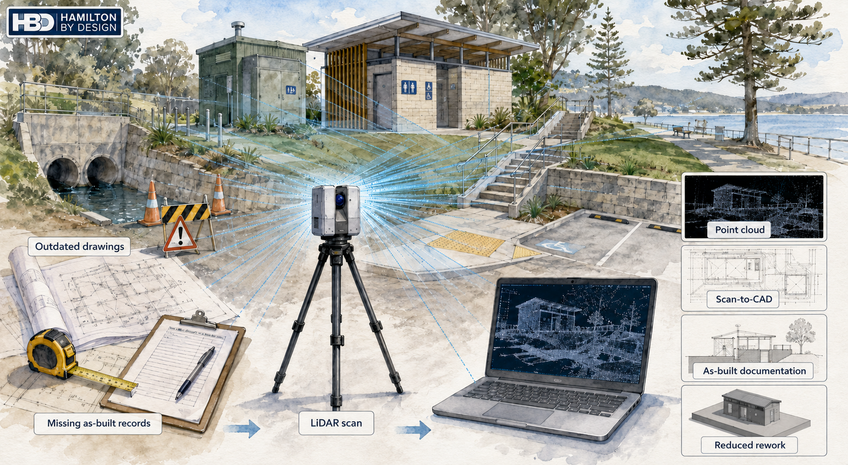

Councils manage a wide range of public infrastructure. This includes stormwater assets, pump stations, amenities buildings, carparks, parks, depots, retaining walls, roads, footpaths, coastal assets, water infrastructure and community facilities.
Many of these assets have been modified over time. Drawings may be outdated, site conditions may have changed, and important details may be missing from the original records.
Before a council, consultant or contractor can confidently plan an upgrade, maintenance project or renewal program, they need accurate existing-condition information.
This is where LiDAR scanning for council infrastructure can help.
LiDAR scanning captures accurate 3D site data and converts the real-world environment into a digital point cloud. From that point cloud, useful engineering outputs can be created, including CAD drawings, sections, elevations, 3D models and as-built documentation.
For councils, this means better information before design, procurement, construction and long-term asset management decisions are made.
Why Councils Need Accurate Existing-Condition Data
Public assets are often difficult to document properly using manual measurement alone.
A stormwater outlet may have irregular geometry. A pump station may contain pipework, valves, platforms and access constraints. A public amenities building may have been altered several times. A depot or workshop may have services, equipment and structures that are not shown correctly on old drawings.
When project teams rely on incomplete information, the risk increases.
Common problems include:
- Design assumptions based on outdated drawings
- Contractors needing repeated site visits
- Fabrication errors caused by incorrect measurements
- Poor tender information
- Unexpected clashes during construction
- Missing as-built records
- Difficulty planning maintenance or renewals
- Higher risk of rework and delay
LiDAR scanning helps reduce these problems by capturing the existing asset before work begins.
Where LiDAR Scanning Helps Council Projects
| Council Asset | How LiDAR Scanning Helps |
|---|---|
| Stormwater pits, culverts and outlets | Captures existing geometry, levels, surrounding constraints and access conditions |
| Pump stations and water assets | Documents pipework, valves, platforms, equipment, clearances and structures |
| Public amenities buildings | Supports refurbishment, accessibility upgrades and as-built plans |
| Carparks and access roads | Captures kerbs, ramps, barriers, drainage and layout constraints |
| Parks and open space assets | Helps with renewal planning, pathways, ramps and public access improvements |
| Depots and workshops | Records existing layouts, equipment zones, services and structures |
| Retaining walls and access stairs | Supports condition review, replacement planning and design checks |
| Coastal and foreshore assets | Useful for localised structure, access and public asset documentation |
| Bridges and small structures | Captures visible geometry for upgrade planning and design coordination |
What Hamilton By Design Delivers
Hamilton By Design provides engineering-led LiDAR scanning and scan-to-CAD services for councils, consultants and contractors working on public infrastructure and asset renewal projects.
Depending on the project, deliverables may include:
- Registered point cloud data
- 2D CAD plans
- Sections and elevations
- 3D CAD models
- Existing-condition drawings
- As-built documentation
- Mechanical and structural layout models
- Site constraint records
- Design verification data
- Fabrication and upgrade support
The value is not just in capturing the scan. The real value is turning the point cloud into information that engineers, asset managers, designers and contractors can actually use.
Choosing the Right Scanning Method
Not every LiDAR method suits every council project.
Some projects need detailed terrestrial scanning of a pump station, public building, depot or stormwater structure. Other projects may need drone survey, mobile mapping, broad topographic data or input from a registered surveyor.
Hamilton By Design focuses on selecting the right capture method for the project outcome, rather than forcing one scanning approach onto every site.
Best Fit for LiDAR Scanning
| Best Fit | May Need Another Method |
|---|---|
| Pump station upgrades | Whole-catchment flood mapping |
| Public amenities refurbishments | Legal boundary survey |
| Stormwater outlet replacements | Underground service locating |
| Depot and workshop layouts | Large road corridor mapping |
| Small bridges and culverts | Full cadastral survey |
| Retaining walls and stairs | Deep geotechnical investigation |
| Brownfield facility upgrades | Broad aerial terrain mapping |
LiDAR scanning is best used where accurate visible existing conditions matter.
It is not a replacement for every survey method, but it is a powerful tool for reducing uncertainty before design and construction begin.
Advantages of LiDAR Scanning for Councils
| Advantage | Council Benefit |
|---|---|
| Better existing-condition data | Reduces assumptions before design starts |
| Fewer site revisits | Saves time for council staff, consultants and contractors |
| Improved tender information | Helps contractors price from clearer site data |
| Reduced rework | Helps avoid clashes, wrong dimensions and incorrect fabrication |
| Better asset records | Supports future maintenance and asset management |
| Safer site capture | Reduces manual measuring in difficult or awkward areas |
| Faster design coordination | Allows multiple stakeholders to work from the same site record |
| Stronger project evidence | Creates a digital record of what existed at the time of capture |
Quick Project Matching Guide
| If You Are Planning | Ask About |
|---|---|
| A pump station upgrade | LiDAR scanning and scan-to-CAD modelling |
| A stormwater outlet replacement | Existing-condition capture and sections |
| A public amenities refurbishment | As-built plans and 3D building capture |
| A depot layout change | Point cloud modelling and clearance checks |
| A retaining wall replacement | Existing geometry and access documentation |
| A contractor tender package | Scan data, CAD drawings and site constraints |
| A council asset renewal program | Repeatable asset capture workflow |
LiDAR Scanning for Central Coast Council-Style Projects
Central Coast Council already publishes references to LiDAR in areas such as flood studies, coastal monitoring and dredging programs. This shows that LiDAR is already part of modern infrastructure, environmental and asset-related work.
The opportunity now is to apply the same digital capture thinking to smaller, asset-level projects such as pump stations, public buildings, stormwater assets, depots, carparks, retaining walls and local infrastructure upgrades.
For council-style projects, accurate site data can help answer important questions early:
- What is actually on site?
- Do the old drawings match reality?
- Where are the access constraints?
- What will the contractor need to work around?
- Can the proposed design fit the existing asset?
- What information should be included in the tender package?
- What should be recorded for future asset management?
FAQs
What is LiDAR scanning for council infrastructure?
LiDAR scanning captures accurate 3D site data that can be used to create point clouds, CAD drawings, models and as-built documentation for public assets.
Can LiDAR scanning replace a registered surveyor?
No. LiDAR scanning can support engineering and asset documentation, but cadastral boundaries, legal survey and certified survey work must be completed by an appropriately qualified surveyor.
What council assets can be scanned?
Stormwater assets, pump stations, public buildings, amenities, depots, retaining walls, carparks, pathways, access structures and brownfield infrastructure can often be scanned.
Is LiDAR useful for stormwater works-as-executed records?
Yes. LiDAR can help capture existing drainage geometry and surrounding site conditions, although final works-as-executed requirements should match the relevant council specification.
What is the difference between LiDAR scanning and scan-to-CAD?
LiDAR scanning captures the site. Scan-to-CAD converts the point cloud into useful drawings, models, sections or design-ready geometry.
When is LiDAR scanning not the right tool?
It may not be the best option for simple measurements, legal boundaries, buried services, whole-region mapping or very large open terrain projects unless combined with other survey methods.
Need LiDAR Scanning for a Council Infrastructure Project?
Hamilton By Design provides engineering-led LiDAR scanning, point cloud modelling and scan-to-CAD services for council infrastructure, public assets and brownfield upgrade projects across the Central Coast, Hunter, Sydney and regional NSW.
If your project needs accurate existing-condition data before design, tendering or construction, we can help turn the real site into usable engineering information.
Talk to Us – Contact Us
Our clients:
























