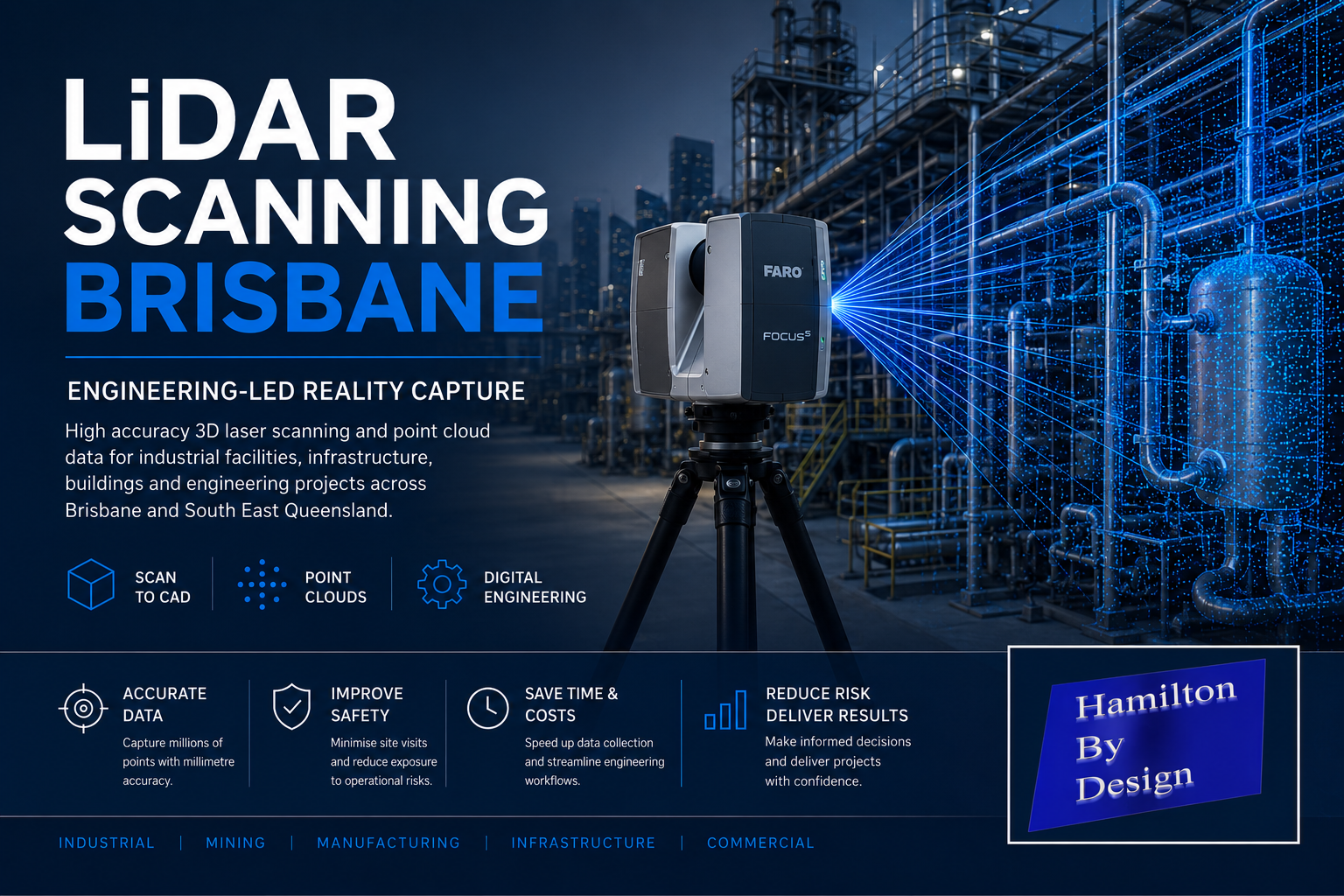
LiDAR Scanning Brisbane – Engineering-Led 3D Laser Scanning & Digital Engineering Services
LiDAR Scanning Brisbane

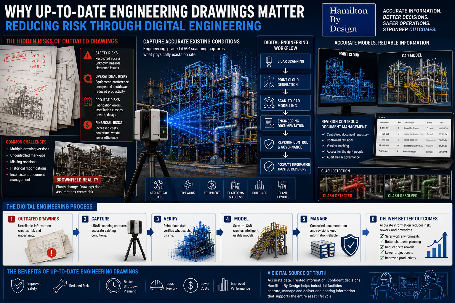
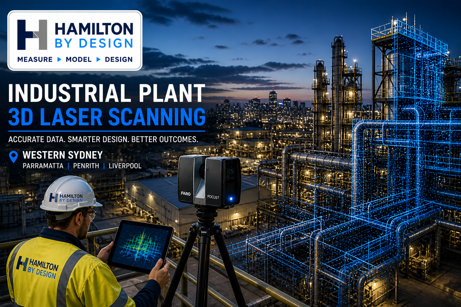
Hamilton By Design provides engineering-led LiDAR scanning services throughout Brisbane and South East Queensland, delivering accurate point cloud data for industrial facilities, mining infrastructure, manufacturing plants, commercial buildings, water treatment facilities and large-scale engineering projects.
Unlike traditional survey-only providers, our team combines practical mechanical engineering, drafting and digital engineering experience with advanced terrestrial laser scanning technology. This allows us to capture existing conditions quickly and accurately while understanding how the data will be used during engineering design, shutdown planning, asset management and construction projects.
Whether you require a simple Scan to CAD deliverable or a complete digital engineering solution, our Brisbane LiDAR scanning services provide a reliable foundation for project success.
What is LiDAR Scanning?
LiDAR (Light Detection and Ranging) is a technology that uses laser pulses to measure millions of points in three-dimensional space. The result is a highly detailed digital representation of an asset, structure or facility known as a point cloud.
LiDAR scanning can accurately capture:
- Structural steelwork
- Mechanical equipment
- Pipework systems
- Conveyors and materials handling systems
- Processing plants
- Buildings and facilities
- Platforms, stairs and access systems
- Tanks and pressure vessels
- Mining and mineral processing infrastructure
The collected data can then be converted into engineering drawings, 3D CAD models, BIM models and asset management information.
Engineering-Led LiDAR Scanning
At Hamilton By Design, LiDAR scanning is supported by real engineering experience.
Our team has experience across:
- Mechanical engineering
- Structural drafting
- Pipework drafting
- Materials handling systems
- Smelters and refineries
- Coal handling and preparation plants (CHPP)
- Mining infrastructure
- Manufacturing facilities
- Water and wastewater treatment plants
- Industrial shutdown projects
Because we understand how engineering information is used, we focus on capturing the information required for successful project delivery rather than simply collecting point cloud data.
LiDAR Scanning Applications
Industrial Facilities
Capture complete facilities for future engineering, expansion projects and asset management.
Mechanical Engineering
Generate accurate as-built information for equipment upgrades, maintenance planning and reverse engineering projects.
Structural Drafting
Produce existing structural steel models and detailed drafting for modifications and compliance assessments.
Pipework Design
Create accurate pipe routing models and clash detection studies before fabrication and installation.
Construction Verification
Verify installed works against design models and identify deviations before project completion.
Shutdown Planning
Reduce site visits and improve engineering productivity by creating a digital twin of the facility.
Scan to CAD Brisbane
Our Scan to CAD services transform LiDAR point cloud data into usable engineering deliverables including:
- AutoCAD drawings
- General arrangement drawings
- Floor plans
- Sections and elevations
- Structural steel models
- Mechanical equipment models
- Pipework models
- Inventor models
- SolidWorks models
- STEP and SAT files
This process enables engineering teams to work from accurate existing conditions while reducing project risk.
Benefits of LiDAR Scanning
Improved Safety
Reduce the need for repeated site access and minimise exposure to operational hazards.
Increased Accuracy
Capture millions of measurements with engineering-grade accuracy.
Reduced Project Risk
Identify clashes, access issues and existing site constraints before design begins.
Faster Project Delivery
Engineering teams can work from a complete digital record rather than relying on manual measurements.
Future-Proof Asset Information
Create a permanent digital record for future maintenance, upgrades and expansion projects.
Brisbane Industries We Support
Hamilton By Design supports projects throughout Brisbane and South East Queensland including:
- Mining and mineral processing
- Smelting and refining
- Power generation
- Water and wastewater treatment
- Manufacturing
- Food and beverage processing
- Ports and logistics
- Infrastructure projects
- Commercial buildings
- Government assets
We regularly support projects throughout:
- Brisbane CBD
- Eagle Farm
- Pinkenba
- Lytton
- Port of Brisbane
- Ipswich
- Logan
- Redcliffe
- Caboolture
- Toowoomba
- Gold Coast
- Sunshine Coast
Deliverables
Typical deliverables include:
- Registered point clouds (E57, RCP, RCS, LAS)
- Scan to CAD models
- AutoCAD drawings
- Structural drafting packages
- Mechanical drafting packages
- Pipework models
- As-built verification reports
- BIM models
- Clash detection studies
- Engineering support documentation
Why Choose Hamilton By Design?
Hamilton By Design combines practical trade experience, engineering expertise and advanced LiDAR technology to deliver real-world outcomes for industrial projects.
Our team brings experience as:
- Mechanical Engineers
- Draftspersons
- Fitters and Turners
- Site-based Engineering Personnel
- Project Leaders
- Digital Engineering Specialists
This combination allows us to understand both the physical asset and the engineering requirements behind every project.

LiDAR Scanning Brisbane – Get Started
Whether you require a one-day site scan, a complete facility capture or an engineering-led digital twin solution, Hamilton By Design can provide accurate and reliable LiDAR scanning services throughout Brisbane and Southeast Queensland.
Contact Hamilton By Design today to discuss your LiDAR scanning, Scan to CAD, structural drafting, mechanical drafting and digital engineering requirements.
Contact Us – Talk to Us
Our Clients