At Hamilton By Design, technology investments are made with one objective in mind: delivering practical engineering outcomes for our clients.
Over the years, the reality capture market has expanded significantly, with a wide range of terrestrial scanners, mobile mapping systems, handheld scanners and metrology solutions available. While each technology has its place, we have chosen to build our reality capture and reverse engineering workflow around the FARO ecosystem because it aligns closely with the work we perform every day.
Our projects typically involve industrial facilities, mining infrastructure, manufacturing plants, process equipment, structural steel, pipework systems, shutdown planning, reverse engineering and Scan-to-CAD workflows. These applications require more than point cloud collection. They require engineering-grade information that can be transformed into practical deliverables.
A Complete Measurement Ecosystem
One of the key strengths of FARO is the breadth of its measurement portfolio.
The FARO platform spans multiple levels of measurement capability:
Large-Scale Reality Capture
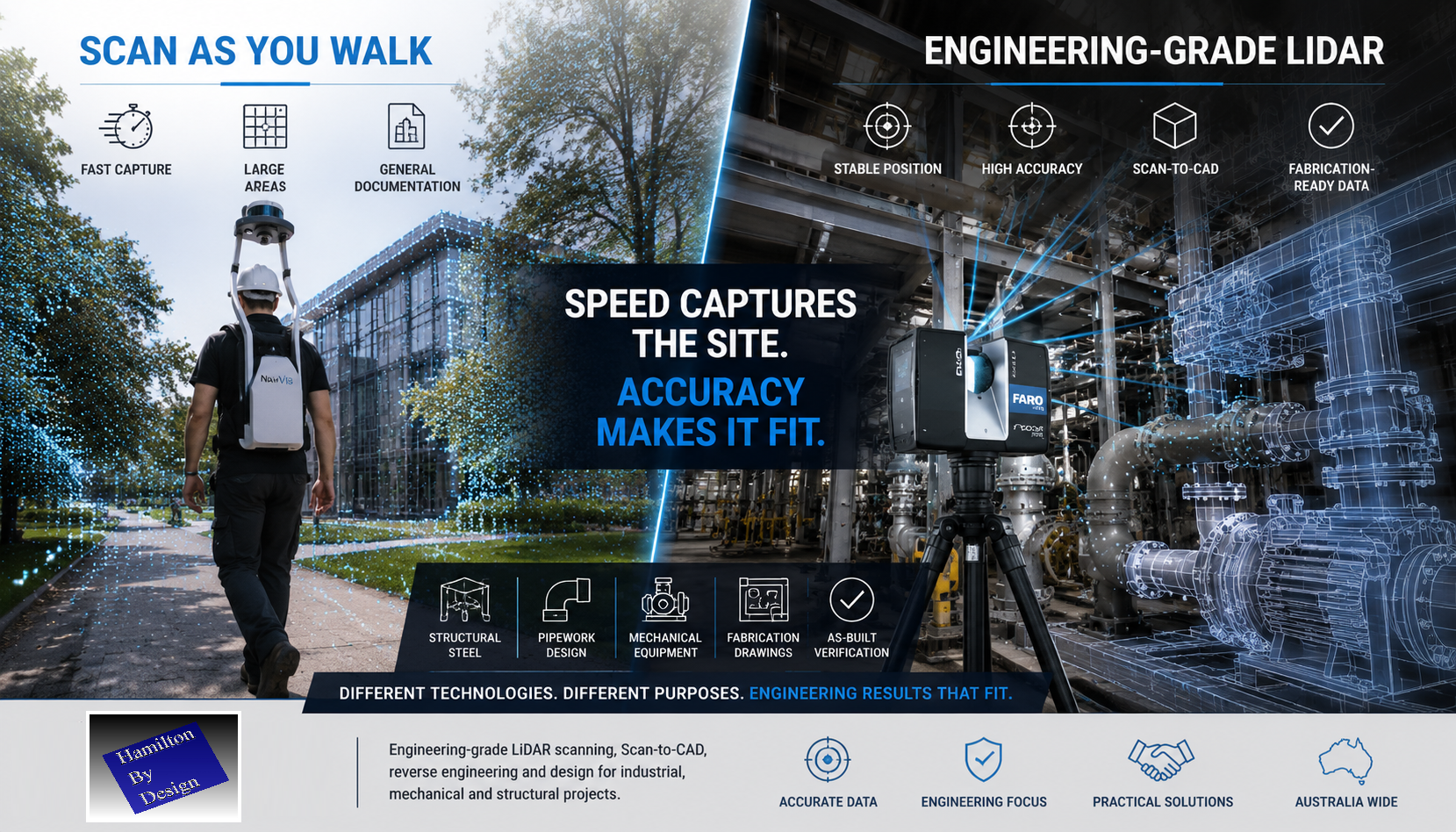
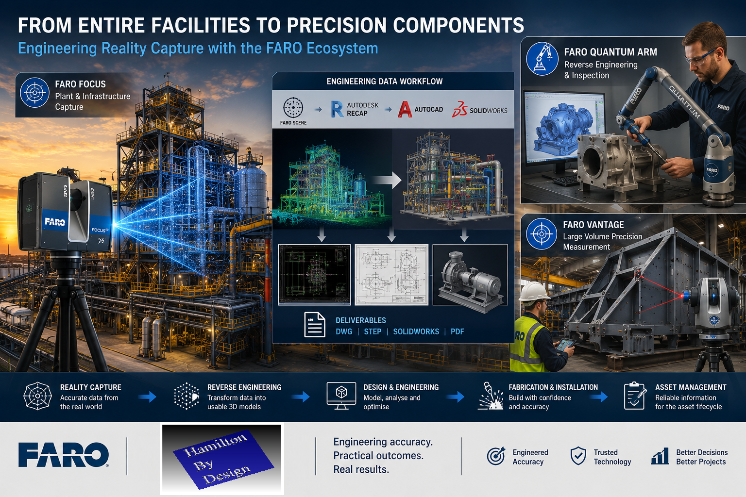
The FARO Focus Series provides terrestrial laser scanning solutions capable of capturing facilities ranging from small plant rooms through to large industrial complexes and infrastructure projects.
These systems allow engineers to capture existing conditions with confidence while generating data suitable for:
- Scan-to-CAD
- Digital twins
- Asset management
- Plant modifications
- Structural steel detailing
- Mechanical design
- Construction verification
Mobile Reality Capture
The FARO Orbis platform introduces mobile mapping capability while remaining connected to the wider FARO ecosystem.
For large facilities requiring rapid data acquisition, mobile scanning provides an efficient solution while maintaining compatibility with engineering workflows.
Portable Metrology
The FARO Quantum Arm extends capability beyond facility measurement into precision engineering applications.
This allows organisations to move seamlessly from measuring an entire processing plant to inspecting a single component with metrology-grade accuracy.
Applications include:
- Reverse engineering
- Quality control
- Manufacturing inspection
- Component verification
- Precision measurement
Large Volume Precision Measurement
The FARO Vantage Laser Tracker platform provides another layer of capability for applications requiring high accuracy over large distances.
Industries including aerospace, power generation, heavy manufacturing and industrial construction rely on this technology for alignment and verification tasks where traditional surveying methods may not provide the required level of precision.
Engineering Integration Matters
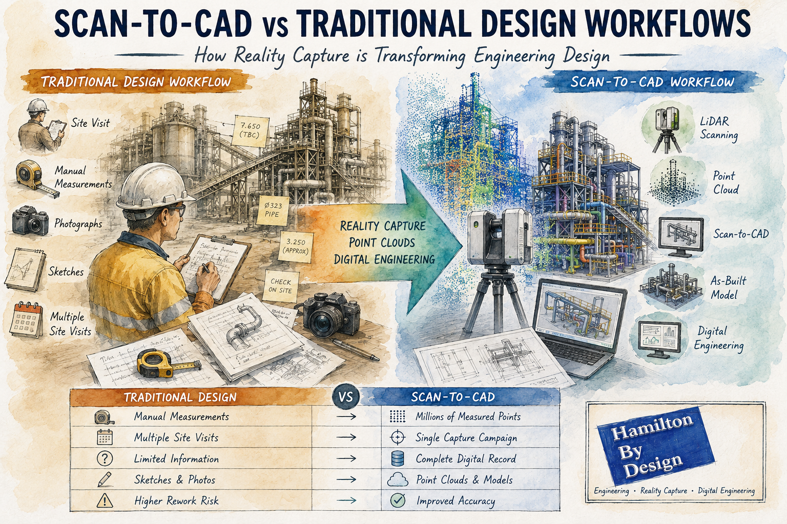
For Hamilton By Design, scanning is not the final deliverable.
The point cloud is only the beginning of the engineering process.
Our clients generally require:
- AutoCAD models
- SolidWorks models
- STEP files
- Fabrication drawings
- General arrangement drawings
- Structural steel details
- Mechanical engineering documentation
Because of this, we place significant value on workflows that integrate effectively with engineering software.
Our reality capture workflow commonly includes:
- FARO Focus
- FARO SCENE
- Autodesk ReCap
- AutoCAD
- SolidWorks
- Navisworks
This enables captured information to move efficiently from the field into engineering and manufacturing environments.
From Entire Facilities to Individual Components
One of the reasons the FARO ecosystem is particularly attractive for engineering organisations is its scalability.
A single project may involve:
- Scanning an entire processing plant using a FARO Focus scanner.
- Measuring a critical pump housing using a FARO Arm.
- Verifying installation geometry using a FARO Laser Tracker.
- Delivering engineering models through AutoCAD and SolidWorks.
All of these activities can occur within a connected measurement ecosystem.
This capability allows engineers to select the most appropriate tool for each measurement challenge rather than forcing every project into a single workflow.
Supporting Industrial Engineering Projects
Hamilton By Design operates primarily within industrial environments.
Typical projects include:
- Mining operations
- Mineral processing facilities
- Manufacturing plants
- Conveyor systems
- Chute and hopper design
- Pipework modifications
- Structural steel upgrades
- Shutdown planning
- Reverse engineering of legacy equipment
These projects require practical engineering solutions supported by reliable measurement data.
The FARO ecosystem provides a range of tools capable of supporting these requirements, from large-scale reality capture through to precision metrology.
Engineering-Led Reality Capture
Technology alone does not guarantee project success.
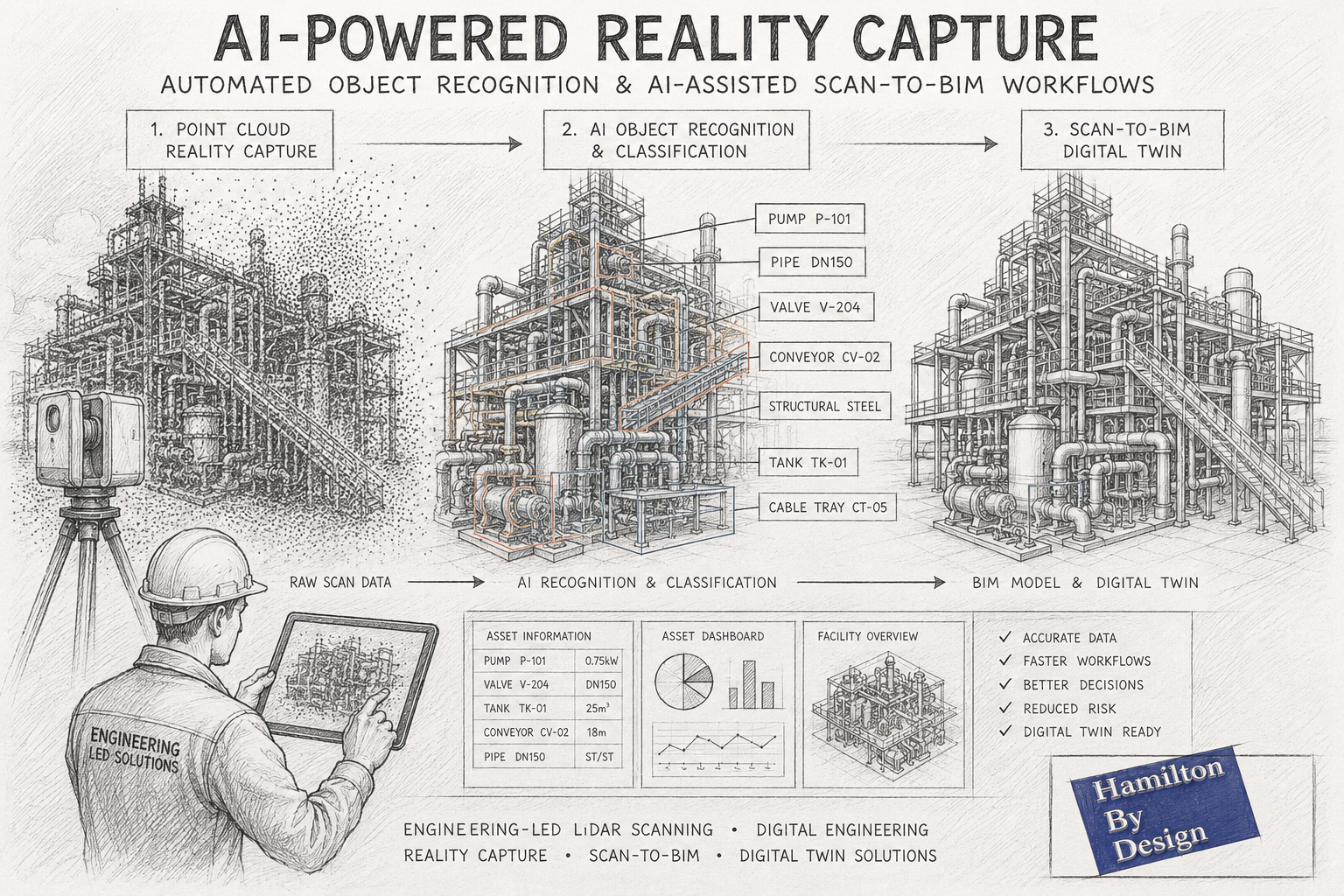
The value of reality capture comes from the ability to transform measurement data into actionable engineering information.
At Hamilton By Design, our objective is not simply to collect point clouds. Our objective is to help clients make informed engineering decisions, reduce project risk, improve constructability and accelerate project delivery.
The FARO ecosystem supports this objective by providing measurement solutions that span reality capture, mobile mapping, portable metrology and large-volume precision measurement.
For engineering organisations seeking a scalable measurement platform capable of supporting projects from facility-scale scanning through to component-level verification, FARO continues to provide one of the most comprehensive portfolios available within the industry.
By combining proven measurement technology with practical engineering expertise, Hamilton By Design delivers reality capture solutions that move beyond visualisation and into real-world engineering outcomes.
Why Hamilton By Design Has Invested in the FARO Ecosystem
At Hamilton By Design, technology investments are made with one objective in mind: delivering practical engineering outcomes for our clients.
Over the years, the reality capture market has expanded significantly, with a wide range of terrestrial scanners, mobile mapping systems, handheld scanners and metrology solutions available. While each technology has its place, we have chosen to build our reality capture and reverse engineering workflow around the FARO ecosystem because it aligns closely with the work we perform every day.
Our projects typically involve industrial facilities, mining infrastructure, manufacturing plants, process equipment, structural steel, pipework systems, shutdown planning, reverse engineering and Scan-to-CAD workflows. These applications require more than point cloud collection. They require engineering-grade information that can be transformed into practical deliverables.
A Complete Measurement Ecosystem
One of the key strengths of FARO is the breadth of its measurement portfolio.
The FARO platform spans multiple levels of measurement capability:
Large-Scale Reality Capture
The FARO Focus Series provides terrestrial laser scanning solutions capable of capturing facilities ranging from small plant rooms through to large industrial complexes and infrastructure projects.
These systems allow engineers to capture existing conditions with confidence while generating data suitable for:
- Scan-to-CAD
- Digital twins
- Asset management
- Plant modifications
- Structural steel detailing
- Mechanical design
- Construction verification
Mobile Reality Capture
The FARO Orbis platform introduces mobile mapping capability while remaining connected to the wider FARO ecosystem.
For large facilities requiring rapid data acquisition, mobile scanning provides an efficient solution while maintaining compatibility with engineering workflows.
Portable Metrology
The FARO Quantum Arm extends capability beyond facility measurement into precision engineering applications.
This allows organisations to move seamlessly from measuring an entire processing plant to inspecting a single component with metrology-grade accuracy.
Applications include:
- Reverse engineering
- Quality control
- Manufacturing inspection
- Component verification
- Precision measurement
Large Volume Precision Measurement
The FARO Vantage Laser Tracker platform provides another layer of capability for applications requiring high accuracy over large distances.
Industries including aerospace, power generation, heavy manufacturing and industrial construction rely on this technology for alignment and verification tasks where traditional surveying methods may not provide the required level of precision.
Engineering Integration Matters
For Hamilton By Design, scanning is not the final deliverable.
The point cloud is only the beginning of the engineering process.
Our clients generally require:
- AutoCAD models
- SolidWorks models
- STEP files
- Fabrication drawings
- General arrangement drawings
- Structural steel details
- Mechanical engineering documentation
Because of this, we place significant value on workflows that integrate effectively with engineering software.
Our reality capture workflow commonly includes:
- FARO Focus
- FARO SCENE
- Autodesk ReCap
- AutoCAD
- SolidWorks
- Navisworks
This enables captured information to move efficiently from the field into engineering and manufacturing environments.
From Entire Facilities to Individual Components
One of the reasons the FARO ecosystem is particularly attractive for engineering organisations is its scalability.
A single project may involve:
- Scanning an entire processing plant using a FARO Focus scanner.
- Measuring a critical pump housing using a FARO Arm.
- Verifying installation geometry using a FARO Laser Tracker.
- Delivering engineering models through AutoCAD and SolidWorks.
All of these activities can occur within a connected measurement ecosystem.
This capability allows engineers to select the most appropriate tool for each measurement challenge rather than forcing every project into a single workflow.
Supporting Industrial Engineering Projects
Hamilton By Design operates primarily within industrial environments.
Typical projects include:
- Mining operations
- Mineral processing facilities
- Manufacturing plants
- Conveyor systems
- Chute and hopper design
- Pipework modifications
- Structural steel upgrades
- Shutdown planning
- Reverse engineering of legacy equipment
These projects require practical engineering solutions supported by reliable measurement data.
The FARO ecosystem provides a range of tools capable of supporting these requirements, from large-scale reality capture through to precision metrology.
Engineering-Led Reality Capture
Technology alone does not guarantee project success.
The value of reality capture comes from the ability to transform measurement data into actionable engineering information.
At Hamilton By Design, our objective is not simply to collect point clouds. Our objective is to help clients make informed engineering decisions, reduce project risk, improve constructability and accelerate project delivery.
The FARO ecosystem supports this objective by providing measurement solutions that span reality capture, mobile mapping, portable metrology and large-volume precision measurement.
For engineering organisations seeking a scalable measurement platform capable of supporting projects from facility-scale scanning through to component-level verification, FARO continues to provide one of the most comprehensive portfolios available within the industry.
By combining proven measurement technology with practical engineering expertise, Hamilton By Design delivers reality capture solutions that move beyond visualisation and into real-world engineering outcomes.


Would you like to know more ?
Contact Us – Talk to Us
Our Clients