Smelter 3D LiDAR Scanning Services Newcastle NSW

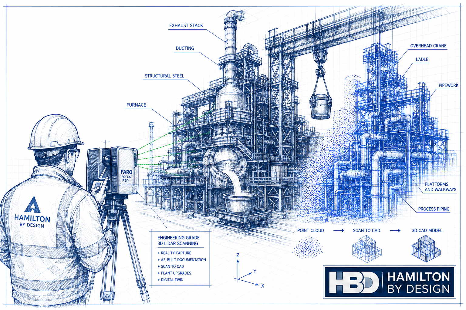
Technical blueprint illustration of a smelter facility in Newcastle NSW being captured with a FARO Focus S70 LiDAR scanner, showing point cloud reality capture, Scan to CAD conversion and engineering-grade as-built documentation for brownfield plant upgrades.

Smelter 3D LiDAR Scanning Services in Newcastle NSW
Blue line-art icon of an industrial smelting furnace pouring molten metal into a ladle, representing engineering-grade 3D LiDAR scanning services for smelters, brownfield plant upgrades and as-built documentation.

Many smelter facilities throughout Newcastle NSW have been operating for decades. During that time, plant expansions, maintenance shutdowns, emergency repairs and equipment upgrades have gradually changed the facility from its original design. Unfortunately, these changes are not always reflected in the engineering drawings.

The result is a common challenge faced by plant owners and engineering teams: the existing drawings no longer accurately represent what is installed on site.

This creates unnecessary risk during every engineering project. Pipework clashes with new equipment, structural steel connections differ from the drawings, platforms have been modified, cable trays have been rerouted, and access ways no longer match historical documentation.

Hamilton By Design provides Smelter 3D LiDAR Scanning Services in Newcastle NSW, delivering engineering-grade reality capture that allows project teams to work from accurate as-built information rather than outdated drawings. Using our 3D Laser Scanning Services, we capture millions of measurements across existing facilities and convert this information into engineering-ready point clouds, CAD models and digital as-built documentation.

Whether your project involves a shutdown, brownfield expansion, equipment replacement or complete plant upgrade, accurate site data is the foundation of successful engineering.


Why Existing Drawings Become Unreliable

Few industrial facilities remain unchanged over their operating life.

Most smelters have experienced numerous modifications, including:

  • New process equipment
  • Replacement pipework
  • Conveyor upgrades
  • Structural strengthening
  • Additional platforms and access ways
  • New services and cable trays
  • Dust extraction modifications
  • Pump replacements
  • Instrumentation upgrades
  • Temporary repairs that became permanent installations

While individual projects may have produced updated drawings, complete documentation is rarely maintained over several decades.

As a result, engineering teams frequently discover discrepancies only after arriving on site or during construction. These unexpected differences often lead to redesign, fabrication changes, additional site work and costly project delays.

Hamilton By Design helps eliminate this uncertainty by capturing the plant exactly as it exists today.


Engineering-Grade 3D LiDAR Scanning

Unlike traditional site measuring, terrestrial LiDAR scanning captures millions of highly accurate measurements in every scan position.

Our engineering workflow records:

  • Structural steel
  • Pipework
  • Tanks
  • Pressure vessels
  • Pumps
  • Valves
  • Conveyors
  • Chutes
  • Platforms
  • Walkways
  • Stairs
  • Handrails
  • Cable trays
  • Mechanical equipment
  • Existing foundations
  • Process buildings

This comprehensive digital record becomes the foundation for future engineering, drafting and asset management activities.

Once captured, the point cloud can be transformed into intelligent engineering models using our Scan to CAD Services, allowing designers to work efficiently from accurate digital information.


Reduce Brownfield Engineering Risk

Brownfield projects present unique engineering challenges because new equipment must integrate into an existing operating plant.

Typical risks include:

  • Unknown clearances
  • Hidden structural members
  • Pipe routing conflicts
  • Maintenance access restrictions
  • Interference with electrical services
  • Equipment clashes
  • Incorrect foundation locations

Without accurate site information, engineers are forced to make assumptions.

These assumptions often become expensive construction variations.

Hamilton By Design captures the existing plant with engineering-grade accuracy, allowing designers to verify every interface before fabrication begins. Our Brownfield Engineering Services help clients confidently integrate new equipment into existing facilities while reducing construction risk.


Support Shutdown Planning

Shutdown windows are expensive.

Every additional hour impacts production and increases contractor costs.

Accurate LiDAR scanning allows engineering teams to complete much of the design work before the shutdown begins.

Instead of relying on multiple site visits, designers work directly from the captured point cloud to develop:

  • Mechanical layouts
  • Structural modifications
  • Pipe routing
  • Equipment positioning
  • Maintenance access reviews
  • Installation sequencing

By reducing uncertainty during the design phase, shutdown activities become faster, safer and more predictable.


Accurate As-Built Documentation

One of the greatest long-term benefits of LiDAR scanning is the creation of accurate as-built documentation.

Hamilton By Design can provide:

  • Registered point clouds
  • AutoCAD drawings
  • 3D CAD models
  • SolidWorks assemblies
  • Autodesk Inventor models
  • STEP models
  • Navisworks coordination models
  • Structural steel models
  • Equipment models
  • General arrangement drawings
  • Engineering verification models

These deliverables provide a reliable engineering record that can be reused for future projects, maintenance planning and asset management.


Improve Design Accuracy

Engineering design is only as accurate as the information used to create it.

By working from an accurate point cloud, engineers can confidently design:

  • Replacement conveyors
  • Pipework systems
  • Pump installations
  • Structural platforms
  • Maintenance access systems
  • Mechanical upgrades
  • Process equipment
  • Tank modifications
  • Support steel
  • Ducting systems

This greatly reduces the need for redesign during construction.


Digital Twins for Smelter Facilities

Many industrial operators are now investing in digital engineering workflows.

A high-quality LiDAR scan forms the basis of a digital twin by accurately representing the current physical condition of the facility.

A digital twin can support:

  • Asset management
  • Future expansions
  • Shutdown planning
  • Maintenance strategies
  • Engineering studies
  • Safety assessments
  • Training
  • Plant familiarisation

Instead of relying on incomplete drawings, engineers have access to a complete digital representation of the plant.


Typical Areas We Scan

Hamilton By Design provides LiDAR scanning throughout industrial smelter facilities, including:

  • Ore handling systems
  • Crushing areas
  • Conveyors
  • Transfer towers
  • Smelting furnace buildings
  • Casting facilities
  • Refining areas
  • Pipe racks
  • Cooling water systems
  • Structural steel
  • Dust extraction systems
  • Process pipework
  • Pump stations
  • Tank farms
  • Workshops
  • Compressor rooms
  • Electrical substations
  • Cable tray systems
  • Access platforms
  • Walkways
  • Stair systems

Our approach ensures all critical engineering interfaces are captured for future design work.


Engineering-Led Scan-to-CAD Services

Hamilton By Design is more than a scanning provider.

As a mechanical engineering consultancy, we understand how captured data will be used during design, drafting and construction.

Our services include:

  • Engineering drafting
  • Mechanical design
  • Structural steel detailing
  • Scan-to-CAD conversion
  • Reverse engineering
  • Plant layout development
  • As-built verification
  • Brownfield engineering support
  • 3D modelling
  • Engineering documentation

Because scanning and engineering are delivered together, the final outputs are tailored to the needs of designers, fabricators and asset owners.

If replacement components need to be recreated where original OEM drawings no longer exist, our Reverse Engineering Services provide accurate engineering models developed directly from LiDAR scan data.

For clients requiring complete engineering support beyond scanning, our Mechanical Engineering Services deliver practical solutions from concept design through to detailed drafting and fabrication documentation.


Why Newcastle NSW?

Newcastle has a long history of heavy industry, steel manufacturing, minerals processing and industrial engineering. Many facilities have evolved through decades of operational improvements, making accurate engineering documentation increasingly important.

LiDAR scanning provides a practical solution for organisations managing ageing infrastructure by creating a reliable digital record of current plant conditions.

Whether the project involves equipment replacement, structural modifications, shutdown planning or long-term asset management, engineering teams benefit from working with accurate, up-to-date information rather than relying on historical drawings.


Why Choose Hamilton By Design?

Hamilton By Design combines advanced terrestrial LiDAR scanning technology with practical engineering experience.

Our clients value our ability to deliver:

  • Engineering-grade LiDAR scanning
  • Accurate as-built documentation
  • Brownfield engineering support
  • Scan-to-CAD modelling
  • Mechanical engineering expertise
  • Structural modelling
  • Reverse engineering
  • Shutdown planning assistance
  • High-quality engineering documentation

We understand the demands of operating industrial facilities and the importance of delivering information that engineers can confidently use for design, fabrication and construction.


Hamilton By Design logo displayed on a blue tilted rectangle with a grey gradient background

Ready to Modernise Your Smelter Documentation?

If your smelter drawings no longer reflect the current plant, now is the time to create an accurate digital record.

Hamilton By Design provides Smelter 3D LiDAR Scanning Services in Newcastle NSW, helping industrial operators reduce brownfield engineering risk, improve shutdown planning and develop reliable as-built documentation for future projects.

Whether you require a single process area, a complete facility scan or ongoing engineering support, our team can deliver engineering-grade reality capture tailored to your project requirements.

Contact Hamilton By Design today to discuss your next smelter upgrade, shutdown or brownfield engineering project and discover how engineering-grade LiDAR scanning can reduce project risk while improving design accuracy.

Talk to Us – Contact Us

Name
Would you like us to arrange a phone consultation for you?
Address

Our clients:

https://www.hamiltonbydesign.com.au/scan-to-bim-services-australia-lidar-point-clouds-cad-modelling

Scan to BIM Perth WA

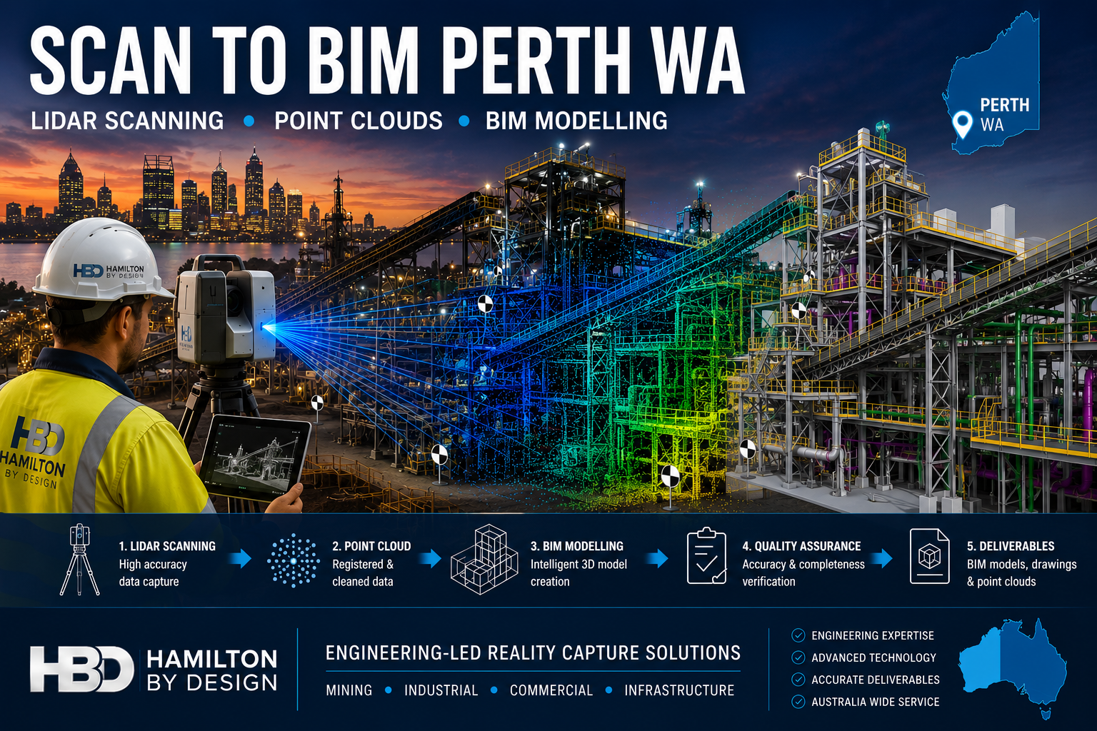
Scan to BIM Perth WA engineering workflow showing LiDAR scanning, point cloud processing and BIM modelling of a Western Australian industrial facility using Hamilton By Design reality capture services.

Scan to BIM Perth WA

Engineering-Led Scan to BIM Services Across Perth and Western Australia

Blue 3D LiDAR scanner icon on a tripod with scanning waves

Hamilton By Design provides professional Scan to BIM services throughout Perth and Western Australia, helping mining, industrial, commercial, infrastructure and construction organisations transform accurate 3D laser scan data into intelligent Building Information Models (BIM).

Using engineering-grade LiDAR scanning technology and advanced BIM workflows, we capture existing facilities, process plants, buildings and infrastructure assets and convert them into accurate digital models suitable for design, planning, construction and asset management.

Whether your project involves a brownfield mining upgrade in the Pilbara, a commercial building in the Perth CBD, a processing plant in Kwinana or infrastructure works across regional Western Australia, our Scan to BIM services deliver reliable information for better engineering and project outcomes.


What is Scan to BIM?

Scan to BIM is the process of converting 3D laser scan data into an intelligent Building Information Model.

The process begins with high-accuracy LiDAR scanning, which captures millions of measurement points across a site. This data forms a point cloud that accurately represents existing conditions.

The point cloud is then used to create a BIM model containing structural, architectural and mechanical information that can be used throughout the project lifecycle.

The result is a highly accurate digital representation of the asset that supports:

  • Engineering design
  • Construction planning
  • Asset management
  • Facility upgrades
  • Maintenance planning
  • Clash detection
  • Digital twin development

Engineering-Led BIM Modelling

Unlike many scanning providers that focus only on data capture, Hamilton By Design combines engineering experience with reality capture technology.

This means the final BIM model is developed with an understanding of:

  • Mechanical systems
  • Structural steel
  • Conveyors
  • Chutes
  • Tanks
  • Pipework
  • Platforms and access systems
  • Process equipment
  • Material handling infrastructure

Our engineering background allows us to understand how facilities operate and how accurate models can improve future design decisions.


Perth Industries Using Scan to BIM

Mining and Resources

Western Australia remains one of the world’s largest mining regions.

Scan to BIM supports:

  • Iron ore facilities
  • Gold processing plants
  • Lithium operations
  • Rare earth projects
  • Bulk material handling systems
  • Port infrastructure

Accurate BIM models help engineering teams reduce shutdown durations and improve planning for plant upgrades.


Industrial Manufacturing

Many Perth manufacturers operate facilities that have evolved over decades.

Often existing drawings are incomplete or outdated.

Scan to BIM enables:

  • Accurate facility documentation
  • Equipment replacement projects
  • Structural upgrades
  • Capacity expansion projects
  • Maintenance planning

Commercial Buildings

Commercial property owners increasingly use BIM models to manage assets.

Applications include:

  • Building refurbishment
  • Services upgrades
  • HVAC replacement
  • Tenant fit-outs
  • Facility management

Infrastructure Projects

Scan to BIM can support:

  • Rail infrastructure
  • Ports
  • Water treatment facilities
  • Pump stations
  • Utility corridors
  • Government infrastructure

Accurate BIM models reduce project risk by ensuring designs are based on real-world conditions.


Our Scan to BIM Workflow

1. Site LiDAR Scanning

We perform engineering-grade laser scanning using professional reality capture equipment.

Millions of measurement points are collected across the facility.


2. Point Cloud Registration

Individual scans are aligned and processed into a unified point cloud.

Typical deliverables include:

  • E57
  • RCP
  • RCS
  • LAS

3. BIM Model Development

The point cloud is converted into BIM geometry using industry-standard software.

Models may include:

  • Structural steel
  • Mechanical equipment
  • Pipework
  • Buildings
  • Platforms
  • Access systems

4. Quality Assurance

Models are checked against scan data to verify accuracy and completeness.


5. Deliverables

Typical outputs include:

  • Autodesk Revit Models
  • Navisworks Models
  • IFC Files
  • DWG Drawings
  • PDF Documentation
  • Point Cloud Files

Benefits of Scan to BIM

Improved Accuracy

Laser scanning captures existing conditions with significantly greater accuracy than traditional site measurement methods.

Reduced Design Risk

Design teams can work from verified information rather than assumptions.

Faster Project Delivery

Accurate digital models reduce site revisits and minimise redesign.

Better Asset Management

Facility owners gain an accurate digital representation of their assets.

Improved Collaboration

BIM models provide a common source of information for engineers, designers, contractors and asset owners.


Scan to BIM for Brownfield Mining Projects

Brownfield projects often present unique challenges.

Existing facilities may contain undocumented modifications, ageing infrastructure and limited historical records.

Scan to BIM allows engineering teams to:

  • Verify existing conditions
  • Identify clashes before construction
  • Reduce shutdown risks
  • Improve design confidence
  • Support future digital twin initiatives

For mining operations throughout Perth, the Pilbara, Goldfields and regional Western Australia, accurate BIM models can significantly improve project outcomes.


Why Choose Hamilton By Design?

Hamilton By Design combines:

โœ” Engineering Experience

โœ” LiDAR Scanning Expertise

โœ” BIM Modelling Capability

โœ” Mechanical Design Knowledge

โœ” Structural Drafting Experience

โœ” Australia-Wide Project Delivery

โœ” Mining Industry Experience

We understand both the technology and the engineering requirements behind successful Scan to BIM projects.


Hamilton By Design logo displayed on a blue tilted rectangle with a grey gradient background

Scan to BIM Perth WA

If you require Scan to BIM services in Perth or anywhere across Western Australia, Hamilton By Design can provide engineering-grade reality capture and BIM modelling solutions tailored to your project requirements.

From mining facilities and industrial plants to commercial buildings and infrastructure projects, we help organisations capture existing conditions and create accurate digital models that support safer, more efficient project delivery.

Talk to Us – Contact Us

Name
Would you like us to arrange a phone consultation for you?
Address

Our clients:

3D LiDAR Scanning Darwin for engineering surveys, laser scanning, reality capture and point cloud modelling services
3D LiDAR Scanning Australia engineering services for laser scanning, reality capture, scan-to-CAD, Scan-to-BIM and as-built documentation across Australia
3D LiDAR scanning services on the Central Coast providing engineering-grade laser scanning, point cloud capture, scan-to-CAD modelling and industrial reality capture for infrastructure and industrial projects.
3D LiDAR Scanning Perth for engineering surveys, laser scanning, reality capture and point cloud modelling services
3D LiDAR Scanning Sydney for engineering surveys, laser scanning, reality capture and point cloud modelling services
3D LiDAR Scanning Brisbane for engineering surveys, laser scanning, reality capture and point cloud modelling services
3D LiDAR Scanning Canberra for engineering surveys, laser scanning, reality capture and point cloud modelling services
3D LiDAR Scanning Newcastle for engineering surveys, laser scanning, reality capture and point cloud modelling services
3D LiDAR Scanning Adelaide for engineering surveys, laser scanning, reality capture and point cloud modelling services
https://www.hamiltonbydesign.com.au/scan-to-bim-services-australia-lidar-point-clouds-cad-modelling

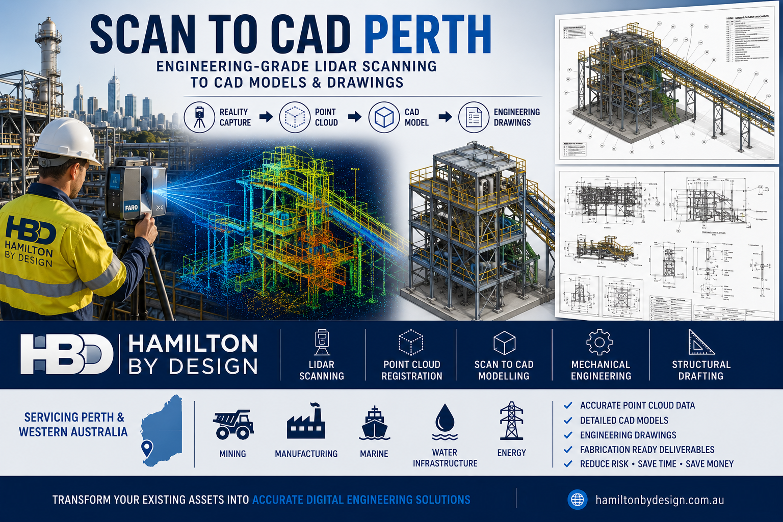
Scan to CAD Perth

Scan to CAD Perth workflow by Hamilton By Design showing engineering-grade LiDAR scanning of an industrial processing facility in Perth, Western Australia. The image illustrates the complete reality capture process from laser scanning and point cloud registration through to 3D CAD modelling, engineering drawings, mechanical engineering and structural drafting. Featured are a field engineer operating a FARO laser scanner, a coloured point cloud model, a detailed industrial plant CAD model, fabrication drawings and industries including mining, manufacturing, marine, water infrastructure and energy.

Engineering-Grade Point Cloud to CAD Services

Scan to CAD Perth

Blue 3D LiDAR scanner icon on a tripod with scanning waves

When existing facilities, equipment, structures, and process plants need to be modified, expanded, or documented, accurate information is critical. Unfortunately, many sites across Perth and Western Australia rely on outdated drawings, incomplete documentation, or site measurements that do not reflect what has actually been built.

Hamilton By Design provides professional Scan to CAD Perth services, combining engineering-grade LiDAR scanning with experienced mechanical and structural drafting to create accurate CAD models and drawings from real-world assets.

Rather than relying on tape measures or assumptions, we capture the existing environment using advanced 3D laser scanning technology and convert the resulting point cloud data into usable engineering deliverables.


What is Scan to CAD?

Scan to CAD is the process of converting physical assets into accurate digital engineering models and drawings.

The workflow typically includes:

  1. Site scanning using LiDAR technology
  2. Registration of the point cloud data
  3. Creation of CAD models
  4. Production of engineering drawings
  5. Verification against captured site conditions

The result is a highly accurate digital representation of the existing asset that can be used for engineering, maintenance, fabrication, and future upgrades.


Why Use Scan to CAD?

Many projects fail because existing site information is incorrect.

Common challenges include:

  • Missing drawings
  • Outdated drawings
  • Unrecorded modifications
  • Unknown equipment locations
  • Limited shutdown windows
  • Expensive site revisits
  • Fabrication errors
  • Installation clashes

Scan to CAD helps eliminate these issues by providing a reliable digital record of the actual site conditions.


Our Scan to CAD Workflow

1. Site Capture

Hamilton By Design uses engineering-grade LiDAR scanning equipment to capture millions of measurement points across the site.

Applications include:

  • Mining facilities
  • Processing plants
  • Structural steel installations
  • Pipework systems
  • Conveyor systems
  • Water treatment facilities
  • Manufacturing plants
  • Marine facilities

2. Point Cloud Registration

Individual scans are combined into a single registered dataset.

This process creates a coordinated point cloud representing the complete facility.

Deliverable formats can include:

  • E57
  • RCP
  • RCS
  • LAS

3. CAD Modelling

The point cloud is imported into engineering software where accurate models are developed.

Software used includes:

  • SOLIDWORKS
  • AutoCAD
  • Autodesk Inventor
  • Navisworks

Models may include:

  • Structural steel
  • Pipework
  • Mechanical equipment
  • Platforms and access systems
  • Buildings and facilities
  • Process infrastructure

4. Engineering Drawings

Once modelling is complete, the information can be converted into detailed engineering documentation.

Typical deliverables include:

  • General Arrangement Drawings
  • Fabrication Drawings
  • As-Built Drawings
  • Layout Drawings
  • Structural Steel Drawings
  • Mechanical Drawings
  • Pipework Drawings

Industries We Support in Perth

Hamilton By Design supports clients throughout Perth and Western Australia including:

Mining

  • Iron Ore
  • Gold
  • Lithium
  • Nickel
  • Mineral Processing

Manufacturing

  • Food Processing
  • Packaging Facilities
  • Industrial Production

Energy

  • Power Generation
  • Renewable Energy Facilities
  • Oil and Gas Infrastructure

Water Infrastructure

  • Water Treatment Plants
  • Pump Stations
  • Wastewater Facilities

Marine and Ports

  • Ship Repair Facilities
  • Port Infrastructure
  • Bulk Handling Equipment

Benefits of Scan to CAD

Reduce Site Visits

Capture everything during a single visit and continue working remotely.

Improve Design Accuracy

Design directly from measured site conditions.

Reduce Fabrication Risk

Accurate models help reduce costly fabrication errors.

Improve Safety

Less time measuring equipment in operational environments.

Support Future Projects

Create a digital record that can be reused for future upgrades.


Typical Scan to CAD Deliverables

Hamilton By Design can provide:

  • Point Cloud Files
  • AutoCAD Drawings
  • SOLIDWORKS Models
  • Inventor Models
  • STEP Files
  • SAT Files
  • DWG Files
  • DXF Files
  • Structural Steel Models
  • Mechanical Equipment Models
  • Pipework Models
  • Fabrication Drawings

Why Hamilton By Design?

Hamilton By Design combines reality capture technology with practical engineering experience.

Our team understands:

  • Mechanical Engineering
  • Structural Steel Design
  • Fabrication Workflows
  • Mining Infrastructure
  • Process Plants
  • Site Installation Requirements

This means we do more than simply collect scan data. We transform site information into practical engineering deliverables that support project execution.


Perth Service Area

We provide Scan to CAD services across:

  • Perth CBD
  • Kwinana
  • Henderson
  • Welshpool
  • Canning Vale
  • Malaga
  • Osborne Park
  • Rockingham
  • Fremantle
  • Bunbury
  • Geraldton
  • Kalgoorlie
  • Port Hedland
  • Karratha
  • Pilbara Region

  • 3D Laser Scanning Perth
  • LiDAR Scanning Perth
  • Mechanical Engineering Perth
  • Reverse Engineering Perth
  • Structural Drafting Perth
  • Point Cloud to CAD Modelling
  • As-Built Documentation
  • Industrial Reality Capture

Frequently Asked Questions

What is Scan to CAD?

Scan to CAD is the process of converting laser scan data into CAD models and engineering drawings.

What industries use Scan to CAD?

Mining, manufacturing, energy, water, marine, construction, and industrial facilities commonly use Scan to CAD workflows.

What file formats can be delivered?

DWG, DXF, STEP, SAT, Parasolid, E57, RCP, RCS, and PDF.

Can Scan to CAD be used for structural steel?

Yes. Existing structures can be scanned and converted into detailed structural steel models and fabrication drawings.

Can Scan to CAD be used for pipework?

Yes. Pipework systems can be modelled directly from point cloud data to support modifications and upgrades.

Do you provide services outside Perth?

Yes. Hamilton By Design supports projects throughout Western Australia and across Australia.


Our Clients


Contact Hamilton By Design

If you require accurate site information for design, fabrication, maintenance, or asset management, Hamilton By Design can help.

Our engineering-led Scan to CAD Perth services transform real-world assets into accurate digital engineering deliverables, helping projects move forward with confidence.

Hamilton By Design โ€“ Engineering, LiDAR Scanning, CAD Modelling and Drafting Services Across Perth and Western Australia.

Hamilton By Design logo displayed on a blue tilted rectangle with a grey gradient background
Name
Would you like us to arrange a phone consultation for you?
Address

Where are we in Perth

https://www.hamiltonbydesign.com.au/perth-wa
3D CAD Modelling Australia service banner for Hamilton By Design
Australian Drafting logo featuring bold white text reading "Australian Drafting" centred on a blue rounded rectangle background.
Engineering Governance title graphic featuring bold white text reading "Engineering Governance" centred on a blue rounded rectangle background.
Mechanical, Structural & Pipework Drafting service banner by Hamilton By Design featuring white text on a blue background.
Mechanical engineering services
Blue rounded button with the text โ€œSolidWorks Designโ€ in white.
Finite Element Analysis (FEA) engineering simulation button
3D LiDAR Scanning Darwin for engineering surveys, laser scanning, reality capture and point cloud modelling services
3D LiDAR Scanning Australia engineering services for laser scanning, reality capture, scan-to-CAD, Scan-to-BIM and as-built documentation across Australia
3D LiDAR scanning services on the Central Coast providing engineering-grade laser scanning, point cloud capture, scan-to-CAD modelling and industrial reality capture for infrastructure and industrial projects.
3D LiDAR Scanning Perth for engineering surveys, laser scanning, reality capture and point cloud modelling services
3D LiDAR Scanning Sydney for engineering surveys, laser scanning, reality capture and point cloud modelling services
3D LiDAR Scanning Brisbane for engineering surveys, laser scanning, reality capture and point cloud modelling services
3D LiDAR Scanning Canberra for engineering surveys, laser scanning, reality capture and point cloud modelling services
3D LiDAR Scanning Newcastle for engineering surveys, laser scanning, reality capture and point cloud modelling services
3D LiDAR Scanning Adelaide for engineering surveys, laser scanning, reality capture and point cloud modelling services
https://www.hamiltonbydesign.com.au/scan-to-bim-services-australia-lidar-point-clouds-cad-modelling

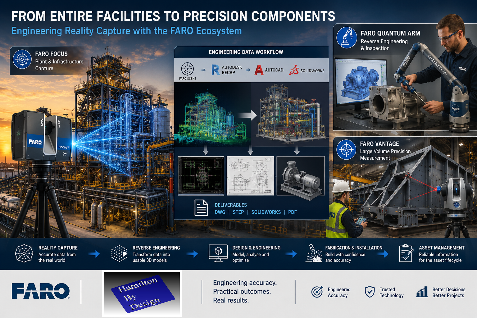
Why Hamilton By Design Has Invested in the FARO Ecosystem

Industrial engineering workflow showing FARO Focus laser scanning of a processing plant, digital Scan-to-CAD modelling, FARO Quantum Arm reverse engineering of a pump housing, and FARO Vantage laser tracker inspection of a fabricated steel structure.

At Hamilton By Design, technology investments are made with one objective in mind: delivering practical engineering outcomes for our clients.

Over the years, the reality capture market has expanded significantly, with a wide range of terrestrial scanners, mobile mapping systems, handheld scanners and metrology solutions available. While each technology has its place, we have chosen to build our reality capture and reverse engineering workflow around the FARO ecosystem because it aligns closely with the work we perform every day.

Our projects typically involve industrial facilities, mining infrastructure, manufacturing plants, process equipment, structural steel, pipework systems, shutdown planning, reverse engineering and Scan-to-CAD workflows. These applications require more than point cloud collection. They require engineering-grade information that can be transformed into practical deliverables.

A Complete Measurement Ecosystem

One of the key strengths of FARO is the breadth of its measurement portfolio.

The FARO platform spans multiple levels of measurement capability:

Large-Scale Reality Capture

The FARO Focus Series provides terrestrial laser scanning solutions capable of capturing facilities ranging from small plant rooms through to large industrial complexes and infrastructure projects.

These systems allow engineers to capture existing conditions with confidence while generating data suitable for:

  • Scan-to-CAD
  • Digital twins
  • Asset management
  • Plant modifications
  • Structural steel detailing
  • Mechanical design
  • Construction verification

Mobile Reality Capture

The FARO Orbis platform introduces mobile mapping capability while remaining connected to the wider FARO ecosystem.

For large facilities requiring rapid data acquisition, mobile scanning provides an efficient solution while maintaining compatibility with engineering workflows.

Portable Metrology

The FARO Quantum Arm extends capability beyond facility measurement into precision engineering applications.

This allows organisations to move seamlessly from measuring an entire processing plant to inspecting a single component with metrology-grade accuracy.

Applications include:

  • Reverse engineering
  • Quality control
  • Manufacturing inspection
  • Component verification
  • Precision measurement

Large Volume Precision Measurement

The FARO Vantage Laser Tracker platform provides another layer of capability for applications requiring high accuracy over large distances.

Industries including aerospace, power generation, heavy manufacturing and industrial construction rely on this technology for alignment and verification tasks where traditional surveying methods may not provide the required level of precision.

Engineering Integration Matters

For Hamilton By Design, scanning is not the final deliverable.

The point cloud is only the beginning of the engineering process.

Our clients generally require:

  • AutoCAD models
  • SolidWorks models
  • STEP files
  • Fabrication drawings
  • General arrangement drawings
  • Structural steel details
  • Mechanical engineering documentation

Because of this, we place significant value on workflows that integrate effectively with engineering software.

Our reality capture workflow commonly includes:

  • FARO Focus
  • FARO SCENE
  • Autodesk ReCap
  • AutoCAD
  • SolidWorks
  • Navisworks

This enables captured information to move efficiently from the field into engineering and manufacturing environments.

From Entire Facilities to Individual Components

One of the reasons the FARO ecosystem is particularly attractive for engineering organisations is its scalability.

A single project may involve:

  • Scanning an entire processing plant using a FARO Focus scanner.
  • Measuring a critical pump housing using a FARO Arm.
  • Verifying installation geometry using a FARO Laser Tracker.
  • Delivering engineering models through AutoCAD and SolidWorks.

All of these activities can occur within a connected measurement ecosystem.

This capability allows engineers to select the most appropriate tool for each measurement challenge rather than forcing every project into a single workflow.

Supporting Industrial Engineering Projects

Hamilton By Design operates primarily within industrial environments.

Typical projects include:

  • Mining operations
  • Mineral processing facilities
  • Manufacturing plants
  • Conveyor systems
  • Chute and hopper design
  • Pipework modifications
  • Structural steel upgrades
  • Shutdown planning
  • Reverse engineering of legacy equipment

These projects require practical engineering solutions supported by reliable measurement data.

The FARO ecosystem provides a range of tools capable of supporting these requirements, from large-scale reality capture through to precision metrology.

Engineering-Led Reality Capture

Technology alone does not guarantee project success.

The value of reality capture comes from the ability to transform measurement data into actionable engineering information.

At Hamilton By Design, our objective is not simply to collect point clouds. Our objective is to help clients make informed engineering decisions, reduce project risk, improve constructability and accelerate project delivery.

The FARO ecosystem supports this objective by providing measurement solutions that span reality capture, mobile mapping, portable metrology and large-volume precision measurement.

For engineering organisations seeking a scalable measurement platform capable of supporting projects from facility-scale scanning through to component-level verification, FARO continues to provide one of the most comprehensive portfolios available within the industry.

By combining proven measurement technology with practical engineering expertise, Hamilton By Design delivers reality capture solutions that move beyond visualisation and into real-world engineering outcomes.

Why Hamilton By Design Has Invested in the FARO Ecosystem

At Hamilton By Design, technology investments are made with one objective in mind: delivering practical engineering outcomes for our clients.

Over the years, the reality capture market has expanded significantly, with a wide range of terrestrial scanners, mobile mapping systems, handheld scanners and metrology solutions available. While each technology has its place, we have chosen to build our reality capture and reverse engineering workflow around the FARO ecosystem because it aligns closely with the work we perform every day.

Our projects typically involve industrial facilities, mining infrastructure, manufacturing plants, process equipment, structural steel, pipework systems, shutdown planning, reverse engineering and Scan-to-CAD workflows. These applications require more than point cloud collection. They require engineering-grade information that can be transformed into practical deliverables.

A Complete Measurement Ecosystem

One of the key strengths of FARO is the breadth of its measurement portfolio.

The FARO platform spans multiple levels of measurement capability:

Large-Scale Reality Capture

The FARO Focus Series provides terrestrial laser scanning solutions capable of capturing facilities ranging from small plant rooms through to large industrial complexes and infrastructure projects.

These systems allow engineers to capture existing conditions with confidence while generating data suitable for:

  • Scan-to-CAD
  • Digital twins
  • Asset management
  • Plant modifications
  • Structural steel detailing
  • Mechanical design
  • Construction verification

Mobile Reality Capture

The FARO Orbis platform introduces mobile mapping capability while remaining connected to the wider FARO ecosystem.

For large facilities requiring rapid data acquisition, mobile scanning provides an efficient solution while maintaining compatibility with engineering workflows.

Portable Metrology

The FARO Quantum Arm extends capability beyond facility measurement into precision engineering applications.

This allows organisations to move seamlessly from measuring an entire processing plant to inspecting a single component with metrology-grade accuracy.

Applications include:

  • Reverse engineering
  • Quality control
  • Manufacturing inspection
  • Component verification
  • Precision measurement

Large Volume Precision Measurement

The FARO Vantage Laser Tracker platform provides another layer of capability for applications requiring high accuracy over large distances.

Industries including aerospace, power generation, heavy manufacturing and industrial construction rely on this technology for alignment and verification tasks where traditional surveying methods may not provide the required level of precision.

Engineering Integration Matters

For Hamilton By Design, scanning is not the final deliverable.

The point cloud is only the beginning of the engineering process.

Our clients generally require:

  • AutoCAD models
  • SolidWorks models
  • STEP files
  • Fabrication drawings
  • General arrangement drawings
  • Structural steel details
  • Mechanical engineering documentation

Because of this, we place significant value on workflows that integrate effectively with engineering software.

Our reality capture workflow commonly includes:

  • FARO Focus
  • FARO SCENE
  • Autodesk ReCap
  • AutoCAD
  • SolidWorks
  • Navisworks

This enables captured information to move efficiently from the field into engineering and manufacturing environments.

From Entire Facilities to Individual Components

One of the reasons the FARO ecosystem is particularly attractive for engineering organisations is its scalability.

A single project may involve:

  • Scanning an entire processing plant using a FARO Focus scanner.
  • Measuring a critical pump housing using a FARO Arm.
  • Verifying installation geometry using a FARO Laser Tracker.
  • Delivering engineering models through AutoCAD and SolidWorks.

All of these activities can occur within a connected measurement ecosystem.

This capability allows engineers to select the most appropriate tool for each measurement challenge rather than forcing every project into a single workflow.

Supporting Industrial Engineering Projects

Hamilton By Design operates primarily within industrial environments.

Typical projects include:

  • Mining operations
  • Mineral processing facilities
  • Manufacturing plants
  • Conveyor systems
  • Chute and hopper design
  • Pipework modifications
  • Structural steel upgrades
  • Shutdown planning
  • Reverse engineering of legacy equipment

These projects require practical engineering solutions supported by reliable measurement data.

The FARO ecosystem provides a range of tools capable of supporting these requirements, from large-scale reality capture through to precision metrology.

Engineering-Led Reality Capture

Technology alone does not guarantee project success.

The value of reality capture comes from the ability to transform measurement data into actionable engineering information.

At Hamilton By Design, our objective is not simply to collect point clouds. Our objective is to help clients make informed engineering decisions, reduce project risk, improve constructability and accelerate project delivery.

The FARO ecosystem supports this objective by providing measurement solutions that span reality capture, mobile mapping, portable metrology and large-volume precision measurement.

For engineering organisations seeking a scalable measurement platform capable of supporting projects from facility-scale scanning through to component-level verification, FARO continues to provide one of the most comprehensive portfolios available within the industry.

By combining proven measurement technology with practical engineering expertise, Hamilton By Design delivers reality capture solutions that move beyond visualisation and into real-world engineering outcomes.

3D LiDAR scanning and 3D modelling services button
Mechanical engineering services
Building and construction services button
Hamilton By Design logo displayed on a blue tilted rectangle with a grey gradient background

Would you like to know more ?

Contact Us – Talk to Us

Name
Would you like us to arrange a phone consultation for you?
Address

Our Clients

3D LiDAR scanning and 3D modelling service button โ€” laser scanner capturing a point cloud for engineering and CAD modelling
Mechanical engineering services

3D Scanning Sydney banner promoting engineering-grade 3D laser scanning, LiDAR scanning, and reality capture services by Hamilton By Design.
Mechanical Engineering Sydney banner with white text on a blue background representing Hamilton By Design's mechanical engineering services in Sydney.
Mechanical Drafting and 3D Modelling Sydney banner highlighting Hamilton By Design's CAD drafting, 3D modelling, and engineering design services in Sydney.
Blue banner graphic displaying the text "Point Cloud to CAD - Australia" in large white lettering, representing point cloud processing, scan-to-CAD conversion and digital engineering services across Australia.
Blue banner graphic displaying the text "Scan to CAD Sydney" in large white lettering, representing engineering-led point cloud to CAD conversion, LiDAR scanning and digital engineering services in Sydney.
Blue banner graphic displaying the text "Reality Capture Sydney - CBD" in large white lettering, representing engineering-led reality capture, LiDAR scanning and digital engineering services within Sydney CBD commercial buildings and infrastructure.

Scan-to-CAD vs Traditional Design Workflows | Which Approach Delivers Better Engineering Outcomes?

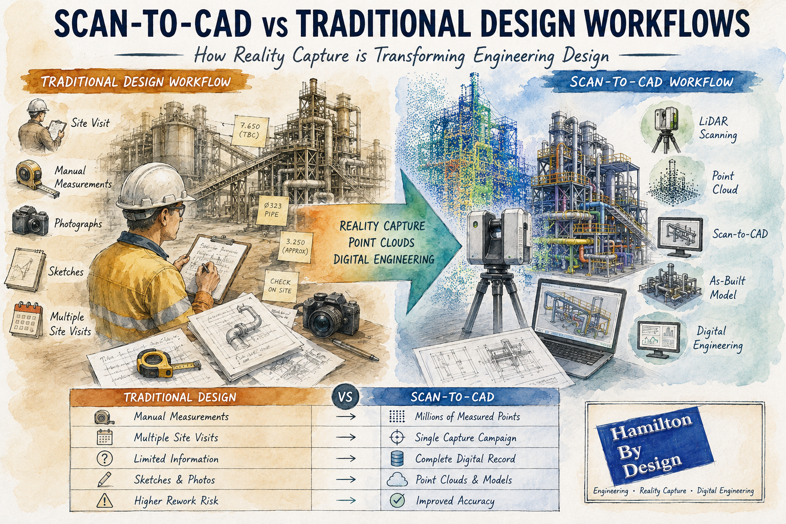
Scan-to-CAD vs traditional design workflows infographic showing LiDAR scanning, point cloud modelling, reality capture and digital engineering for industrial plant design and as-built documentation.

Scan-to-CAD vs Traditional Design Workflows: How Reality Capture is Transforming Engineering Design

For decades, engineering and drafting companies have relied on traditional design workflows to create new assets, modify existing facilities and develop construction documentation. These methods typically involve site visits, manual measurements, photographs, sketches and extensive assumptions about existing conditions.

While traditional design processes have successfully delivered countless projects, modern reality capture technologies are changing how engineering data is collected and utilised.

The introduction of terrestrial LiDAR scanning, engineering-grade reality capture and point cloud modelling has given design companies access to highly accurate representations of existing facilities. Rather than starting with assumptions and limited measurements, engineers can now begin with a digital copy of reality.

This approach is commonly known as Scan-to-CAD.

At Hamilton By Design, we have seen first-hand how Scan-to-CAD workflows can improve project accuracy, reduce site visits and provide better information for engineering decision-making. However, traditional design methods still have an important role to play.

The key is understanding where each approach provides the greatest value.


What is a Traditional Design Workflow?

Traditional design workflows generally begin with a site inspection and manual data collection process.

An engineer, designer or draftsperson visits the facility and records information such as:

  • Dimensions
  • Levels
  • Equipment locations
  • Structural arrangements
  • Pipe routing
  • Building layouts
  • Photographs
  • Sketches

The collected information is then used to develop drawings and 3D models.

A typical workflow may include:

  1. Site visit
  2. Manual measurements
  3. Photographic survey
  4. Sketch preparation
  5. CAD model creation
  6. Design development
  7. Drawing production
  8. Construction issue

This process has been the backbone of engineering design for many years.


Challenges with Traditional Design Methods

Although effective, traditional workflows present several challenges.

Limited Data Collection

No matter how experienced the survey team is, it is impossible to measure everything.

Often only dimensions considered important at the time are collected.

If additional information is required later, another site visit may be necessary.

Human Error

Manual measurements introduce opportunities for error.

Common issues include:

  • Incorrect dimensions
  • Missed measurements
  • Recording errors
  • Inconsistent datum references

These errors can propagate throughout the project.

Access Restrictions

Industrial facilities often contain:

  • Confined spaces
  • Elevated structures
  • Operational equipment
  • Hazardous environments

Obtaining measurements in these areas can be difficult and expensive.

Multiple Site Visits

Many projects require repeated visits to verify dimensions and resolve discrepancies.

This increases:

  • Project costs
  • Travel expenses
  • Programme duration

What is Scan-to-CAD?

Scan-to-CAD is the process of using reality capture technologies to create engineering drawings and models.

The workflow begins with a terrestrial LiDAR scan of the facility.

Millions or billions of measured points are captured to create a highly detailed point cloud.

The point cloud then becomes the foundation for:

  • CAD models
  • BIM models
  • General arrangement drawings
  • Structural models
  • Pipework layouts
  • Reverse engineering projects
  • Asset documentation

Rather than manually measuring selected features, Scan-to-CAD captures the entire environment.


How Scan-to-CAD Works

Step 1 โ€“ Reality Capture

A LiDAR scanner records the existing facility.

This may include:

  • Buildings
  • Process plants
  • Pipework
  • Conveyors
  • Tanks
  • Structural steel
  • Mechanical equipment

Step 2 โ€“ Point Cloud Registration

Individual scans are combined into a unified coordinate system.

The result is a complete digital representation of the site.

Step 3 โ€“ Engineering Review

Engineers review the point cloud and determine project requirements.

Step 4 โ€“ CAD Modelling

Relevant assets are modelled from the point cloud.

Outputs may include:

  • 2D drawings
  • 3D CAD models
  • BIM models
  • Fabrication drawings
  • Construction documentation

Step 5 โ€“ Design Development

The design team develops modifications directly against existing conditions.


Comparing Scan-to-CAD and Traditional Design Workflows

Accuracy

Traditional Workflow

Accuracy depends on:

  • Measurement methods
  • Survey coverage
  • Site conditions
  • Human interpretation

Typically, only selected dimensions are recorded.

Scan-to-CAD

Millions of measured points create a detailed digital representation.

Engineering-grade terrestrial LiDAR scanning can provide highly accurate spatial information across entire facilities.

Winner: Scan-to-CAD


Site Time

Traditional Workflow

Complex facilities may require several site visits.

Scan-to-CAD

Most information is captured during a single scanning campaign.

Winner: Scan-to-CAD


Data Availability

Traditional Workflow

Only measured dimensions are available.

Scan-to-CAD

The entire captured environment remains available for future reference.

Winner: Scan-to-CAD


Upfront Cost

Traditional Workflow

Lower initial survey costs.

Scan-to-CAD

Requires specialised scanning equipment and processing.

Winner: Traditional Workflow


Long-Term Value

Traditional Workflow

Information is often project-specific.

Scan-to-CAD

Point clouds become long-term digital assets.

Winner: Scan-to-CAD


Why Design Companies Are Adopting Scan-to-CAD

Increasingly, engineering consultancies and drafting companies are integrating reality capture into their workflows.

Benefits include:

Reduced Rework

Designs can be developed against actual site conditions.

Improved Clash Detection

Existing assets can be modelled accurately.

Better Stakeholder Communication

Point clouds and digital models improve project visualisation.

Enhanced Project Planning

Engineers can assess access and constructability earlier.

Faster Design Iterations

Additional measurements are often available without returning to site.


Applications Across Industries

Mining

Mining facilities contain extensive:

  • Conveyors
  • Chutes
  • Crushers
  • Tanks
  • Pipework

Scan-to-CAD can significantly improve brownfield modification projects.

Manufacturing

Production facilities frequently evolve over time.

Reality capture provides accurate documentation of current conditions.

Water and Wastewater

Pump stations and treatment plants often contain complex mechanical layouts.

Scan-to-CAD improves upgrade planning and documentation.

Commercial Buildings

Architects and engineers can generate accurate as-built documentation.

Energy

Power stations and industrial utilities benefit from detailed digital asset records.


When Traditional Workflows Still Make Sense

Despite the advantages of reality capture, traditional methods remain valuable.

Examples include:

Concept Design

Early-stage feasibility studies may not require detailed site data.

Greenfield Projects

When designing on vacant land, no existing assets exist to scan.

Small Modifications

Minor changes may not justify scanning costs.

Budget-Constrained Projects

Some projects require a lower-cost approach.

The most successful engineering organisations understand that both approaches have their place.


The Rise of AI-Assisted Scan-to-CAD

Artificial Intelligence is introducing new capabilities into reality capture workflows.

Emerging technologies can:

  • Identify pipework
  • Classify equipment
  • Recognise structural steel
  • Generate preliminary BIM models
  • Accelerate modelling workflows

Although engineering verification remains essential, AI-assisted modelling is expected to become increasingly common.


Digital Twins and Future Design Workflows

The future of engineering design is likely to combine:

  • Reality capture
  • Scan-to-CAD
  • Scan-to-BIM
  • Digital twins
  • Artificial intelligence
  • Cloud collaboration

Rather than creating drawings from limited measurements, engineering teams will increasingly work from comprehensive digital representations of existing assets.

This shift has the potential to improve project quality, reduce risk and accelerate project delivery.


How Hamilton By Design Supports Scan-to-CAD Projects

Hamilton By Design provides engineering-led reality capture and Scan-to-CAD services throughout Australia.

Our capabilities include:

  • Terrestrial LiDAR scanning
  • Engineering-grade reality capture
  • Point cloud registration
  • Scan-to-CAD
  • Scan-to-BIM
  • Reverse engineering
  • Mechanical design
  • Structural drafting
  • Asset documentation
  • Digital engineering support

We work across:

  • Mining
  • Manufacturing
  • Infrastructure
  • Energy
  • Commercial buildings
  • Water and wastewater

Our approach combines practical engineering experience with modern reality capture technology to deliver accurate and usable engineering information.


Hamilton By Design logo displayed on a blue tilted rectangle with a grey gradient background

Traditional design workflows have served the engineering industry well for decades and continue to play an important role in many projects.

However, the emergence of Scan-to-CAD workflows has fundamentally changed how existing facilities can be documented and modelled.

By capturing measured reality rather than relying solely on manual measurements, engineering teams gain access to more complete information, improved accuracy and greater flexibility throughout the design process.

For brownfield projects, industrial facilities and complex infrastructure, Scan-to-CAD is increasingly becoming the preferred method for developing accurate engineering deliverables.

Rather than replacing traditional design workflows, reality capture enhances them, providing engineers and designers with a richer foundation from which to make informed decisions.


Frequently Asked Questions (FAQ)

What is Scan-to-CAD?

Scan-to-CAD is the process of converting LiDAR scan data or point clouds into CAD drawings and 3D models. It allows engineers to develop designs using accurate representations of existing assets.

How accurate is Scan-to-CAD?

Accuracy depends on the scanning equipment and workflow used. Engineering-grade terrestrial LiDAR scanning can provide highly accurate spatial information suitable for engineering and drafting applications.

What industries benefit most from Scan-to-CAD?

Mining, manufacturing, infrastructure, energy, commercial buildings, water treatment facilities and industrial processing plants all benefit from Scan-to-CAD workflows.

Is Scan-to-CAD better than traditional surveying?

Both approaches have value. Scan-to-CAD generally provides more comprehensive site information, while traditional surveying may be appropriate for smaller or less complex projects.

Can point clouds be used directly in CAD software?

Yes. Many CAD platforms can reference point cloud data directly, allowing engineers to model against real-world measurements.

What is the difference between Scan-to-CAD and Scan-to-BIM?

Scan-to-CAD focuses on creating engineering drawings and CAD models, while Scan-to-BIM creates Building Information Models containing both geometry and asset information.

Does Scan-to-CAD reduce site visits?

In many cases, yes. Capturing comprehensive scan data can significantly reduce the need for repeat measurement visits.

Can AI automatically create CAD models from point clouds?

AI-assisted modelling tools are becoming increasingly capable, but engineering review and verification remain essential for accurate project outcomes.

What deliverables can be produced from a Scan-to-CAD project?

Deliverables may include point clouds, CAD models, BIM models, fabrication drawings, as-built drawings, general arrangement drawings and digital twin models.

Why choose Hamilton By Design for Scan-to-CAD projects?

Hamilton By Design combines engineering-led reality capture, practical industry experience and advanced digital engineering workflows to deliver accurate and usable engineering information for industrial and infrastructure projects throughout Australia.


Mechanical Engineering | Structural Engineering


3D LiDAR Scanning Darwin for engineering surveys, laser scanning, reality capture and point cloud modelling services
3D LiDAR Scanning Australia engineering services for laser scanning, reality capture, scan-to-CAD, Scan-to-BIM and as-built documentation across Australia
3D LiDAR scanning services on the Central Coast providing engineering-grade laser scanning, point cloud capture, scan-to-CAD modelling and industrial reality capture for infrastructure and industrial projects.
3D LiDAR Scanning Perth for engineering surveys, laser scanning, reality capture and point cloud modelling services
3D LiDAR Scanning Sydney for engineering surveys, laser scanning, reality capture and point cloud modelling services
3D LiDAR Scanning Brisbane for engineering surveys, laser scanning, reality capture and point cloud modelling services
3D LiDAR Scanning Canberra for engineering surveys, laser scanning, reality capture and point cloud modelling services
3D LiDAR Scanning Newcastle for engineering surveys, laser scanning, reality capture and point cloud modelling services
3D LiDAR Scanning Adelaide for engineering surveys, laser scanning, reality capture and point cloud modelling services

SolidWorks Point Cloud to CAD Workflow | From LiDAR Scans to Detailed Engineering Drawings

SolidWorks Workflow for Converting Point Cloud Data into Detailed Engineering Drawings

From Reality Capture to Fabrication Documentation

The rapid adoption of terrestrial LiDAR scanning and engineering-grade reality capture technologies has fundamentally changed the way engineering projects are executed. For decades, engineers, designers and BIM specialists have relied on traditional workflows that begin with conceptual layouts, survey control, architectural envelopes or predefined design models. Today, however, many industrial projects start with something entirely different: a point cloud.

Instead of beginning with assumptions about what exists, engineering teams can now begin with measured reality.

This shift has significant implications for how projects are planned, modelled and documented. It also raises an important discussion regarding the role of Building Information Modelling (BIM), top-down modelling techniques and traditional design workflows when accurate point cloud information is available from the outset.

While BIM remains a powerful methodology, reality capture introduces a different way of thinking that is particularly valuable for brownfield, industrial, mining, manufacturing and infrastructure projects.

The reality is that neither approach is universally better than the other.

As with most engineering decisions, it is often a case of horses for courses.


The Rise of Engineering-Grade Reality Capture

Modern terrestrial LiDAR scanners can capture millions of points every second, producing highly accurate three-dimensional representations of existing facilities.

These systems are now routinely used throughout:

  • Mining operations
  • Mineral processing plants
  • Smelters
  • Power stations
  • Water treatment facilities
  • Manufacturing plants
  • Commercial buildings
  • Hospitals
  • Transport infrastructure
  • Refineries

Unlike traditional survey methods that capture selected points, LiDAR scanning captures entire environments.

The resulting point cloud becomes a digital record of reality.

Engineers can then revisit the site virtually, long after the field work has been completed.

This offers significant advantages including:

  • Reduced site visits
  • Improved safety
  • Faster design development
  • Better clash detection
  • Enhanced stakeholder collaboration
  • Improved asset documentation
  • Accurate retrofit design

For industrial facilities where access may be restricted, hazardous or costly, point cloud data often becomes one of the most valuable project assets available.


Understanding Point Clouds

A point cloud is a collection of millions or billions of measured XYZ coordinates.

Each point represents a location in space.

When combined, these points create a highly detailed representation of physical objects including:

  • Structural steel
  • Pipework
  • Equipment
  • Conveyors
  • Tanks
  • Buildings
  • Mechanical components
  • Electrical services
  • Access systems

Modern scanners may also capture colour information, intensity data and imagery, creating a realistic digital twin of the physical environment.

Unlike traditional CAD models, point clouds contain measured information rather than designed information.

This distinction is important.

A CAD model represents what was intended.

A point cloud represents what actually exists.

For brownfield engineering projects this difference can be substantial.


Why Traditional BIM Workflows Can Struggle

Building Information Modelling originated primarily within the architectural and construction sectors.

The traditional BIM process generally follows a sequence such as:

Concept Design โ†’ Schematic Design โ†’ Detailed Design โ†’ Construction โ†’ Asset Management

The model evolves as the project progresses.

In many BIM workflows the process begins with an architectural envelope or predefined design geometry.

Walls, floors, columns and services are created within a structured modelling environment.

This approach works exceptionally well for:

  • New buildings
  • Greenfield developments
  • Commercial construction
  • Architectural projects
  • Civil infrastructure projects

However, industrial facilities rarely fit neatly into these categories.

A mining plant built over 40 years may contain:

  • Multiple undocumented modifications
  • Legacy equipment
  • Inaccurate drawings
  • Informal field changes
  • Missing records
  • Deformed structures
  • Equipment relocations

In these situations the design model is often less accurate than the physical asset itself.

This creates a challenge.

Traditional BIM workflows frequently assume the model is the primary source of truth.

Reality capture reverses that assumption.

The point cloud becomes the source of truth.

The model simply becomes a representation of measured reality.


Reality-First Engineering

A reality-first workflow begins with data acquisition rather than design assumptions.

The process typically follows:

  1. Site Scanning
  2. Point Cloud Registration
  3. Quality Assurance
  4. Point Cloud Optimisation
  5. Model Development
  6. Engineering Analysis
  7. Drawing Production
  8. Construction Documentation

Instead of asking:

“What should this facility look like?”

The workflow asks:

“What does this facility actually look like?”

This subtle change can significantly improve project outcomes.


SolidWorks and Point Cloud Modelling

SolidWorks has evolved into a powerful platform for working with reality capture data.

While originally developed as a mechanical design system, modern versions provide excellent capabilities for integrating scan data into engineering workflows.

Point clouds can be imported through various formats including:

  • E57
  • LAS
  • XYZ
  • PLY
  • STL
  • OBJ
  • Mesh formats

Depending on project requirements, the workflow may involve:

  • Direct point cloud reference
  • Mesh generation
  • Surface modelling
  • Parametric feature creation
  • Reverse engineering
  • Assembly development

The chosen approach depends on the intended deliverable.


The Importance of Top-Down Modelling

Top-down modelling becomes particularly valuable when working from point cloud data.

Traditional bottom-up modelling involves creating individual components separately before assembling them.

Top-down modelling reverses this process.

The assembly becomes the master model.

Individual components are then developed within the context of the larger system.

For industrial facilities this approach offers significant advantages.


Why Top-Down Modelling Works Well with Point Clouds

A point cloud already contains contextual information.

Pipework exists relative to equipment.

Equipment exists relative to structures.

Structures exist relative to buildings.

Everything already has a defined relationship.

Top-down modelling allows engineers to preserve these relationships.

For example:

A conveyor transfer chute may be modelled directly within the context of:

  • Existing conveyor structure
  • Existing walkways
  • Existing pipework
  • Existing electrical services
  • Existing maintenance access

The design develops within the reality captured environment.

This significantly reduces the risk of clashes.


Skeleton Models and Layout Control

One of the most effective top-down approaches involves the use of skeleton models.

A skeleton model contains:

  • Key reference geometry
  • Design planes
  • Centre lines
  • Control sketches
  • Interface locations

When working from point clouds, the skeleton model can be created directly from measured geometry.

This establishes a reliable framework for the remainder of the design.

Individual components then inherit relationships from the skeleton model.

Benefits include:

  • Improved consistency
  • Faster design changes
  • Better design intent control
  • Reduced assembly errors

Scan-to-CAD Workflow

A typical Scan-to-CAD workflow within SolidWorks may follow the following sequence.

Step 1 โ€“ Site Capture

Engineering-grade LiDAR scanning is completed on site.

Data is collected from multiple scanner positions.

The objective is to capture sufficient coverage while maintaining registration quality.


Step 2 โ€“ Registration

Individual scans are registered into a unified coordinate system.

This produces a complete point cloud.

Quality control is performed to verify registration accuracy.

Typical industrial projects may achieve overall accuracies within several millimetres.


Step 3 โ€“ Point Cloud Cleaning

Noise is removed.

Unwanted objects may be filtered.

Temporary equipment can be excluded.

The objective is to create a usable engineering dataset.


Step 4 โ€“ Import into Modelling Environment

The point cloud is imported into the modelling platform.

At this stage the cloud becomes a digital reference.

The cloud itself is generally not modified.

Instead, engineering geometry is created around it.


Step 5 โ€“ Create Reference Geometry

Reference planes, axes and coordinate systems are established.

These form the foundation of the modelling process.

Top-down methodologies become particularly valuable at this stage.


Step 6 โ€“ Build Parametric Models

Engineering components are modelled using parametric features.

Examples include:

  • Structural steel
  • Tanks
  • Pipework
  • Chutes
  • Platforms
  • Conveyors
  • Ductwork

The resulting model remains editable and fully configurable.


Step 7 โ€“ Validation

The model is compared against the point cloud.

Engineers verify fit, alignment and geometry.

Potential clashes are identified early.


Step 8 โ€“ Drawing Production

Detailed drawings are generated directly from the validated model.

Deliverables may include:

  • General arrangements
  • Fabrication drawings
  • Assembly drawings
  • Pipe spool drawings
  • Structural steel details
  • Installation drawings
  • Bill of materials

Reverse Engineering Using Point Clouds

Reverse engineering is one of the most powerful applications of reality capture.

Many industrial facilities contain components with:

  • Missing drawings
  • Obsolete equipment
  • Unknown suppliers
  • Legacy modifications

Point clouds provide a practical starting point.

Engineers can recreate:

  • Mechanical components
  • Structural systems
  • Pipework networks
  • Fabricated assemblies

The resulting CAD models become valuable engineering assets.


Parametric Models versus Mesh Models

A common mistake is assuming that a mesh model is equivalent to a CAD model.

It is not.

A mesh represents geometry.

A parametric model represents engineering intent.

This distinction is critical.

A parametric SolidWorks model allows:

  • Dimension changes
  • Configuration control
  • Design modifications
  • Manufacturing documentation
  • Finite element analysis

For most engineering applications, converting point clouds into intelligent parametric models provides significantly greater value than simply generating meshes.


Producing Detailed Engineering Drawings

Once a validated model exists, drawing production becomes straightforward.

SolidWorks can automatically generate:

  • Orthographic views
  • Sections
  • Detail views
  • Exploded views
  • Bills of materials
  • Weldment cut lists

This dramatically reduces drafting effort.

Because the drawings originate from the model, consistency is maintained throughout the project.


Brownfield Projects Benefit Most

The reality-first workflow delivers the greatest value in brownfield environments.

These include:

  • Operating mines
  • Smelters
  • Refineries
  • Processing plants
  • Manufacturing facilities
  • Water treatment plants

In these environments accurate existing-condition information is often more valuable than historic drawings.

A point cloud provides a measurable record of the asset as it exists today.


BIM versus Point Cloud Driven Engineering

This discussion is sometimes framed as:

“BIM versus Reality Capture.”

In practice this is the wrong question.

Reality capture and BIM should not be viewed as competing technologies.

They solve different problems.

BIM provides:

  • Information management
  • Design coordination
  • Asset lifecycle management
  • Construction planning
  • Facility management integration

Reality capture provides:

  • Existing-condition verification
  • Accurate geometry
  • Retrofit design support
  • Asset documentation
  • Digital twin creation

The most successful projects often combine both approaches.


A Modern Hybrid Workflow

Increasingly, engineering organisations are adopting a hybrid workflow.

The process becomes:

Reality Capture โ†’ Engineering Model โ†’ BIM Integration

Rather than creating BIM models based on assumptions, the BIM environment is populated using measured reality.

This approach improves confidence throughout the project lifecycle.

The BIM system benefits from more accurate geometry.

The engineering team benefits from reliable site information.

The asset owner benefits from better data quality.

Everybody wins.


The Future of Digital Engineering

The future of engineering is likely to become increasingly reality driven.

Advancements in:

  • LiDAR technology
  • Mobile scanning
  • Drone scanning
  • Artificial Intelligence
  • Automated feature extraction
  • Digital twins

will continue to accelerate the adoption of reality capture workflows.

However, traditional engineering principles remain essential.

Engineers still need to understand:

  • Design intent
  • Structural behaviour
  • Manufacturing processes
  • Construction methods
  • Asset management requirements

Technology provides information.

Engineering provides understanding.


SolidWorks provides an exceptionally capable platform for converting point cloud data into detailed engineering models and fabrication drawings. When combined with top-down modelling methodologies, point clouds become far more than visual references; they become the foundation of the engineering workflow.

Traditional BIM methodologies remain highly effective for greenfield projects and building-centric developments where the design model drives project delivery. However, in brownfield industrial environments the reality often differs from the original design documentation. In these situations, a point cloud frequently becomes the most accurate representation of the asset available.

Rather than viewing BIM and reality capture as competing philosophies, modern engineering teams should recognise the strengths of each approach. BIM excels at information management, coordination and lifecycle planning, while point cloud-driven workflows excel at capturing existing conditions and enabling accurate retrofit design.

Ultimately, the most effective solution is often a hybrid approach that combines the strengths of both. By starting with measured reality, developing intelligent parametric models in SolidWorks and integrating those models into broader BIM environments where appropriate, engineers can reduce risk, improve accuracy and deliver higher quality outcomes.

As digital engineering continues to evolve, the question is no longer whether point clouds should be used. The question is how effectively organisations can transform reality capture data into actionable engineering information that supports design, construction, operation and long-term asset management.

Hamilton By Design logo displayed on a blue tilted rectangle with a grey gradient background

Contact Us – Talk to Us

Name
Would you like us to arrange a phone consultation for you?
Address

Our Clients:

3D CAD Modelling Australia service banner for Hamilton By Design
3D LiDAR scanning and 3D modelling service button โ€” laser scanner capturing a point cloud for engineering and CAD modelling
Mechanical engineering services
3D CAD Modelling Australia service banner for Hamilton By Design
Mechanical, Structural & Pipework Drafting service banner by Hamilton By Design featuring white text on a blue background.
Australian Drafting logo featuring bold white text reading "Australian Drafting" centred on a blue rounded rectangle background.
Blue banner graphic displaying the text "Point Cloud to CAD - Australia" in large white lettering, representing point cloud processing, scan-to-CAD conversion and digital engineering services across Australia.
CHPP Engineering title graphic featuring bold white text reading "CHPP Engineering" centred on a blue rounded rectangle background.
Engineering Governance title graphic featuring bold white text reading "Engineering Governance" centred on a blue rounded rectangle background.
Mechanical engineering services
Australian Drafting logo featuring bold white text reading "Australian Drafting" centred on a blue rounded rectangle background.
3D LiDAR Scanning Hunter & Newcastle banner with white text on a blue background promoting engineering-grade laser scanning services for industrial, mining and infrastructure projects across the Hunter Valley and Newcastle region.
Mechanical Engineering Hunter & Newcastle banner promoting mechanical engineering services for mining, industrial plants, power generation, manufacturing and heavy industry throughout the Hunter Valley and Newcastle region.
Structural Drafting Hunter & Newcastle banner promoting structural drafting services for mining, industrial plants, power generation, manufacturing and infrastructure projects across the Hunter Valley and Newcastle region.
Mechanical Engineering Perth WA banner for Hamilton By Design featuring white text on a blue background.
3D Laser Scanning Perth WA banner for Hamilton By Design with white text on a blue background.
SolidWorks Perth WA banner for Hamilton By Design featuring white text on a blue background.
Fabrication and product design services
Finite Element Analysis (FEA) engineering simulation button
3D LiDAR scanning and 3D modelling service button โ€” laser scanner capturing a point cloud for engineering and CAD modelling
Blue rounded button with the text โ€œSolidWorks Designโ€ in white.
Mechanical drafting services button
Structural drafting services button

Mechanical Engineering | Structural Engineering


3D LiDAR Scanning Darwin for engineering surveys, laser scanning, reality capture and point cloud modelling services
3D LiDAR Scanning Australia engineering services for laser scanning, reality capture, scan-to-CAD, Scan-to-BIM and as-built documentation across Australia
3D LiDAR scanning services on the Central Coast providing engineering-grade laser scanning, point cloud capture, scan-to-CAD modelling and industrial reality capture for infrastructure and industrial projects.