Terrestrial LiDAR Scanner | Engineering-Grade 3D Laser Scanning

Terrestrial LiDAR scanner capturing industrial plant

What is a Terrestrial LiDAR Scanner?

A terrestrial LiDAR scanner is a ground-based 3D laser scanning system used to capture highly accurate measurements of real-world environments and convert them into detailed digital models known as point clouds.

At Hamilton By Design, we use engineering-grade terrestrial LiDAR scanning to support design, drafting, and construction across industrial, mining, and infrastructure projects.



3D LiDAR scanning and 3D modelling service button โ€” laser scanner capturing a point cloud for engineering and CAD modelling
Mechanical engineering services

How a Terrestrial LiDAR Scanner Works

A terrestrial LiDAR scanner measures distance using laser technology:

  • A laser beam is emitted from the scanner
  • The beam reflects off surfaces such as steel, concrete, or pipework
  • The scanner records the return signal
  • Distance is calculated using time-of-flight or phase shift
  • Millions of measurements are captured per second

The result is a dense and accurate 3D point cloud representing the scanned environment.


What is a Point Cloud?

A point cloud is a digital dataset made up of millions (or billions) of points.

Each point contains:

  • X, Y, Z coordinates
  • Spatial position in 3D space
  • Optional colour information (RGB)

This creates a true-to-life digital representation of physical assets, forming the foundation for CAD modelling and engineering design.


Why Use a Terrestrial LiDAR Scanner?

Accuracy

Terrestrial LiDAR scanners provide millimetre-level accuracy, making them suitable for engineering and fabrication.

Speed

Large and complex environments can be captured quickly compared to traditional survey methods.

Safety

Data can be captured without direct access to hazardous or difficult-to-reach areas.

Reduced Rework

Designs are based on real-world data, reducing clashes and site modifications.


3D CAD Modelling Australia service banner for Hamilton By Design

Engineering Applications

Terrestrial LiDAR scanning is widely used across:

  • Industrial plant upgrades
  • Mining and processing facilities
  • Structural and mechanical design
  • Brownfield engineering projects
  • As-built verification
  • Reverse engineering

For projects requiring integration with your team, this capability can also be delivered through our engineering secondment services:
https://www.hamiltonbydesign.com.au/home/secondment-services/


Engineering-Led LiDAR Scanning

Not all LiDAR scanning is equal.

At Hamilton By Design, scanning is performed with an engineering-first approach, ensuring the data is suitable for downstream use in CAD and design.

Key considerations include:

  • Line-of-sight limitations
  • Scan density and coverage
  • Registration accuracy
  • Data structure and usability

This ensures the output is not just a visual model, but a usable engineering dataset.


From Scan to CAD

Our workflow converts LiDAR data into practical deliverables:

Scan โ†’ Register โ†’ Model โ†’ Detail โ†’ Deliver

This includes:

  • Point cloud registration (.E57, .RCP, .LAS)
  • 3D CAD modelling (SolidWorks and other platforms)
  • 2D drawings and fabrication-ready documentation

Terrestrial vs Other Scanning Methods

  • Terrestrial LiDAR: High accuracy, long range, ideal for engineering
  • Handheld scanners: Faster but lower accuracy, suited to small objects
  • Photogrammetry: Visual models, not typically engineering-grade

For industrial and brownfield environments, terrestrial LiDAR remains the preferred method.


Terrestrial LiDAR scanner capturing industrial plant with Sydney Harbour Bridge in background

In-House & Secondment Delivery

We provide flexible delivery models to suit your project:

  • In-house scanning and modelling (fully managed)
  • Secondment services (embedded within your team)

Learn more about our secondment capability:
https://www.hamiltonbydesign.com.au/home/secondment-services/


Why Choose Hamilton By Design

  • Engineering-led LiDAR scanning
  • Integration with CAD modelling and drafting
  • Strong experience in industrial and mining environments
  • Brownfield project expertise
  • Practical, buildable outputs

Hamilton By Design logo displayed on a blue tilted rectangle with a grey gradient background

Get Started with Terrestrial LiDAR Scanning

If you require accurate, engineering-grade 3D data for your project, a terrestrial LiDAR scanner provides the foundation for reliable design and execution.

Hamilton By Design delivers scanning, modelling, and engineering support across Sydney and Australia.
Talk to Us – Contact Us

Name
Would you like us to arrange a phone consultation for you?
Address

Mechanical Engineering | Structural Engineering


Wearable 3D Scanners vs Engineering-Grade LiDAR

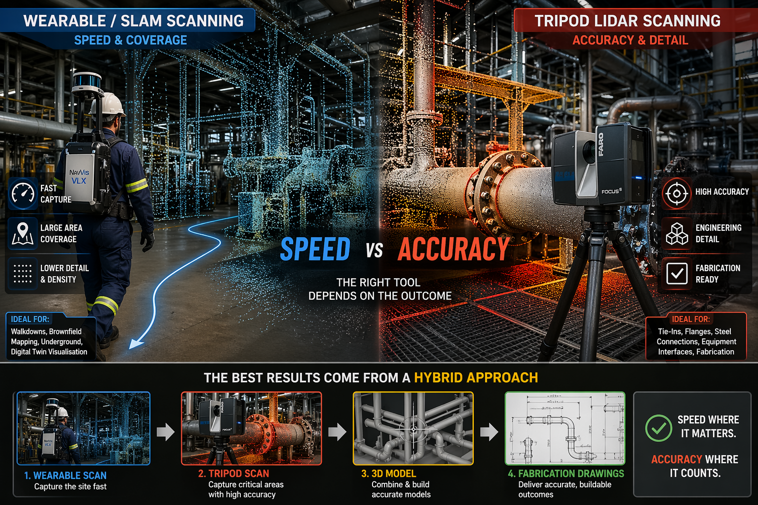
Wearable SLAM lidar scanner compared with tripod laser scanner in an industrial plant showing speed versus accuracy in point cloud data

Wearable 3D Scanners vs LiDAR | Engineering Accuracy Explained

Why Speed Doesnโ€™t Always Mean Accuracy in Industrial Scanning

Blue 3D LiDAR scanner icon on a tripod with scanning waves

Wearable 3D scanning systems โ€” often referred to as backpack or body-mounted LiDAR scanners โ€” are becoming increasingly common across mining, construction, and industrial environments.

These systems allow an operator to walk through a site and capture data in real time, significantly reducing time spent in the field.

However, while speed has improved, an important question remains:

Are wearable scanners suitable for engineering and fabrication work?

At Hamilton By Design, we take an engineering-led approach to scanning. The answer is not as simple as many vendors suggest.


3D LiDAR scanning and 3D modelling service button โ€” laser scanner capturing a point cloud for engineering and CAD modelling
Mechanical engineering services

What Are Wearable 3D Scanners?

Wearable scanners, also known as SLAM LiDAR systems, are designed to be worn while walking through a site.

They typically use a combination of:

  • LiDAR sensors
  • Cameras
  • Inertial Measurement Units (IMU)
  • SLAM (Simultaneous Localisation and Mapping) algorithms

This allows the system to generate a continuous 3D point cloud without the need for tripod setups or survey targets.

In simple terms, the operator becomes the scanner.


The Key Advantage: Speed

The main advantage of wearable systems is speed.

They allow for:

  • Rapid site capture
  • Minimal setup time
  • Scanning of complex or confined environments
  • Efficient coverage of large areas

For walkdowns, site familiarisation, and early-stage layouts, wearable scanning is highly effective.


The Trade-Off: Accuracy and Detail

While wearable systems offer speed, they come with trade-offs.

Wearable SLAM scanners typically produce:

  • Lower point density
  • Reduced edge definition
  • Positional drift over longer distances

In contrast, traditional terrestrial LiDAR scanners provide:

  • High-density point clouds
  • Sharp and well-defined geometry
  • Millimetre-level accuracy
  • Repeatable and verifiable results

Why This Matters for Engineering

In industrial environments, scan data is not just for visualisation. It is used for:

  • Design modelling
  • Clash detection
  • Fabrication drawings
  • Installation planning

If the data lacks accuracy, it can lead to:

  • Misaligned pipework
  • Incorrect steel fabrication
  • Costly rework during shutdowns

A model that looks correct is not the same as a model that is correct.


Where Wearable Scanning Works Best

Wearable systems are well suited to:

  • Large-scale site capture
  • Underground environments
  • Brownfield walkdowns
  • Asset mapping
  • Digital twin visualisation

They provide excellent coverage and speed, but are not always suitable for detailed engineering work.


Where Engineering-Grade LiDAR Is Essential

Tripod-based LiDAR scanning is critical for:

  • Tie-in points
  • Flanges and pipe interfaces
  • Structural steel connections
  • Equipment interfaces
  • Fabrication-ready modelling

These are areas where millimetre-level accuracy is required.


The Reality: A Hybrid Approach

The most effective approach is not choosing one system over the other, but combining both.

A typical workflow includes:

  • Wearable scanning to capture the full site quickly
  • Tripod LiDAR scanning to capture critical areas with high accuracy

This provides both speed and precision.


Engineering-Led Scanning vs Fast Scanning

There is a common misconception that faster scanning leads to better outcomes.

In reality:

  • Fast data is only useful if it is accurate
  • Point clouds must support engineering decisions
  • Accuracy must align with project risk

At Hamilton By Design, the focus is on delivering:

  • Engineering-grade outputs
  • Scan-to-model workflows
  • Fabrication-ready data

Our clients

3D CAD Modelling Australia service banner for Hamilton By Design

Talk to us – Contact Us

Name
Would you like us to arrange a phone consultation for you?
Address

Inspired By Jim


3D CAD Modelling Australia service banner for Hamilton By Design
Australian Drafting logo featuring bold white text reading "Australian Drafting" centred on a blue rounded rectangle background.
Engineering Governance title graphic featuring bold white text reading "Engineering Governance" centred on a blue rounded rectangle background.
Mechanical, Structural & Pipework Drafting service banner by Hamilton By Design featuring white text on a blue background.
Mechanical engineering services
Blue rounded button with the text โ€œSolidWorks Designโ€ in white.
Finite Element Analysis (FEA) engineering simulation button
3D LiDAR Scanning Darwin for engineering surveys, laser scanning, reality capture and point cloud modelling services
3D LiDAR Scanning Australia engineering services for laser scanning, reality capture, scan-to-CAD, Scan-to-BIM and as-built documentation across Australia
3D LiDAR scanning services on the Central Coast providing engineering-grade laser scanning, point cloud capture, scan-to-CAD modelling and industrial reality capture for infrastructure and industrial projects.
3D LiDAR Scanning Perth for engineering surveys, laser scanning, reality capture and point cloud modelling services
3D LiDAR Scanning Sydney for engineering surveys, laser scanning, reality capture and point cloud modelling services
3D LiDAR Scanning Brisbane for engineering surveys, laser scanning, reality capture and point cloud modelling services
3D LiDAR Scanning Canberra for engineering surveys, laser scanning, reality capture and point cloud modelling services
3D LiDAR Scanning Newcastle for engineering surveys, laser scanning, reality capture and point cloud modelling services
3D LiDAR Scanning Adelaide for engineering surveys, laser scanning, reality capture and point cloud modelling services

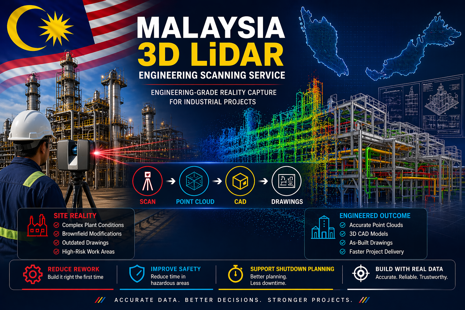
Malaysia 3D LiDAR Engineering Scanning Service

3D LiDAR scanning of a Malaysian industrial plant showing point cloud data converted into CAD models and engineering drawings

Malaysia is a major hub for industrial activity across oil and gas, manufacturing, palm oil processing, and infrastructure. These facilities are often complex environments where accuracy is critical to project success.

Hamilton By Design provides Malaysia 3D LiDAR engineering scanning services, delivering accurate site data that supports safer, faster, and more reliable engineering outcomes.

Traditional measurement methods rely on outdated drawings, manual measurements, and assumptions. Over time, industrial plants change, and what exists on paper often does not reflect what has actually been built.

This creates risk across design, fabrication, and installation.

3D LiDAR scanning removes this uncertainty. Using high-speed laser measurement, millions of data points are captured to create a point cloud. This point cloud represents the exact geometry of the site as it exists in reality.

The data can then be converted into 3D CAD models and engineering drawings, providing a reliable foundation for project delivery.

3D LiDAR scanning and 3D modelling service button โ€” laser scanner capturing a point cloud for engineering and CAD modelling
Mechanical engineering services

The benefits are immediate.

Engineering accuracy improves because designs are based on real-world conditions. Clash detection can be completed before fabrication begins, reducing rework and avoiding costly delays.

Project timelines are reduced. Engineering teams can work remotely using accurate data, limiting the need for repeated site visits.

Safety is improved by reducing the time spent in hazardous environments. This is especially important during shutdowns and brownfield upgrades.

Shutdown planning becomes more effective. Components can be prefabricated, installation can be planned in detail, and downtime can be minimised.

Most importantly, 3D LiDAR scanning provides true as-built documentation. Every visible element of the plant is captured, allowing accurate layouts, sections, and models to be generated without returning to site.

The real value comes from the workflow.

Scan the site.
Process the point cloud.
Build the CAD model.
Produce engineering drawings.

This process transforms raw data into practical, engineering-ready deliverables that can be used across the full lifecycle of a project.

These services are widely used across oil and gas facilities, palm oil processing plants, manufacturing operations, mining infrastructure, and power generation sites throughout Malaysia.

Typical applications include plant upgrades, structural modifications, equipment installations, and shutdown planning.

In todayโ€™s environment, projects are expected to be delivered faster, safer, and with greater accuracy. 3D LiDAR scanning supports these outcomes by ensuring decisions are based on real data rather than assumptions.

If you are planning an upgrade, shutdown, or new installation within an industrial facility in Malaysia, accurate information is critical.

To learn more about how Hamilton By Design can support your project, visit:

Talk to Us – Contact Us

Name
Would you like us to arrange a phone consultation for you?
Address
3D CAD Modelling Australia service banner for Hamilton By Design

Our clients

3D LiDAR Scanning Darwin for engineering surveys, laser scanning, reality capture and point cloud modelling services
3D LiDAR Scanning Australia engineering services for laser scanning, reality capture, scan-to-CAD, Scan-to-BIM and as-built documentation across Australia
3D LiDAR scanning services on the Central Coast providing engineering-grade laser scanning, point cloud capture, scan-to-CAD modelling and industrial reality capture for infrastructure and industrial projects.
3D LiDAR Scanning Perth for engineering surveys, laser scanning, reality capture and point cloud modelling services
3D LiDAR Scanning Sydney for engineering surveys, laser scanning, reality capture and point cloud modelling services
3D LiDAR Scanning Brisbane for engineering surveys, laser scanning, reality capture and point cloud modelling services
3D LiDAR Scanning Canberra for engineering surveys, laser scanning, reality capture and point cloud modelling services
3D LiDAR Scanning Newcastle for engineering surveys, laser scanning, reality capture and point cloud modelling services
3D LiDAR Scanning Adelaide for engineering surveys, laser scanning, reality capture and point cloud modelling services

Structural Drafting Sydney

Structural drafting workflow showing LiDAR scanning, point cloud modelling, and steel detailing for accurate construction in Sydney

Structural Drafting Sydney | Engineering-Grade CAD & Steel Detailing

Engineering-Grade Detailing for Real-World Construction

Structural steel I-beam bolted connection with column in isometric view.

Structural drafting in Sydney is often treated as a documentation exercise โ€” but in reality, it sits at the critical junction between design intent and construction reality.

At Hamilton By Design, we approach structural drafting as an engineering-led process, not just linework. By combining 3D LiDAR scanning, SolidWorks modelling, and practical site experience, we ensure drawings reflect what is actually built โ€” not what was assumed.


Why Structural Drafting Matters in Sydney

Sydney presents unique challenges:

  • Dense urban environments
  • Brownfield upgrades and legacy infrastructure
  • Tight construction tolerances
  • Multi-disciplinary coordination (mechanical, civil, structural)

Traditional drafting methods often rely on:

  • Outdated drawings
  • Manual measurements
  • Assumptions based on design models

This creates risk.


3D LiDAR scanning and 3D modelling service button โ€” laser scanner capturing a point cloud for engineering and CAD modelling
Mechanical engineering services

The Problem with Traditional Drafting

In many projects, structural drawings are created without verifying real-world conditions. This leads to:

  • Misaligned steelwork
  • Rework on-site
  • Fabrication errors
  • Cost overruns
  • Delays during installation

The issue is simple:
Design models โ‰  As-built reality


Our Approach: Scan โ†’ Model โ†’ Detail

We solve this using an engineering-grade workflow:

1. 3D Laser Scanning (LiDAR)

Using FARO terrestrial scanners, we capture accurate site geometry:

  • Steel structures
  • Concrete interfaces
  • Existing services
  • Connection points

Deliverables:

  • Registered point clouds (.E57, .RCP)
  • Full site coverage with traceable accuracy

2. Point Cloud to CAD Modelling

We convert reality into usable engineering models:

  • Clean, simplified geometry
  • Fabrication-ready references
  • Clash-aware modelling

3. Structural Drafting & Detailing

We produce:

  • GA drawings
  • Shop drawings
  • Sections and elevations
  • Connection details
  • Platework and steel member detailing

All drawings are structured for:

  • Fabrication
  • Installation
  • Compliance

Why Engineering-Led Drafting Wins

Most drafting services are CAD-driven.
We are engineering-driven.

This means:

  • Load paths are understood
  • Connections are practical
  • Fabrication methods are considered
  • Site constraints are built into the design

Sydney Project Applications

Our structural drafting services are ideal for:

  • Industrial plants
  • Mining infrastructure
  • Structural upgrades
  • Conveyor systems and transfer stations
  • Platforms, walkways, and access systems
  • Retrofit steelwork in existing buildings

The Role of Digital Engineering & Governance

By integrating with the 3DEXPERIENCE platform, we provide:

  • Version-controlled drawings
  • Full revision history
  • Chain of custody for engineering data
  • 24/7 access for stakeholders

This ensures:

  • One source of truth
  • Reduced miscommunication
  • Audit-ready documentation

Key Benefits

  • Reduced rework and site delays
  • Accurate fabrication first time
  • Faster project delivery
  • Improved safety and compliance
  • Better coordination across disciplines

Hamilton By Design logo displayed on a blue tilted rectangle with a grey gradient background

Hamilton By Design

Structural drafting in Sydney should not rely on guesswork.

By combining:

  • Reality capture (LiDAR scanning)
  • Engineering modelling
  • Practical drafting experience

Hamilton By Design delivers drawings that match reality โ€” not assumptions.


Industries We Support

Our structural drafting services support manufacturing facilities, industrial plants, commercial buildings, rail infrastructure, water treatment facilities and resource sector projects throughout Sydney.

Hamilton By Design prepares structural steel drawings, fabrication details, general arrangement drawings and as-built documentation to support construction, maintenance and asset improvement projects.

Hamilton By Design provides structural drafting services throughout Sydney CBD, Parramatta, Liverpool, Penrith, Chatswood, Alexandria, Mascot, Newcastle and the Central Coast. We prepare structural steel drawings, fabrication details, general arrangement drawings and as-built documentation for industrial, infrastructure and commercial projects.


Call to Action

If your project requires accurate, buildable structural drawings, contact:

Hamilton By Design
Engineering-led drafting and 3D scanning services across Sydney

Our clients

3D CAD Modelling Australia service banner for Hamilton By Design

Talk to Us – Contact Us

Name
Would you like us to arrange a phone consultation for you?
Address
3D Scanning Sydney banner promoting engineering-grade 3D laser scanning, LiDAR scanning, and reality capture services by Hamilton By Design.
Mechanical Engineering Sydney banner with white text on a blue background representing Hamilton By Design's mechanical engineering services in Sydney.
Mechanical Drafting and 3D Modelling Sydney banner highlighting Hamilton By Design's CAD drafting, 3D modelling, and engineering design services in Sydney.


Mechanical Engineering | Structural Engineering


Hamilton By Design provides engineering-led 3D scanning, LiDAR scanning, mechanical engineering and digital engineering services throughout Sydney and Greater Sydney.

Explore our related Sydney services:


  • 3D Scanning Sydney โ€“ Engineering-grade terrestrial laser scanning, as-built surveys and point cloud capture for industrial, infrastructure and commercial projects.
  • Reality Capture Sydney โ€“ High-accuracy reality capture, digital twins, asset documentation and engineering-grade site verification.
  • Scan to CAD Sydney โ€“ Convert point cloud data into AutoCAD, SolidWorks, Inventor and other engineering-ready CAD deliverables.
  • Point Cloud Modelling Sydney โ€“ Engineering-grade point cloud processing, clash detection, as-built verification and 3D modelling.
  • Mechanical Engineering Sydney โ€“ Mechanical design, plant upgrades, materials handling systems, conveyors, chutes, platforms and engineering support.
  • Structural Drafting Sydney โ€“ Structural steel drafting, fabrication drawings, GA drawings, workshop detailing and as-built documentation.

Hamilton By Design supports projects throughout Sydney CBD, Parramatta, Liverpool, Penrith, Blacktown, Chatswood, Alexandria, Mascot, Newcastle and the Central Coast.


Blue banner graphic displaying the text "Point Cloud to CAD - Australia" in large white lettering, representing point cloud processing, scan-to-CAD conversion and digital engineering services across Australia.

Blue banner graphic displaying the text "Scan to CAD Sydney" in large white lettering, representing engineering-led point cloud to CAD conversion, LiDAR scanning and digital engineering services in Sydney.

Blue banner graphic displaying the text "Reality Capture Sydney - CBD" in large white lettering, representing engineering-led reality capture, LiDAR scanning and digital engineering services within Sydney CBD commercial buildings and infrastructure.

Laser Scanning for Engineering

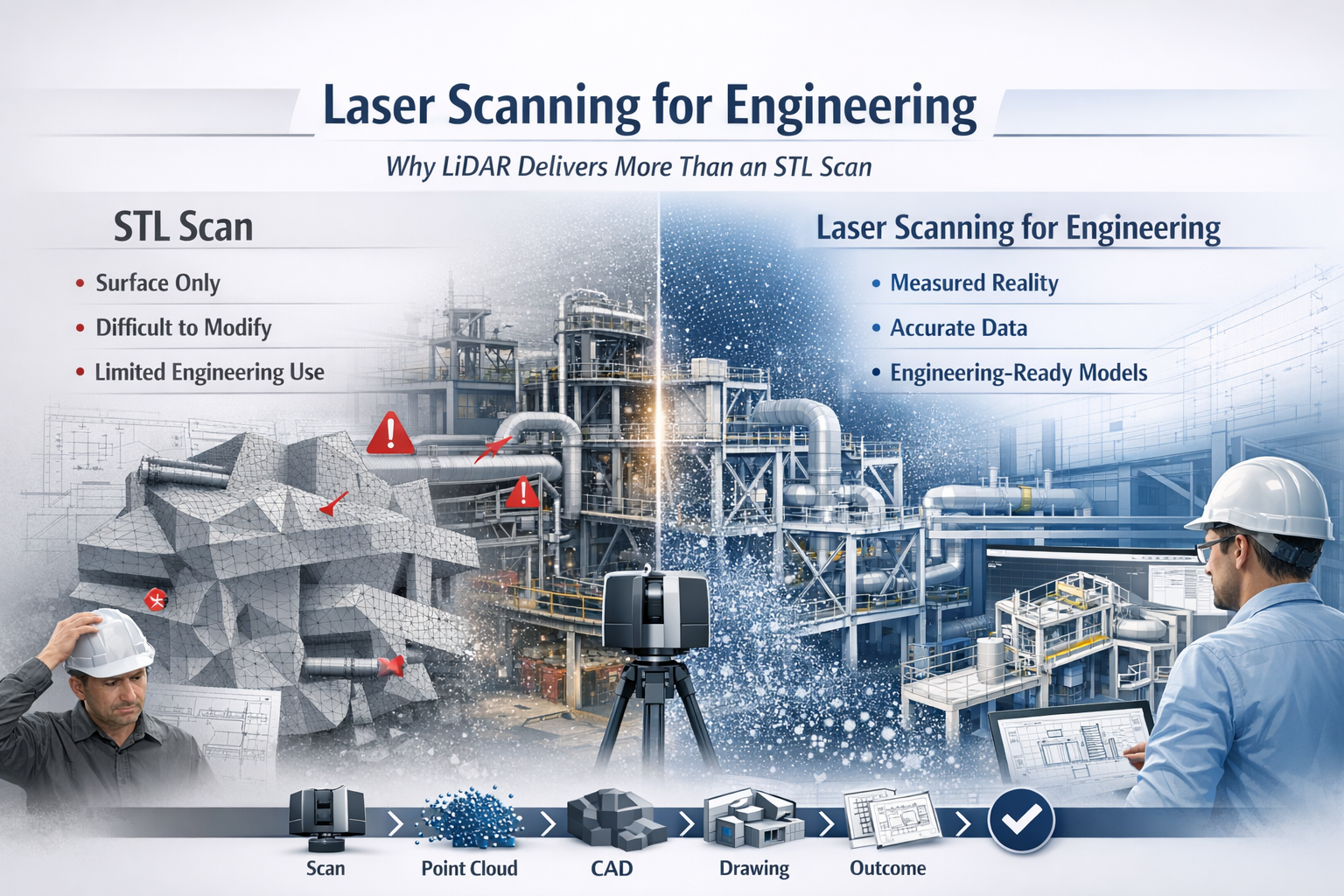
Laser scanning for engineering infographic comparing LiDAR point cloud data with STL mesh scanning, showing improved CAD modelling and engineering workflows.

Why LiDAR Delivers Real Engineering Outcomes

In modern engineering, accuracy is everything. Whether you are working in mining, manufacturing, infrastructure, or plant design, the difference between success and costly rework often comes down to how well you understand what has actually been built.

This is where laser scanning for engineering has become a critical tool.

While many providers offer โ€œ3D scanning,โ€ not all data is created equal. There is a significant difference between engineering-grade LiDAR point cloud data and basic STL mesh outputs. Understanding that difference can determine whether your project moves forward efficientlyโ€”or gets stuck in rework, assumptions, and redesign.


3D LiDAR scanning and 3D modelling service button โ€” laser scanner capturing a point cloud for engineering and CAD modelling
Mechanical engineering services

What is Laser Scanning for Engineering?

Laser scanning for engineering uses LiDAR (Light Detection and Ranging) technology to capture millions of precise measurements of a physical environment. The result is a high-density point cloudโ€”a true digital representation of reality.

Unlike traditional measurement methods, LiDAR captures:

  • Complex geometry
  • Structural relationships
  • Equipment positioning
  • Real-world deviations from design

This data becomes the foundation for:

  • CAD modelling (SolidWorks, AutoCAD, Revit)
  • Engineering drawings
  • Clash detection
  • Retrofit and upgrade design

In short, it bridges the gap between design intent and as-built reality.


The Problem with STL-Based Scanning

Many scanning providers deliver outputs as STL, OBJ, or mesh files. While these formats are useful for visualisation or 3D printing, they fall short in engineering applications.

Key limitations of STL scans:

  • No intelligence โ€“ Meshes are just surfaces, not structured geometry
  • Difficult to modify โ€“ Not suitable for parametric design workflows
  • Poor for engineering drawings โ€“ Cannot easily generate sections, tolerances, or fabrication details
  • Heavy and inefficient โ€“ Large file sizes with limited usability
  • No clear chain of accuracy โ€“ Hard to verify measurement reliability

In practical terms, an STL file often becomes a dead-end deliverableโ€”you can look at it, but you canโ€™t engineer from it effectively.


Why LiDAR Point Clouds Are Built for Engineering

LiDAR-based laser scanning for engineering produces structured, measurable, and verifiable data that integrates directly into engineering workflows.

Key advantages:

1. True-to-Reality Accuracy

Point clouds capture millions of measured points, providing a high-confidence representation of the real world.

2. Direct CAD Integration

Data can be converted into:

  • Parametric 3D models
  • Fabrication-ready drawings
  • Plant layouts and assemblies

3. Supports Engineering Decisions

Engineers can:

  • Measure directly from the dataset
  • Validate clearances and tolerances
  • Design with confidence

4. Enables Retrofit and Brownfield Design

In existing plants, nothing is ever exactly โ€œas drawn.โ€ LiDAR ensures your design fits what is actually there, not what was intended years ago.

5. Reduces Risk and Rework

Accurate input data leads to:

  • Fewer site revisits
  • Reduced fabrication errors
  • Lower project costs

6. Maintains Chain of Custody

Engineering-grade scanning supports data governance, traceability, and verificationโ€”critical in legal, compliance, and high-risk environments.


Engineering vs Visualisation: A Critical Distinction

A key misunderstanding in the industry is assuming all 3D scanning is equal.

  • STL / Mesh Scanning โ†’ Visualisation Output
  • LiDAR Point Cloud โ†’ Engineering Input

If your goal is:

  • 3D printing โ†’ STL may be enough
  • Engineering design, fabrication, or upgrades โ†’ LiDAR is essential

Real-World Application: Engineering in Practice

Across mining, manufacturing, and infrastructure, laser scanning for engineering is used to:

  • Capture conveyor systems before modification
  • Model structural steel for upgrades
  • Verify equipment installation
  • Design pipework and mechanical systems
  • Plan shutdown works with precision

Instead of guessing dimensions or relying on outdated drawings, engineers work from measured reality.


The Workflow That Delivers Results

A proper engineering workflow looks like this:

Scan โ†’ Register โ†’ Model โ†’ Detail โ†’ Deliver

Not:

Scan โ†’ Export STL โ†’ End

That difference defines whether you receive a usable engineering deliverable or just a digital artifact.


3D CAD Modelling Australia service banner for Hamilton By Design

Laser scanning for engineering is not just about capturing dataโ€”itโ€™s about enabling better engineering outcomes.

LiDAR-based point cloud data provides:

  • Accuracy
  • Usability
  • Engineering value

In contrast, STL-based scanning often limits what you can achieve.

If your project requires real design, real drawings, and real decisions, then the choice is clear:

Use laser scanning for engineeringโ€”not just scanning for appearance.

Our clients

Contact Us

Name
Would you like us to arrange a phone consultation for you?
Address
3D CAD Modelling Australia service banner for Hamilton By Design
Australian Drafting logo featuring bold white text reading "Australian Drafting" centred on a blue rounded rectangle background.
Engineering Governance title graphic featuring bold white text reading "Engineering Governance" centred on a blue rounded rectangle background.
Mechanical, Structural & Pipework Drafting service banner by Hamilton By Design featuring white text on a blue background.
Mechanical engineering services
Blue rounded button with the text โ€œSolidWorks Designโ€ in white.
Finite Element Analysis (FEA) engineering simulation button
3D LiDAR Scanning Darwin for engineering surveys, laser scanning, reality capture and point cloud modelling services
3D LiDAR Scanning Australia engineering services for laser scanning, reality capture, scan-to-CAD, Scan-to-BIM and as-built documentation across Australia
3D LiDAR scanning services on the Central Coast providing engineering-grade laser scanning, point cloud capture, scan-to-CAD modelling and industrial reality capture for infrastructure and industrial projects.
3D LiDAR Scanning Perth for engineering surveys, laser scanning, reality capture and point cloud modelling services
3D LiDAR Scanning Sydney for engineering surveys, laser scanning, reality capture and point cloud modelling services
3D LiDAR Scanning Brisbane for engineering surveys, laser scanning, reality capture and point cloud modelling services
3D LiDAR Scanning Canberra for engineering surveys, laser scanning, reality capture and point cloud modelling services
3D LiDAR Scanning Newcastle for engineering surveys, laser scanning, reality capture and point cloud modelling services
3D LiDAR Scanning Adelaide for engineering surveys, laser scanning, reality capture and point cloud modelling services

Weโ€™re Getting It Wrong on Site (And Itโ€™s Costing More Than You Think)

Engineering-grade 3D laser scanner capturing Sydney industrial plant with point cloud overlay transitioning into CAD model

Thereโ€™s a problem happening on projects across Australia right now:

Design says one thing. Site builds another.

And no one realises until itโ€™s too late.


The Real Issue: Miscommunication Between Design and Build

Itโ€™s not that people arenโ€™t doing their job.

Itโ€™s that the information theyโ€™re working from isnโ€™t aligned.

  • Drawings donโ€™t reflect reality
  • Existing plant conditions are assumed, not verified
  • Fabrication is based on outdated or incomplete data
  • Site modifications happen on the fly

๐Ÿ‘‰ The result?

  • Rework
  • Delays
  • Cost blowouts
  • Frustrated teams

This is where most projects quietly bleed money.


3D LiDAR scanning and 3D modelling service button โ€” laser scanner capturing a point cloud for engineering and CAD modelling
Mechanical engineering services

โ€œWe Thought It Would Fitโ€ฆโ€ โ€” The Most Expensive Words on Site

If youโ€™ve ever heard:

  • โ€œThatโ€™s not what we expected on siteโ€
  • โ€œWeโ€™ll just make it workโ€
  • โ€œCan we modify it during install?โ€

Youโ€™re already in reactive mode.

And reactive mode is where projects lose control.


So What Are the Best 3D Scanning Platforms to Fix This?

Letโ€™s be clear:

๐Ÿ‘‰ Itโ€™s not just about the scanner
๐Ÿ‘‰ Itโ€™s about how the data is captured, interpreted, and delivered

But hereโ€™s how the platforms stack up in the real world:


1. FARO Focus (Engineering-Grade Reality Capture)

โœ” High accuracy (millimetre-level)
โœ” Ideal for brownfield industrial environments
โœ” Reliable for mechanical design, pipework, and structural interfaces

๐Ÿ’ก This is where engineering-led scanning matters

Anyone can scan.
Not everyone understands line-of-sight constraints, coverage, and design intent.


2. Leica RTC360 (Speed + Visualisation)

โœ” Fast capture and good for large areas
โœ” Strong visual workflows
โœ” Great for general site documentation

โš  But without engineering oversight, you still risk:

  • Missing critical geometry
  • Poor scan coverage
  • Misalignment with fabrication requirements

3. NavVis / Mobile Scanning (Speed Over Precision)

โœ” Rapid walkthrough capture
โœ” Useful for high-level coordination

โš  Not suitable for:

  • Fabrication-level accuracy
  • Mechanical interfaces
  • Detailed engineering design

The Truth Most People Miss

The platform doesnโ€™t fix the problem.

๐Ÿ‘‰ Engineering-led scanning does.


Why Engineering-Led Scanning Changes Everything

At Hamilton By Design, we donโ€™t just โ€œscan a siteโ€.

We capture it like engineers who have to design and build from it.

That means:

  • Understanding what needs to be modelled โ€” and what doesnโ€™t
  • Managing line-of-sight to eliminate data gaps
  • Delivering point clouds that actually support design decisions
  • Producing models and drawings that match real-world conditions

From Scan โ†’ Model โ†’ Build (No Guesswork)

When done properly, 3D scanning becomes:

โœ” A single source of truth
โœ” A digital twin of your site
โœ” A way to align design, fabrication, and installation

No assumptions.
No โ€œweโ€™ll fix it on siteโ€.
No disconnect.


If Youโ€™re Getting It Wrong on Site โ€” This Is Why

Itโ€™s not your team.

Itโ€™s the gap between:

๐Ÿ‘‰ What was designed
๐Ÿ‘‰ And what actually exists


Fix the Gap โ€” Not the Symptoms

If youโ€™re serious about reducing rework, delays, and cost blowouts:

๐Ÿ‘‰ Start with accurate, engineering-grade site data


Learn More

Explore how we deliver engineering-led 3D scanning in Sydney:


Name
Would you like us to arrange a phone consultation for you?
Address

3D CAD Modelling Australia service banner for Hamilton By Design

Mechanical Engineering | Structural Engineering


3D LiDAR Scanning Darwin for engineering surveys, laser scanning, reality capture and point cloud modelling services
3D LiDAR Scanning Australia engineering services for laser scanning, reality capture, scan-to-CAD, Scan-to-BIM and as-built documentation across Australia
3D LiDAR scanning services on the Central Coast providing engineering-grade laser scanning, point cloud capture, scan-to-CAD modelling and industrial reality capture for infrastructure and industrial projects.