AI Needs a Body โ€“ Why Point Cloud Data Powers the Next Generation of Engineering

AI needs a body concept showing STL mesh, point cloud data, and CAD model with FEA for engineering workflow

Engineering is entering a new phase.

Artificial intelligence is being integrated into design platforms, automation is accelerating workflows, and digital engineering environments are becoming more connected than ever before. Tools such as SolidWorks are now introducing AI assistants like AURA, LEO, and Marie, promising smarter design, faster modelling, and improved decision-making.

But there is a fundamental issue that is often overlooked:

AI cannot design, validate, or optimise anything without a physical reference.
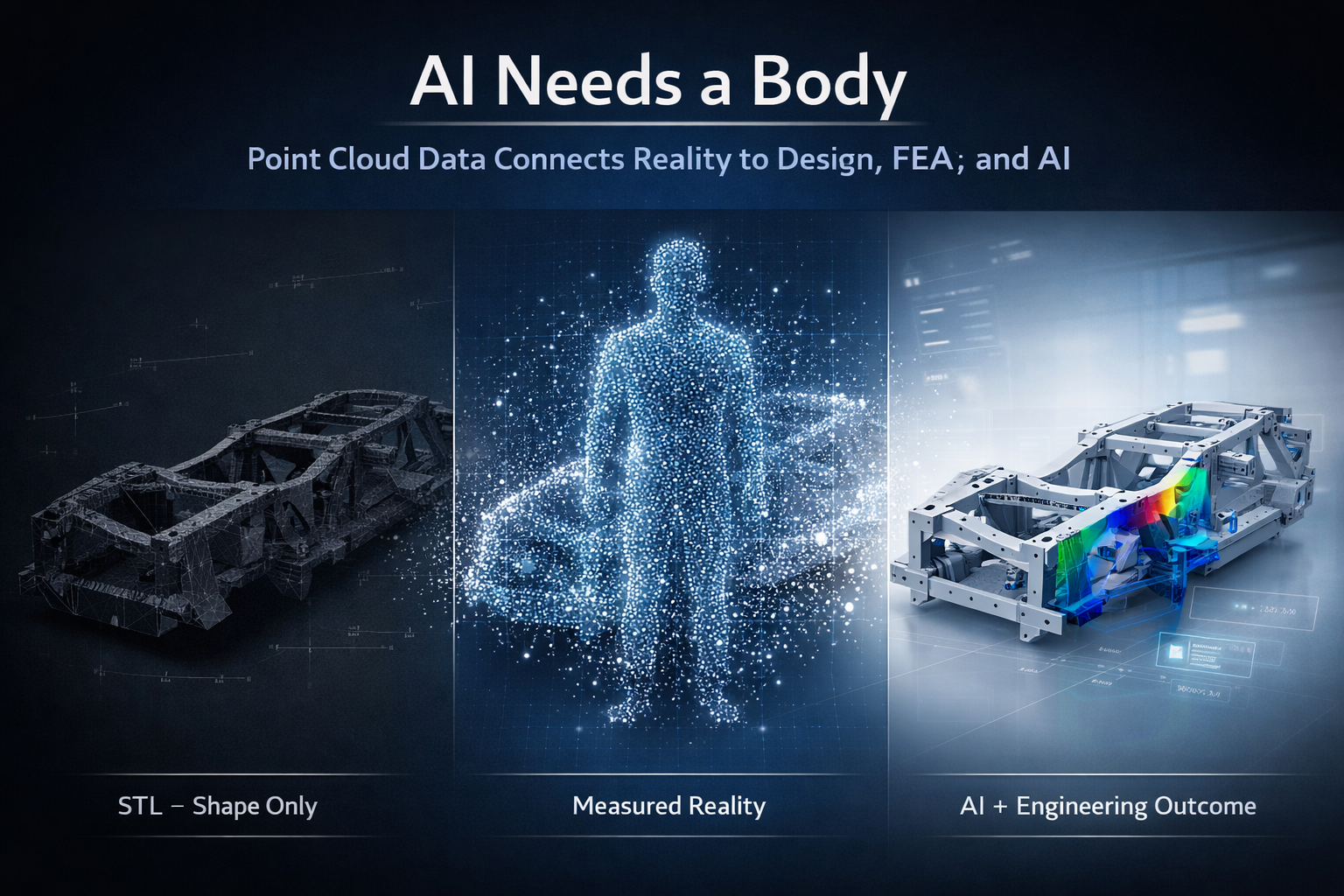
AI needs a body.

And in engineering, that body is real-world, measurable data.

3D point cloud scanning provides that foundation.


3D LiDAR scanning and 3D modelling service button โ€” laser scanner capturing a point cloud for engineering and CAD modelling
Mechanical engineering services

Gen 1, Gen 2, Gen 3 โ€“ The Evolution of Engineering

Engineering workflows can be broadly understood in three stages: Gen 1, Gen 2, and Gen 3.

Gen 1 was manual. Tape measures, site sketches, and experience-driven decisions formed the basis of design. While effective for its time, it relied heavily on interpretation and often resulted in rework due to incomplete data.

Gen 2 introduced CAD platforms such as SolidWorks, Autodesk Inventor, Autodesk Fusion, and Onshape. This enabled parametric modelling, faster iteration, and improved documentation. However, Gen 2 introduced a new problemโ€”designs were often disconnected from reality. Models were built based on assumptions, outdated drawings, or incomplete site data.

Even when scanning was introduced, the workflow often stopped at STL or OBJ files. These formats are visual representations only. They are static, faceted, and lack the structure required for engineering.

Gen 3 represents the shift to reality-based engineering. This is where point cloud scanning, CAD, FEA, AI, and lifecycle management systems all connect. The key difference is that models are no longer based on assumptionsโ€”they are derived from measured reality.


The Problem With STL Workflows

STL files are commonly produced by handheld or metrology-grade scanners. They are easy to generate and provide a visually accurate representation of a component.

However, an STL file is a triangulated mesh. It contains no features, no relationships, and no design intent. It is a surface approximation made up of flat facets.

This creates a major limitation.

An STL file can show what something looks like, but it cannot define how it functions, how it should be modified, or how it should be manufactured.


Why FEA on STL Is Not Best Practice

It is technically possible to run Finite Element Analysis (FEA) on an STL file, but it is not considered best practice.

The reasons are straightforward.

The geometry is not true. Surfaces are faceted, holes are not perfect circles, and edges are broken into triangles. This makes it difficult to apply loads and boundary conditions accurately.

Because the STL is already a mesh, FEA introduces a second mesh on top of it. This reduces control over element quality and can affect convergence and accuracy.

Most importantly, the results are based on an approximation rather than engineered geometry.

You are analysing a surface representation, not a design.

For engineering decisions, this creates risk. Results become difficult to verify, defend, or repeat.


AI Has the Same Limitation

AI assistants such as AURA, LEO, and Marie are designed to work inside CAD environments. They rely on structured, parametric data to assist with modelling, optimisation, and decision-making.

They are highly effective when working with:

  • Defined features
  • Parametric relationships
  • Clean geometry

But when given an STL file, AI faces the same problem as the engineer.

There are no features to interpret, no constraints to follow, and no design intent to understand. The data is simply a collection of triangles.

As a result:

AI cannot meaningfully design or optimise from an STL file.

It can attempt to approximate geometry, but it cannot guarantee accuracy, intent, or engineering reliability.


AI Needs a Body

AI is often described as the brain of the future engineering workflow.

But a brain alone is not enough.

Without a body:

  • There is no spatial context
  • No physical reference
  • No connection to reality

In engineering, the body is the physical asset captured in digital form.

This is where point cloud scanning becomes critical.


Point Cloud โ€“ The Body for Engineering and AI

Point cloud data captures millions of measured points in three-dimensional space. Each point represents a real-world coordinate.

This provides:

  • True geometry
  • Accurate spatial relationships
  • Complete environmental context

Unlike STL files, point clouds are not simplified or interpreted. They represent measured reality.

From this data, engineers can:

  • Extract accurate dimensions
  • Fit planes, cylinders, and features
  • Build parametric CAD models
  • Maintain traceability back to the original scan

This creates a reliable foundation for both engineering and AI.


The Correct Engineering Workflow

A robust, engineering-grade workflow follows a clear sequence:

Scan โ†’ Point Cloud โ†’ CAD Model โ†’ FEA โ†’ AI โ†’ Engineering Outcome

Each step adds value.

The scan captures reality.
The point cloud preserves it.
The CAD model structures it.
FEA validates it.
AI enhances it.

Without the point cloud, the entire process loses its connection to reality.


Vehicle Chassis Example

Consider the development or modification of a vehicle chassis.

Using an STL-based workflow, the process typically involves rebuilding geometry from a mesh, applying FEA to an approximation, and attempting to optimise the design without a reliable reference. This introduces risk in alignment, load paths, and final fitment.

Using a point cloud-based workflow, the chassis is scanned and modelled directly from measured data. FEA is applied to true geometry, and AI tools such as AURA, LEO, and Marie can assist in refining and optimising the design.

The result is accurate, repeatable, and ready for manufacturing.


Digital Twin, PLM, and the 3D Environment

Point cloud data also supports broader engineering systems, including Digital Mock-Up (DMU), Product Data Management (PDM), and Product Lifecycle Management (PLM).

These systems rely on a single source of truth.

Point cloud data provides that truth by ensuring alignment between the digital model and the physical asset.

This enables:

  • Lifecycle tracking
  • Design validation
  • Ongoing updates and modifications

It also supports Digital Twin environments, where the physical and digital worlds remain connected over time.


Manufacturing in Australia

For manufacturing, accuracy is critical.

Point cloud-driven workflows ensure that:

  • Components fit as intended
  • Drawings reflect real-world conditions
  • Rework is minimised
  • Fabrication is efficient

This is particularly important for local manufacturing in Australia, where precision and reliability directly impact cost and delivery.


The Bottom Line

It is not best practice to run FEA on an STL file. It is not effective to design from an STL file. And it is unrealistic to expect AI to compensate for poor input data.

STL files provide a visual reference, but they do not provide a foundation for engineering.

AI is a powerful tool, but it cannot operate without accurate, structured data.

AI cannot fix a workflow that starts with the wrong data.


Final Thought

Engineering is evolving.

Gen 1 was manual.
Gen 2 was digital.
Gen 3 is reality-based and AI-assisted.

AI is not the starting point. Data is.

And in modern engineering:

AI needs a body.
Point cloud scanning is that body.

Our Clients

Finite Element Analysis (FEA) engineering simulation button
Mechanical engineering services

Why Point Cloud Data Beats STL for Real Engineering Work

Point cloud to CAD workflow showing transition from STL mesh to engineering-ready parametric model with dimensions and drawings

In the world of 3D scanning, there is often confusion around what type of data is actually useful for engineering. Many providers offer high-accuracy scanning using metrology-grade equipment, yet the final deliverable is often limited to STL or OBJ files.

The question is simple:
If the data cannot be used inside your CAD system, what is its real value?


The Rise of Metrology-Grade Scanning

Modern handheld scanners are incredibly capable. They can capture fine detail, achieve high accuracy, and generate dense surface representations of components. These systems are often used in reverse engineering, product design, and inspection workflows.

They are frequently marketed as โ€œmetrology-grade,โ€ and in terms of capture capability, that claim is valid. These scanners can measure to very tight tolerances and produce highly detailed digital representations.

However, the real issue is not how the data is captured.
It is how the data is delivered and how it integrates into engineering workflows.

Capturing accurate data is only the first step. The true value lies in whether that data can be used to design, modify, verify, and manufacture real-world components.


STL and OBJ โ€“ A Surface, Not a Solution

STL and OBJ files are mesh-based formats. They represent the surface of an object using thousands or millions of triangles stitched together to form a 3D shape.

These files are useful for:

  • Visualisation
  • 3D printing
  • Basic reference and communication

They are fast to generate and easy to share, which is why many scanning providers stop at this stage.

However, they come with significant limitations:

  • No parametric geometry
  • No selectable engineering features
  • No design intent
  • Difficult to dimension accurately
  • Cannot drive CAD models effectively

A mesh file is essentially a visual representation, not an engineering model.

In simple terms:

An STL file shows what something looks like, but not how to design, modify, or manufacture it.

Once the data is converted into a mesh, it is often smoothed, simplified, and processed. This means the original measured data is no longer fully preserved, and any measurements taken from the mesh are based on an interpreted surface rather than raw coordinates.


Engineering Happens in CAD

Real engineering work takes place inside platforms such as SolidWorks, Autodesk Inventor, Autodesk Fusion, and Onshape.

These tools are built around:

  • Parametric modelling
  • Feature-based design
  • Relationships and constraints
  • Editable geometry

They rely on identifiable features such as:

  • Planes
  • Cylinders
  • Holes
  • Edges and faces

Mesh files do not contain this level of intelligence. As a result, they cannot be easily used to:

  • Modify or optimise designs
  • Perform engineering calculations or simulations
  • Generate fabrication-ready drawings
  • Maintain consistency across revisions

This creates a disconnect:

You can measure on the scanner, but you cannot effectively design in CAD.

And if design cannot happen in CAD, the workflow breaks down.


The Advantage of Point Cloud Data

Point cloud data, typically delivered in formats such as E57 or RCP, captures real-world coordinates directly from the scan. Each point represents a measurable location in 3D space.

This is fundamentally different from a mesh.

Point clouds provide:

  • True measured data (not interpreted surfaces)
  • High-density spatial accuracy
  • Full capture of the environment or component
  • The ability to revisit and re-measure at any time

This enables engineers to:

  • Extract accurate dimensions directly from real-world data
  • Fit geometry (planes, cylinders, centre lines) inside CAD
  • Validate designs against existing conditions
  • Maintain traceability and confidence in the data

Point clouds form the foundation for engineering-grade modelling, not just visual representation.


From Scan to Engineering Outcome

At Hamilton By Design, the focus is not just on capturing data, but on delivering usable engineering outcomes.

Our workflow is:

Scan โ†’ Point Cloud โ†’ CAD Model โ†’ Engineering Drawings

This ensures the data can be:

  • Measured inside CAD
  • Verified and checked against real conditions
  • Modified to suit design requirements
  • Used for fabrication, installation, and real-world implementation

This approach bridges the gap between reality and design.

It turns captured data into something that engineers, fabricators, and project teams can actually use.


Like-for-Like vs Design Flexibility

If your requirement is a like-for-like digital representation of an object, mesh files such as STL or OBJ may be sufficient.

They provide a quick and effective way to visualise shape and form.

However, if your goal is to:

  • Modify a design
  • Integrate with existing infrastructure
  • Produce engineering drawings
  • Support fabrication or installation

Then flexibility becomes critical.

If youโ€™re looking for like-for-like, mesh will get you there.
If youโ€™re looking for a flexible design tool, point cloud is the answer.


The Bottom Line

Metrology-grade scanners can capture extremely accurate data. But if that data is delivered only as an STL or OBJ file, its value is significantly limited within an engineering context.

True value comes from transforming scan data into something that works inside CAD and supports real-world outcomes.

Mesh files deliver a shape.
Point clouds deliver a foundation for engineering.

3D CAD Modelling Australia service banner for Hamilton By Design
Finite Element Analysis (FEA) engineering simulation button
Mechanical engineering services

How 3D Laser Scanning is Used in Sydney Projects

Technician using a tripod-mounted 3D laser scanner inside a Sydney building project with digital scan data visible.
Blue 3D LiDAR scanner icon on a tripod with scanning waves

3D laser scanning is being used across Sydney projects to capture accurate existing conditions before design, construction, upgrades, and maintenance work begins. In construction and industrial environments, this technology helps reduce guesswork by providing a reliable digital record of what is actually on site.

For project teams working in live buildings, industrial plants, infrastructure corridors, and brownfield environments, 3D laser scanning can support safer planning, faster design development, and more accurate engineering decisions.

Why 3D Laser Scanning Matters

Many Sydney projects take place in environments where existing information is incomplete, outdated, or missing altogether. Legacy drawings may not reflect years of modifications, and manual site measurements often miss the detail needed for confident design and drafting.

3D laser scanning helps solve that problem by capturing large areas quickly and turning real site conditions into digital information that can be reviewed, measured, modelled, and referenced during project delivery.

This is especially useful where:

  • access is difficult
  • shutdown windows are short
  • geometry is complex
  • services are congested
  • existing drawings are unreliable
  • rework risk needs to be reduced

How 3D Laser Scanning is Used in Sydney Construction Projects

In construction, 3D laser scanning is commonly used to capture existing buildings, structures, and services before new work begins. This helps design teams understand the actual site condition rather than relying only on old plans or assumptions.

Typical construction uses include:

  • existing building surveys
  • faรงade and structural capture
  • service coordination
  • refurbishment and fitout planning
  • steelwork measurement
  • as-built verification
  • clash checking before installation
  • scanning of plant rooms, roof spaces, basements, and service risers

For Sydney construction projects, this can be particularly valuable in older buildings, confined plant areas, and staged redevelopment works where accuracy matters.

How 3D Laser Scanning is Used in Industrial Projects

3D laser scanning is also widely used in industrial and engineering projects across Sydney. This includes manufacturing facilities, processing plants, utilities infrastructure, materials handling systems, and brownfield upgrade works.

Common industrial applications include:

  • capturing conveyors, chutes, tanks, pipework, and steel structures
  • documenting existing plant before modifications
  • scan-to-CAD modelling
  • drafting support for upgrades and shutdowns
  • tie-in planning for new equipment
  • layout verification before fabrication
  • structural and mechanical design support
  • point cloud capture for engineering review

For industrial sites, one of the biggest advantages is being able to capture the true geometry of operating plant areas before mechanical or structural work begins.

Use in Brownfield and Upgrade Projects

Brownfield projects often involve uncertainty. Existing assets may have changed over time, undocumented modifications may exist, and available drawings may not reflect current conditions.

In these cases, 3D laser scanning helps teams capture a reliable baseline before design starts. That information can then be used for:

  • design development
  • as-built documentation
  • drafting updates
  • interference checks
  • equipment replacement planning
  • shutdown preparation
  • fabrication support

This is one of the main reasons laser scanning continues to grow as a practical tool across Sydney engineering and construction work.

Supporting Better Design and Drafting

Laser scanning does not replace engineering or drafting, but it gives those services a much stronger starting point.

Once the site is scanned, the information can be used to support:

  • 2D drafting
  • 3D CAD modelling
  • engineering layouts
  • concept development
  • fabrication drawings
  • plant modification design
  • digital coordination between disciplines

This improves confidence in the next stage of the project and can reduce costly errors caused by poor site information.

Industries Using 3D Laser Scanning in Sydney

3D laser scanning is now used across a wide range of Sydney industries, including:

  • construction
  • commercial buildings
  • manufacturing
  • utilities
  • mining support facilities
  • ports and bulk materials handling
  • infrastructure
  • industrial processing
  • plant maintenance and shutdown work

The value is not limited to one sector. Wherever site accuracy is important, scanning can improve project visibility and reduce risk.

Why Sydney Projects Benefit from 3D Laser Scanning

Sydney projects often involve busy sites, limited access, complex existing infrastructure, and tight project windows. In these conditions, accurate site capture can save time and improve decision-making across the full project lifecycle.

Benefits can include:

  • better visibility of existing conditions
  • reduced reliance on outdated drawings
  • improved coordination between disciplines
  • fewer surprises during fabrication or installation
  • stronger support for engineering and drafting workflows
  • better preparation for upgrades and shutdowns

From Site Capture to Engineering Use

The real value of 3D laser scanning is not just in collecting data. It is in how that data is used.

When integrated into drafting, modelling, and engineering workflows, scanning becomes a practical project tool. It helps bridge the gap between what is on site and what needs to be designed, checked, fabricated, or installed.

For businesses working on Sydney-based construction and industrial projects, this can support better outcomes from the earliest planning stages through to delivery.

Related Service

To learn more about engineering-grade scanning support, visit our pillar page:

Conclusion

3D laser scanning is being used across Sydney projects to improve accuracy, support better planning, and reduce project risk. From construction and building upgrades to industrial plant modifications and engineering design, it provides a reliable way to capture real site conditions before important decisions are made.

As more projects move toward digital engineering and better site verification, 3D laser scanning is becoming an increasingly valuable part of the workflow.

Hamilton By Design logo displayed on a blue tilted rectangle with a grey gradient background

Related Sydney Services

Hamilton By Design provides engineering-led 3D scanning, LiDAR scanning, mechanical engineering and digital engineering services throughout Sydney and Greater Sydney.

Explore our related Sydney services:


  • 3D Scanning Sydney โ€“ Engineering-grade terrestrial laser scanning, as-built surveys and point cloud capture for industrial, infrastructure and commercial projects.
  • Reality Capture Sydney โ€“ High-accuracy reality capture, digital twins, asset documentation and engineering-grade site verification.
  • Scan to CAD Sydney โ€“ Convert point cloud data into AutoCAD, SolidWorks, Inventor and other engineering-ready CAD deliverables.
  • Point Cloud Modelling Sydney โ€“ Engineering-grade point cloud processing, clash detection, as-built verification and 3D modelling.
  • Mechanical Engineering Sydney โ€“ Mechanical design, plant upgrades, materials handling systems, conveyors, chutes, platforms and engineering support.
  • Structural Drafting Sydney โ€“ Structural steel drafting, fabrication drawings, GA drawings, workshop detailing and as-built documentation.

Hamilton By Design supports projects throughout Sydney CBD, Parramatta, Liverpool, Penrith, Blacktown, Chatswood, Alexandria, Mascot, Newcastle and the Central Coast.


3D LiDAR scanning and 3D modelling service button โ€” laser scanner capturing a point cloud for engineering and CAD modelling
Mechanical engineering services
Name
Would you like us to arrange a phone consultation for you?
Address

3D CAD Modelling Australia service banner for Hamilton By Design

Reality Capture Sydney – CBD

Reality capture Sydney showing LiDAR scanning across industrial, construction and infrastructure environments

Reality Capture for Sydney CBD Commercial Buildings


Reality Capture Sydney CBD

Sydney CBD contains some of Australia’s most complex commercial buildings, infrastructure assets and operational facilities. From high-rise office towers and hotels to hospitals, transport infrastructure and critical building services, accurate existing-condition information is essential for successful project delivery.

Hamilton By Design provides engineering-led reality capture services throughout Sydney CBD, combining terrestrial LiDAR scanning, digital engineering and practical industry experience to create accurate digital representations of existing environments.

Reality capture enables project teams to document buildings, plant rooms, building services, infrastructure and operational facilities with a level of detail that traditional measurement methods cannot achieve efficiently. The resulting data can support refurbishment projects, services upgrades, asset management programs, digital twin development, engineering design and construction planning.

By capturing measured reality rather than relying on outdated drawings or assumptions, project teams can reduce risk, improve coordination and make better-informed decisions throughout the project lifecycle.

Reality Capture for Sydney CBD Plant Rooms

Plant rooms within Sydney CBD buildings often contain decades of modifications, undocumented services and limited access for traditional measurement methods.

Reality capture provides a fast and accurate method of documenting mechanical services, pipework, structural steel, cable trays and equipment layouts before engineering design begins.

The resulting point cloud allows project teams to work from measured site conditions, reducing uncertainty and improving coordination throughout the design and construction process.

Many Sydney CBD projects involve HVAC upgrades, chiller replacements, pump room modifications, fire service upgrades and electrical infrastructure improvements where accurate existing-condition information is critical. Engineering-grade reality capture provides a reliable foundation for these projects while minimising the need for repeated site visits.

Mechanical engineer and client reviewing construction drawings beside a LiDAR scanner at a Western Sydney construction site with Sydney Olympic Park and Parramatta skyline in the background

Plant Rooms, Building Services & Infrastructure

Many Sydney CBD buildings contain complex mechanical, hydraulic, electrical and fire services installed over decades of operation.

Reality capture allows these environments to be documented quickly and accurately, providing engineers and contractors with reliable information for future modifications, equipment replacements and capacity upgrades.

Applications include:

  • HVAC plant rooms
  • Chiller installations
  • Pump rooms
  • Fire services
  • Electrical services
  • Building services coordination
  • Vertical risers
  • Roof plant installations

Existing Conditions for Refurbishment Projects

Accurate existing-condition information is critical when undertaking refurbishment projects within occupied commercial buildings.

Reality capture allows consultants and contractors to understand structural constraints, service routes, equipment locations and access requirements before design begins.

This reduces project risk, improves coordination and helps minimise costly site modifications during construction.


Heritage & Existing Building Documentation

Sydney CBD contains many historically significant buildings and structures that require accurate documentation before modification or restoration works can proceed.

Reality capture provides a non-invasive method of recording existing conditions while preserving important architectural and structural details.

The resulting datasets can support heritage studies, refurbishment planning, restoration projects and long-term asset management.


Digital Twins for Building Owners

Reality capture forms the foundation of many digital twin initiatives by providing an accurate digital representation of an existing building or facility.

For Sydney CBD asset owners, digital twins can assist with:

  • Facility management
  • Future upgrades
  • Asset lifecycle planning
  • Space management
  • Maintenance planning
  • Building information management

A well-developed digital twin provides a single source of truth for future engineering, maintenance and operational decision-making.


Reality Capture Applications Across Sydney CBD

Reality capture provides value wherever accurate existing-condition information is required before design, construction or asset management decisions are made.

Commercial Office Towers

Sydney CBD contains a large concentration of commercial office buildings that undergo continual refurbishment, tenancy fit-outs and building services upgrades.

Reality capture provides accurate existing-condition information that allows project teams to understand available space, identify constraints and develop coordinated engineering solutions before work reaches site.

Building Services Upgrades

Mechanical, hydraulic, fire and electrical services within operational buildings often evolve over many years, resulting in undocumented modifications and incomplete records.

Reality capture enables engineers and contractors to accurately document existing services and develop upgrade solutions with confidence.

Hotels, Hospitals and Critical Facilities

Hotels, hospitals and critical facilities require detailed planning before modifications can be undertaken.

Reality capture provides a comprehensive digital record of existing conditions, reducing uncertainty and helping project teams minimise disruption to operations during construction activities.

Data Centres and Technology Infrastructure

Sydney CBD continues to experience significant growth in data centre and technology infrastructure projects.

Reality capture supports equipment upgrades, cable routing studies, cooling system modifications and future expansion planning by providing accurate spatial information for engineering and construction teams.

Asset Management and Facility Operations

Accurate digital records support long-term asset management strategies by providing building owners with reliable information about equipment, infrastructure and building services.

Reality capture forms the foundation for future maintenance planning, facility upgrades and digital engineering initiatives throughout the asset lifecycle.

Engineering-Led Reality Capture

Hamilton By Design combines practical engineering experience with advanced reality capture technologies to deliver information that is suitable for engineering, design and construction applications.

Unlike many scanning providers, our team understands how captured data will ultimately be used for mechanical design, structural modifications, services coordination, drafting and project delivery.

This engineering-led approach ensures reality capture data becomes a practical project tool rather than simply a collection of scan files.

Reality Capture Sydney CBD hero image showing an engineer performing LiDAR scanning in a commercial building plant room, with a Sydney CBD skyline, point cloud data and digital twin model overlays representing engineering-led reality capture, asset documentation and existing-condition surveys.

Deliverables

Depending on project requirements, deliverables may include:

  • Registered point clouds (E57, RCP, RCS and LAS)
  • AutoCAD drawings
  • Existing-condition plans, sections and elevations
  • Mechanical CAD models
  • Structural models and drafting
  • Building services layouts
  • General Arrangement drawings
  • Asset documentation
  • Digital engineering models
  • Construction support information

3D LiDAR scanning and 3D modelling service button โ€” laser scanner capturing a point cloud for engineering and CAD modelling
Mechanical engineering services

Related Sydney Services

Hamilton By Design also provides:

  • 3D Scanning Sydney
  • Sydney 3D LiDAR Scanning
  • Scan to CAD Sydney
  • Point Cloud Modelling Sydney
  • Mechanical Drafting Sydney
  • Structural Drafting Sydney
  • Reverse Engineering Sydney

Reality Capture Sydney CBD

Whether your project involves a commercial office tower, hotel, hospital, plant room, data centre or critical infrastructure facility, Hamilton By Design provides engineering-led reality capture services throughout Sydney CBD.

Our combination of terrestrial LiDAR scanning, digital engineering and practical project experience delivers accurate information that supports better engineering, construction and asset management outcomes.


Hamilton By Design logo displayed on a blue tilted rectangle with a grey gradient background

Contact Us – Talk to Us

Name
Would you like us to arrange a phone consultation for you?
Address

Our Clients


Related Sydney Services

Hamilton By Design provides engineering-led 3D scanning, LiDAR scanning, mechanical engineering and digital engineering services throughout Sydney and Greater Sydney.

Explore our related Sydney services:


  • 3D Scanning Sydney โ€“ Engineering-grade terrestrial laser scanning, as-built surveys and point cloud capture for industrial, infrastructure and commercial projects.
  • Reality Capture Sydney โ€“ High-accuracy reality capture, digital twins, asset documentation and engineering-grade site verification.
  • Scan to CAD Sydney โ€“ Convert point cloud data into AutoCAD, SolidWorks, Inventor and other engineering-ready CAD deliverables.
  • Point Cloud Modelling Sydney โ€“ Engineering-grade point cloud processing, clash detection, as-built verification and 3D modelling.
  • Mechanical Engineering Sydney โ€“ Mechanical design, plant upgrades, materials handling systems, conveyors, chutes, platforms and engineering support.
  • Structural Drafting Sydney โ€“ Structural steel drafting, fabrication drawings, GA drawings, workshop detailing and as-built documentation.

Hamilton By Design supports projects throughout Sydney CBD, Parramatta, Liverpool, Penrith, Blacktown, Chatswood, Alexandria, Mascot, Newcastle and the Central Coast.


Blue banner graphic displaying the text "Point Cloud to CAD - Australia" in large white lettering, representing point cloud processing, scan-to-CAD conversion and digital engineering services across Australia.
Blue banner graphic displaying the text "Scan to CAD Sydney" in large white lettering, representing engineering-led point cloud to CAD conversion, LiDAR scanning and digital engineering services in Sydney.
Blue banner graphic displaying the text "Reality Capture Sydney - CBD" in large white lettering, representing engineering-led reality capture, LiDAR scanning and digital engineering services within Sydney CBD commercial buildings and infrastructure.
3D CAD Modelling Australia service banner for Hamilton By Design

How Engineers Capture Existing Conditions Before Plant Upgrades

Engineer using a 3D laser scanner to capture existing conditions inside an industrial processing plant before engineering upgrades.

Industrial facilities rarely stay the same for long. As plants evolve through expansions, equipment upgrades, shutdown projects, and process improvements, engineers must first answer a critical question:

What does the plant actually look like today?

Capturing accurate existing conditions is the first step in any successful engineering upgrade. Without reliable information about current structures, pipework, equipment, and clearances, even the best engineering design can result in costly clashes, rework, and project delays.

Modern engineering teams increasingly rely on engineering-grade 3D laser scanning to document industrial facilities before modifications begin.

๐Ÿ‘‰ Learn more about our scanning services here:
https://www.hamiltonbydesign.com.au/home/engineering-grade-3d-laser-scanning-mining-industrial/


Industrial plant being captured with engineering 3D laser scanning technology showing point cloud data of pipes and structures.

Why Existing Conditions Matter in Industrial Engineering

Many mining plants, process plants, and industrial facilities have evolved over decades. Equipment may have been modified multiple times, undocumented changes may exist, and original drawings often no longer reflect the actual plant configuration.

Traditional measurement methods such as tape measures, sketches, or manual surveys can introduce errors and often miss important details. Laser scanning provides a more reliable solution by capturing millions of accurate spatial measurements of the facility.

By documenting the true โ€œas-builtโ€ condition of the plant, engineers can confidently plan upgrades, tie-ins, or equipment replacements.


How 3D Laser Scanning Captures Industrial Facilities

3D laser scanning uses LiDAR technology to measure distances using laser pulses. Each pulse reflects off surfaces such as pipework, structures, conveyors, and equipment, generating millions of spatial data points known as a point cloud.

This point cloud forms a highly accurate digital representation of the plant that engineers can use for design, modelling, and analysis.

Typical workflow:

  1. Site Planning
    Engineers identify critical areas that require scanning such as process lines, structural steel, equipment interfaces, or congested pipework zones.
  2. Laser Scanning on Site
    Laser scanners capture millions of measurements from multiple positions around the facility.
  3. Point Cloud Registration
    Individual scans are aligned to create a unified 3D dataset representing the entire plant area.
  4. Engineering Modelling
    Engineers convert the point cloud into CAD models, layouts, or detailed equipment geometry.
  5. Design Integration
    The captured plant geometry is used as the foundation for upgrades, modifications, or shutdown planning.

Reducing Risk During Plant Upgrades

One of the biggest risks in industrial projects is unknown site conditions. Pipe clashes, structural conflicts, and spatial constraints often appear only after fabrication begins.

Laser scanning dramatically reduces these risks by providing accurate geometry for the design team.

Benefits include:

โ€ข Accurate equipment placement and tie-in design
โ€ข Clash detection before fabrication
โ€ข Reduced site measurement time
โ€ข Improved shutdown planning
โ€ข Better communication between engineers and site teams

Accurate scan data also allows engineers to validate clearances and design solutions before installation, improving the chances of first-time fit during shutdown work.


Supporting Mining Shutdown Projects

Shutdowns are often the only window available to upgrade equipment in operating plants. Engineering teams must complete installation work quickly, leaving little tolerance for design errors.

By scanning plant areas prior to the shutdown, engineers can:

โ€ข Pre-design structural modifications
โ€ข Confirm pipe routing and tie-in locations
โ€ข Validate equipment installation clearances
โ€ข Improve fabrication accuracy

Hamilton By Design supports shutdown preparation through detailed scanning and modelling workflows.

๐Ÿ‘‰ Learn more about our shutdown support here:
https://www.hamiltonbydesign.com.au/3d-laser-scanning-mining-shutdowns/


Engineering Applications of Laser Scanning

3D laser scanning supports a wide range of engineering activities including:

โ€ข Mechanical design upgrades
โ€ข Pipework rerouting and modifications
โ€ข Structural steel alterations
โ€ข Conveyor upgrades
โ€ข Equipment replacements
โ€ข Plant expansion projects

The resulting digital models also contribute to digital twins, asset management, and long-term maintenance planning within industrial facilities.


Laser Scanning Services Across Australia

Hamilton By Design provides engineering-grade laser scanning services across Australia, supporting mining, heavy industry, infrastructure, and process plants.

Our approach combines:

โ€ข High-accuracy scanning technology
โ€ข Mechanical engineering expertise
โ€ข CAD modelling and design integration
โ€ข Engineering-ready documentation

3D LiDAR scanning and 3D modelling service button โ€” laser scanner capturing a point cloud for engineering and CAD modelling
Mechanical engineering services

๐Ÿ‘‰ Explore our Australia-wide scanning capability:
https://www.hamiltonbydesign.com.au/home/engineering-services/3d-laser-scanning/3d-laser-scanning-across-australia/


Hamilton By Design logo displayed on a blue tilted rectangle with a grey gradient background

The Future of Engineering Site Capture

As industrial facilities become more complex, accurate digital capture of existing conditions is becoming a standard engineering requirement.

Laser scanning allows engineers to move beyond incomplete drawings and manual measurements toward data-driven plant design. By combining scan data with engineering modelling, teams can design upgrades faster, reduce risk, and deliver projects with greater confidence.

For organisations planning plant upgrades, shutdowns, or infrastructure improvements, capturing existing conditions with engineering-grade scanning is no longer optional โ€” it is a critical step toward successful project delivery.


Name
Would you like us to arrange a phone consultation for you?
Address

3D CAD Modelling Australia service banner for Hamilton By Design

3D Scanning Services Central Coast

LiDAR 3D scanning services in Gosford Central Coast NSW showing stadium, waterfront and FARO laser scanner with point cloud overlay

3D Scanning Services Central Coast | Power, Manufacturing & Construction

Hamilton By Design provides engineering-grade 3D laser scanning (LiDAR) across the Central Coast NSW, supporting power and electricity generation, manufacturing, and building & construction projects that require accurate, reliable as-built data.

We combine site scanning, CAD modelling, and engineering insight to convert real-world conditions into design-ready information that supports upgrades, refurbishments, expansions, and brownfield works with reduced risk and rework.


3D LiDAR scanning services on the Central Coast providing engineering-grade laser scanning, point cloud capture, scan-to-CAD modelling and industrial reality capture for infrastructure and industrial projects.
Drafting services on the Central Coast providing engineering drawings, fabrication detailing, as-built documentation, reverse engineering and CAD drafting for industrial and infrastructure projects.
Mechanical engineering services on the Central Coast providing industrial design, plant inspections, pump calculations, reverse engineering and engineering support for manufacturing, infrastructure and heavy industry projects.

Power & electricity generation

We support scanning works in and around operating energy and utility assets, where accuracy, access planning, and engineering judgement are critical.

Typical applications include:

  • Power stations and substations
  • Turbine halls, generator rooms, and balance-of-plant areas
  • Switchyards, cable routes, and services corridors
  • Structural steel, platforms, walkways, and access systems
  • Brownfield upgrades and retrofit works

LiDAR scanning allows upgrades to be designed off-site with confidence, reducing shutdown risk and improving constructability.


Manufacturing & industrial facilities

For Central Coast manufacturing and industrial sites, we provide accurate as-built capture to support:

  • Equipment upgrades and machinery replacement
  • Production line modifications and layout changes
  • Structural steel additions and mezzanines
  • Pipework, ducting, conveyors, and services coordination
  • Digital records for ongoing asset management

Our engineer-led scanning ensures data is suitable for CAD modelling, fabrication drawings, and installation planning.


Building & construction

We support builders, contractors, and consultants with 3D scanning for:

  • Existing building documentation and verification
  • As-built capture for refurbishments and extensions
  • Clash detection between structure, services, and new works
  • Interface checks for plant rooms, risers, and roof spaces
  • Construction QA and record models

Scanning eliminates assumptions early and supports confident coordination on active sites.


Deliverables

Depending on project requirements, deliverables may include:

  • Registered point clouds (E57 / RCP / LAS)
  • 2D as-built drawings (plans, sections, elevations)
  • 3D CAD models suitable for design and fabrication
  • Clash detection and interface reviews
  • Fabrication-ready dimensions and datum strategies
  • Digital QA documentation supporting installation

Our clients


Why engineer-led scanning matters

In power, manufacturing, and construction environments, poor as-built data leads to rework, delays, and safety risks.

By integrating scanning with mechanical engineering and CAD expertise, Hamilton By Design ensures scanning outputs are usable, accurate, and construction-ready.


Hamilton By Design logo displayed on a blue tilted rectangle with a grey gradient background
3D LiDAR scanning and 3D modelling service button โ€” laser scanner capturing a point cloud for engineering and CAD modelling
Mechanical engineering services

Central Coast coverage

We service projects across the Central Coast, including:
Gosford, Tuggerah, Wyong, Ourimbah, Somersby, Erina, Lake Haven, Woy Woy, Umina, Terrigal, and surrounding industrial precincts.

We also support projects extending into Newcastle, the Hunter Valley, and Greater Sydney.


Typical workflow

  1. Engineering-led scoping discussion
  2. On-site LiDAR scanning planned around live operations
  3. Registration and verification of point cloud data
  4. CAD, drawing, and QA deliverables issued
  5. Ongoing engineering and fabrication support if required

SolidWorks Certified – Designers

SOLIDWORKS Professional Drawing Tools certification badge by Dassault Systรจmes
SOLIDWORKS Professional Design certification badge by Dassault Systรจmes

Get started

If youโ€™re planning upgrades, refurbishments, or construction works on the Central Coast and need accurate as-built data, we can help.

Request a quote or book a site scan to discuss the right scanning and deliverable package for your project.

Name
Would you like us to arrange a phone consultation for you?
Address

Our clients