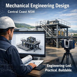
Mechanical Engineering Sydney Ports | Hamilton By Design

Sydney’s ports are critical infrastructure assets that support Australia’s import, export, logistics and maritime industries. Maintaining, upgrading and expanding port facilities requires practical mechanical engineering expertise capable of working within live operating environments while minimising disruption to ongoing operations.
Hamilton By Design provides mechanical engineering services for Sydney ports, marine terminals, bulk handling facilities, container terminals, wharves and associated industrial infrastructure. Our services support asset owners, port operators, contractors, manufacturers and maintenance teams requiring engineering solutions for materials handling systems, plant upgrades, structural modifications and brownfield developments.
Based in NSW and supporting projects throughout Sydney and regional Australia, we combine mechanical engineering, 3D LiDAR scanning, CAD design and engineering documentation to deliver practical, engineering-led outcomes.
Mechanical Engineering Services for Sydney Ports
Port facilities contain a wide range of mechanical systems that require ongoing maintenance, modification and improvement. Our engineering services are tailored to support both day-to-day operational requirements and major capital projects.
Typical services include:
- Mechanical engineering design
- Materials handling system design
- Conveyor upgrades and modifications
- Transfer chute design
- Structural steel support design
- Walkways, platforms and access systems
- Equipment relocation projects
- Plant upgrade engineering
- Mechanical drafting and documentation
- Reverse engineering of components
- Engineering inspections and assessments
- Brownfield infrastructure modifications
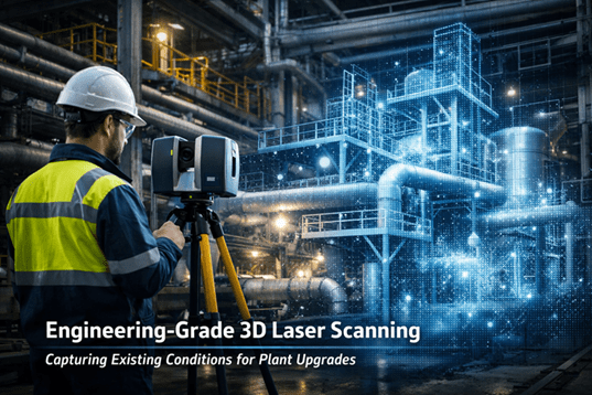
- 3D LiDAR scanning and reality capture
- Scan to CAD services
- As-built documentation
Our experience across industrial and mining environments provides practical insight into maintaining operational facilities while delivering engineering improvements.
Industries and Port Infrastructure We Support
Sydney ports contain a diverse range of infrastructure requiring specialised engineering support.
We regularly assist with:
Bulk Materials Handling Facilities
- Conveyor systems
- Transfer stations
- Ship loaders
- Hopper systems
- Stockpile conveyors
- Materials handling equipment
- Dust collection systems
Container Terminal Infrastructure
- Container handling equipment
- Mechanical support structures
- Equipment foundations
- Maintenance access systems
- Service platforms
Marine and Wharf Facilities
- Wharf structures
- Mechanical services infrastructure
- Pipework systems
- Utility installations
- Maintenance access platforms
Industrial Port Facilities
- Warehouses
- Processing plants
- Storage facilities
- Bulk liquid terminals
- Manufacturing facilities
- Logistics infrastructure
Engineering Design for Brownfield Port Facilities
Many Sydney port facilities have been operating for decades and contain limited or outdated engineering documentation.
Before modifications can commence, accurate information about existing conditions is essential.
Hamilton By Design specialises in engineering support for brownfield environments through:
- Existing condition surveys
- 3D LiDAR scanning
- Point cloud capture
- As-built modelling
- Scan to CAD conversion
- Equipment verification
- Clash detection
- Layout development
By capturing existing infrastructure before design begins, project risks can be significantly reduced while improving installation accuracy.
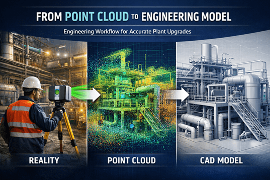
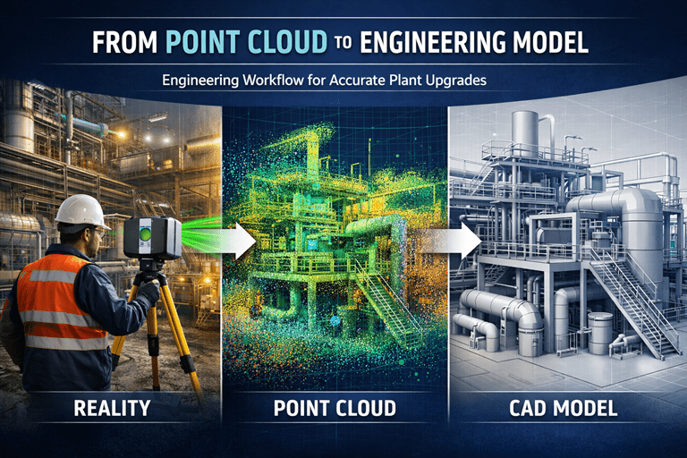
3D LiDAR Scanning and Mechanical Engineering
Modern engineering projects increasingly rely on accurate digital representations of existing facilities.
Our engineering team uses advanced 3D LiDAR scanning technology to capture:
- Conveyors
- Pipework
- Structural steel
- Transfer stations
- Ship loading infrastructure
- Equipment layouts
- Processing plant assets
- Mechanical services
The resulting point cloud data can be converted into engineering models and drawings used for:
- Upgrade design
- Retrofit projects
- Structural modifications
- Equipment replacements
- Maintenance planning
- Fabrication detailing
This approach reduces site rework, minimises clashes and improves project confidence.
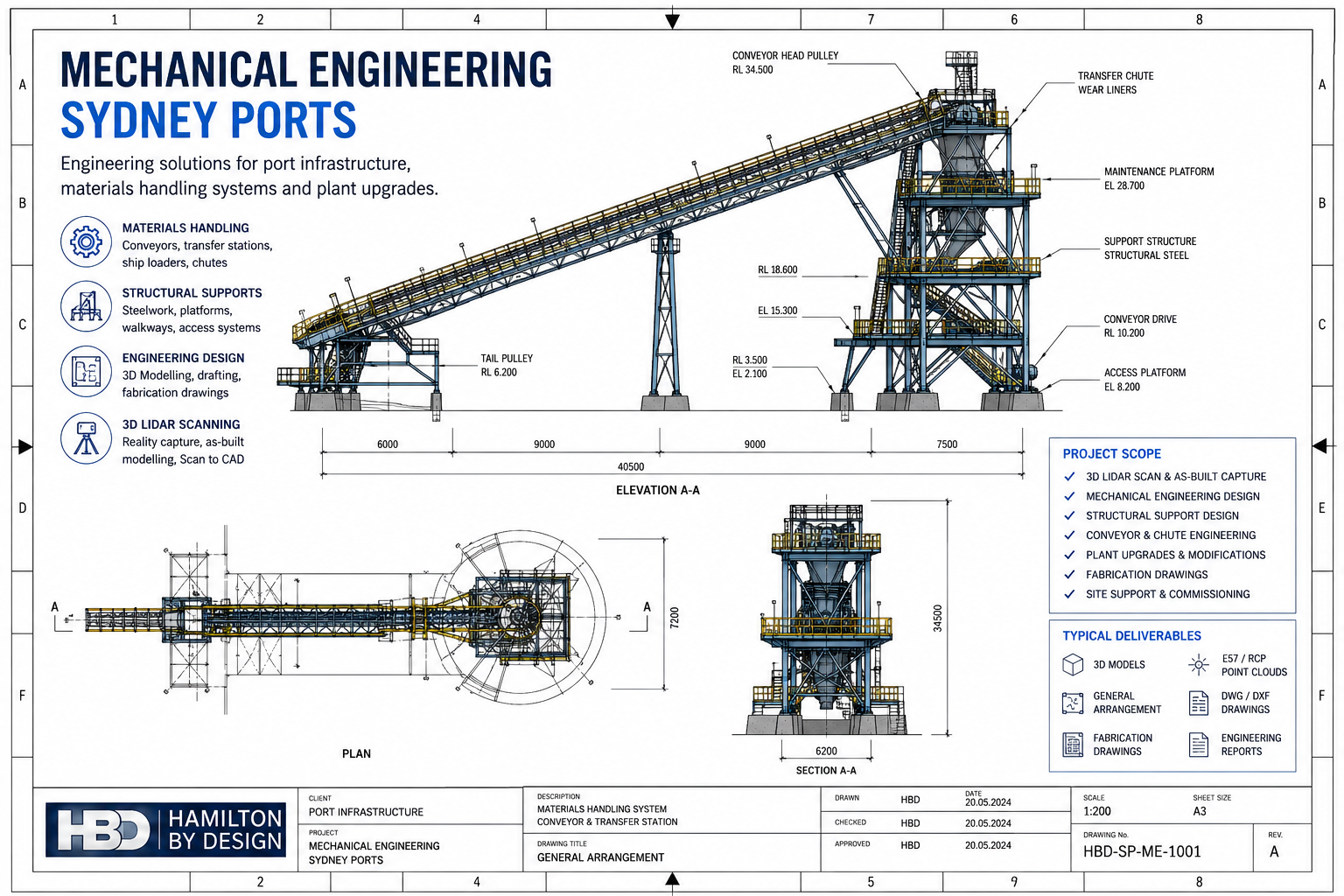
Materials Handling Engineering
Materials handling systems form the backbone of many port operations.
Our mechanical engineering services include:
Conveyor System Design
We provide engineering support for:
- New conveyor installations
- Conveyor upgrades
- Conveyor extensions
- Transfer point modifications
- Conveyor guarding
- Structural support systems
Transfer Chute Design
Efficient transfer chutes are critical for reducing wear, dust generation and material spillage.
Services include:
- Chute assessments
- Flow analysis
- Wear reduction solutions
- Maintenance improvements
- Upgrade concepts
Maintenance and Asset Improvement
Engineering support can assist with:
- Reliability improvements
- Equipment modifications
- Replacement strategies
- Asset life extension
- Shutdown planning
Mechanical Drafting and Documentation
Clear engineering documentation is essential for fabrication, installation and maintenance activities.
Deliverables may include:
- General arrangement drawings
- Mechanical layouts
- Fabrication drawings
- Assembly drawings
- Equipment models
- Structural details
- Site layouts
- Installation drawings
- CAD documentation
We work with commonly used engineering platforms including:
- SolidWorks
- Autodesk Inventor
- AutoCAD
- Autodesk ReCap
- Navisworks
Typical Deliverables
Depending on project requirements, deliverables may include:
- Mechanical engineering reports
- Concept designs
- Detailed engineering drawings
- General arrangement drawings
- CAD models
- SolidWorks models
- STEP files
- DWG files
- DXF files
- Point cloud data
- E57 files
- RCP and RCS files
- As-built documentation
- Equipment layouts
- Engineering recommendations
Our objective is to provide practical deliverables that can be directly used by project teams, fabricators and contractors.
Why Choose Hamilton By Design?
Hamilton By Design combines practical engineering experience with modern digital engineering technologies.
Our clients benefit from:
- Mechanical engineering expertise
- Engineering-led LiDAR scanning services
- Brownfield project experience
- Materials handling knowledge
- Practical design solutions
- Fast project mobilisation
- Australia-wide support
- Accurate engineering documentation
By combining engineering design with reality capture technologies, we help reduce project uncertainty while improving the quality of engineering outcomes.
Frequently Asked Questions
What mechanical engineering services do you provide for Sydney ports?
We provide engineering design, conveyor upgrades, materials handling engineering, plant modifications, structural support design, drafting and 3D LiDAR scanning services.
Can you scan existing port infrastructure before design work begins?
Yes. We provide engineering-grade 3D LiDAR scanning services to accurately capture existing facilities and create as-built models.
Do you work on operational port facilities?
Yes. Many projects are completed within live operational environments, allowing engineering work to be undertaken while minimising disruption.
Can you convert point clouds into CAD models?
Yes. Point cloud data can be converted into CAD drawings, SolidWorks models and engineering documentation.
Do you support conveyor upgrade projects?
Yes. We regularly assist with conveyor modifications, transfer chute improvements and materials handling upgrades.
Can you provide fabrication drawings?
Yes. Detailed fabrication and installation drawings can be produced where required.
What software do you use?
We commonly use SolidWorks, Autodesk Inventor, AutoCAD, Autodesk ReCap and Navisworks.
Do you provide Scan to CAD services?
Yes. We convert laser scan data into accurate engineering drawings and 3D models.
Do you work outside Sydney?
Yes. We support projects throughout NSW and Australia, including ports, mining operations, manufacturing facilities and industrial sites.
How do I obtain a quote?
Contact Hamilton By Design with your project requirements, available drawings and site information. We can then prepare a tailored proposal for your Sydney port engineering project.

Contact Hamilton By Design
If you require Mechanical Engineering Sydney Ports services, Hamilton By Design can assist with engineering design, plant upgrades, materials handling systems, 3D LiDAR scanning, Scan to CAD and engineering documentation.
Contact our team today to discuss your Sydney port infrastructure project and obtain a tailored engineering solution.
Talk to Us – Contact Us
Our clients: