Mechanical Engineering | 3D Scanning | 3D Modelling
Tag: 3D Laser Scanning
Explore articles and resources related to 3D laser scanning, including LiDAR scanning, point cloud capture, as-built documentation, reality capture, scan-to-CAD workflows, brownfield engineering applications, and engineering-grade digital modelling for industrial projects.
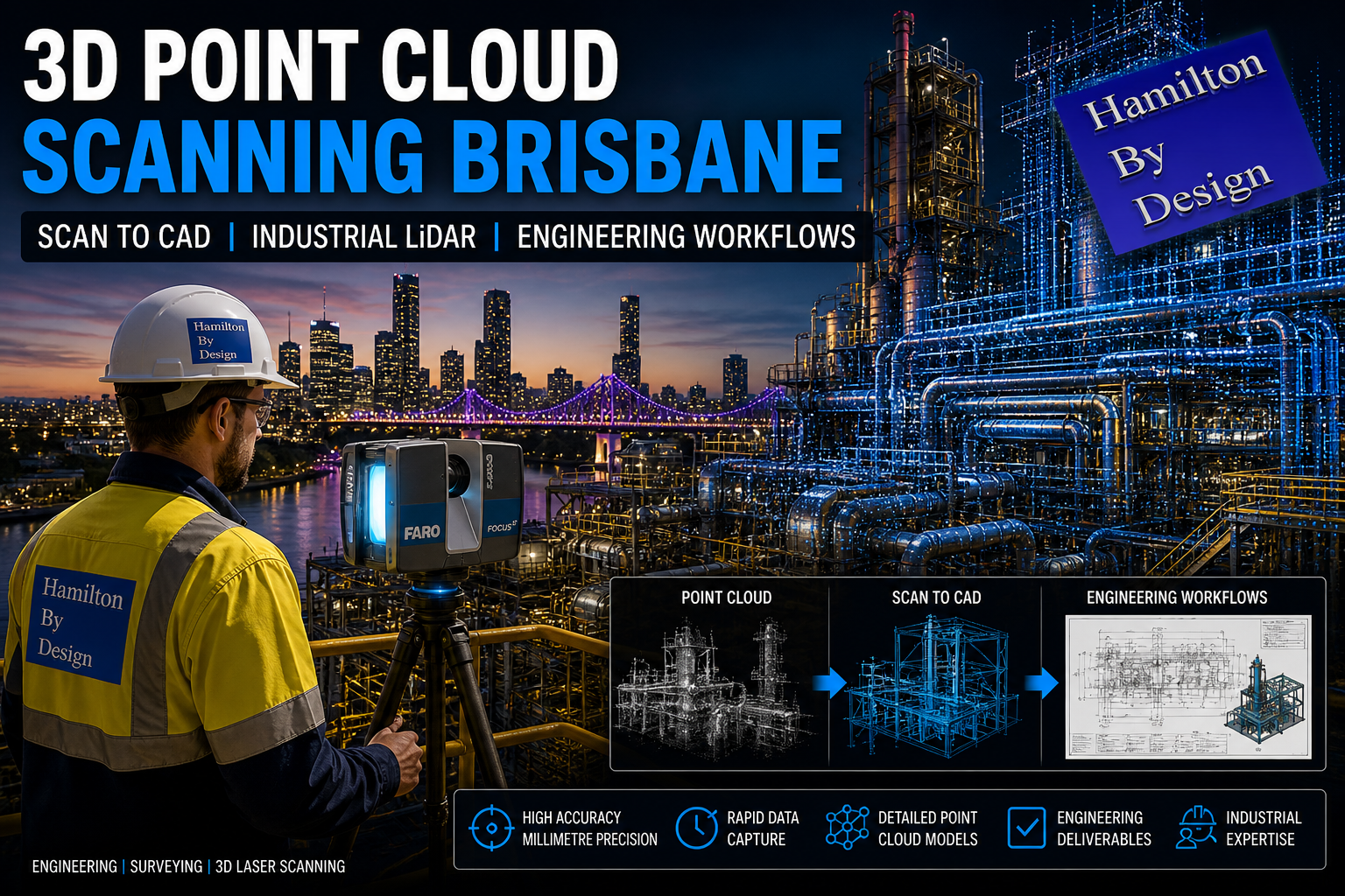
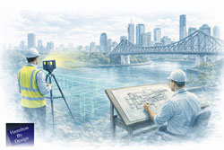
Accurate information is the foundation of every certified engineering decision. At Hamilton By Design, our 3D point cloud scanning in Brisbane delivers engineering-grade spatial data that engineers, designers, and asset owners can confidently rely on when certifying drawings, structures, plant upgrades, and industrial processes.
Engineers are legally and professionally responsible for the decisions they certify. This means the information used must be:
Accurate – true to physical reality
Traceable – derived from verifiable measurement
Repeatable – defensible if reviewed or audited
Fit for purpose – suitable for structural, mechanical, or process design
Consumer-grade scans, photos, or inferred measurements are not sufficient for certified outcomes.
Our engineering-led 3D point cloud scanning provides a measured digital record of what actually exists on site — not what drawings suggest, and not what assumptions fill the gaps.
What Is Engineering-Grade 3D Point Cloud Scanning?
A 3D point cloud is a dense collection of spatial data points captured using professional LiDAR scanners. Each point has a precise X, Y, Z coordinate in real-world space.
When captured correctly, this data allows engineers to:
Verify structural geometry
Measure clearances and tolerances
Identify clashes before construction
Confirm alignment, plumb, level, and deformation
Validate existing conditions for certification
Our Brisbane point cloud services are aligned with the same workflows used for certified mechanical, structural, and process engineering.
Supporting Certified Engineering Outcomes
1. Certified Drawings & Design
Engineers can only certify drawings if they trust the underlying measurements. Our scans support:
3D Point Cloud Modelling Melbourne | Engineering-Led LiDAR Models
Melbourne is home to some of Australia’s most complex industrial, infrastructure, and construction assets. From live manufacturing facilities and transport infrastructure to commercial and brownfield redevelopment projects, accurate understanding of existing conditions is critical.
Hamilton By Design provides engineering-grade 3D point cloud modelling services in Melbourne, supporting projects where precision, constructability, and accountability matter. Our workflows convert high-accuracy LiDAR scan data into usable engineering models that reflect what actually exists on site.
Engineering-Grade Point Cloud Modelling for Melbourne Projects
3D point cloud modelling is not simply about visualisation. For engineering, construction, and industrial projects in Melbourne, point clouds are used to:
Establish accurate existing conditions
Verify interfaces with existing assets
Reduce site rework and clashes
Support constructable design decisions
Enable confident fabrication and installation
Our modelling workflows are developed for engineering and delivery, not presentation.
From 3D Laser Scanning to Usable Engineering Models
All point cloud modelling begins with accurate data capture. Our Melbourne projects are supported by engineering-led 3D laser scanning, producing high-resolution point cloud datasets suitable for detailed modelling and analysis.
Once captured, point cloud data is processed, registered, and validated before being used as the foundation for downstream modelling.
Point Clouds as the Basis for As-Built Modelling
A common challenge on Melbourne projects is the lack of reliable as-built information. Drawings may be outdated, incomplete, or no longer reflect site conditions due to years of undocumented modifications.
Our point cloud modelling services directly address this issue by enabling:
Accurate as-built geometry derived from LiDAR data
Verification of steelwork, plant, and structural interfaces
Confident modelling of upgrades, retrofits, and extensions
For projects requiring documented existing conditions, point clouds are often converted into as-built drawings and models to support engineering, construction, and compliance requirements.
Applications of 3D Point Cloud Modelling in Melbourne
Our Melbourne point cloud modelling services are commonly used across:
Industrial and manufacturing facilities
Mechanical plant upgrades and retrofits
Infrastructure and utilities projects
Construction coordination and verification
Structural steel and access modifications
In these environments, point clouds provide a single, reliable source of truth that engineering teams can trust.
Integration with Engineering and Design Services
Point cloud modelling does not exist in isolation. At Hamilton By Design, point clouds are integrated into broader engineering workflows, supporting:
Mechanical and structural design
CAD modelling and documentation
Constructability review
Interface coordination
Asset information and lifecycle planning
Our point cloud services form part of a wider suite of engineering services delivered nationally, ensuring continuity from site capture through to design and documentation.
For Melbourne projects, the quality of a point cloud model directly affects downstream decisions. Our approach ensures that:
Data is captured with engineering intent
Modelling reflects real-world geometry and tolerances
Assumptions are minimised
Risks are identified early
Models can be relied upon for fabrication and site work
This engineering-owned approach reduces uncertainty and improves project outcomes, particularly on complex or live sites.
3D Point Cloud Modelling Services Across Melbourne
We support projects across metropolitan Melbourne and surrounding regions, including inner-city sites, industrial precincts, and large-scale infrastructure corridors. Whether supporting early project definition or detailed upgrade works, our point cloud modelling services are tailored to the realities of Melbourne’s built environment.
Discuss a 3D Point Cloud Modelling Project in Melbourne
If you require accurate, engineering-grade 3D point cloud modelling in Melbourne, Hamilton By Design can support your project from initial capture through to usable engineering models and documentation.
Contact our team to discuss how point cloud modelling can reduce risk and improve certainty on your next Melbourne project.
Preserving Today’s Information for Tomorrow’s Engineering Decisions
Buildings are long-life assets, but the information describing how they were actually built is often short-lived. Drawings become outdated, undocumented changes accumulate, and critical details disappear once concrete is poured or walls are closed.
Hamilton By Design provides engineering-grade 3D scanning and as-built BIM documentation across Greater Sydney, capturing what actually exists on site and converting it into reliable, decision-ready information that supports maintenance, compliance, refurbishment, sustainability upgrades, and long-term asset planning.
The data we collect today supports the engineering choices of tomorrow.
BIM Is Not a Concept Model — BIM Is As-Built Truth
BIM is often misunderstood as a design or visualisation tool. In practice, BIM only becomes valuable when it documents what was actually built, not what was originally intended.
This approach ensures that BIM outputs reflect real geometry, tolerances, and interfaces, remain useful years after construction, and support future engineering decisions.
Why Preserving As-Built Information Matters
Once a building enters service, change is constant. Services are rerouted during refurbishments and fit-outs, structural elements are modified, penetrations are added, and access conditions evolve.
Without a verified baseline, future engineers are forced to rely on assumptions.
By combining engineering-grade 3D laser scanning in Sydney with fit-for-purpose BIM documentation, we create a defensible digital record of the asset at a known point in time: https://www.hamiltonbydesign.com.au/3d-scanning-sydney/
This record becomes a reference that can be trusted long after drawings, photos, and site knowledge have disappeared.
Capturing Information Before It Becomes Hidden
Timing is critical.
3D scanning delivers the greatest long-term value when undertaken before concrete is poured, before walls or gyprock are fixed, before ceilings are closed, or before major refurbishments begin.
Once these elements are concealed, understanding what exists becomes invasive, interpretive, and costly. Early-stage reality capture creates a permanent digital record of conditions that would otherwise be lost forever.
Engineering-Led Scan-to-BIM
Accurate BIM requires more than software. Our workflows are grounded in engineering-led decision making and documentation, ensuring models are aligned with how assets actually perform and are modified over time: https://www.hamiltonbydesign.com.au/mechanical-engineering-services/
This approach ensures BIM outputs are fit for real engineering use, suitable for upgrades and modification, defensible for compliance and due diligence, and useful for fabrication, coordination, and access planning.
Supporting Commercial Buildings Across Sydney
Greater Sydney contains some of the most complex built environments in Australia, including high-density CBD assets, mixed-use developments, healthcare facilities, campuses, and strata buildings with shared services.
Preserved as-built information reduces uncertainty and allows design teams to plan works with confidence rather than assumptions.
Supporting Long-Life Industrial and Production Assets
Industrial and production facilities demand a higher level of certainty. Equipment upgrades, maintenance access, and future expansion depend on knowing exactly what exists.
In these environments, preserved information is a core risk-management tool.
Defects Investigations in 5–10 Years’ Time
Many building defects do not appear immediately. Water ingress, façade issues, slab movement, services failures, and vibration complaints often emerge years after construction.
A verified as-built scan and BIM baseline allows future engineers to compare conditions over time, identify hidden interfaces and penetrations, reduce destructive investigation, and diagnose issues more efficiently.
Without preserved data, defect investigations often start with uncertainty.
Post-Event Documentation
When an event occurs, whether seismic movement, impact damage, fire, or storm, rapid and accurate documentation becomes critical.
3D scanning after an event can capture a defensible condition record, support engineering assessment and triage, inform reinstatement scope, and assist insurers, owners, and regulators.
When paired with earlier scans, change becomes measurable rather than speculative.
Designing for Sustainability and User Experience Over the Next 10 Years
Sustainability upgrades fail when as-built reality is wrong.
Over the next decade, many Sydney assets will pursue energy upgrades, electrification pathways, improved HVAC performance, and better occupant comfort.
Scan-backed BIM supports these outcomes by ensuring plant rooms and services routes are understood, space constraints are known early, upgrades are coordinated before trades mobilise, and disruption is minimised.
Better information leads to better engineering choices and better outcomes for building users.
Engineering Decisions That Stand the Test of Time
The long-term consequences of poor documentation are well understood in engineering. Decisions made today echo years later.
Accurate as-built information underpins compliance, safety, and long-term asset performance. While 3D scanning and BIM are not mandated by a single Australian regulation, the intent of Australia’s building codes, standards, and information-management frameworks relies on reliable, traceable documentation of what has actually been constructed.
National Construction Code (NCC)
National Construction Code
The National Construction Code establishes performance requirements for structure, fire safety, access, health, amenity, and services. Although the NCC does not prescribe BIM or laser scanning, it assumes building work is supported by accurate and verifiable documentation. Scan-derived as-built BIM supports this intent by reducing reliance on assumptions during refurbishment, compliance reviews, and future upgrades.
ISO 19650 – Information Management Using BIM
ISO 19650
ISO 19650 defines best practice for managing information throughout the lifecycle of a built asset. Preserving today’s information for tomorrow’s engineering decisions aligns directly with this standard, particularly where as-built BIM is informed by reality capture and maintained as a lifecycle information resource.
Relevant Australian Standards
AS 1100 AS 3600 AS/NZS 3000 AS/NZS 3500 ISO 55000
These standards rely on accurate representation of geometry, services, and constructed conditions. Reality capture and as-built BIM support their intent by improving clarity, traceability, and long-term usability of engineering information.
Hamilton By Design does not claim that BIM itself guarantees compliance. Instead, our workflows support the intent of the NCC, ISO 19650, and relevant Australian Standards by improving the quality and reliability of building information used for engineering decisions.
Coverage Across Greater Sydney
Hamilton By Design provides 3D scanning and BIM documentation across Greater Sydney, including Sydney CBD, North Sydney, Chatswood, Parramatta, Macquarie Park, Ryde, Homebush, Alexandria, Mascot, Botany, Bankstown, Liverpool, Blacktown, Penrith, Castle Hill, Bella Vista, Brookvale, Manly, Hurstville, Sutherland, Cronulla, and surrounding precincts.
The Data We Collect Today Supports the Engineering Choices of Tomorrow
3D scanning and as-built BIM are not about creating a digital model for today’s project alone. They are about preserving truth before it disappears, reducing uncertainty years later, enabling sustainable upgrades, and supporting safer, smarter engineering decisions across the life of an asset.
That is the real value of BIM.
Our clients
Related Sydney Services
Hamilton By Design provides engineering-led 3D scanning, LiDAR scanning, mechanical engineering and digital engineering services throughout Sydney and Greater Sydney.
Explore our related Sydney services:
3D Scanning Sydney – Engineering-grade terrestrial laser scanning, as-built surveys and point cloud capture for industrial, infrastructure and commercial projects.
Reality Capture Sydney – High-accuracy reality capture, digital twins, asset documentation and engineering-grade site verification.
Scan to CAD Sydney – Convert point cloud data into AutoCAD, SolidWorks, Inventor and other engineering-ready CAD deliverables.
Point Cloud Modelling Sydney– Engineering-grade point cloud processing, clash detection, as-built verification and 3D modelling.
Mechanical Engineering Sydney – Mechanical design, plant upgrades, materials handling systems, conveyors, chutes, platforms and engineering support.
Structural Drafting Sydney– Structural steel drafting, fabrication drawings, GA drawings, workshop detailing and as-built documentation.
Hamilton By Design supports projects throughout Sydney CBD, Parramatta, Liverpool, Penrith, Blacktown, Chatswood, Alexandria, Mascot, Newcastle and the Central Coast.
3D Scanning Brisbane | Engineering-Led LiDAR & Risk Management
We are engineers. Let us manage your risk.
3D scanning is often treated as a visual exercise. In engineering, it is a measurement task. The difference matters.
At Hamilton By Design, 3D scanning in Brisbane is approached as an engineering activity, not just data capture. Our role is to ensure the information collected on site can be safely relied upon for design, fabrication, and installation — without rework, uncertainty, or guesswork.
What People Mean When They Say “3D Scanning”
When someone searches for 3D scanning Brisbane, they are usually trying to answer one question:
“How do I measure what already exists?”
That might be to:
Capture existing site conditions
Reduce uncertainty before fabrication
Avoid clashes or rework on site
The challenge is that not all scanning methods actually measure geometry.
3D Scanning in Brisbane – Typical Use Cases
Across Brisbane and South-East Queensland, 3D scanning is commonly used for:
Industrial plant upgrades and brownfield sites
As-built capture of steel, services, and structures
Fabrication completed off-site
Retrofit works with limited access
Shutdown and tie-in planning
For projects like these, scanning is typically carried out using engineering-grade laser scanning, not visual or consumer-grade tools. 3D Laser Scanning
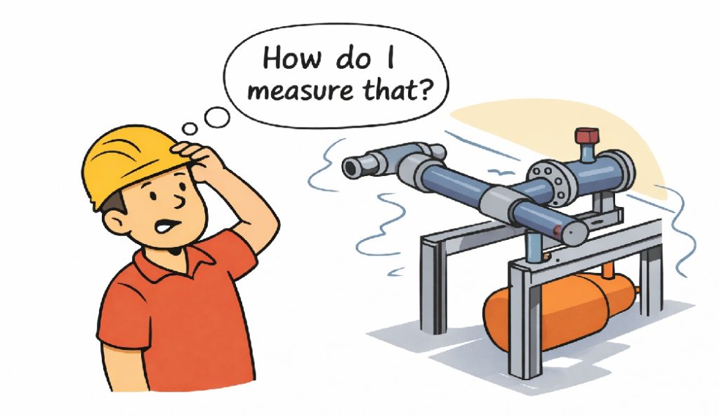
Scanning Is Not the Same as Measuring
(Simple cartoon here: character looking at an object asking “How do I measure that?”)
Scanning is not the same as measuring. In fabrication, we measure twice and cut once. With the right scanner, you only need to scan once.
Many scanning tools create models that look right but are based on inferred or smoothed geometry. For engineering, appearance is not enough — the data must be measurable and accurate.
Not All 3D Scanning Is the Same
There are different ways to “scan” a site, each producing very different outcomes:
Phone and visual scans Useful for reference and visualisation, but not suitable for engineering.
Photogrammetry Good for context and large areas, but geometry is inferred rather than directly measured.
Engineering-grade LiDAR scanning Uses direct distance measurement to generate a true 3D point cloud.
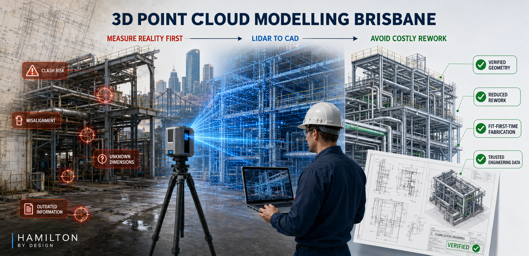
Measured scan data can then be converted into usable engineering information through point cloud modelling workflows. 3D Point Cloud Modelling Brisbane
When Engineering-Grade Scanning Is Required
Engineering-grade scanning is required when:
Steelwork must fit first time
Pipework or spools are fabricated off-site
Structural members must be verified
Clearances and clashes carry cost or safety risk
There is only one opportunity to access the site
In these cases, scan data is typically followed by a Scan-to-CAD process, where point clouds are converted into accurate 3D models and drawings. Scan to CAD Brisbane
Our Approach to 3D Scanning
Hamilton By Design treats scanning as part of a complete engineering workflow, not a standalone service.
Our approach includes:
Engineer-led scanning
Measurement-first mindset
Engineering-grade LiDAR equipment
Clear understanding of downstream use
By integrating scanning with mechanical engineering services, we maintain single-source accountability from site capture through to fabrication-ready deliverables. Mechanical Engineering Services
What Happens After the Scan
3D scanning is the starting point, not the end.
Accurate scan data supports:
3D CAD modelling
Fabrication and shop drawings
Structural verification
Clash detection and layout validation
Every downstream decision depends on the quality of the measurement captured at the start.
Talk to an Engineer Before You Scan
Many project issues begin with the wrong question:
“Can you scan this?”
The better question is:
“How do I measure this so it can be engineered?”
If you need 3D scanning in Brisbane that can safely support engineering and fabrication decisions, Hamilton By Design can help you get it right the first time.
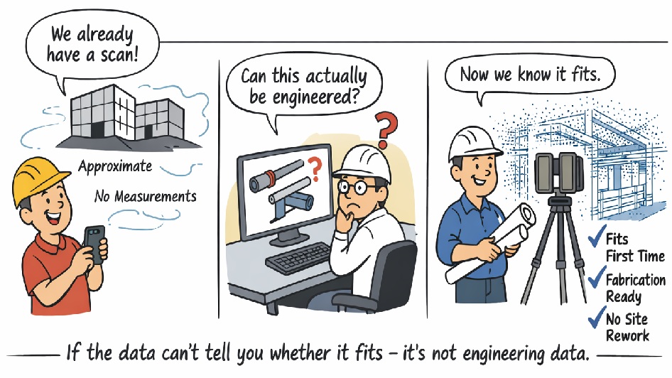
Modern engineering, fabrication, and asset upgrades increasingly rely on 3D point cloud data as the foundation for design decisions. However, not all “3D scans” produce data that is suitable for engineering-grade modelling.
At Hamilton By Design, we regularly encounter projects where scanning has already been undertaken, yet the data cannot be safely relied upon for structural checks, fabrication drawings, or fit-first-time installation. The reason is simple: many common scanning technologies do not generate a true, measurable 3D point cloud.
What Is a True Engineering 3D Point Cloud?
A true 3D point cloud consists of millions of directly measured XYZ coordinates, captured using survey-grade LiDAR technology. Each point represents a real, measured position in space, with known accuracy and traceable error.
This level of data is essential when:
Steelwork must fit without site modification
Pipe spools are fabricated off-site
Structural members must be verified
Clearances and clashes carry cost or safety risk
Visual models, meshes, or approximated surfaces may look correct, but without direct distance measurement and accuracy control, they cannot be relied upon for engineering.
Not All “3D Scans” Produce a Usable Point Cloud
The table below compares common capture methods against engineering-grade LiDAR scanning.
Engineering Data Comparison – 3D Capture Technologies
Criteria
Phone / App Scan
Photo-grammetry
Real-Estate / Visual Scanners
Engineering LiDAR (Hamilton By Design)
Direct distance measurement
❌ No
❌ No
⚠️ Limited
✅ Yes (time-of-flight)
True 3D point cloud output
⚠️ Low-density
❌ No (mesh only)
⚠️ Filtered
✅ Raw XYZ data
Global accuracy control
❌ None
❌ None
❌ None
✅ Survey-controlled
Typical usable accuracy
±20–50 mm
±10–30 mm
±10–20 mm
±1–2 mm
Consistent point density
❌ No
❌ No
❌ No
✅ Yes
Steel & reflective surfaces
❌ Poor
❌ Poor
⚠️ Limited
✅ Yes
Pipework & beam definition
❌ No
⚠️ Limited
❌ No
✅ Yes
Large industrial site capture
❌ No
⚠️ Limited
❌ No
✅ Yes
Registration error reporting
❌ No
❌ No
❌ No
✅ Yes
Suitable for fabrication drawings
❌ No
❌ No
❌ No
✅ Yes
Suitable for structural checks / FEA
❌ No
❌ No
❌ No
✅ Yes
Fit-first-time confidence
❌ No
❌ No
❌ No
✅ Yes
Why This Matters for Brisbane Projects
In Brisbane and across South-East Queensland, many projects involve:
Industrial plant upgrades
Infrastructure retrofits
Fabrication undertaken off-site
Tight shutdown windows
In these environments, millimetres matter. If a beam, pipe, or support cannot be accurately defined in the model, the risk of rework, delays, and site modification increases significantly.
Put simply:
If the data cannot reliably tell you whether something fits, clears, or carries load, it is not suitable for engineering.
Engineer-Led Point Cloud Modelling
Hamilton By Design uses engineering-grade terrestrial LiDAR scanners and an engineer-led workflow to ensure point cloud data is suitable for:
SolidWorks 3D modelling
Fabrication-ready drawings
Structural verification
Clash detection and layout validation
By controlling both data capture and modelling, we maintain single-source accountability — reducing risk and ensuring the model reflects reality.
From Scan to Shop Floor — Done Right
3D point cloud modelling is not about creating a visually impressive model. It is about creating a reliable digital representation of reality that engineers, fabricators, and contractors can trust.
If you are planning a project in Brisbane and need point cloud data that supports real engineering decisions, speak with Hamilton By Design before relying on consumer or visual-only scanning methods.
The Hunter Valley is one of Australia’s most technically complex industrial regions, combining power generation, mining, bulk materials handling, manufacturing, and logistics infrastructure within a tightly interconnected operational landscape. Projects in this environment frequently involve legacy assets, constrained access, and high consequences for design or construction error.
Reality capture in the Hunter Valley provides a structured, engineering-led method for documenting existing conditions using measured data rather than assumption-based interpretation. At Hamilton By Design, reality capture is applied as part of a broader engineering workflow—ensuring captured information directly supports design development, upgrade planning, fabrication coordination, and risk management.
Defining reality capture in an industrial context
Reality capture is the process of recording physical site conditions using spatially accurate technologies and converting that information into usable engineering references. In practical terms, this includes:
Engineering-grade laser scanning and LiDAR acquisition
Spatial data registration and validation
Interpretation of existing geometry in the context of mechanical and structural systems
Translation of measured data into drawings, models, and coordination outputs
The objective is not simply to visualise a site, but to create a reliable, defensible representation of existing conditions that can be used throughout the project lifecycle.
Why reality capture is critical in the Hunter Valley
Industrial facilities across the Hunter Valley often operate continuously while upgrades, modifications, and expansions are undertaken. Common project challenges include:
Brownfield environments with incomplete or outdated documentation
Complex interfaces between mechanical, structural, and civil systems
Fabrication occurring off-site with limited tolerance for dimensional error
Restricted access windows and safety-critical operating conditions
In these scenarios, traditional measurement approaches are often insufficient. Reality capture reduces uncertainty by establishing a single source of measured truth, enabling informed decisions before fabrication or installation begins.
Reality capture provides accurate documentation where legacy drawings no longer reflect actual site conditions. This baseline supports engineering assessments, upgrade feasibility studies, and staged project planning.
Plant upgrades and retrofit works
Measured spatial data allows new systems to be designed around existing plant, services, and structures, reducing clash risk and rework during installation.
Fabrication and construction coordination
Accurate capture of interfaces, clearances, and connection points improves alignment between design intent and fabricated components—particularly where fabrication is completed remotely.
Risk reduction and decision support
From an engineering governance perspective, reality capture improves information quality, reduces assumptions, and supports more defensible technical decisions.
Engineering-led reality capture methodology
Hamilton By Design approaches reality capture as a project-specific engineering activity, not a generic surveying exercise.
1. Scope definition aligned to outcomes
Capture scope is defined based on how the data will be used—design development, drafting, verification, or coordination—ensuring the level of detail and accuracy is appropriate.
2. Structured site data acquisition
Capture activities are planned to manage occlusion, access limitations, and operational constraints commonly encountered on Hunter Valley industrial sites.
3. Data validation and preparation
Captured datasets are reviewed, registered, and structured so they can be confidently used for engineering interpretation rather than remaining as raw data.
4. Engineering-ready deliverables
Where required, reality capture outputs are converted into:
As-built drawings
General arrangement layouts
Reference models for coordination
Documentation suitable for engineering review and approvals
Relationship between reality capture and laser scanning
While laser scanning and LiDAR are commonly used tools within reality capture, the distinction lies in how the data is applied. Laser scanning provides the measurements; reality capture ensures those measurements are contextualised, validated, and integrated into engineering workflows.
This distinction is particularly important in industrial regions such as the Hunter Valley, where inaccurate interpretation of spatial data can have significant cost and safety implications.
Asset owners and operators gain confidence in upgrade planning
Engineers work from verified existing-condition data
Fabricators receive clearer interface definitions
Project teams reduce site disruption and variation risk
From a systems engineering perspective, this represents an improvement in information reliability and traceability—both key drivers of project performance.
Regional capability and service coverage
Hamilton By Design services the Hunter Valley as part of its broader NSW engineering and reality capture capability, supporting projects across industrial, energy, and infrastructure sectors.
To provide the best experiences, we use technologies like cookies to store and/or access device information. Consenting to these technologies will allow us to process data such as browsing behaviour or unique IDs on this site. Not consenting or withdrawing consent, may adversely affect certain features and functions.
Functional
Always active
The technical storage or access is strictly necessary for the legitimate purpose of enabling the use of a specific service explicitly requested by the subscriber or user, or for the sole purpose of carrying out the transmission of a communication over an electronic communications network.
Preferences
The technical storage or access is necessary for the legitimate purpose of storing preferences that are not requested by the subscriber or user.
Statistics
The technical storage or access that is used exclusively for statistical purposes.The technical storage or access that is used exclusively for anonymous statistical purposes. Without a subpoena, voluntary compliance on the part of your Internet Service Provider, or additional records from a third party, information stored or retrieved for this purpose alone cannot usually be used to identify you.
Marketing
The technical storage or access is required to create user profiles to send advertising, or to track the user on a website or across several websites for similar marketing purposes.