Mechanical Engineering | 3D Scanning | 3D Modelling
Tag: 3d CAD Modelling
3D CAD modelling services supporting engineering design, fabrication and retrofit projects, including scan-to-CAD modelling from point clouds, as-built documentation and interface modelling for mechanical and structural systems.
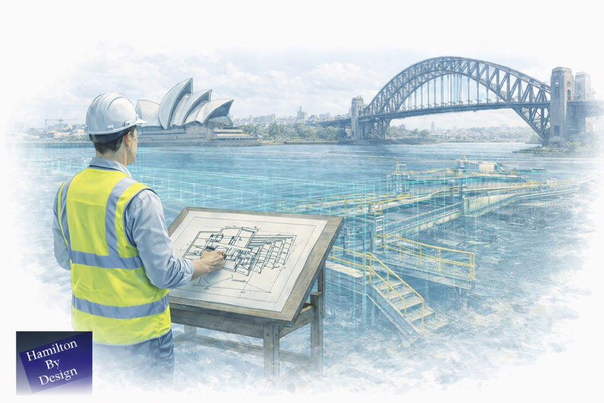
Hamilton By Design delivers 3D engineering services in Melbourne that enable designers and engineers to develop solutions based on measured reality, not assumptions.
By combining engineering-grade laser scanning, point cloud modelling, and coordinated 3D CAD environments, we support better decision-making across construction, infrastructure, industrial, and asset-upgrade projects throughout Melbourne and Victoria.
Why 3D Engineering Changes Design Outcomes
Traditional design workflows often rely on:
Incomplete as-built drawings
Historical documentation of unknown accuracy
Assumptions about alignment, levels, and clearances
A 3D engineering model replaces uncertainty with verified spatial data.
When designers work inside a coordinated 3D environment, they gain:
Full visibility of existing conditions
Early identification of constraints
Clear understanding of interfaces
Confidence that the proposed design can actually be built
This is especially critical for brownfield sites, upgrades, and staged construction works common across Melbourne.
3D Models Enable Better Scope-Driven Design
Every engineering project is governed by scope — what is changing, what remains, and what must interface correctly.
A 3D model allows designers to:
Test multiple design options against real constraints
Validate that scope assumptions are correct
Adjust layouts before drawings are issued
Reduce downstream RFIs and site rework
Instead of designing to drawings, teams design to reality.
Laser Scanning as the Foundation of 3D Engineering
Accurate 3D engineering begins with accurate capture.
Our Melbourne workflows are built on professional LiDAR scanning that produces dense, structured point cloud data suitable for engineering use.
A 3D engineering model allows designers to answer critical questions early:
Will it fit?
Can it be installed?
Does it clash with existing services?
Is the assumed geometry actually correcting?
Can this be built safely and efficiently?
By resolving these questions digitally, engineering teams reduce uncertainty and improve outcomes across the entire project lifecycle.
Why Hamilton By Design in Melbourne
Engineering-led scanning and modelling
3D models built from verified site data
Strong integration between capture, CAD, and engineering review
Experience with brownfield, retrofit, and complex sites
Models that support real design decisions — not just visuals
We don’t just create 3D models. We create engineering environments that designers can trust.
Discuss Your 3D Engineering Requirements in Melbourne
If your project requires accurate information to support design decisions, Hamilton By Design can assist with 3D engineering in Melbourne from initial capture through to coordinated model delivery.
Contact us to discuss your scope and design requirements.
Hamilton By Design provides engineering-led 3D CAD design services in Sydney, supporting construction, infrastructure, manufacturing, and industrial projects where accuracy, coordination, and certifiable outcomes matter.
Our Sydney-based 3D CAD services are built on measured reality, using professional laser scanning and point cloud data to ensure that CAD models reflect what truly exists on site — not assumptions taken from legacy drawings or incomplete information.
This approach reduces risk, prevents rework, and supports engineers, builders, and asset owners in delivering reliable outcomes.
Engineering-Grade 3D CAD Design
A 3D CAD designer working on engineering projects must do more than “draw in 3D”. Engineers rely on CAD models to:
Produce certified drawings
Verify interfaces and tolerances
Coordinate structural and mechanical elements
Support construction sequencing and installation
Reduce clashes and site modifications
Our CAD designers work as part of an integrated engineering workflow, aligned with how designs are reviewed, approved, and built in Sydney.
CAD Built from Real-World Data
Where projects involve existing buildings, plant, or infrastructure, our CAD models are developed directly from LiDAR scan data, ensuring dimensional accuracy and spatial confidence.
Our 3D CAD designers regularly support Sydney construction and engineering teams by delivering models suitable for coordination, shop detailing, and constructability review.
Strong integration with laser scanning and point clouds
Experience across construction, industrial, and infrastructure projects
Models suitable for certified and reviewed engineering outcomes
We do not offer generic drafting. We provide 3D CAD design that engineers can rely on.
Talk to a Sydney-Based 3D CAD Designer
If your project requires accurate CAD models built from real site conditions, Hamilton By Design can support your Sydney project from scan through to CAD delivery.
📩 Contact us to discuss your 3D CAD designer requirements in Sydney.
Related Sydney Services
Hamilton By Design provides engineering-led 3D scanning, LiDAR scanning, mechanical engineering and digital engineering services throughout Sydney and Greater Sydney.
Explore our related Sydney services:
3D Scanning Sydney – Engineering-grade terrestrial laser scanning, as-built surveys and point cloud capture for industrial, infrastructure and commercial projects.
Reality Capture Sydney – High-accuracy reality capture, digital twins, asset documentation and engineering-grade site verification.
Scan to CAD Sydney – Convert point cloud data into AutoCAD, SolidWorks, Inventor and other engineering-ready CAD deliverables.
Point Cloud Modelling Sydney– Engineering-grade point cloud processing, clash detection, as-built verification and 3D modelling.
Mechanical Engineering Sydney – Mechanical design, plant upgrades, materials handling systems, conveyors, chutes, platforms and engineering support.
Structural Drafting Sydney– Structural steel drafting, fabrication drawings, GA drawings, workshop detailing and as-built documentation.
Hamilton By Design supports projects throughout Sydney CBD, Parramatta, Liverpool, Penrith, Blacktown, Chatswood, Alexandria, Mascot, Newcastle and the Central Coast.
Why Accuracy, Precision, and Calibration Matter for Engineering Outcomes
When 3D LiDAR scanning is used for engineering, fabrication, or certification, the most important question is not how detailed the point cloud looks, but whether the measurements can be trusted.
This is where AS ISO 5725 — Accuracy and Precision of Measurement becomes relevant. While AS ISO 5725 is not written specifically for LiDAR scanners, it defines the principles that determine whether any measurement system is suitable for engineering use.
In practical terms, AS ISO 5725 separates data that can support engineering decisions from data that is visually convincing but technically unreliable.
What AS ISO 5725 Covers
AS ISO 5725 defines how measurement systems should be evaluated in terms of:
Accuracy
Precision
Repeatability
Reproducibility
Measurement uncertainty
These principles apply directly to 3D LiDAR scanning because a LiDAR scanner is, at its core, a measurement instrument. When scanning data is used to inform design, fabrication, or certification, the expectations set by AS ISO 5725 apply regardless of scanner brand or software.
This is why engineering-grade 3D LiDAR scanning requires more than simply capturing a dense point cloud. It requires controlled measurement, understood uncertainty, and validated outputs, as delivered through engineering-grade 3D laser scanning workflows: https://www.hamiltonbydesign.com.au/home/engineering-services/3d-laser-scanning/
Accuracy vs Precision in LiDAR Scanning
AS ISO 5725 makes a clear distinction between accuracy and precision, a distinction that is often misunderstood in reality capture.
Accuracy describes how close a measurement is to the true value. Precision describes how consistently the same measurement can be repeated.
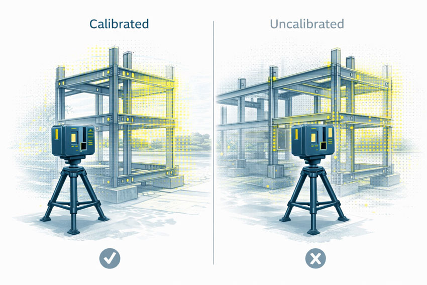
A LiDAR scan can appear highly precise, with clean and consistent geometry, while still being inaccurate if the scanner is miscalibrated or poorly controlled. In engineering terms, repeatable errors are still errors.
For engineering and fabrication, both accuracy and precision are required.
The Role of Calibration
Calibration ensures that a scanner’s distance and angular measurements align with known reference values. Without calibration, a LiDAR scanner may still operate normally and still produce visually impressive results, but the measurements no longer have a known or defensible level of uncertainty.
Calibration directly affects:
Distance measurement
Angular accuracy
Alignment between internal sensors
Registration between multiple scans
AS ISO 5725 does not prescribe how calibration must be performed, but it does establish the expectation that measurement uncertainty is understood and controlled.
What Happens When Scanning Is Not Calibrated
When LiDAR scanning is not properly calibrated or verified, errors propagate into every downstream deliverable.
Common outcomes include:
Fabricated steelwork that does not fit on site
Bolt holes and connection points outside tolerance
Frames requiring on-site modification or rework
Assumed clearances that do not exist in reality
Delays or challenges during engineering sign-off
These issues are often discovered late in a project, where the cost of correction is highest. The root cause is frequently measurement error introduced at the scanning stage, not fabrication quality.
One of the most significant risks in unverified scanning workflows is that errors are often small enough to go unnoticed early.
A few millimetres of error at the scanning stage can compound into much larger discrepancies once geometry is modelled, detailed, and fabricated. Across multiple interfaces, these small deviations can lead to misalignment, rework, or compromised installation quality.
For fit-first-time fabrication, this risk is unacceptable.
Engineering Responsibility and Certification Risk
When LiDAR data is used to support engineering decisions, responsibility does not sit with the scanner or the software. It sits with the engineer relying on the data.
If measurements cannot be demonstrated as accurate, repeatable, and appropriately controlled, they are not suitable to support engineering sign-off. This is particularly relevant where scanning data contributes to certification outcomes, where accountability and defensibility are essential.
AS ISO 5725 is not about paperwork or compliance for its own sake. It provides the framework that ensures measurement data used for engineering decisions is fit for purpose.
When LiDAR scanning is undertaken with accuracy, precision, and calibration treated seriously, it becomes a powerful engineering tool. When these principles are ignored, scanning becomes a source of hidden risk that only emerges when it is too late to correct cheaply.
Final Thought
3D LiDAR scanning is only as reliable as the measurement discipline behind it.
AS ISO 5725 provides the foundation for understanding whether scanning data can be trusted. In engineering, fabrication, and certification contexts, that trust is not optional — it is essential.
The Hunter Valley is one of Australia’s most technically complex industrial regions, combining power generation, mining, bulk materials handling, manufacturing, and logistics infrastructure within a tightly interconnected operational landscape. Projects in this environment frequently involve legacy assets, constrained access, and high consequences for design or construction error.
Reality capture in the Hunter Valley provides a structured, engineering-led method for documenting existing conditions using measured data rather than assumption-based interpretation. At Hamilton By Design, reality capture is applied as part of a broader engineering workflow—ensuring captured information directly supports design development, upgrade planning, fabrication coordination, and risk management.
Defining reality capture in an industrial context
Reality capture is the process of recording physical site conditions using spatially accurate technologies and converting that information into usable engineering references. In practical terms, this includes:
Engineering-grade laser scanning and LiDAR acquisition
Spatial data registration and validation
Interpretation of existing geometry in the context of mechanical and structural systems
Translation of measured data into drawings, models, and coordination outputs
The objective is not simply to visualise a site, but to create a reliable, defensible representation of existing conditions that can be used throughout the project lifecycle.
Why reality capture is critical in the Hunter Valley
Industrial facilities across the Hunter Valley often operate continuously while upgrades, modifications, and expansions are undertaken. Common project challenges include:
Brownfield environments with incomplete or outdated documentation
Complex interfaces between mechanical, structural, and civil systems
Fabrication occurring off-site with limited tolerance for dimensional error
Restricted access windows and safety-critical operating conditions
In these scenarios, traditional measurement approaches are often insufficient. Reality capture reduces uncertainty by establishing a single source of measured truth, enabling informed decisions before fabrication or installation begins.
Reality capture provides accurate documentation where legacy drawings no longer reflect actual site conditions. This baseline supports engineering assessments, upgrade feasibility studies, and staged project planning.
Plant upgrades and retrofit works
Measured spatial data allows new systems to be designed around existing plant, services, and structures, reducing clash risk and rework during installation.
Fabrication and construction coordination
Accurate capture of interfaces, clearances, and connection points improves alignment between design intent and fabricated components—particularly where fabrication is completed remotely.
Risk reduction and decision support
From an engineering governance perspective, reality capture improves information quality, reduces assumptions, and supports more defensible technical decisions.
Engineering-led reality capture methodology
Hamilton By Design approaches reality capture as a project-specific engineering activity, not a generic surveying exercise.
1. Scope definition aligned to outcomes
Capture scope is defined based on how the data will be used—design development, drafting, verification, or coordination—ensuring the level of detail and accuracy is appropriate.
2. Structured site data acquisition
Capture activities are planned to manage occlusion, access limitations, and operational constraints commonly encountered on Hunter Valley industrial sites.
3. Data validation and preparation
Captured datasets are reviewed, registered, and structured so they can be confidently used for engineering interpretation rather than remaining as raw data.
4. Engineering-ready deliverables
Where required, reality capture outputs are converted into:
As-built drawings
General arrangement layouts
Reference models for coordination
Documentation suitable for engineering review and approvals
Relationship between reality capture and laser scanning
While laser scanning and LiDAR are commonly used tools within reality capture, the distinction lies in how the data is applied. Laser scanning provides the measurements; reality capture ensures those measurements are contextualised, validated, and integrated into engineering workflows.
This distinction is particularly important in industrial regions such as the Hunter Valley, where inaccurate interpretation of spatial data can have significant cost and safety implications.
Asset owners and operators gain confidence in upgrade planning
Engineers work from verified existing-condition data
Fabricators receive clearer interface definitions
Project teams reduce site disruption and variation risk
From a systems engineering perspective, this represents an improvement in information reliability and traceability—both key drivers of project performance.
Regional capability and service coverage
Hamilton By Design services the Hunter Valley as part of its broader NSW engineering and reality capture capability, supporting projects across industrial, energy, and infrastructure sectors.
In complex engineering environments, success is rarely determined by a single calculation or drawing. It is determined by clarity—clarity of information, clarity of intent, and clarity across every handover point between site, engineer, fabricator, and installer.
Hamilton By Design was created around this idea.
Across mining, heavy industry, infrastructure, and complex buildings, projects increasingly fail not because engineers lack capability, but because teams are working from incomplete, inconsistent, or unreliable information. Assumptions creep in. Measurements are approximated. Old drawings are trusted when they should not be. By the time fabrication or installation begins, risk has already been locked into the project.
Hamilton By Design approaches engineering differently. By combining engineer-led 3D laser scanning, SolidWorks-based mechanical design, and clear, practical data sharing, we reduce uncertainty at the very start of a project—and that single shift changes everything that follows.
Engineering begins with reality, not assumptions
Every project starts with an existing environment. Whether it is a CHPP in the Bowen Basin, a brownfield processing plant, a congested industrial building, or a live infrastructure asset, the reality on site is often more complex than any drawing suggests.
Hamilton By Design begins with capturing reality as it actually exists.
Using high-accuracy 3D laser scanning, site conditions are recorded in full context: structure, equipment, services, clearances, and access constraints. This is not about producing pretty visuals—it is about creating a measurable, defensible digital reference that engineers can trust.
Unlike traditional measurement methods, laser scanning:
Captures millions of data points per second
Records geometry that is difficult or unsafe to measure manually
Preserves site information long after access windows close
Eliminates reliance on assumptions and partial measurements
For engineering teams, this changes the starting point of the project from “what we think is there” to “what we know is there.”
Why the FARO Focus S70 fits Hamilton By Design’s workflow
4
Hamilton By Design uses the FARO Focus S70 laser scanner because it strikes the right balance between accuracy, portability, and ease of use—qualities that matter in live industrial environments.
The Focus S70 is particularly well suited to:
Brownfield industrial sites
Mining and materials-handling plants
Buildings with tight access or active operations
Remote locations where speed and reliability matter
From a practical engineering perspective, its ease of deployment is critical. Scans can be completed quickly, often without disrupting operations, and without the need for complex setup or prolonged site occupation. This means:
Shorter site visits
Reduced exposure to operational risk
More flexibility around shutdown or access windows
Just as importantly, the data produced is clean, consistent, and immediately usable within downstream engineering workflows.
At Hamilton By Design, scanning is not outsourced or treated as a separate discipline. The same engineers who design the solution are involved in planning the scan, understanding what information matters, and verifying that the captured data is fit for purpose.
This engineer-led approach is one of the quiet but critical advantages that underpins project success.
Turning point clouds into engineering intelligence
Raw point clouds are powerful—but only if they are translated into meaningful engineering information.
This is where Hamilton By Design’s use of SolidWorks becomes central to our workflow.
SolidWorks provides a flexible, parametric modelling environment that allows scanned data to be transformed into:
Accurate 3D mechanical models
Structural steel frameworks
Equipment layouts
Platforms, guards, chutes, and pipework
Assemblies designed specifically for fabrication and installation
By importing and referencing point clouds directly within SolidWorks, engineers are no longer designing in isolation. Every model is built in context, anchored to the real geometry of the site.
This approach delivers several key advantages:
Components fit the first time
Clearances are verified early
Interfaces with existing assets are fully understood
Installation sequencing can be considered during design
Rather than working around uncertainty, engineers are free to focus on optimisation, constructability, and safety.
SolidWorks as a collaboration platform, not just a design tool
One of the most underestimated strengths of SolidWorks is how well it supports collaboration and communication across project teams.
At Hamilton By Design, SolidWorks models are not treated as internal artefacts. They are shared, reviewed, and used as communication tools.
Through native files, neutral formats, and lightweight viewing options:
Fabricators can interrogate geometry before cutting steel
Site teams can visualise assemblies before installation
Clients can understand scope and interfaces without reading complex drawings
Engineers can identify risks long before they appear on site
This transparency dramatically reduces misinterpretation. When everyone is looking at the same model—derived from the same scan—alignment improves naturally.
The result is fewer RFIs, fewer site surprises, and a smoother transition from design to construction.
Fabrication-ready outcomes, not theoretical models
Hamilton By Design places a strong emphasis on fabrication-ready deliverables.
Because models are developed with manufacturing in mind, downstream drawings are clearer, more consistent, and easier to build from. This includes:
Clear general arrangement drawings
Detailed part and assembly drawings
Logical BOMs aligned to procurement
Realistic tolerances based on site conditions
Fabricators appreciate drawings that reflect how things are actually built—not just how they look on screen. By grounding design in scan data and modelling within SolidWorks, Hamilton By Design produces outputs that align closely with workshop reality.
This reduces rework in the shop and stress during shutdowns, where time pressure is highest.
Technology alone does not deliver project success. The real differentiator is how information is shared.
Hamilton By Design places significant emphasis on making data:
Accessible
Understandable
Reusable
Point clouds, models, drawings, and supporting data are structured so they can be:
Revisited for future projects
Used by different stakeholders
Built upon rather than recreated
This is particularly valuable in long-life industrial assets, where today’s modification becomes tomorrow’s interface.
By maintaining continuity of data across projects, clients build a digital asset—not just a set of drawings. Over time, this reduces engineering cost, shortens project timelines, and increases confidence in future upgrades.
Ease of use drives adoption and value
One of the reasons the FARO Focus S70 and SolidWorks work so well together is their ease of use relative to the value they deliver.
Ease of use matters because:
It shortens learning curves
It reduces reliance on niche specialists
It allows engineers to stay focused on engineering, not software complexity
At Hamilton By Design, tools are selected not because they are fashionable, but because they support repeatable, reliable outcomes.
Scanning workflows are streamlined. Modelling practices are consistent. File structures are logical. This discipline ensures that projects scale smoothly, whether they involve a small retrofit or a major plant upgrade.
Reducing risk where it matters most
In industrial and mining projects, risk concentrates at interfaces:
New steel to old steel
New equipment to existing plant
Design intent to site execution
Hamilton By Design’s integrated workflow reduces risk at these interfaces by ensuring:
Geometry is verified early
Interfaces are modelled, not guessed
Decisions are made with full context
This approach shifts risk out of the shutdown window and into the design phase—where it is cheaper and safer to manage.
A philosophy built around accountability
What truly differentiates Hamilton By Design is not just technology, but ownership.
The same team is responsible for:
Capturing site data
Interpreting it
Designing the solution
Producing fabrication-ready outputs
There is no fragmentation between disciplines, no handover gaps where responsibility becomes unclear. This single-source accountability builds trust with clients, fabricators, and site teams alike.
The compound effect of doing it right
When accurate data, SolidWorks-based design, and clear information sharing come together, the benefits compound:
Fewer site visits
Shorter design cycles
More confident fabrication
Smoother installations
Better long-term asset knowledge
Over time, this approach changes how projects are delivered. Engineering becomes proactive rather than reactive. Problems are solved digitally instead of on site. Teams collaborate instead of firefighting.
Engineering for real-world success
Hamilton By Design’s workflow is not built around theory. It is built around what actually happens on site.
By grounding every project in reality through laser scanning, translating that reality into SolidWorks models, and sharing information clearly across all stakeholders, Hamilton By Design helps projects succeed where it matters most: in fabrication shops, during shutdowns, and on live sites.
In an industry where uncertainty is expensive and time is unforgiving, clarity becomes the most valuable engineering output of all.
That is the philosophy behind Hamilton By Design—and the reason our approach continues to deliver consistent, practical success across complex engineering projects.
Orange is one of Australia’s most distinctive regional cities. Set high on the Central Tablelands, it combines a cool-climate environment with major health, education, agriculture, infrastructure, and mining-services activity. Engineering in Orange is shaped by altitude, frost, diverse industries, and a mix of modern and legacy assets—making accuracy, coordination, and practical design essential.
Hamilton By Design supports projects in and around Orange by combining 3D LiDAR laser scanning, mechanical and structural engineering, 3D CAD modelling, FEA, and fabrication-ready drafting. Our approach focuses on capturing real site conditions and turning them into buildable, engineering-approved outcomes.
Engineering challenges in a high-altitude regional city
Unlike many inland centres, Orange’s elevation brings colder temperatures, frost, and greater thermal movement. At the same time, the city supports critical assets such as hospitals, utilities, agricultural processing facilities, and infrastructure that must remain operational.
Engineering teams commonly deal with:
Brownfield sites with assets added over decades
Incomplete or outdated drawings
Tight staging requirements around live facilities
A need for conservative, reliable design
In this environment, assumptions introduce risk. Accurate as-built data is the foundation of successful projects.
3D Laser Scanning for Orange projects
Hamilton By Design uses high-accuracy 3D Laser Scanning to capture the true as-built condition of sites across Orange and the Central Tablelands. Laser scanning records millions of precise measurements, creating a detailed digital record of buildings, plant, structures, and surrounding interfaces.
3D laser scanning is particularly valuable in Orange for:
Health, education, and public infrastructure upgrades
Industrial and agricultural processing facilities
Mining-support and utilities assets
Sites where drawings no longer reflect reality
Scanning is typically completed during short, controlled site visits, minimising disruption while delivering data that can be relied on throughout the project.
Turning scan data into accurate 3D models
Once scanning is complete, the data is processed and converted into detailed 3D CAD Modelling. These models represent what actually exists on site—not what historic documentation suggests.
For Orange projects, scan-based 3D modelling supports:
Mechanical upgrades and equipment replacements
Structural additions such as platforms, supports, and access ways
Integration of new assets into existing facilities
Long-term digital records for future maintenance and expansion
Accurate models reduce uncertainty and allow design decisions to be made early and with confidence.
Mechanical and structural engineering built on real conditions
Engineering in Orange often involves coordinating multiple disciplines across constrained or operational sites. Working from scan-derived models allows engineers to:
Understand existing load paths and constraints
Check clearances and access early in the design
Coordinate mechanical and structural elements in a single environment
This leads to designs that are practical, buildable, and aligned with how assets are actually used—particularly important in a climate-affected region.
FEA to support performance and compliance
Where performance, safety, or compliance is critical, Hamilton By Design applies FEA Capabilities to support engineering decisions.
Finite Element Analysis is commonly used to:
Check structural capacity under operational and environmental loads
Assess modifications to existing steel and concrete
Review fatigue, vibration, and deflection
Support engineering approval and sign-off
Using FEA on scan-based geometry provides confidence that designs will perform as intended in real operating conditions.
Easy-to-build fabrication drawings with engineering approval
Clear documentation is essential for efficient construction—particularly in regional locations where rework can be costly. Hamilton By Design produces fabrication-ready Drafting directly from coordinated 3D models.
Typical deliverables include:
General arrangement and detail drawings
Fabrication and installation drawings
Engineering-reviewed and approval-ready documentation
This focus on clarity and constructability helps fabricators and contractors build accurately the first time.
Reducing risk through digital engineering
By capturing site conditions once and completing the majority of engineering off site, projects in Orange benefit from:
Reduced site visits and travel costs
Improved safety outcomes
Better coordination before fabrication
Fewer surprises during installation
This approach aligns well with Orange’s role as a regional hub supporting diverse industries across central NSW.
Supporting Orange with practical, buildable engineering
Orange’s strength lies in its balance—health, agriculture, infrastructure, mining services, and community all intersect here. Hamilton By Design’s integrated scanning and engineering workflow supports this complexity by delivering accurate data, sound engineering judgement, and clear documentation.
3D Scanning Engineering in Orange is about turning real-world site conditions into clear, buildable engineering outcomes that support growth, reliability, and long-term performance across the region.
To provide the best experiences, we use technologies like cookies to store and/or access device information. Consenting to these technologies will allow us to process data such as browsing behaviour or unique IDs on this site. Not consenting or withdrawing consent, may adversely affect certain features and functions.
Functional
Always active
The technical storage or access is strictly necessary for the legitimate purpose of enabling the use of a specific service explicitly requested by the subscriber or user, or for the sole purpose of carrying out the transmission of a communication over an electronic communications network.
Preferences
The technical storage or access is necessary for the legitimate purpose of storing preferences that are not requested by the subscriber or user.
Statistics
The technical storage or access that is used exclusively for statistical purposes.The technical storage or access that is used exclusively for anonymous statistical purposes. Without a subpoena, voluntary compliance on the part of your Internet Service Provider, or additional records from a third party, information stored or retrieved for this purpose alone cannot usually be used to identify you.
Marketing
The technical storage or access is required to create user profiles to send advertising, or to track the user on a website or across several websites for similar marketing purposes.