3D LiDAR Scanning for Fit-Outs, Engineering & As-Built Verification | Hamilton By Design
For high-quality fit-outs, industrial upgrades and brownfield engineering projects, accurate site information matters before design work begins.
Hamilton By Design provides engineer-led 3D LiDAR scanning, point cloud processing and scan-to-CAD services for clients who need reliable site data for mechanical, structural and fit-out projects.
We do not promise what cannot be delivered. Every site is different, and every client needs a different level of information. Our role is to understand the project, capture the required data, and provide practical deliverables that support design, fabrication, installation and approval.
Why 3D LiDAR Scanning Matters
Fit-out and engineering projects often fail when drawings do not match the real site.
Walls may not be square. Floors may not be level. Services may have moved. Structural steel, pipework, ducts, cable trays and access constraints may not be shown correctly on older drawings.
3D LiDAR scanning helps capture the existing conditions before decisions are made.
This can assist with:
retail and commercial fit-outs
mechanical plant upgrades
structural steel modifications
brownfield industrial projects
conveyor, chute and pipework layouts
plant rooms and service corridors
fabrication and installation planning
as-built verification
scan-to-CAD modelling
Engineer-Led Scanning, Not Just Survey Data
Hamilton By Design predominantly works with terrestrial LiDAR sensors for engineering-grade site capture. We also have access to SLAM scanning technology where the project suits that method.
The difference is not just the scanner. The difference is understanding what the scan is being used for.
A real estate scan may help sell or present a property. An engineering scan may need to support design decisions, clearances, fabrication drawings, structural interfaces, maintenance access and construction risk.
We can work with real estate agents if they want to pay mining and engineering industry rates. However, our main focus is mechanical, structural and industrial clients who need accurate data for real project outcomes.
Applications for Fit-Out and Commercial Projects
High-end fit-outs often require a detailed understanding of the existing building envelope. Cabinetry, counters, displays, ceilings, lighting, mechanical services and architectural features all need to fit within the real space.
A 3D point cloud can help designers and project teams review:
walls, floors and ceiling levels
columns, beams and bulkheads
mechanical, electrical and plumbing services
access restrictions
floor changes and set-downs
existing structural constraints
space available for custom joinery or equipment
This can reduce the risk of site rework, poor fit-up, late design changes and installation delays.
Applications for Industrial and Mining Projects
Hamilton By Design is especially suited to industrial and mining environments where site conditions are complex and the consequences of poor measurement are higher.
We assist with:
mechanical equipment layouts
structural steel layouts
conveyor and transfer point upgrades
pipework and pump skids
shutdown planning
brownfield plant modifications
access and maintenance reviews
clash checking against existing conditions
CAD models and drawings from point cloud data
Deliverables
Depending on the project, deliverables may include:
registered point clouds
scan location plans
2D plans, sections and elevations
3D CAD models
general arrangement drawings
fabrication support drawings
as-built records
marked-up review packs
engineering design support
We only provide the level of detail required for the project. Some clients only need registered point clouds. Others need CAD models, drawings and engineering input.
Our Approach
Understand the project purpose
Confirm the level of detail required
Select the right scanning method
Capture the site safely and efficiently
Register and process the point cloud
Develop CAD or drawing outputs where required
Support review, design and fabrication decisions
Why Work With Hamilton By Design
Hamilton By Design combines 3D LiDAR scanning with mechanical and structural engineering experience.
That means we are not only capturing geometry. We are thinking about how the data will be used by engineers, fabricators, project managers, installers and asset owners.
For projects where accuracy, access, fit-up and engineering judgement matter, engineer-led scanning can provide better value than a low-cost scan with no design understanding.
Call to Action
Need accurate site data before design, fabrication or fit-out work begins?
Contact Hamilton By Design to discuss 3D LiDAR scanning, point cloud processing and scan-to-CAD support for your next project.
Prineville, Oregon has a long industrial history built around timber, forestry, sawmills, and manufacturing. While the region is now recognised internationally for technology infrastructure and data centres, the timber and wood processing industries continue to play a major role in the local economy and industrial landscape.
Across sawmills, woodworking facilities, manufacturing plants, and industrial operations, companies are under increasing pressure to improve safety, reduce downtime, modernise aging infrastructure, and maintain accurate engineering documentation.
This is where Hamilton By Design Co. can assist.
Hamilton By Design Co. provides engineer-led 3D LiDAR scanning, scan-to-CAD services, structural drafting, mechanical engineering support, and industrial digital engineering workflows for timber processing facilities, woodworking operations, industrial plants, and manufacturing infrastructure.
By combining engineering knowledge with high-accuracy terrestrial LiDAR scanning technology, Hamilton By Design helps companies reduce project risk, improve fabrication accuracy, and develop reliable as-built documentation for maintenance, shutdowns, plant upgrades, and future expansion projects.
Many timber mills and woodworking facilities contain highly mechanical environments involving:
conveyors,
transfer systems,
saw lines,
material handling systems,
dust extraction infrastructure,
hydraulic equipment,
structural steel platforms,
rotating machinery,
and processing equipment.
Over decades of operation, many industrial facilities evolve through ongoing modifications, maintenance activities, and equipment replacements. In many cases, original drawings no longer reflect actual onsite conditions.
This creates significant engineering and commercial risks when companies attempt to:
install new machinery,
modify conveyors,
replace structural steel,
increase production capacity,
redesign transfer systems,
or upgrade processing infrastructure.
Outdated or inaccurate drawings can result in:
fabrication clashes,
installation delays,
increased labour costs,
shutdown overruns,
safety concerns,
and costly rework onsite.
Hamilton By Design assists companies by capturing engineering-grade point cloud data using terrestrial 3D LiDAR scanning systems. Instead of relying on manual measurements or outdated PDFs, industrial facilities can be digitally captured with millimetre-level accuracy before engineering or fabrication work begins.
Unlike low-cost visual-only scanning services, Hamilton By Design operates as an engineer-led organisation focused on practical industrial and fabrication outcomes.
Using engineering-grade terrestrial LiDAR scanning equipment, facilities can be scanned to support:
sawmill upgrades,
conveyor redesigns,
mechanical modifications,
structural steel alterations,
equipment replacements,
dust extraction upgrades,
and brownfield shutdown projects.
Captured point cloud data can then be converted into:
3D CAD models,
as-built layouts,
fabrication drawings,
structural steel models,
mechanical assemblies,
engineering sections and elevations,
and controlled documentation packages.
For timber mills and woodworking facilities, this provides a more reliable engineering foundation for maintenance planning, fabrication, construction, and operational upgrades.
The woodworking and timber industries contain significant operational and mechanical risks. Equipment failures involving conveyors, saw systems, platforms, guarding, lifting systems, or structural supports can create serious safety consequences if engineering design, modifications, or fabrication are not properly managed.
Hamilton By Design supports companies through:
accurate site measurement,
engineering-grade scanning,
structural and mechanical drafting,
engineering modelling,
and controlled engineering documentation systems.
Modern engineering workflows increasingly rely on:
accurate as-built data,
finite element analysis (FEA),
controlled revision systems,
and engineering governance platforms
to ensure modifications are properly documented and validated before installation.
Using technologies such as:
terrestrial LiDAR scanning,
SolidWorks 3D modelling,
engineering simulation tools,
and the 3DEXPERIENCE platform,
project teams can better understand loading conditions, structural interactions, fabrication requirements, and installation constraints before work proceeds onsite.
This helps reduce engineering uncertainty while improving safety, planning accuracy, and project coordination.
Hamilton By Design can also assist companies operating within brownfield industrial environments where construction and upgrades occur around existing operational equipment.
Brownfield facilities often present challenges including:
restricted access,
undocumented modifications,
tight shutdown windows,
difficult measurement conditions,
and limited historical engineering information.
Through engineer-led scanning and digital engineering workflows, Hamilton By Design supports:
shutdown planning,
point cloud registration,
scan-to-CAD conversion,
equipment modelling,
and engineering drawing development.
This allows engineers, fabricators, and project managers to work from accurate digital representations of the facility rather than assumptions or incomplete historical records.
For timber mills, woodworking facilities, and industrial plants in Prineville, this can significantly improve:
fabrication accuracy,
installation efficiency,
shutdown coordination,
and project delivery outcomes.
Hamilton By Design can support industrial facilities with:
conveyor engineering,
transfer chute layouts,
structural steel drafting,
equipment support structures,
maintenance platforms,
pipework drafting,
access systems,
and mechanical design support.
By integrating point cloud data directly into the engineering workflow, new infrastructure can be designed within the context of actual site conditions.
This is particularly valuable in older forestry and industrial facilities where:
tolerances are tight,
access is restricted,
and existing drawings may no longer reflect reality.
As industrial facilities continue modernising, engineering governance and drawing control are becoming increasingly important. Many projects now require controlled revision systems, audit-ready documentation, and accurate digital engineering records.
Hamilton By Design supports structured engineering workflows through:
controlled drawing revisions,
digital engineering management,
engineering document governance,
and coordinated CAD environments.
This assists companies in maintaining:
accurate as-built drawings,
traceable engineering changes,
controlled fabrication information,
and long-term digital asset records.
For industrial facilities in Prineville, this supports safer operations, improved maintenance planning, and more efficient future expansion projects.
As Prineville continues growing across timber processing, forestry, manufacturing, industrial infrastructure, and technology sectors, the demand for accurate engineering information will continue increasing.
Hamilton By Design combines:
engineering expertise,
industrial plant knowledge,
terrestrial LiDAR scanning,
3D CAD modelling,
and engineering governance systems
to support safer and more efficient industrial project delivery.
Whether assisting with a timber mill upgrade, woodworking facility expansion, conveyor modification, shutdown project, structural steel redesign, or industrial mechanical installation, engineer-led 3D scanning provides a practical pathway toward improved engineering accuracy, reduced project risk, and more reliable long-term infrastructure management.
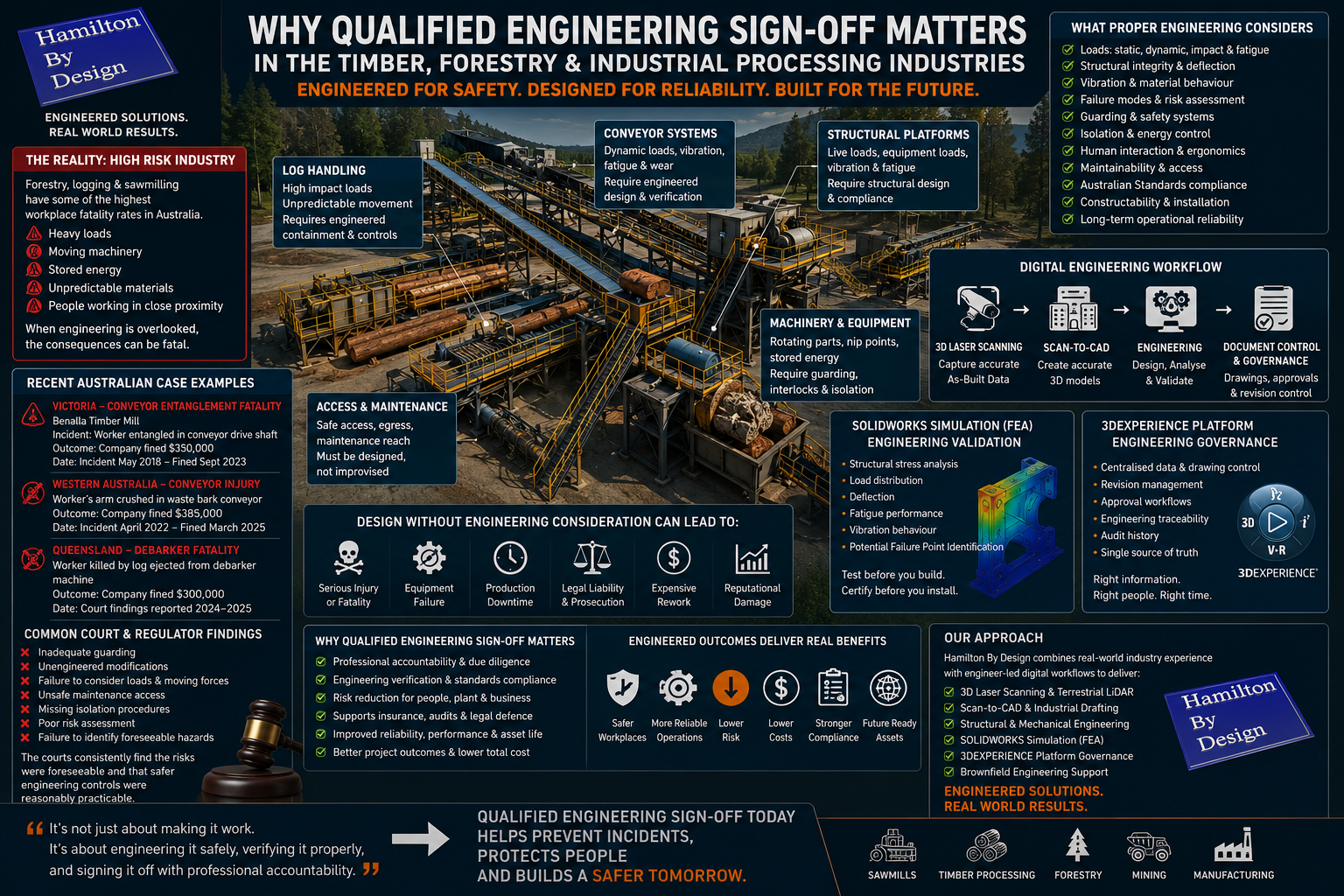
Across Australia’s forestry, sawmill and timber processing industries, industrial infrastructure continues to evolve through ongoing maintenance, shutdown upgrades, plant expansions and operational modifications. Conveyor systems are extended, timber transfer systems are upgraded, structural steel platforms are altered, machinery is relocated and new processing equipment is integrated into ageing brownfield facilities that may have operated continuously for decades.
While many of these changes are often completed to improve productivity or maintain operational continuity, one of the greatest hidden risks within industrial environments is modifying or designing plant equipment without proper engineering review, engineering governance and qualified engineering sign-off.
In many industrial workplaces, practical trade experience is highly respected — and rightly so. Skilled tradespeople are essential to fabrication, installation, shutdown works, plant maintenance and operational reliability. However, building something that functions mechanically is not the same as engineering a system that is safe, compliant, reliable and suitable for long-term industrial operation.
This distinction becomes critically important in industries such as forestry, logging and timber processing where machinery regularly handles heavy loads, rotating equipment, moving conveyors, unstable timber products, stored energy and high-throughput material handling systems.
Across sawmills and timber processing facilities throughout Australia, industrial systems are exposed to continuous operational stresses involving vibration, shock loading, impact forces, moisture, abrasive materials, dust contamination and changing environmental conditions. Conveyor systems, debarkers, screw augers, bucket elevators, log transfer systems and structural platforms must all operate safely while supporting continuous production under demanding industrial conditions.
Without proper engineering consideration, even seemingly simple modifications can introduce serious risk.
Over the past several decades, Australian workplace regulators and courts have repeatedly prosecuted companies following incidents involving timber handling systems, conveyors, rotating shafts, sawmill machinery and plant modifications that failed to adequately consider engineering safety requirements.
In one Victorian timber mill incident, a worker died after becoming entangled in a conveyor drive shaft. WorkSafe Victoria later found that engineering controls and guarding solutions were reasonably practicable and could have prevented the fatality. In Western Australia, a timber processing company was fined after a worker suffered catastrophic arm injuries involving inadequately guarded conveyor equipment. In Queensland, a timber company faced prosecution after a worker was killed by a log ejected from a debarker machine.
Although each incident involved different operational circumstances, the underlying engineering failures followed remarkably similar patterns:
inadequate guarding,
unengineered plant modifications,
failure to consider loads and moving forces,
unsafe maintenance access,
missing isolation procedures,
poor risk assessment,
insufficient structural verification,
lack of engineering review,
and failure to identify foreseeable operational hazards.
These are engineering failures — not simply fabrication problems.
A tradesperson may know how to weld, fabricate, cut or assemble industrial equipment, but engineering requires a much deeper understanding of how systems behave under operational conditions over time.
Proper engineering design must consider:
static and dynamic loading,
fatigue and cyclic stresses,
vibration,
structural deflection,
torque and rotational forces,
impact loading,
material behaviour,
wear characteristics,
human interaction with machinery,
guarding requirements,
maintainability,
failure modes,
constructability,
Australian Standards compliance,
and long-term operational reliability.
This is why qualified engineering sign-off matters.
Engineering sign-off is not simply a signature placed on a drawing. It represents professional accountability that the design has been reviewed, assessed and verified against engineering principles, foreseeable operational conditions and applicable standards.
Without proper engineering oversight, industrial businesses expose themselves to major commercial, operational and legal risk.
Poorly engineered modifications can lead to:
worker injury or fatalities,
structural failure,
conveyor collapse,
equipment damage,
production downtime,
voided insurance claims,
failed audits,
regulatory prosecution,
expensive shutdown rework,
project delays,
and reputational damage.
In many industrial facilities, the risk develops gradually over time. Equipment modifications are often completed during shutdowns or urgent maintenance periods where production pressure overrides long-term engineering review. Small undocumented changes accumulate over years until facilities no longer reflect their original engineered design intent.
Drawings become outdated. Loads change. Access paths are altered. Equipment is relocated. Platforms are modified. Conveyors are extended. Additional services are added.
Over time, facilities can drift significantly away from their original engineered condition.
This is where engineering governance becomes critically important.
At Hamilton By Design, we are an engineer-led organisation focused on delivering engineered outcomes rather than simply trade-based solutions.
While practical trade experience remains essential within industrial environments, our approach extends beyond fabrication and installation alone. We apply engineering thinking, digital engineering workflows and industrial experience to support long-term operational reliability, constructability and risk reduction.
Using engineering-grade 3D laser scanning, terrestrial LiDAR capture and scan-to-CAD workflows, we help industrial clients establish accurate as-built conditions before design or fabrication work begins.
Rather than relying on outdated PDFs or manual measurements, project teams gain access to highly accurate point cloud data that reflects real-world plant conditions. This allows engineers, fabricators and project managers to identify operational risks earlier and improve confidence before fabrication or construction begins.
Engineering-grade point clouds can then be converted into detailed CAD models suitable for:
structural analysis,
equipment integration,
plant upgrades,
fabrication detailing,
conveyor layouts,
clash detection,
and engineering verification.
One of the major advantages of modern digital engineering workflows is the ability to perform engineering validation before equipment is manufactured or installed onsite.
Using SOLIDWORKS Simulation and Finite Element Analysis (FEA), industrial components and structures can be digitally tested under operational loading conditions to assess how equipment may behave before fabrication occurs.
FEA allows engineers to evaluate:
structural stress,
deflection,
load distribution,
fatigue performance,
vibration behaviour,
and potential failure points.
This becomes particularly valuable within forestry and timber processing facilities where conveyor systems, transfer structures, platforms and machinery supports are exposed to continuous operational loading and vibration.
Rather than relying on assumptions or “rule of thumb” workshop modifications, FEA allows engineering decisions to be supported by measurable analysis and engineering verification.
This significantly improves confidence in the design process while helping reduce the risk of structural failure, overloading or premature wear.
At Hamilton By Design, digital engineering workflows can also be supported through the 3DEXPERIENCE platform, providing engineering governance and controlled management of industrial drawing systems and project information.
Modern industrial projects increasingly require:
revision control,
controlled approvals,
drawing issue states,
engineering traceability,
audit history,
and a single source of truth across multiple project stakeholders.
The 3DEXPERIENCE platform supports this by allowing controlled management of CAD models, drawings, revisions and engineering workflows within a centralised digital environment.
This provides significant advantages for industrial and brownfield projects where multiple contractors, engineers, fabricators and maintenance teams may all be interacting with the same plant infrastructure over long operational lifecycles.
Engineering governance through structured drawing control helps ensure:
approved drawings remain current,
revision history is traceable,
superseded drawings are controlled,
engineering changes are documented,
and project teams are working from reliable information.
In industries such as forestry, timber processing, mining and manufacturing, poor drawing control can create major operational and safety risks if outdated or unverified information is used during fabrication or construction activities.
At Hamilton By Design, our workflows focus on engineering-grade deliverables designed to support practical industrial outcomes.
This includes:
engineering-grade 3D laser scanning,
terrestrial LiDAR capture,
scan-to-CAD workflows,
industrial drafting,
structural and mechanical modelling,
FEA-supported engineering workflows,
revision-controlled drawing systems,
and brownfield engineering support.
We do not simply create geometry or visualisation models.
We focus on engineering workflows designed to support real-world industrial reliability, constructability and operational performance.
Because in high-risk industrial environments, “it works” is not the same as “it has been engineered safely.”
Qualified engineering sign-off matters because the consequences of poor engineering decisions can extend far beyond production downtime — affecting worker safety, operational reliability, legal liability and the long-term success of industrial infrastructure.
If your business is seeking engineered outcomes that outlast short-term fixes, Hamilton By Design provides engineer-led digital engineering support designed to help reduce risk and engineer success across industrial operations throughout Australia.
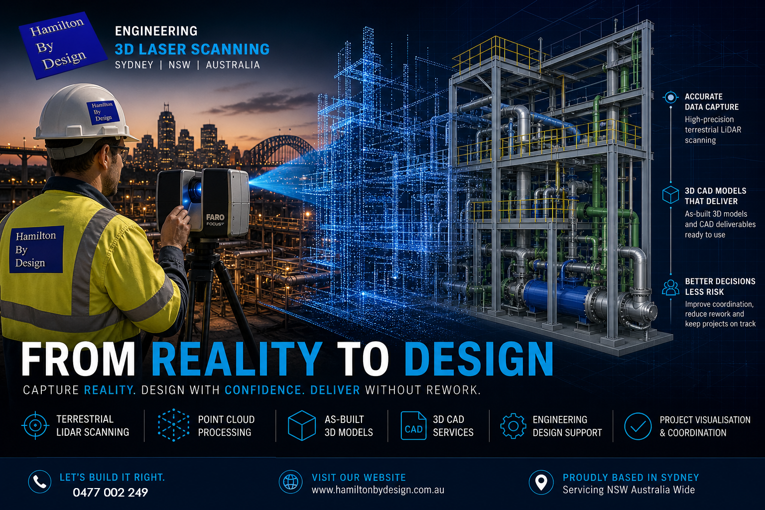
In today’s construction and industrial environment, the gap between what was designed and what actually exists on site is where most project risk lives.
Steel doesn’t sit where drawings say it should. Pipework clashes with new installs. Structural tolerances stack up. And when projects move fast, those risks become expensive.
This is where engineering-led 3D scanning and design changes everything.
At Hamilton By Design, we don’t just capture data — we convert reality into accurate, buildable engineering outcomes.
The Shift from Measuring to Reality Capture
Traditional site measurement methods rely on tape measures, total stations, and assumptions. They work — but they introduce risk.
Modern projects are moving toward terrestrial LiDAR scanning, using high-accuracy laser-based systems to capture millions of data points across a site.
A terrestrial LiDAR scanner works by emitting laser pulses and measuring the return time to build a precise 3D representation of the environment — known as a point cloud.
This process, often referred to as a terrestrial scan, creates a true digital record of:
Structural steel
Pipework systems
Equipment layouts
Buildings and facades
Complex plant geometry
The result is not an interpretation — it is reality.
From Point Cloud to As-Built 3D Model
Capturing data is only the first step.
The real value comes from converting that scan into an as-built 3D model that engineers, designers, and fabricators can actually use.
This is where many providers fall short.
At Hamilton By Design, we deliver:
Engineering-grade 3D CAD services
Parametric models (not mesh files)
Fabrication-ready geometry
Drawings aligned to Australian standards
We don’t produce STL or OBJ files that sit unused. We produce editable 3D engineering design models that integrate directly into your workflow.
Because ultimately — scanning is not the deliverable.
Design is.
3D Scanning on Construction Sites
The use of 3D scanning on construction sites is growing rapidly — and for good reason.
Projects across Sydney are using LiDAR to:
Verify structural installation before fit-up
Coordinate mechanical and piping systems
Reduce rework during shutdowns
Validate contractor work against design intent
Capture existing conditions for upgrades
Whether it’s a building scan, plant upgrade, or infrastructure project, the ability to see the full site in 3D changes how teams make decisions.
Instead of relying on drawings — teams work from reality.
Top 3D Scanning Platforms for Project Coordination
Not all scanning workflows are equal.
The top 3D scanning platforms for construction site visualisation and project coordination combine accurate capture with accessible data environments.
Typical platforms include:
FARO SCENE for registration and processing
Autodesk ReCap for cloud-based coordination
3DEXPERIENCE for engineering governance and collaboration
However, the platform is only part of the equation.
Without engineering understanding, even the best software becomes a viewer — not a solution.
That’s why our workflow is built around:
Scan → Model → Design → Deliver
Engineering-Led 3D Design
What sets Hamilton By Design apart is simple:
We are a mechanical engineering business first — not a scanning company.
Our team uses LiDAR to support:
3D design engineering
Structural modifications
Conveyor and chute design
Pipework upgrades
Equipment integration
We scan with the intent of answering one question:
👉 Will it fit?
Because in engineering — that’s what matters.
Why “3D Scanner Service Near Me” Isn’t Enough
Many clients search for a “3D scanner service near me” or look at 3D scanner hire as a cost-saving measure.
But scanning hardware alone does not solve engineering problems.
Without:
Proper scan planning (line of sight, density, coverage)
Registration accuracy
Engineering interpretation
CAD modelling capability
…the result is just raw data.
We often see projects where scanning was completed — but nothing usable was produced.
That’s why we offer both:
Full 3D scan services
3D scanner hire (with guidance)
End-to-end modelling and design support
Applications Across Buildings and Industry
Our 3D scanning building services and industrial workflows support a wide range of sectors across Sydney and NSW:
Construction & Buildings
As-built verification
Facade capture
Structural coordination
Scan-to-BIM workflows
Industrial Plants
Brownfield upgrades
Shutdown planning
Equipment replacement
Pipe routing and clash detection
Infrastructure
Rail and transport assets
Utilities and pump stations
Structural assessments
Whether it’s a commercial building or a complex processing plant, the principle is the same:
Capture reality. Design with confidence. Deliver without rework.
The Future: Digital Engineering Driven by LiDAR
LiDAR is not just a tool — it is the foundation of modern digital engineering design.
As projects become more complex, the ability to:
Capture accurate site data
Build reliable 3D models
Coordinate across teams
Maintain a single source of truth
…will define successful delivery.
At Hamilton By Design, we combine:
Terrestrial LiDAR scanning
3D CAD services
Engineering design expertise
to ensure that what gets built — matches what was intended.
Work With an Engineer-Led 3D Scanning Team
If you’re planning a project in Sydney or across NSW and need:
A 3D scan service
An as-built 3D model
3D engineering design support
we’re ready to help.
Because the difference between scanning and engineering is simple:
👉 One captures data. 👉 The other delivers outcomes.
Hamilton By Design provides engineering-led 3D scanning, LiDAR scanning, mechanical engineering and digital engineering services throughout Sydney and Greater Sydney.
Explore our related Sydney services:
3D Scanning Sydney – Engineering-grade terrestrial laser scanning, as-built surveys and point cloud capture for industrial, infrastructure and commercial projects.
Reality Capture Sydney – High-accuracy reality capture, digital twins, asset documentation and engineering-grade site verification.
Scan to CAD Sydney – Convert point cloud data into AutoCAD, SolidWorks, Inventor and other engineering-ready CAD deliverables.
Point Cloud Modelling Sydney– Engineering-grade point cloud processing, clash detection, as-built verification and 3D modelling.
Mechanical Engineering Sydney – Mechanical design, plant upgrades, materials handling systems, conveyors, chutes, platforms and engineering support.
Structural Drafting Sydney– Structural steel drafting, fabrication drawings, GA drawings, workshop detailing and as-built documentation.
Hamilton By Design supports projects throughout Sydney CBD, Parramatta, Liverpool, Penrith, Blacktown, Chatswood, Alexandria, Mascot, Newcastle and the Central Coast.
Hamilton By Design provides engineer-led 3D scanning, reality capture, structural drafting and scan-to-design services across Sydney, Parramatta, Penrith, Liverpool and the Blue Mountains.
We support industrial, commercial and infrastructure projects where accurate site information is required before design, fabrication, modification or installation work begins.
Unlike basic LiDAR providers or visual scanning services, our workflow is focused on engineering outcomes. We do not simply capture a point cloud and hand it over. We scan with the end design, drafting and construction process in mind.
From Site Scan to Engineering Design
A successful project starts with accurate site data. Our mobile 3D scanning services allow existing structures, plant rooms, pipework, equipment, access platforms, buildings and industrial assets to be captured in detail.
The scan data can then be used to develop:
As-built drawings
Structural drafting
Mechanical layouts
Point cloud to CAD models
Design verification models
Fabrication-ready geometry
Site coordination drawings
Modification and upgrade layouts
This process reduces the risk of relying on outdated drawings, manual measurements or assumptions made from site photos.
Reality Capture Sydney
Reality capture provides a digital record of the existing site condition. For brownfield sites, commercial buildings, industrial plants and infrastructure assets, this is often the most reliable starting point for design.
Hamilton By Design provides reality capture services across Sydney, including Parramatta, Penrith, Liverpool and the Blue Mountains. Our scanning process is suited to projects where geometry, clearances, access, structural interfaces and installation constraints matter.
3D Scanning Services Parramatta
For projects in Parramatta and Western Sydney, 3D scanning can assist with building upgrades, plant modifications, structural steel layouts, services coordination and as-built documentation.
Our team can capture the existing site and develop usable CAD information for engineers, builders, fabricators and project managers.
3D Laser Scanning Penrith and Blue Mountains
Hamilton By Design also provides 3D laser scanning services in Penrith and the Blue Mountains.
These areas often include a mix of industrial, commercial, civil and difficult-access sites. A 3D scanner can capture complex geometry quickly and accurately, helping project teams understand the real site condition before design or construction begins.
3D Scanning Liverpool
For Liverpool and South-West Sydney, our 3D scanning services support commercial buildings, industrial facilities, warehouses, workshops and infrastructure-related projects.
Scanning is particularly useful when existing drawings are missing, unreliable or not detailed enough for modification work.
Structural Drafting Sydney
Hamilton By Design provides structural drafting services in Sydney using accurate site data from 3D scanning where required.
This is valuable for:
Structural steel modifications
Access platforms
Mezzanine structures
Plant support steelwork
Equipment bases
Walkways and maintenance access
Existing building documentation
Fabrication coordination
By combining structural drafting with scan data, we help reduce clashes, rework and uncertainty during fabrication and installation.
As-Built Drawing Services vs LiDAR Providers
There is an important difference between basic LiDAR scanning and engineering-grade as-built documentation.
A LiDAR provider may capture a point cloud. However, an engineering-led workflow considers what the point cloud needs to become.
Hamilton By Design focuses on the full digital engineering workflow:
This means the scan is captured with an understanding of engineering intent, line of sight, constructability, component fit-up and drafting requirements.
Point Cloud Scanning Services
Our point cloud scanning services can provide a reliable digital record of existing conditions. Depending on the project scope, deliverables may include:
Registered point cloud data
Point cloud viewing files
CAD-ready reference data
As-built drawings
3D models
Structural or mechanical design layouts
Sections, elevations and general arrangement drawings
Point cloud data is especially useful where projects involve existing structures, old drawings, tight clearances or complex site interfaces.
Mobile 3D Scanning Services
Hamilton By Design provides mobile 3D scanning services across Sydney and surrounding regions. We can attend site, scan the required area and develop practical engineering deliverables from the captured data.
This service is suited to:
Industrial sites
Commercial buildings
Warehouses
Plant rooms
Workshops
Mining and bulk handling equipment
Building upgrades
Structural steel projects
Mechanical equipment installations
Why Choose Hamilton By Design
Hamilton By Design is an engineer-led organisation. We provide more than visual scanning. Our focus is on accurate site capture, practical modelling and design-ready documentation.
We understand that project teams need information they can use for design, fabrication, installation and decision-making.
Our scan-to-design workflow helps clients move from uncertain site conditions to clear engineering deliverables.
Our Clients
Service Areas
Hamilton By Design provides 3D scanning, structural drafting and reality capture services across:
Sydney, Parramatta, Penrith, Liverpool, Blue Mountains, Western Sydney, Central Coast, Newcastle and surrounding regions.
Talk to Hamilton By Design
If your project requires 3D scanning, point cloud scanning services, as-built drawing services, structural drafting or scan-to-design support, Hamilton By Design can assist from site capture through to engineering documentation.
We help turn real-world site conditions into practical digital engineering information.
Hamilton By Design provides engineering-led 3D scanning, LiDAR scanning, mechanical engineering and digital engineering services throughout Sydney and Greater Sydney.
Explore our related Sydney services:
3D Scanning Sydney – Engineering-grade terrestrial laser scanning, as-built surveys and point cloud capture for industrial, infrastructure and commercial projects.
Reality Capture Sydney – High-accuracy reality capture, digital twins, asset documentation and engineering-grade site verification.
Scan to CAD Sydney – Convert point cloud data into AutoCAD, SolidWorks, Inventor and other engineering-ready CAD deliverables.
Point Cloud Modelling Sydney– Engineering-grade point cloud processing, clash detection, as-built verification and 3D modelling.
Mechanical Engineering Sydney – Mechanical design, plant upgrades, materials handling systems, conveyors, chutes, platforms and engineering support.
Structural Drafting Sydney– Structural steel drafting, fabrication drawings, GA drawings, workshop detailing and as-built documentation.
Hamilton By Design supports projects throughout Sydney CBD, Parramatta, Liverpool, Penrith, Blacktown, Chatswood, Alexandria, Mascot, Newcastle and the Central Coast.
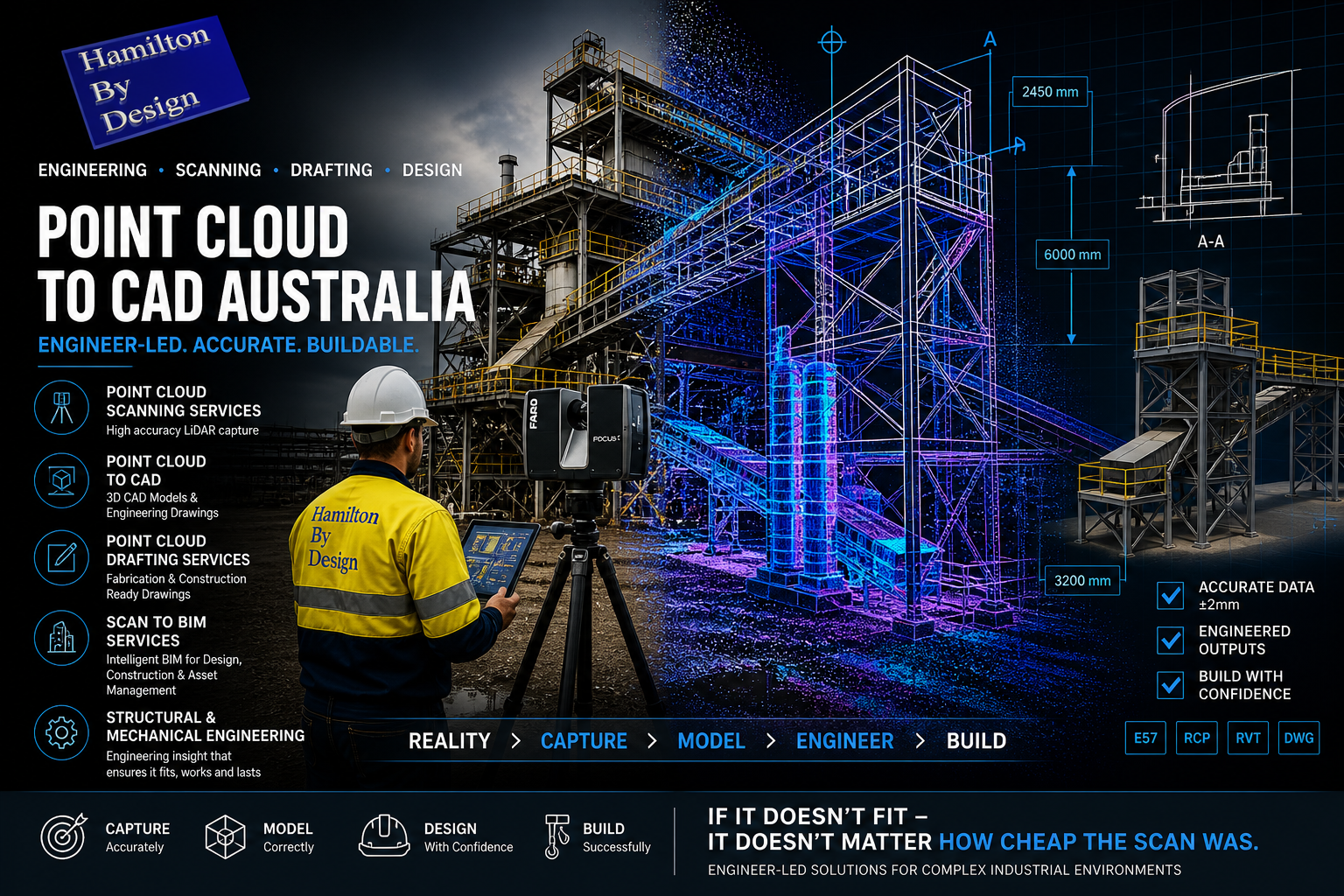
Engineer-Led Point Cloud to CAD Services Across Australia
At Hamilton By Design, we deliver engineering-grade point cloud to CAD services in Australia, purpose-built for industrial, mining, and complex mechanical environments.
We are not a visualisation or real estate scanning company.
We are a structural mechanical engineering-led organisation, using high-accuracy LiDAR scanning to support real-world design, fabrication, and construction outcomes.
What We Do
We provide a complete workflow from point cloud scanning through to engineered deliverables, including:
Point cloud scanning services (LiDAR reality capture)
Point cloud to CAD conversion (2D & 3D)
Point cloud drafting services for fabrication and construction
Scan to BIM services for buildings and infrastructure
Mechanical and structural engineering integration
Our focus is simple:
👉 Capture accurately. Model correctly. Design with confidence.
Point Cloud Scanning Service (Engineering Grade)
Our scanning services are built around engineering accuracy, not visual output.
Using high-precision LiDAR systems, we capture:
Industrial plants and processing facilities
Conveyor systems, chutes, and transfer stations
Structural steel and platforms
Pipework and mechanical systems
Existing buildings and infrastructure
Unlike low-cost scanning providers, we scan with design intent in mind — ensuring the data can be used for:
Fabrication fit-up
Brownfield upgrades
Shutdown planning
Engineering verification
Point Cloud to CAD Australia
We convert raw point cloud data into usable engineering models and drawings, including:
3D CAD models (SolidWorks-based workflows)
2D AutoCAD drawings (plans, sections, elevations)
General Arrangement (GA) drawings
Fabrication-ready outputs
Our models are developed to support:
Clash detection
Design validation
Accurate measurement and geometry extraction
Integration into existing engineering workflows
Point Cloud Drafting Services
Our drafting services go beyond simple tracing.
We deliver engineering-controlled documentation, including:
Revision-controlled drawings (IFR / IFA / IFC)
Structured layouts driven from 3D models
Consistent drawing standards aligned with Australian practice
Clear geometry for fabrication and installation
This ensures your drawings are not just “drawn” — they are buildable.
Scan to BIM Services
For building and infrastructure projects, we offer Scan to BIM services tailored for:
Commercial buildings
Government assets
Industrial facilities
Upgrade and refurbishment projects
We create intelligent BIM models that support:
Asset management
Design coordination
Construction planning
Lifecycle management
Structural Mechanical Engineer-Led Approach
This is where Hamilton By Design is different.
We are not technicians capturing data.
We are engineers solving problems.
Our team understands:
Load paths and structural behaviour
Mechanical fit-up and tolerances
Fabrication constraints
Installation sequencing
Australian Standards and compliance requirements
This means:
👉 We scan with purpose 👉 We model with intent 👉 We design for reality
Why Engineer-Led Scanning Matters
Low-cost scanning often leads to:
Incomplete data
Poor alignment
Unusable geometry
Costly rework during fabrication
Our approach eliminates that risk.
We provide:
Engineering-grade accuracy
Clear, structured deliverables
Confidence in fit and function
Because at the end of the day:
👉 If it doesn’t fit — it doesn’t matter how cheap the scan was.
Typical Applications
Our services are used across:
Mining & Heavy Industry
Conveyor upgrades
Transfer chute design
Plant modifications
Shutdown engineering
Industrial Plants
Brownfield expansions
Pipe routing and modifications
Structural upgrades
Buildings & Infrastructure
Scan to BIM for refurbishments
As-built documentation
Structural verification
Deliverables
Depending on your scope, we can provide:
Registered point clouds (.E57 / .RCP / .LAS)
Scan location plans
3D CAD models
2D engineering drawings
BIM models
Engineering review and input
Work With Hamilton By Design
If you are looking for:
Point cloud to CAD Australia
Reliable point cloud scanning service
Professional point cloud drafting services
High-quality scan to BIM services
A structural mechanical engineer who understands real-world constraints
Then we’re ready to support your project.
Get Started
We typically operate on a day rate basis, with clear scope and deliverables.
📩 Contact us today to:
Discuss your project
Arrange a site visit
Receive a proposal
Final Word
At Hamilton By Design, we don’t just capture data.
To provide the best experiences, we use technologies like cookies to store and/or access device information. Consenting to these technologies will allow us to process data such as browsing behaviour or unique IDs on this site. Not consenting or withdrawing consent, may adversely affect certain features and functions.
Functional
Always active
The technical storage or access is strictly necessary for the legitimate purpose of enabling the use of a specific service explicitly requested by the subscriber or user, or for the sole purpose of carrying out the transmission of a communication over an electronic communications network.
Preferences
The technical storage or access is necessary for the legitimate purpose of storing preferences that are not requested by the subscriber or user.
Statistics
The technical storage or access that is used exclusively for statistical purposes.The technical storage or access that is used exclusively for anonymous statistical purposes. Without a subpoena, voluntary compliance on the part of your Internet Service Provider, or additional records from a third party, information stored or retrieved for this purpose alone cannot usually be used to identify you.
Marketing
The technical storage or access is required to create user profiles to send advertising, or to track the user on a website or across several websites for similar marketing purposes.