3D Scanning Services Darwin: Industrial LiDAR for As-Builts, Shutdowns & Brownfield Upgrades


3D Scanning Services Darwin | Industrial LiDAR for Engineering Projects

In Darwinโ€™s industrial and infrastructure sectors, accurate site data is critical before any upgrade, shutdown or retrofit project begins. Many facilities are operating with outdated drawings, undocumented modifications and congested plant layouts โ€” making traditional site measurement slow, risky and unreliable.

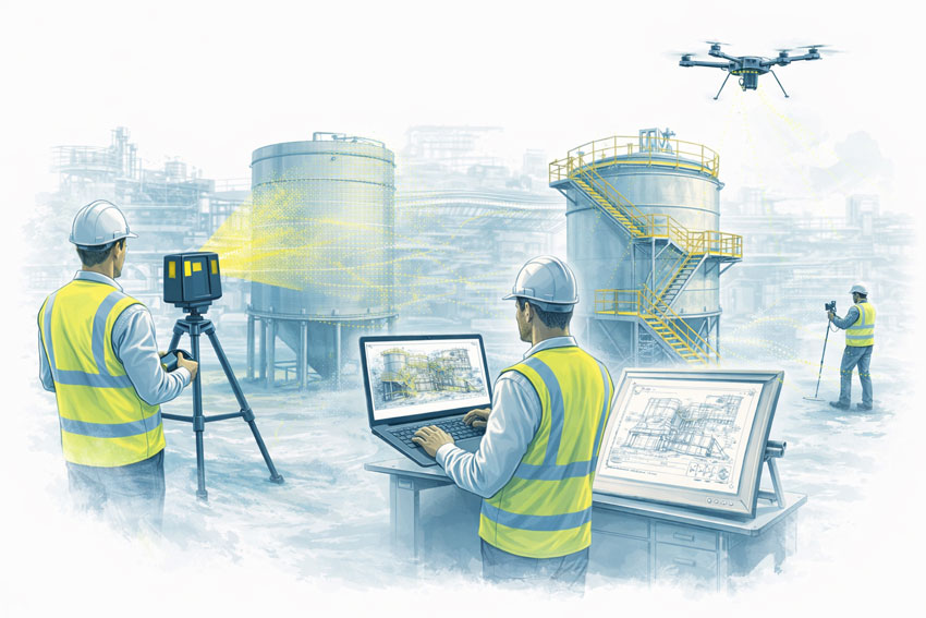
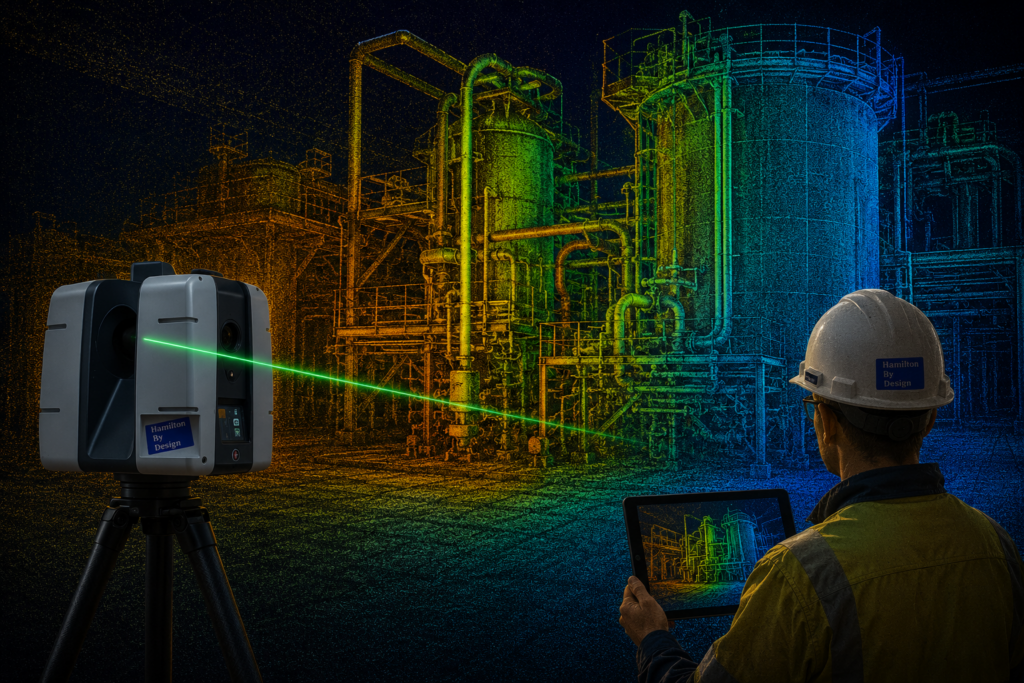
Engineering-grade 3D LiDAR scanning provides fast, highly accurate as-built data that engineers can rely on for design, fabrication and installation planning. At Hamilton By Design, we deliver industrial 3D scanning services in Darwin that support brownfield upgrades, shutdown works and asset documentation across mining, ports, defence and utilities.


What Is Engineering-Grade 3D Scanning?

Unlike basic surveying or photogrammetry, industrial LiDAR scanning captures millions of measurement points per second to generate a true-scale point cloud of your facility.

This allows engineers to:

  • Measure clearances accurately
  • Verify structural geometry
  • Detect clashes before fabrication
  • Design directly from real-world data

Our workflows convert point cloud data into:

  • CAD models
  • Fabrication drawings
  • BIM and coordination models
  • As-built documentation

This means scanning is not just a survey โ€” it becomes the foundation of your entire engineering workflow.


Industrial LiDAR scanning of a processing plant with colourful point cloud visualisation and engineer reviewing 3D scan data on site

Key Industries Using 3D Scanning in Darwin

Darwin is a major hub for industrial and infrastructure projects across Northern Australia. The most common users of LiDAR scanning include:

Defence & Secure Facilities

  • Hangars, workshops and logistics buildings
  • Fuel systems and plant rooms
  • Retrofit and compliance upgrades

Scanning allows engineers to design remotely while reducing on-site access requirements and security risks.


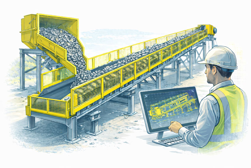
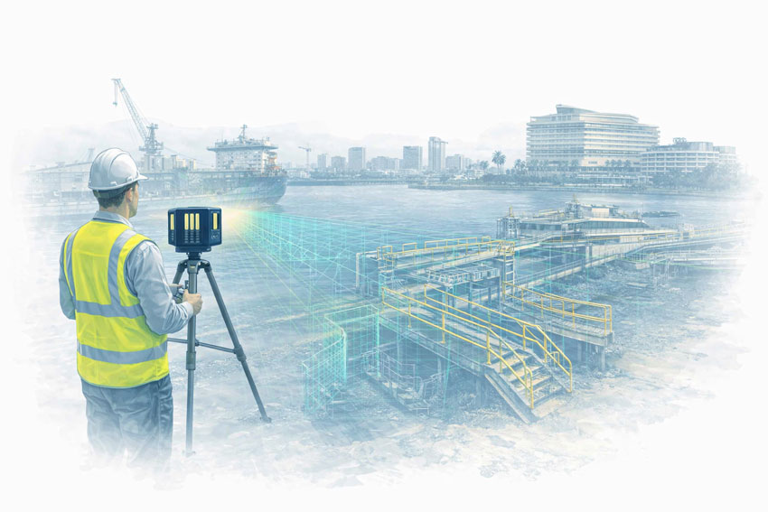
Ports, Marine & Bulk Handling Infrastructure

  • Conveyors and transfer stations
  • Wharf structures and ship loaders
  • Upgrade planning without interrupting operations

LiDAR scanning enables safe measurement of live operating assets and complex marine structures.


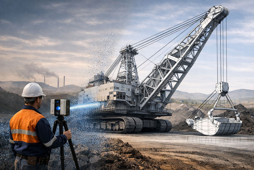
Mining Support & Materials Handling

While many mines are remote, engineering and fabrication is often coordinated through Darwin.

Typical applications include:

  • Transfer chute redesign
  • Conveyor upgrades
  • Structural tie-ins during shutdowns

Accurate scans reduce installation risk and minimise costly shutdown overruns.


Oil, Gas & LNG Support Facilities

  • Skid and modular plant design
  • Pipe routing and equipment replacement
  • Brownfield retrofit engineering

Scanning ensures new modules fit first time, even when original drawings are incomplete.


Government Infrastructure & Utilities

  • Water and wastewater treatment plants
  • Power generation and substations
  • Asset documentation and compliance works

As-built scanning supports long-term asset management and future upgrade planning.


Common Problems 3D Scanning Solves

Engineering teams typically engage scanning when they face:

  • Missing or inaccurate drawings
  • Congested plant layouts
  • High risk of installation clashes
  • Tight shutdown windows
  • Remote engineering coordination

By capturing the full environment, engineers can design with confidence and reduce rework during construction.


Typical Deliverables From a Darwin LiDAR Scan

Depending on your project, we can provide:

  • Registered point clouds (E57 / RCP formats)
  • 3D CAD models for design
  • Fabrication and installation drawings
  • Structural verification models
  • BIM coordination models
  • As-built documentation packages

This allows scanning data to be used directly by mechanical, structural and drafting teams.


Why Industrial Projects Choose Hamilton By Design

Hamilton By Design is an engineering-led scanning and modelling provider, not just a survey company.

Our clients value that we understand:

  • Shutdown scheduling pressures
  • Fabrication tolerances
  • Installation constraints
  • Australian Standards compliance
  • Mining and industrial safety requirements

This means the data we deliver is practical for real-world construction and maintenance projects, not just visually accurate.


When Should You Use 3D Scanning on Your Project?

3D scanning is most valuable when:

  • Modifying existing plant or structures
  • Designing replacement equipment
  • Planning shutdown installations
  • Verifying compliance or structural alignment
  • Preparing for major upgrades

Early scanning often prevents downstream engineering changes and costly site delays.


3D Scanning Services Available Across Darwin and the Top End

We support projects in:

  • Darwin industrial precincts
  • Port and marine facilities
  • Remote mining and processing sites
  • Defence infrastructure environments

Our team can mobilise scanning crews and deliver digital models suitable for immediate engineering use.


Hamilton By Design logo displayed on a blue tilted rectangle with a grey gradient background

3D LiDAR scanning and 3D modelling service button โ€” laser scanner capturing a point cloud for engineering and CAD modelling
Mechanical engineering services

Speak With an Engineer About Your Darwin Scanning Project

If you are planning upgrades, shutdown work or plant modifications, accurate site data is the first step toward reducing risk and improving delivery outcomes.

Contact Hamilton By Design to discuss industrial 3D scanning services in Darwin and how LiDAR data can support your engineering and fabrication workflow.

Name
Would you like us to arrange a phone consultation for you?
Address

3D CAD Modelling Australia service banner for Hamilton By Design


CHPP Engineering title graphic featuring bold white text reading "CHPP Engineering" centred on a blue rounded rectangle background.
Pipework Drafting title graphic featuring bold white text reading "Pipework Drafting" centred on a blue rounded rectangle background.
3D LiDAR Scanning for Engineering Projects title graphic featuring bold white text on a blue rounded rectangle background.


Finite Element Analysis (FEA) engineering simulation button
Structural drafting services button
Mechanical drafting services button


Australian Drafting logo featuring bold white text reading "Australian Drafting" centred on a blue rounded rectangle background.
Engineering Governance title graphic featuring bold white text reading "Engineering Governance" centred on a blue rounded rectangle background.
Engineering-Grade LiDAR Scanning title graphic featuring bold white text on a blue rounded rectangle background.


Mechanical drafting services button
Structural drafting services button


Fabrication and product design services
3D CAD Modelling Australia service banner for Hamilton By Design
Mechanical, Structural & Pipework Drafting service banner by Hamilton By Design featuring white text on a blue background.


3D LiDAR scanning and 3D modelling service button โ€” laser scanner capturing a point cloud for engineering and CAD modelling
Mechanical engineering services

3D Laser Scanning in Rockhampton QLD: Engineering-Grade Data for Safer Conveyor Design and Risk Management

Engineering-led SolidWorks drafting in Australia with 25 years of Hamilton By Design experience

3D Laser Scanning in Rockhampton QLD for Safer Conveyor Design & Risk Management

Rockhampton plays a critical role in Central Queenslandโ€™s heavy industry, supporting mining, bulk materials handling, agriculture, and transport infrastructure. Across these sectors, conveyor systems are essential โ€” and they are also one of the highest-risk assets on site.

As facilities age and production demands increase, many operators are upgrading or modifying conveyors within tight shutdown windows. In these environments, engineering-grade 3D laser scanning (LiDAR) is becoming a key tool for reducing design risk, improving safety outcomes, and avoiding costly site rework.

At Hamilton By Design, we use high-accuracy 3D scanning to capture existing plant conditions and convert them into reliable engineering models that support safer conveyor design and more effective risk management.

Conveyor Systems and Industry Incidents: Where Things Go Wrong

Industry incident investigations across Queensland repeatedly identify similar contributing factors in conveyor-related injuries:

  • Inadequate guarding at transfer points and pulleys
  • Restricted access forcing unsafe maintenance practices
  • Plant modifications made without updated drawings
  • Design reviews based on outdated or incomplete site data

In regional facilities around Rockhampton, conveyors are often extended, repaired, and repurposed over many years. What starts as a temporary modification can become permanent, and original drawings no longer reflect reality on the ground.

When new upgrades are designed using assumptions instead of accurate geometry, risk is built into the project from day one.


Bulk materials conveyor with compliant safety guarding at the hopper, tail end, and along the conveyor, shown with an engineer reviewing guarding design drawings.

Why Engineering-Grade Scanning Matters for Conveyor Design

Not all 3D scans are suitable for mechanical design or safety-critical decisions.

We use engineering-grade LiDAR scanning capable of delivering accuracy in the order of ยฑ2 mm over 70 metres, allowing engineers to:

  • Model conveyor structures, frames, and supports
  • Accurately locate rollers, drives, guards, and transfer chutes
  • Verify clearances for new equipment and walkways
  • Identify clashes before fabrication and installation

The resulting point clouds and CAD models form a reliable digital baseline that engineers, safety teams, and maintenance planners can all work from.

When plant modifications are driven by accurate data, both design quality and safety outcomes improve.

Safe Design Starts with Knowing What Actually Exists

Safe Design is not something that can be retrofitted easily once steel is fabricated and installed.

Scan-based models allow hazards to be assessed during the design phase, including:

  • Access and egress routes for maintenance
  • Reach distances and pinch point exposure
  • Guarding coverage around rotating equipment
  • Space constraints that may encourage unsafe shortcuts

This is particularly important in conveyor corridors where multiple services, structures, and walkways compete for limited space.

Designing from accurate site geometry allows risks to be eliminated or reduced before they reach the worksite.


Risk Management Through Reality Capture

From a risk management perspective, 3D scanning supports more than just design accuracy. It also improves:

  • Hazard identification and risk assessments
  • Method statements and installation planning
  • Shutdown coordination and contractor interfaces
  • Compliance documentation and audit trails

Point cloud data also provides a permanent record of asset condition at a point in time, which can be invaluable for:

  • Future upgrade planning
  • Incident investigations
  • Asset integrity assessments

In high-risk conveyor environments, reliable data is a control measure in its own right.

Supporting Rockhampton Industry with Integrated Engineering Services

Hamilton By Design provides on-site 3D scanning and mechanical engineering support for projects in Rockhampton and Central Queensland, including:

  • Conveyor upgrades and replacements
  • Transfer point redesigns
  • Guarding and access improvements
  • Brownfield plant modifications
  • Fabrication and installation planning

Because we are an engineering-led team, scanning is directly integrated into mechanical design, drafting, and fabrication support โ€” not treated as a standalone survey service.

This ensures models are built to suit engineering workflows and deliver practical, buildable outcomes.


Hamilton By Design logo displayed on a blue tilted rectangle with a grey gradient background

3D LiDAR scanning and 3D modelling service button โ€” laser scanner capturing a point cloud for engineering and CAD modelling
Mechanical engineering services

From Point Cloud to Practical Results

Our typical workflow includes:

  1. On-site LiDAR scanning with minimal operational disruption
  2. Registration and processing of point cloud data
  3. Conversion into CAD models suitable for mechanical design
  4. Design development, safety reviews, and shop drawings

This approach reduces shutdown risk, improves installation accuracy, and helps ensure safety improvements are achieved in practice โ€” not just on paper.

Name
Would you like us to arrange a phone consultation for you?
Address
3D LiDAR scanning and 3D modelling service button โ€” laser scanner capturing a point cloud for engineering and CAD modelling
Mechanical engineering services
Finite Element Analysis (FEA) engineering simulation button
Mechanical engineering services

What Is the Difference Between a Terrestrial Scanner and a LiDAR Scanner?

Terrestrial, mobile SLAM and drone LiDAR scanners capturing an industrial plant with engineers reviewing point cloud data and drawings

Terrestrial vs LiDAR Scanners | Whatโ€™s the Difference?

Confusion around terrestrial scanning and LiDAR scanning is common โ€” and understandable.
The two terms are often used interchangeably, even though they describe different things.

This page explains the difference in plain language, shows where each approach fits, and helps you decide what level of accuracy and risk is appropriate for your project.


Short Answer (If Youโ€™re in a Hurry)

LiDAR describes the laser measurement technology.
Terrestrial describes how and where that LiDAR scanner is deployed.

Most terrestrial scanners use LiDAR, but not all LiDAR scanners are terrestrial.


Illustration comparing terrestrial LiDAR, mobile SLAM LiDAR and drone scanning on an industrial facility

What Is LiDAR?

LiDAR (Light Detection and Ranging) is a method of measuring distance using laser light.

How LiDAR works

  • A laser pulse is emitted
  • The pulse reflects off an object
  • The return time is measured
  • Distance is calculated and stored as a 3D point

Millions of these points form a point cloud that represents real-world geometry.

What LiDAR is good for

  • Accurate 3D measurement
  • Complex geometry
  • Low-light or enclosed environments
  • Engineering, construction, and industrial sites

LiDAR answers: How is distance measured?


What Is a Terrestrial Scanner?

A terrestrial scanner is a ground-based scanning system, usually mounted on a tripod or fixed position.

Key characteristics

  • Fixed scan position
  • Controlled setup and coverage
  • Known geometry and reference
  • High repeatability and validation

Typical environments

  • Processing plants and CHPPs
  • Structural steelwork
  • Conveyor systems
  • Brownfield tie-ins
  • As-built verification
  • Shutdown-critical fit-up work

Terrestrial answers: Where and how is the LiDAR deployed?


How the Two Terms Relate (This Is the Important Part)

A terrestrial scanner is a platform.
A LiDAR scanner is a technology.

Most modern terrestrial scanners are terrestrial LiDAR scanners.

Example: a tripod-mounted system such as the FARO Focus S-Series is:

  • LiDAR-based (laser measurement)
  • Terrestrial (ground-based, fixed setup)

Other Common LiDAR Scanner Types (And Why It Matters)

Scanner TypeHow Itโ€™s UsedTypical Outcome
Terrestrial LiDARTripod / fixedHighest control & accuracy
Mobile / SLAM LiDARHandheld / walk-throughFast capture, lower control
Vehicle-mounted LiDARCar / trolleyCorridor mapping
Aerial LiDARDrone / aircraftLarge areas, low detail

All are โ€œLiDARโ€, but not all are suitable for engineering design or fabrication.


Why This Distinction Matters for Projects

Many issues occur when:

  • A LiDAR scan is assumed to be engineering-grade
  • A mobile or SLAM scan is used beyond its intent
  • Accuracy, validation, or limitations are not clearly understood

This doesnโ€™t mean one method is wrong โ€” it means each has a purpose.

The key is aligning the scanner type with:

  • Required accuracy
  • Risk tolerance
  • Fit-up criticality
  • Intended use of the data

Our clients:


Simple Decision Guide (Client in Control)

If you need:

  • Fabrication or replacement parts โ†’ Terrestrial LiDAR
  • Shutdown-critical fit-up โ†’ Terrestrial LiDAR
  • Structural verification โ†’ Terrestrial LiDAR
  • Rapid site context only โ†’ Mobile / SLAM LiDAR
  • Large terrain or stockpiles โ†’ Aerial LiDAR

There is no โ€œone best scannerโ€ โ€” only the right scanner for the outcome you want.


Comparison at a Glance

RequirementTerrestrial LiDARMobile / SLAM LiDAR
Accuracy controlHighModerate
RepeatabilityHighLower
Engineering defensibilityStrongLimited
Fit-up confidenceSuitableNot recommended
Capture speedSlowerFaster
Best use caseDesign & fabricationVisualisation & context

A Note on Engineering Use

Where scanning data feeds into engineering design, documentation, or fabrication, higher-control methods are typically required to align with engineering practice and Australian Standards expectations.

That doesnโ€™t remove choice โ€” it simply means the assumptions and limitations must match the intended use.


How We Approach This (Without Locking You In)

Weโ€™re happy to:

  • Work with terrestrial, mobile, or supplied scan data
  • Validate data before design where required
  • Align scanning effort with your risk, budget, and outcome
  • Clearly document assumptions and limitations

You stay in control of the approach โ€” our role is to make sure the data supports the outcome you expect.


Hamilton By Design logo displayed on a blue tilted rectangle with a grey gradient background
3D LiDAR scanning and 3D modelling service button โ€” laser scanner capturing a point cloud for engineering and CAD modelling
Mechanical engineering services

Next Step

If youโ€™re unsure which scanning method suits your project:

Fill out the contact form and tell us:

  • What you want to build, replace, or verify
  • How the data will be used
  • Any constraints (budget, time, shutdown windows)

Weโ€™ll help you select a fit-for-purpose scanning approach, not just a scanner.


Name
Would you like us to arrange a phone consultation for you?
Address
Finite Element Analysis (FEA) engineering simulation button
Mechanical engineering services

Hunter Valley Laser Scanning | CAD-Ready SolidWorks & Inventor

Engineering-grade LiDAR scanning of a dragline at a Hunter Valley mine producing CAD-ready data for SolidWorks and Autodesk Inventor

Hunter Valley Laser Scanning | CAD-Ready SolidWorks & Inventor

Engineering-Grade 3D & LiDAR Scanning Built for SolidWorks & Autodesk Inventor

The Hunter Valley is home to critical mining, power generation, manufacturing, and heavy-industry assets. In these environments, laser scanning is only valuable if the data can be used directly in engineering design software.

At Hamilton By Design, we deliver Hunter Valley laser scanning services that are purpose-built for engineering workflows โ€” ensuring scan data can be reliably used in SolidWorks and Autodesk Inventor without rework, approximation, or loss of accuracy.


Why โ€œScan-Onlyโ€ Data Is a Problem

Many laser scanning services focus on data capture only. While the point cloud may look impressive, it often fails at the most important step:

Can the scan be used directly in CAD and engineering design?

If the answer is no, the scan has limited value.

Common issues with low-grade or technician-only scanning include:

  • Point clouds that are not registered or scaled correctly
  • Insufficient accuracy for mechanical design tolerances
  • Poor alignment to real-world coordinate systems
  • Data that cannot be reliably modelled in SolidWorks or Inventor
  • Extra time and cost spent โ€œfixingโ€ scan data before design can begin

Why would you spend money on a scan that cannot be used for engineering?


Engineer performing engineering-grade laser scanning of a dragline excavator at a Hunter Valley mine for SolidWorks and Autodesk Inventor design

3D LiDAR Scanning Hunter & Newcastle banner with white text on a blue background promoting engineering-grade laser scanning services for industrial, mining and infrastructure projects across the Hunter Valley and Newcastle region.
Mechanical Engineering Hunter & Newcastle banner promoting mechanical engineering services for mining, industrial plants, power generation, manufacturing and heavy industry throughout the Hunter Valley and Newcastle region.
Structural Drafting Hunter & Newcastle banner promoting structural drafting services for mining, industrial plants, power generation, manufacturing and infrastructure projects across the Hunter Valley and Newcastle region.

Engineering-Grade Laser Scanning โ€” Designed for CAD Use

Hamilton By Design approaches laser scanning as an engineering input, not a visual deliverable.

Our Hunter Valley laser scanning services are planned and executed so that scan data can be:

  • Used directly in SolidWorks
  • Imported and referenced accurately in Autodesk Inventor
  • Modelled into fabrication-ready geometry
  • Trusted for mechanical, structural, and layout decisions

This means the scan is not the end product โ€” it is the foundation for engineering and design.


Why Scanner Capability Matters

Not all scanners โ€” or scanning providers โ€” are equal.

Low-accuracy or inappropriate scanning equipment can result in:

  • Global accuracy drift
  • Poor definition of critical interfaces
  • Inability to confidently model mating parts, pipework, or steelwork
  • Designs that โ€œlook rightโ€ on screen but fail on site

Hamilton By Design uses engineering-grade scanning equipment and workflows, ensuring the captured data supports:

  • Mechanical equipment upgrades
  • Structural modifications
  • Conveyor, chute, and platform design
  • Fabrication and installation planning

Hunter Valley Applications Where CAD-Ready Scans Matter

Mining & CHPP Upgrades

Laser scanning of conveyors, transfer stations, chutes, and structures that must integrate precisely with new mechanical equipment.

Power Generation & Utilities

Accurate capture of plant rooms, pipework, platforms, and access systems for compliance and upgrade works.

Manufacturing & Heavy Industry

Reliable spatial data to support machinery installation, relocation, and layout optimisation.

Brownfield Construction & Retrofits

Engineering-grade scans to avoid clashes, rework, and costly shutdown overruns.


Engineer-Led Scanning โ€” Not Just Data Capture

At Hamilton By Design, laser scanning is delivered by engineers who understand how the data will be used.

This ensures:

  • Scan resolution and accuracy are matched to design intent
  • Critical interfaces are captured correctly
  • Data integrates seamlessly with CAD workflows
  • Accountability is maintained from scan through to design and documentation

You donโ€™t just receive a point cloud โ€” you receive usable engineering data.


Deliverables That Engineers Can Actually Use

Depending on your project, we provide:

  • Registered, engineering-grade point clouds
  • CAD-ready reference data for SolidWorks and Inventor
  • Section views and alignment references
  • Models and drawings derived directly from scan data
  • Documentation suitable for fabrication and construction

Everything is scoped so the scan adds value immediately, not later after rework.


Hunter Valley Laser Scanning โ€” Designed to Be Used, Not Admired

Laser scanning should remove uncertainty, not create more work.

By ensuring scan data can be used directly in SolidWorks and Autodesk Inventor, Hamilton By Design helps Hunter Valley projects move from site capture to design, fabrication, and installation with confidence.

Hamilton By Design delivers engineering-grade laser scanning in the Hunter Valley โ€” built for real engineering outcomes, not just visualisation.

Contact us to discuss your Hunter Valley laser scanning requirements or arrange an engineering-led site scan.

Hamilton By Design logo displayed on a blue tilted rectangle with a grey gradient background
3D LiDAR scanning and 3D modelling service button โ€” laser scanner capturing a point cloud for engineering and CAD modelling
Mechanical engineering services
Name
Would you like us to arrange a phone consultation for you?
Address

3D Engineering in Sydney – BIM

BIM Documentation & Defensible Building Records

Sydney property and building projects live or die on what is documentedโ€”and how confidently that documentation can be relied upon. In a market defined by tight plant rooms, vertical services, constrained access, staged upgrades, and high holding costs, โ€œclose enoughโ€ drawings can become a legal, commercial, and program risk.

Hamilton By Design provides engineer-led 3D scanning and 3D engineering services in Sydney, focused on producing BIM-ready documentation and defensible building records to support:

  • Sale and purchase due diligence
  • Leasing and refurbishment planning
  • Services upgrades (HVAC, piping, mechanical plant, fire coordination interfaces)
  • Fit-first-time fabrication and constructability
  • Evidence-quality as-built records

If youโ€™re looking for a Sydney scanning service that goes beyond โ€œpretty point cloudsโ€ and delivers engineering-grade outputs, start here:
3D Scanning Sydney: https://www.hamiltonbydesign.com.au/3d-scanning-sydney/


Engineers reviewing BIM documentation while a LiDAR scanner captures a Sydney courthouse with Sydney Harbour and the Harbour Bridge in the background
3D LiDAR scanning and 3D modelling service button โ€” laser scanner capturing a point cloud for engineering and CAD modelling
Mechanical engineering services

Why Documentation Matters for Property Sale in Sydney

When a commercial or industrial property changes hands, the documentation pack often becomes a key part of:

  • Pre-purchase due diligence
  • Capex forecasting
  • Compliance planning
  • Tenant fit-out feasibility
  • Valuation and defect risk assessment

In practice, the biggest issues arise when the โ€œas-builtsโ€ are:

  • Outdated (multiple refurbishments since issue)
  • Incomplete (plant rooms, risers, roof plant never updated)
  • Uncoordinated (services donโ€™t match structure or architecture)
  • Non-dimensional or ambiguous (typical details reused across floors)
  • Inconsistent with reality (especially in brownfield assets)

A reality-captured, engineering-led approach reduces uncertainty by establishing a reliable baseline: what exists, where it is, and what can fit.


Is BIM a Legal Requirement โ€” or a โ€œNice to Haveโ€?

BIM is not typically mandated by law for private property transactions. However, the legal and commercial requirement is not โ€œBIMโ€ โ€” it is adequate, accurate, and defensible documentation.

On modern Sydney assets, BIM-style coordination is often the most practical way to:

  • Demonstrate reasonable verification of existing conditions
  • Reduce foreseeable clashes and rework
  • Provide traceable design intent and change control
  • Support compliance pathways and certification workflows

For property sale and acquisition, BIM and 3D documentation increasingly function as risk controls. They help owners, buyers, and project teams make decisions using verifiable geometry instead of assumptions.

Note: This page is general information, not legal advice. Documentation obligations depend on building type, scope of work, and the relevant approval pathway.


What We Deliver: Documentation Packs That Stand Up to Scrutiny

Our Sydney workflow is designed to create outputs that are useful across multiple stakeholders: owners, facilities teams, designers, contractors, and project managers.

1) Reality Capture and Registered Outputs

  • Engineering-grade LiDAR / laser scanning
  • Site constraints captured in high detail (plant rooms, risers, mezzanines, service corridors)
  • Deliverables structured so they can be used for BIM modelling and coordination

2) BIM-Ready As-Built Models

We produce or support the production of:

  • Coordinated 3D models suitable for engineering design workflows
  • Mechanical service zones and clearance envelopes
  • Plant layout validation (lift paths, maintenance access, removable panels)

3) Drawing Sets for Sale, Leasing, and Upgrades

Depending on the asset and use case, documentation can include:

  • General arrangement drawings
  • Plant-room and rooftop plant layouts
  • Service routing diagrams (where required)
  • Key dimensions, levels, and coordination references

4) Evidence-Quality Record Packs

When the purpose is due diligence, risk reduction, or dispute avoidance, we can structure outputs with:

  • Traceable references back to the scan dataset
  • Clear assumptions and tolerances
  • Version control and change notes for future updates

Where This Helps Most in Sydney

Commercial Buildings and CBD Refurbishments

Sydneyโ€™s CBD and inner suburbs often involve:

  • Occupied buildings
  • After-hours access
  • Tight risers and low ceiling voids
  • Multiple generations of undocumented services

Reality capture + BIM documentation improves planning for:

  • HVAC replacement
  • Plant upgrades
  • Tenant fit-outs
  • Services reroutes
  • Staged works and shutdowns

Industrial and Processing Facilities

For industrial assets, โ€œdocument confidenceโ€ is directly tied to:

  • Fit-first-time fabrication
  • Shutdown windows
  • Safety and access planning

3D engineering outputs support:

  • Pipe spools and mechanical upgrades
  • Structural interfaces
  • Skid and equipment placement validation

Property Sale and Acquisition Due Diligence

For buyers and owners, BIM-ready records can help:

  • Confirm plant capacity and spatial constraints
  • Validate feasibility for intended refurbishments
  • Identify unknowns that should be priced into capex planning
  • Reduce โ€œlatent defectโ€ surprises caused by unknown geometry

Engineer-Led Scanning vs. Generic Capture

Not all scans are equal. The difference is not just the scanner โ€” itโ€™s the workflow and the engineering intent.

Engineer-led reality capture focuses on:

  • What must be measured for mechanical design
  • Clearances, access paths, and maintenance envelopes
  • Interfaces between structure and services
  • Deliverables that reduce fabrication and installation risk

If the goal is property documentation, the key question is:

โ€œCan this documentation be trusted to make decisions that cost money?โ€


Typical Deliverables (Choose What You Need)

A Sydney documentation package may include:

  • Point cloud dataset (registered and organised)
  • BIM-ready model (scope defined by asset type and use case)
  • Drawing set (GA layouts and key sections)
  • Plant and services spatial verification notes (where requested)
  • Asset record pack structure for ongoing lifecycle updates

Because the โ€œrightโ€ package depends on whether youโ€™re:

  • Selling / buying
  • Leasing / refurbishing
  • Upgrading services
  • Planning staged works

โ€ฆwe build the scope around what decisions the documentation must support.


Blue banner graphic displaying the text "Point Cloud to CAD - Australia" in large white lettering, representing point cloud processing, scan-to-CAD conversion and digital engineering services across Australia.
Blue banner graphic displaying the text "Scan to CAD Sydney" in large white lettering, representing engineering-led point cloud to CAD conversion, LiDAR scanning and digital engineering services in Sydney.
Blue banner graphic displaying the text "Reality Capture Sydney - CBD" in large white lettering, representing engineering-led reality capture, LiDAR scanning and digital engineering services within Sydney CBD commercial buildings and infrastructure.

Common Use Cases for Sale of Property

โ€œWeโ€™re selling a building โ€” what does the buyer actually want?โ€

Most buyers want confidence around:

  • What exists (geometry and plant placement)
  • What will fit (upgrade feasibility)
  • What risks are hidden (unknowns and clashes)
  • How much capex is coming (services condition + spatial constraint)

โ€œWeโ€™re buying โ€” can we validate the fit-out feasibility quickly?โ€

A scan-to-model workflow can quickly confirm:

  • Available plant space
  • Riser and shaft constraints
  • Ceiling space and structural conflicts
  • Staging or cranage constraints for replacement plant

โ€œWe need a defensible as-built record before we commit.โ€

If youโ€™re about to spend real money on design or refurbishment, scanning first prevents:

  • Design rework
  • Fabrication errors
  • Program delays caused by surprise constraints

How the Process Works

  1. Define the decision
    Sale pack, due diligence, upgrade design, or refurbishment planning.
  2. Site capture plan
    What areas matter most (plant rooms, risers, roof, loading dock, service corridors).
  3. LiDAR scanning and registration
    Delivered in an organised structure suitable for modelling and coordination.
  4. Model and documentation outputs
    BIM-ready models and drawings aligned to the defined purpose.
  5. Handover + future update pathway
    Documentation structured so future projects can update the baseline rather than restart.

Frequently Asked Questions

Do I legally need BIM for a property sale?

Usually, no. But you do need documentation that is accurate enough for decisions and defensible if assumptions are challenged. BIM-quality coordination often becomes the most practical method for complex assets.

Are existing drawings good enough?

Sometimes. But in many Sydney buildingsโ€”especially refurbished and service-dense assetsโ€”drawings can be incomplete or wrong. Scanning verifies the baseline.

Can you scan only the areas that matter most?

Yes. For sale and due diligence, we often focus on:

  • Roof plant
  • Main plant rooms
  • Key risers / service corridors
  • Basement services areas
  • Areas driving upgrade feasibility

Is this useful for strata or mixed-use buildings?

Yes โ€” especially where service routing and riser geometry are uncertain and upgrades need clear feasibility.


Hamilton By Design logo displayed on a blue tilted rectangle with a grey gradient background

Talk to an Engineer About Sydney Documentation

If you need 3D engineering in Sydney focused on BIM documentation and defensible records for property sale, we can help you establish a baseline that reduces commercial risk and improves decision-making.


Start with our Sydney service page:
https://www.hamiltonbydesign.com.au/3d-scanning-sydney/


Scan to CAD Sydney โ€“ converting laser scan data into accurate 3D CAD models
Building and construction services button

Our clients:

Name
Would you like us to arrange a phone consultation for you?
Address

Related Sydney Services

Hamilton By Design provides engineering-led 3D scanning, LiDAR scanning, mechanical engineering and digital engineering services throughout Sydney and Greater Sydney.

Explore our related Sydney services:


  • 3D Scanning Sydney โ€“ Engineering-grade terrestrial laser scanning, as-built surveys and point cloud capture for industrial, infrastructure and commercial projects.
  • Reality Capture Sydney โ€“ High-accuracy reality capture, digital twins, asset documentation and engineering-grade site verification.
  • Scan to CAD Sydney โ€“ Convert point cloud data into AutoCAD, SolidWorks, Inventor and other engineering-ready CAD deliverables.
  • Point Cloud Modelling Sydney โ€“ Engineering-grade point cloud processing, clash detection, as-built verification and 3D modelling.
  • Mechanical Engineering Sydney โ€“ Mechanical design, plant upgrades, materials handling systems, conveyors, chutes, platforms and engineering support.
  • Structural Drafting Sydney โ€“ Structural steel drafting, fabrication drawings, GA drawings, workshop detailing and as-built documentation.

Hamilton By Design supports projects throughout Sydney CBD, Parramatta, Liverpool, Penrith, Blacktown, Chatswood, Alexandria, Mascot, Newcastle and the Central Coast.


Scan to CAD Sydney

Engineering-Grade LiDAR to CAD Workflows for the Sydney CBD

Blue 3D LiDAR scanner icon on a tripod with scanning waves

In the Sydney CBD, engineering and construction projects rarely start with clean drawings. Buildings are dense, services are congested, and many assets have undergone decades of undocumented upgrades. For mechanical engineers, designers, and builders, relying on legacy drawings or assumptions can quickly lead to clashes, rework, and costly delays. This is where Scan to CAD Sydney workflows provide measurable value.

At Hamilton By Design, Scan to CAD is not just about capturing a point cloud. It is an engineering-led process that converts high-accuracy FARO Focus S70 LiDAR scanning into usable, fabrication-ready CAD models that support real-world decisions across design, retrofit, and construction.


What โ€œScan to CADโ€ Means in the Sydney CBD

Scan to CAD is the process of:

  1. Capturing existing site conditions using terrestrial LiDAR
  2. Registering and validating the point cloud
  3. Converting the scan data into structured CAD models and drawings

In the Sydney CBD, this workflow is commonly used for:

  • Commercial building refurbishments
  • Mechanical and services upgrades
  • Heritage and faรงade works
  • Plant room replacements
  • Fit-out coordination in live buildings

Unlike visual-only scanning, Scan to CAD focuses on engineering accuracy, not just appearance.


Why the FARO Focus S70 Is Used for Scan to CAD Projects

Hamilton By Design uses the FARO Focus S70 for Sydney CBD projects because it is purpose-built for high-accuracy, tripod-based terrestrial scanning in complex environments.

Key advantages include:

  • Millimetre-level local accuracy
  • Reliable geometry capture in tight interiors
  • Excellent colour data for identifying materials and services
  • Stable scanning in occupied and operational buildings

This makes the S70 ideal for office towers, retail spaces, basements, plant rooms, risers, and congested ceiling voids, where handheld or mobile scanners often lack the precision required for engineering design.


Typical Scan to CAD Applications in Sydney

Commercial Building As-Builts

Office buildings in the CBD often require accurate as-built documentation before refurbishment or tenant upgrades. FARO S70 scanning captures:

  • Structural grids and columns
  • Walls, slabs, stairs, and cores
  • Ceiling heights and penetrations

These are converted into CAD models and drawings that architects and engineers can trust.

MEP and Services Coordination

One of the most common Scan to CAD uses in Sydney is services coordination. LiDAR scanning accurately captures:

  • HVAC ductwork
  • Pipework and valves
  • Cable trays and electrical services
  • Fire systems and hydraulics

Hamilton By Design models these services in SolidWorks, enabling clash detection, retrofit design, and fabrication-ready outputs.

Plant Rooms and Building Services Spaces

CBD plant rooms are often space-constrained and undocumented. Scan to CAD workflows support:

  • Equipment replacement
  • Skid and frame design
  • Pipe rerouting and upgrades

Accurate models allow new equipment to be designed to fit first time, reducing shutdown risk.

Construction Verification and Digital QA

Scan to CAD is increasingly used for:

  • Installed vs design verification
  • Fit-up checks before fabrication
  • Quality assurance and compliance reporting

This provides a defensible digital record of what has actually been built.


From Point Cloud to CAD: An Engineer-Led Process

At Hamilton By Design, Scan to CAD does not stop at data capture.

Our workflow includes:

  • Engineer-supervised scanning
  • Controlled point cloud registration
  • Interpretation of scan data by mechanical engineers
  • CAD modelling aligned to fabrication and FEA requirements

The result is not just a model, but engineering intent embedded in the CAD, suitable for downstream use in:

  • Fabrication drawings
  • Structural checks
  • Installation planning
  • Asset documentation

Why Scan to CAD Matters in the Sydney CBD

Sydney CBD projects are defined by:

  • Limited access
  • Tight construction tolerances
  • High labour and downtime costs
  • Zero tolerance for rework

Scan to CAD reduces risk by:

  • Eliminating assumptions
  • Providing accurate geometry
  • Supporting better design decisions early
  • Reducing clashes and site modifications

For builders, consultants, and asset owners, this translates directly into time and cost savings.


Industries We Support

Hamilton By Design delivers Scan to CAD services for manufacturing facilities, industrial plants, commercial buildings, rail infrastructure, water treatment facilities and mining-related infrastructure throughout Sydney.

Our team converts point cloud data into AutoCAD, SolidWorks, Inventor and engineering-ready deliverables to support design development, asset management and project execution.


Scan to CAD Sydney with Hamilton By Design

Hamilton By Design specialises in engineering-grade Scan to CAD services in Sydney, combining:

  • FARO Focus S70 LiDAR scanning
  • SolidWorks CAD modelling
  • Mechanical engineering expertise
  • Fabrication-ready documentation

Our approach is deliberately practical. Every scan is captured with a clear understanding of how the data will be used, whether for retrofit design, services coordination, or construction verification.

If your Sydney CBD project requires accurate as-built data you can actually design from, Scan to CAD Sydney provides a proven pathway from reality to reliable CAD.

Hamilton By Design logo displayed on a blue tilted rectangle with a grey gradient background
3D LiDAR scanning and 3D modelling service button โ€” laser scanner capturing a point cloud for engineering and CAD modelling
Mechanical engineering services

Our clients:

Name
Would you like us to arrange a phone consultation for you?
Address

Related Sydney Services

Hamilton By Design provides engineering-led 3D scanning, LiDAR scanning, mechanical engineering and digital engineering services throughout Sydney and Greater Sydney.

Explore our related Sydney services:


  • 3D Scanning Sydney โ€“ Engineering-grade terrestrial laser scanning, as-built surveys and point cloud capture for industrial, infrastructure and commercial projects.
  • Reality Capture Sydney โ€“ High-accuracy reality capture, digital twins, asset documentation and engineering-grade site verification.
  • Scan to CAD Sydney โ€“ Convert point cloud data into AutoCAD, SolidWorks, Inventor and other engineering-ready CAD deliverables.
  • Point Cloud Modelling Sydney โ€“ Engineering-grade point cloud processing, clash detection, as-built verification and 3D modelling.
  • Mechanical Engineering Sydney โ€“ Mechanical design, plant upgrades, materials handling systems, conveyors, chutes, platforms and engineering support.
  • Structural Drafting Sydney โ€“ Structural steel drafting, fabrication drawings, GA drawings, workshop detailing and as-built documentation.

Hamilton By Design delivers Scan to CAD services throughout Sydney CBD, Parramatta, Liverpool, Penrith, Chatswood, Alexandria, Mascot, Newcastle and the Central Coast. Our team converts point cloud data into AutoCAD, SolidWorks and Inventor deliverables suitable for engineering, drafting and fabrication applications.


Scan to CAD Sydney

3D LiDAR Laser Scanning & Drafting Services in Chatswood & Greater Sydney

Mechanical Engineers in Sydney โ€“ Hamilton By Design

Blue banner graphic displaying the text "Point Cloud to CAD - Australia" in large white lettering, representing point cloud processing, scan-to-CAD conversion and digital engineering services across Australia.
Blue banner graphic displaying the text "Scan to CAD Sydney" in large white lettering, representing engineering-led point cloud to CAD conversion, LiDAR scanning and digital engineering services in Sydney.
Blue banner graphic displaying the text "Reality Capture Sydney - CBD" in large white lettering, representing engineering-led reality capture, LiDAR scanning and digital engineering services within Sydney CBD commercial buildings and infrastructure.

SolidWorks โ€“ Sydney