Mechanical Engineering | 3D Scanning | 3D Modelling
Tag: Engineering-grade LiDAR
Engineering-grade LiDAR scanning services delivering high-accuracy point cloud data suitable for design verification, scan-to-CAD modelling, BIM integration and constructability assessment on industrial and infrastructure projects.
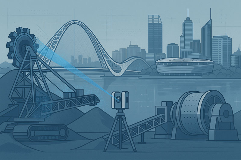
3D LiDAR Scanning Solutions Australia: Capturing Engineering-Grade Accuracy for Mining, Industrial & Infrastructure Projects
3D LiDAR scanning has rapidly become one of Australia’s most valuable engineering tools — and for good reason. From mining CHPPs to power stations, manufacturing plants, processing facilities, marine infrastructure, and complex brownfield upgrades, LiDAR delivers accuracy, clarity, and reliability that traditional measurement methods simply can’t match.
Across Australia’s most demanding industrial regions — the Hunter Valley, Bowen Basin, Pilbara, Mount Isa, Central Coast, Sydney, Adelaide, and beyond — Hamilton By Design provides engineering-grade 3D LiDAR scanning, mechanical design, and full digital-engineering workflows that help clients minimise shutdown duration, eliminate rework, and make better decisions.
This page explains what 3D LiDAR scanning is, why it matters, and how it delivers real, measurable benefits to Australian mining, industrial, and manufacturing operations.
What Is 3D LiDAR Scanning?
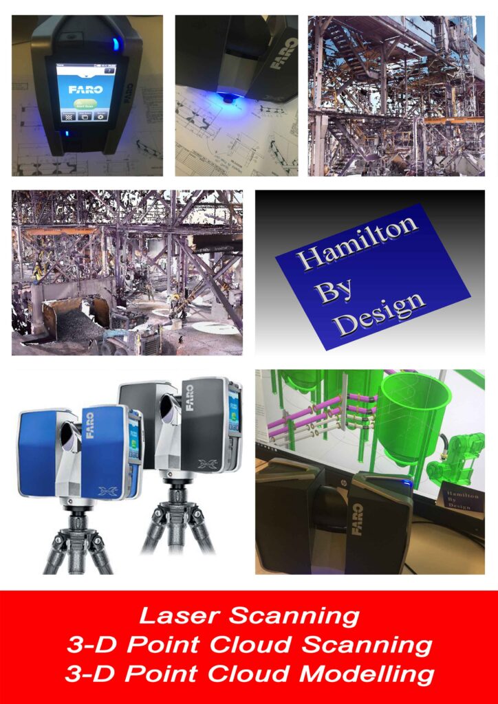
LiDAR (Light Detection and Ranging) uses laser pulses to measure millions of points per second, capturing the exact geometry of equipment, structures, and environments. The result is a high-resolution point cloud that serves as a digital replica of the asset — precise down to the millimetre.
Hamilton By Design uses FARO engineering-grade scanners delivering:
±1–2 mm accuracy
Full-colour point clouds
Safe, fast external and internal scanning
High-resolution data suitable for mechanical design and fabrication
This accuracy allows us to model steelwork, chutes, conveyors, piping, tanks, equipment frames, building interiors, structural interfaces, and entire wash plants with confidence.
Why Australian Industries Are Turning to LiDAR
Australia’s mining, energy, and industrial sectors face unique pressures: tight shutdown windows, ageing infrastructure, safety constraints, limited access, and the constant demand for more accurate data.
LiDAR scanning solves these challenges by offering:
1. Fast, Safe, Non-Contact Measurement
No climbing into hazardous areas. No lengthy tape measurements. No assumptions.
LiDAR captures everything from a safe distance — ideal for CHPPs, crushing circuits, transfer towers, power stations, and restricted plant rooms.
2. Zero Guesswork in Brownfield Engineering
Brownfield sites are messy. Nothing is straight, square, or built to the original drawing anymore.
With LiDAR:
Misalignment is captured
Deformation is visible
Corrosion and sag are measurable
Legacy drawings can be validated or corrected
This drastically reduces design error across upgrades, fabrication, and shutdown works.
3. Millimetre-Accurate 3D Models for Fabrication
After scanning, Hamilton By Design converts the point cloud into:
SolidWorks 3D models
GA drawings
Fabrication drawings
DXF profiles
Shop-ready detail packs
Fabricators love it because parts fit the first time, and rework is almost eliminated.
4. Better Shutdown Planning
LiDAR scanning provides clear digital visibility of:
Access routes
Lifting paths
Structural constraints
Tie-in locations
Clash points
This leads to safer, faster, more predictable shutdown execution.
5. Digital Twins for Long-Term Asset Management
A structured point cloud becomes a digital baseline for future planning. Clients use it for:
Condition monitoring
Deviation tracking
Long-term upgrade planning
Documentation for compliance
It builds engineering resilience into the asset lifecycle.
Industries We Support Across Australia
Hamilton By Design delivers LiDAR scanning and mechanical engineering solutions nationwide, supporting:
Mining & Heavy Industry
CHPPs
Coal handling plants
Hard-rock processing facilities
Underground & surface operations
Conveyors, chutes, crushers, screen houses
Energy & Utilities
Power stations
Turbine halls
Boiler houses
Substations
Cooling water systems
Manufacturing & Industrial
Plants and factories
Production lines
Warehouses
Material-handling systems
Data Centres & Infrastructure
Fit-out scans
MEP coordination
Expansion planning
Brownfield integration
Wherever precision and clarity are required, LiDAR scanning adds value.
Our Digital Engineering Workflow
Hamilton By Design integrates LiDAR scanning into a full project lifecycle:
On-site LiDAR scan using FARO engineering-grade equipment
Processing in FARO Scene to create a clean, structured point cloud
Import into SolidWorks for modelling of required geometry
3D modelling & mechanical design
Clash detection & feasibility checks
3DEXPERIENCE reviews with clients
Fabrication drawings, DXF files, and shop packs
Handover + digital twin for future works
This ensures absolute clarity from the first scan to the final signed-off drawing.
Benefits for Australian Projects
✔ Parts fit first time
✔ Shutdown durations reduced
✔ Fabricators receive complete, accurate information
✔ Safer site access with fewer high-risk activities
✔ Eliminates rework, delays, and measurement errors
✔ Enhances engineering collaboration
✔ Reduces total project cost
LiDAR scanning isn’t just a measurement method — it’s a competitive advantage.
Why Choose Hamilton By Design
Over a decade of experience in heavy industry
Extensive CHPP and mining plant expertise
SolidWorks Simulation, FEA, and advanced modelling capability
Fast mobilisation across Australia
Detailed, fabrication-ready deliverables
LinkedIn-trusted and industry-proven
Engineering accuracy at every step
For clients across the Hunter Valley, Bowen Basin, Pilbara, NSW, QLD, WA, and SA — we offer scalable, high-precision digital engineering that delivers reliability and confidence.
Ready to Start Your Project?
Hamilton By Design offers 3D LiDAR scanning anywhere in Australia, from mine sites to manufacturing plants to data centres.
If you’re planning:
an upgrade
a shutdown
a brownfield expansion
a feasibility study
or an equipment replacement
…LiDAR scanning is the smartest starting point.
Contact us today to book a site scan or request a proposal.
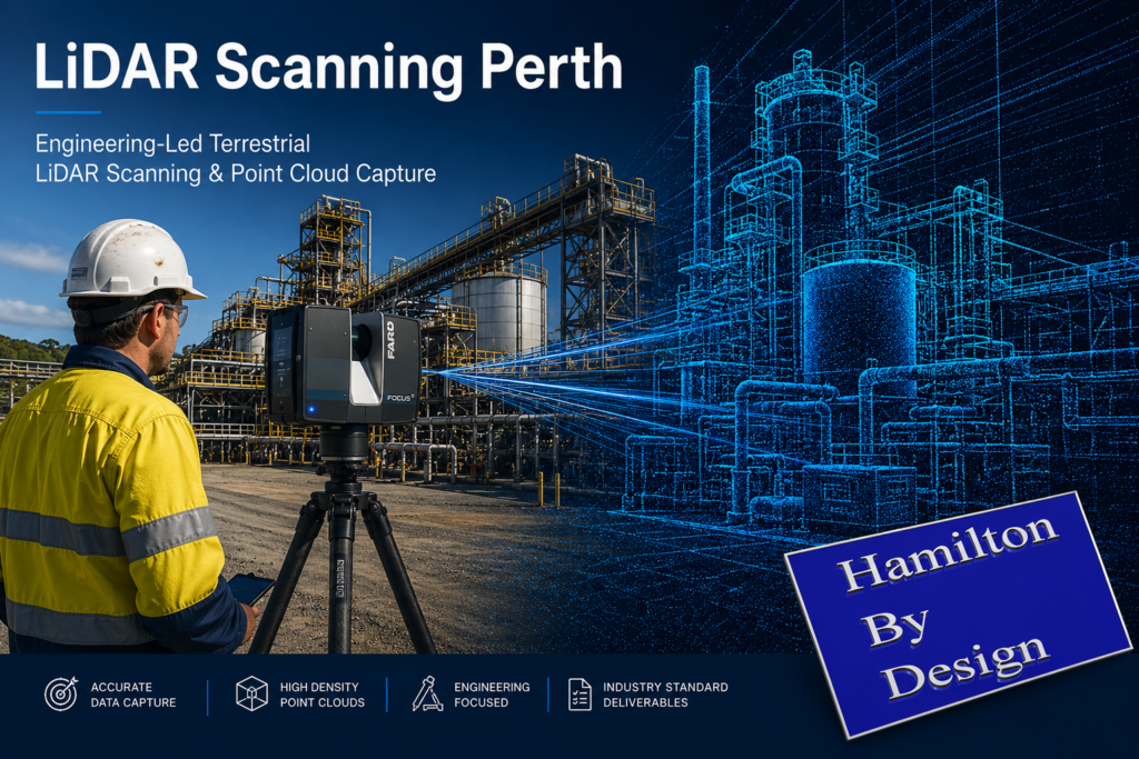
Engineering-Grade Terrestrial LiDAR Scanning Services Across Perth and Western Australia
Hamilton By Design delivers high-precision 3D LiDAR scanning for Perth-based engineering teams, fabrication workshops and remote WA mining operations. Whether your project is in Welshpool, the Pilbara, Kalgoorlie, or anywhere across regional WA, our 3D scans provide the accurate as-built data you need to design, model and install with confidence.
LiDAR scanning has become one of the most effective methods for capturing accurate three-dimensional information from existing industrial facilities, infrastructure assets and commercial buildings. By using terrestrial laser scanning technology, millions of survey-grade measurement points can be collected in a matter of hours, creating a highly detailed digital representation of real-world environments.
Hamilton By Design provides engineering-led LiDAR scanning services throughout Perth and Western Australia, supporting mining operations, mineral processing facilities, manufacturing plants, infrastructure projects and complex industrial environments.
Unlike traditional measurement methods that rely on individual dimensions and manual site sketches, terrestrial LiDAR captures complete environments, enabling project teams to work from measured reality rather than assumptions.
The resulting point cloud data provides an accurate digital record of existing conditions and can be used to support asset management, engineering studies, refurbishment projects, shutdown planning, construction verification and digital transformation initiatives.
What Is LiDAR Scanning?
LiDAR (Light Detection and Ranging) is a measurement technology that uses laser pulses to determine the position of objects and surfaces within an environment. By recording the time taken for each laser pulse to travel to a surface and return to the scanner, millions of highly accurate measurements can be captured and converted into a three-dimensional digital representation of the real world.
Modern terrestrial LiDAR scanners can collect hundreds of thousands of measurements per second, enabling large industrial facilities, processing plants, infrastructure assets and commercial buildings to be documented quickly and accurately.
The resulting dataset is commonly referred to as a point cloud. Each point represents a measured location in three-dimensional space and collectively forms a detailed digital record of the scanned environment.
For industrial and engineering projects, LiDAR scanning provides a practical alternative to traditional tape measures, manual surveys and incomplete legacy drawings. Rather than measuring individual dimensions, entire facilities can be captured in a single coordinated dataset, allowing project teams to review, analyse and measure existing conditions long after the site visit has been completed.
LiDAR scanning is now widely used throughout mining, mineral processing, manufacturing, power generation, water treatment, transport infrastructure and commercial construction projects where accurate existing-condition information is essential for successful project delivery.
Terrestrial LiDAR scanners are positioned at multiple locations throughout a site to capture measurements from different viewpoints. During each scan, the instrument emits laser pulses that reflect from surrounding surfaces and return to the scanner. These measurements are combined with angular position information to determine the precise three-dimensional location of each point.
Because industrial facilities often contain equipment, structures, pipework and other objects that can obstruct the line of sight, multiple scan positions are typically required to capture the complete environment. The individual scans are then aligned and registered together to create a unified point cloud representing the entire site.
Modern LiDAR systems can capture millions of measurements within a relatively short period, allowing large areas to be documented efficiently while maintaining a high level of detail. Colour imagery can also be captured during the scanning process, providing additional visual context for project teams reviewing the data.
Once registration and quality checks have been completed, the resulting point cloud can be viewed, measured and analysed using specialised software platforms. Engineers, designers, asset owners and project managers can then access accurate existing-condition information without requiring repeated site visits.
This process creates a digital record of the facility at the time of capture, providing valuable information for refurbishment projects, shutdown planning, asset management, engineering studies, construction verification and future modifications.
Benefits of LiDAR Scanning for Industrial Facilities
Industrial facilities are constantly evolving. Equipment is upgraded, pipework is rerouted, structures are modified and assets are replaced over time. In many cases, existing drawings no longer accurately represent current site conditions, creating challenges for maintenance teams, engineers, contractors and asset owners.
LiDAR scanning provides a reliable method of capturing accurate existing-condition information before project work begins. By collecting millions of measurement points across an entire facility, project teams gain access to a detailed digital representation of the site that can be reviewed and measured long after fieldwork has been completed.
One of the primary benefits of LiDAR scanning is the reduction in repeat site visits. Rather than returning to site to confirm dimensions or investigate potential clashes, teams can often access the required information directly from the registered point cloud.
LiDAR scanning can also improve project planning and coordination. Designers, engineers and stakeholders can review existing conditions using a common dataset, helping to identify spatial constraints, access requirements and potential conflicts before fabrication or construction activities commence.
For operational facilities, data capture can often be completed while minimising disruption to production activities. This allows project teams to obtain accurate site information without the extended downtime that may be associated with traditional measurement methods.
Additional benefits of LiDAR scanning include:
Rapid capture of complex environments
Improved visibility of existing conditions
Reduced reliance on legacy drawings
Enhanced project planning and coordination
Better understanding of spatial relationships
Reduced risk of measurement errors
Improved documentation of assets and infrastructure
Support for digital engineering and asset management initiatives
As industrial facilities continue to adopt digital engineering workflows, LiDAR scanning is increasingly becoming a foundational tool for capturing reliable information that supports decision-making throughout the asset lifecycle.
LiDAR Scanning for Mining and Resources Projects
The mining and resources sector operates some of the most complex industrial facilities in Australia. Processing plants, conveyors, crushers, transfer stations, stockpile systems, workshops, tank farms, smelters and materials handling infrastructure often undergo continuous modification throughout their operational life.
Accurate existing-condition information is essential when planning upgrades, shutdowns, equipment replacements and brownfield expansion projects. Unfortunately, many sites rely on legacy drawings that may no longer accurately reflect the current configuration of the facility.
Terrestrial LiDAR scanning provides a practical solution by capturing the actual physical environment as it exists on site. Millions of measurement points can be collected across plant areas, creating a detailed digital record that supports engineering, maintenance and asset management activities.
Within mining and resource operations, LiDAR scanning is commonly used to document:
Processing plants and beneficiation facilities
Conveyors and materials handling systems
Crushers, screens and transfer stations
Smelters and refining operations
Structural steel and access platforms
Pipe racks and process services
Tank farms and storage facilities
Workshops and maintenance infrastructure
Shutdown and turnaround project areas
Brownfield expansion locations
The resulting point cloud provides project teams with a reliable source of information for planning and decision-making. Existing conditions can be reviewed before personnel return to site, helping improve project preparation and reducing uncertainty during design and construction activities.
LiDAR scanning is particularly valuable where access is difficult, production schedules are constrained or facilities have undergone numerous modifications over time. By capturing measured reality, project teams can work from current site information rather than assumptions or outdated documentation.
Across Western Australia, LiDAR scanning is increasingly supporting mining, mineral processing, oil and gas, bulk materials handling and heavy industrial facilities as organisations continue to adopt digital engineering and asset management practices.
Point Cloud Registration and Quality Assurance
The quality of a LiDAR scanning project is determined not only by the data collected in the field but also by the processes used to align, verify and validate that information after capture. Individual scans must be accurately combined to create a single coordinated dataset that represents the facility as a whole.
This process is known as point cloud registration. During registration, overlapping scan positions are aligned using common reference points and geometric features captured throughout the scanning process. The objective is to ensure that all scans occupy the correct position within the three-dimensional environment and accurately represent the physical site conditions.
For industrial facilities, registration is particularly important because projects often involve multiple scan locations, complex structures and extensive plant areas. Without proper registration, measurement accuracy can be reduced and inconsistencies may be introduced into the final dataset.
Quality assurance procedures are typically undertaken throughout both fieldwork and data processing activities. These checks may include:
Verification of scan coverage
Review of registration quality reports
Validation of overlapping scan positions
Identification of missing or obscured areas
Assessment of point cloud consistency
Confirmation of coordinate systems where applicable
Review of deliverable requirements
By applying structured registration and quality assurance processes, project teams can have greater confidence that the resulting point cloud accurately reflects the conditions present at the time of capture.
A well-registered point cloud provides a reliable foundation for future project activities including asset documentation, engineering studies, refurbishment planning, digital engineering workflows and construction verification. It also enables stakeholders to extract measurements, review spatial relationships and investigate site conditions without relying solely on field observations.
As industrial facilities become increasingly reliant on digital information, point cloud registration and quality assurance remain essential components of delivering accurate, dependable and usable LiDAR scanning data.
Engineering-Grade Accuracy and Data Validation
Accuracy is one of the primary reasons organisations choose terrestrial LiDAR scanning for industrial, infrastructure and asset management projects. The ability to capture millions of measured points across an environment provides project teams with a detailed representation of existing site conditions that can support planning, design and decision-making activities.
However, achieving reliable results requires more than simply operating a scanner. The quality of the final point cloud is influenced by factors including scan planning, equipment selection, site conditions, registration workflows and quality assurance procedures.
Engineering-grade LiDAR scanning focuses on capturing data that is suitable for practical project applications. This begins with identifying the objectives of the survey and understanding the level of detail required. Different projects may require different scanning resolutions, coverage areas and validation procedures depending on how the data will ultimately be used.
Several factors can influence data quality, including:
Distance between the scanner and the target
Surface characteristics and material reflectivity
Environmental conditions during capture
Line-of-sight restrictions
Plant congestion and equipment density
Scan position planning
Registration quality between scans
Industrial facilities can present additional challenges due to elevated structures, confined spaces, complex pipework arrangements and restricted access areas. Effective scan planning helps minimise these challenges and improves overall dataset quality.
Data validation is an important part of the workflow and helps confirm that the point cloud accurately represents the physical environment. Validation activities may include reviewing registration reports, checking critical dimensions, assessing coverage and confirming that project-specific requirements have been achieved.
It is also important to recognise that no measurement technology is entirely free from limitations. Areas hidden from the scanner’s line of sight, highly reflective surfaces and inaccessible locations may require additional scan positions or supplementary verification methods. Understanding these limitations helps ensure realistic project expectations and reliable outcomes.
When supported by appropriate planning, registration and quality assurance procedures, terrestrial LiDAR scanning provides a dependable source of existing-condition information for industrial facilities, mining operations, infrastructure assets and complex engineering environments.
As digital engineering and asset management practices continue to evolve, accurate and validated point cloud data is becoming an increasingly important resource for organisations seeking to make informed decisions based on measured reality rather than assumptions.
Point Cloud Deliverables and Data Formats
One of the advantages of terrestrial LiDAR scanning is the flexibility of the data that can be generated and shared with project stakeholders. The information collected during scanning can be processed into a range of deliverables depending on project objectives, software requirements and intended workflows.
The primary output of a LiDAR scanning project is typically a registered point cloud. This dataset contains millions of measured points representing the surfaces and geometry of the scanned environment. Point clouds can be viewed, measured and analysed using a variety of industry-standard software platforms.
Depending on project requirements, point cloud data may be delivered in formats such as:
E57
RCP
RCS
LAS
XYZ
PTS
PTX
These formats allow owners, engineers, consultants and contractors to access and utilise the captured information within their preferred software environment.
Point cloud data can support a wide range of activities including:
Existing-condition documentation
Asset management
Engineering studies
Refurbishment planning
Construction verification
Shutdown planning
Clash detection
Digital engineering workflows
Digital twin development
In addition to point cloud deliverables, project teams may use the captured data to generate drawings, models and visualisations that assist with planning and communication. The level of detail required will depend on the intended use of the information and the objectives of the project.
An important advantage of maintaining point cloud datasets is that measurements can often be extracted after the site visit has been completed. This allows stakeholders to review dimensions, investigate site conditions and obtain additional information without necessarily returning to the field.
As organisations continue to adopt digital engineering and asset management practices, LiDAR-generated datasets are becoming an increasingly valuable source of information for understanding, documenting and managing existing assets throughout their lifecycle.
By providing accurate and accessible digital representations of real-world environments, LiDAR scanning helps establish a foundation for informed decision-making across planning, design, operations and maintenance activities.
LiDAR Scanning Applications Across Western Australia
Western Australia is home to some of the world’s largest mining, processing, manufacturing and infrastructure assets. From metropolitan Perth through to the Pilbara, Goldfields and South West regions, organisations are increasingly adopting LiDAR scanning technologies to improve the way existing assets are documented, maintained and upgraded.
LiDAR scanning is particularly well suited to environments where accurate existing-condition information is critical for planning, engineering, construction and asset management activities. By capturing millions of measurement points, facilities can be documented quickly and accurately, providing stakeholders with a reliable digital representation of the physical environment.
Across Western Australia, LiDAR scanning is commonly applied within:
Mining Operations
Mining facilities often contain extensive materials handling systems, processing infrastructure, workshops, storage facilities and supporting assets. LiDAR scanning can assist with documenting existing conditions, planning upgrades and supporting brownfield expansion projects while reducing reliance on outdated drawings and manual measurements.
Mineral Processing Facilities
Mineral processing plants are continuously evolving as equipment is upgraded, replaced or modified to improve performance. LiDAR scanning enables plant operators and project teams to capture current site conditions before undertaking engineering studies, shutdown activities or capital projects.
Refineries and Smelters
Refineries and smelting operations contain complex networks of process equipment, pipework, structural steel and access systems. Accurate digital records can support maintenance planning, asset management initiatives and future project development by providing a detailed understanding of the existing facility layout.
Ports and Bulk Materials Handling Infrastructure
Western Australia’s export industries rely on extensive bulk materials handling infrastructure including conveyors, transfer stations, stockpile facilities and ship-loading systems. LiDAR scanning can assist with documenting these assets and supporting maintenance, refurbishment and expansion activities.
Industrial Manufacturing Facilities
Manufacturing facilities frequently require equipment upgrades, production line modifications and plant optimisation projects. LiDAR scanning provides a comprehensive record of existing conditions that can support planning and project coordination activities.
Commercial and Institutional Assets
In addition to industrial facilities, LiDAR scanning is increasingly used to document commercial buildings, hospitals, educational campuses, transport infrastructure and public facilities. Accurate digital records can support refurbishment projects, asset management programs and long-term maintenance planning.
Hamilton By Design supports LiDAR scanning projects throughout Perth and Western Australia, including Kwinana, Pinjarra, Wagerup, Bunbury, Geraldton, Kalgoorlie, Port Hedland, Karratha and the Pilbara region. Our engineering-led approach combines practical industrial experience with advanced reality capture technologies to deliver accurate and reliable digital representations of existing assets.
As organisations continue to invest in digital engineering, asset management and operational efficiency, LiDAR scanning is becoming an increasingly valuable tool for understanding existing conditions and supporting informed decision-making across the entire asset lifecycle.
Why Choose Hamilton By Design for LiDAR Scanning Perth
Successful LiDAR scanning projects require more than the ability to operate a laser scanner. The real value lies in understanding how the captured information will be used and ensuring that the resulting dataset supports project objectives.
Hamilton By Design combines terrestrial LiDAR scanning technology with practical engineering, drafting and industrial experience. This enables us to understand the challenges commonly encountered within mining operations, mineral processing facilities, manufacturing plants, infrastructure assets and complex industrial environments.
Our approach focuses on capturing information that supports informed decision-making. By understanding project requirements before fieldwork begins, scan coverage, resolution and deliverables can be aligned with the intended use of the data, helping project teams obtain information that is relevant, accurate and practical.
We regularly support projects involving:
Mining and resource operations
Mineral processing facilities
Refineries and smelters
Materials handling systems
Manufacturing facilities
Infrastructure assets
Commercial and institutional buildings
Brownfield expansion projects
Asset management initiatives
Digital engineering programs
Hamilton By Design utilises professional terrestrial LiDAR scanning equipment and industry-standard processing workflows to produce registered point cloud datasets suitable for a wide range of engineering, operational and asset management applications.
Beyond data capture, our team understands how point cloud information is commonly used throughout the project lifecycle. This broader understanding assists in identifying critical areas for capture, supporting quality outcomes and ensuring project stakeholders receive information that can be effectively integrated into existing workflows.
We support projects throughout Perth and Western Australia, including regional mining and industrial locations where accurate existing-condition information is essential for planning, maintenance, engineering and capital works activities.
As organisations continue to adopt digital engineering and asset management practices, LiDAR scanning is becoming an increasingly important tool for capturing measured reality and establishing a reliable foundation for future project activities.
Hamilton By Design remains committed to providing engineering-led LiDAR scanning services that deliver accurate, dependable and practical digital information for industrial, infrastructure and commercial projects across Western Australia.
Frequently Asked Questions
What is LiDAR scanning?
LiDAR (Light Detection and Ranging) is a technology that uses laser pulses to measure the position of objects and surfaces within an environment. The collected measurements are combined to create a highly detailed three-dimensional representation known as a point cloud. LiDAR scanning is widely used to document existing facilities, infrastructure and industrial assets.
How accurate is terrestrial LiDAR scanning?
Accuracy depends on the equipment used, scan planning, site conditions and registration processes. Modern terrestrial LiDAR scanners are capable of capturing highly accurate measurements suitable for engineering, asset management and industrial applications. Quality assurance and data validation procedures are important to ensure reliable project outcomes.
What is a point cloud?
A point cloud is a collection of millions of individual measurement points captured during the scanning process. Each point represents a location in three-dimensional space. When combined, these points create a digital representation of the scanned environment that can be viewed, measured and analysed using specialised software.
What deliverables can be provided?
LiDAR scanning projects can produce a variety of deliverables depending on project requirements. Common outputs include registered point clouds, E57 files, RCP files, RCS files, LAS files and other industry-standard formats that can be used within engineering, construction and asset management workflows.
Can LiDAR scanning be completed during plant shutdowns?
Yes. LiDAR scanning is frequently used during shutdowns, maintenance outages and capital works projects. Capturing accurate existing-condition information before work begins can help project teams plan modifications, identify potential constraints and improve overall project coordination.
How long does a LiDAR scanning project take?
Project duration depends on the size and complexity of the facility being captured. Small areas may be completed within a single day, while large industrial facilities, processing plants or mining operations may require multiple days of fieldwork and additional processing time to register and validate the point cloud data.
Do you provide LiDAR scanning services outside Perth?
Yes. Hamilton By Design supports projects throughout Western Australia, including mining, industrial and infrastructure locations. Services can be provided across Perth, Kwinana, Pinjarra, Wagerup, Bunbury, Geraldton, Kalgoorlie, Port Hedland, Karratha and the Pilbara region, as well as interstate locations where required.
What industries commonly use LiDAR scanning?
LiDAR scanning is used across a wide range of industries including mining, mineral processing, manufacturing, oil and gas, infrastructure, utilities, water treatment, ports, transport, commercial construction and asset management. The technology provides accurate existing-condition information that can support planning, maintenance, engineering and operational activities.
Why is LiDAR scanning becoming more popular?
Many organisations are adopting digital engineering and asset management practices that require reliable existing-condition information. LiDAR scanning enables facilities to be captured quickly and accurately, providing a digital record that can support decision-making throughout the lifecycle of an asset.
Can point cloud data be used in engineering software?
Yes. Point cloud datasets can typically be imported into a range of engineering, design and modelling software platforms. This allows project teams to reference existing site conditions, extract measurements and integrate scanned information into digital engineering workflows.
Discuss Your LiDAR Scanning Project
Whether you are planning a plant upgrade, documenting existing assets, preparing for a shutdown, or investigating digital engineering opportunities, accurate existing-condition information is the foundation of successful project delivery.
Hamilton By Design provides engineering-led terrestrial LiDAR scanning services throughout Perth and Western Australia, supporting mining operations, processing facilities, industrial plants, infrastructure assets and commercial projects.
Our team can help determine the most suitable scanning approach, required deliverables and level of detail needed to achieve your project objectives.
Complete the enquiry form below and tell us about your project requirements.
A member of our team will review your information and contact you to discuss scope, site access, deliverables, project timing and any technical requirements.
Typical Information to Include
Project location
Facility or asset type
Approximate area to be scanned
Required deliverables
Project timeframe
Site access requirements
Shutdown or outage windows
Any existing drawings or reference information
Need advice before requesting a quotation?
We are happy to discuss your project requirements and provide guidance on scanning methodology, deliverables and project planning before work commences.
Ready for 3D Scanning in Perth or WA?
Speak to our engineering team about your project, shutdown or scanning requirements.
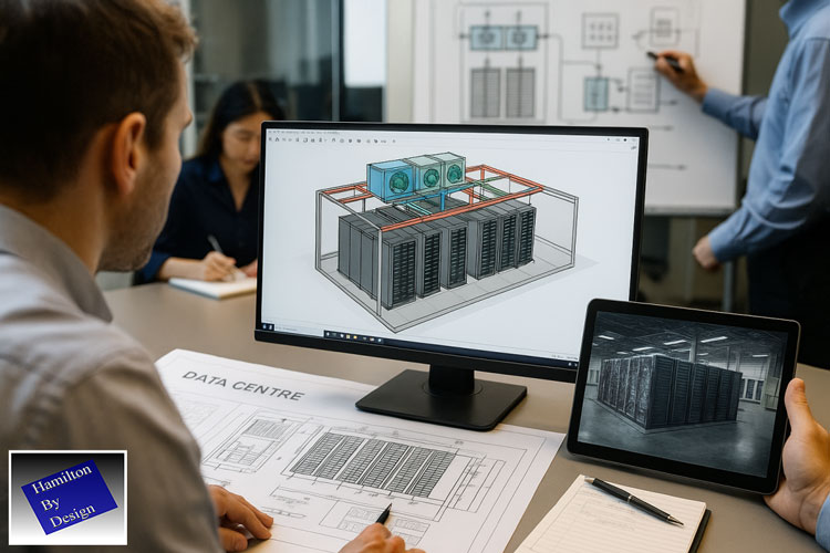
Australia’s digital infrastructure is expanding rapidly — and so is the demand for Data Centre Design that delivers reliability, performance, and scalability.
At Hamilton By Design, our team transforms concept and intent into manufacturable, modular, and compliant systems.
We specialise in Data Centre Design, mechanical and structural systems engineering, and fabrication-ready modelling that connect advanced engineering with real-world delivery. Every project is supported by traceable documentation, detailed verification, and hands-on manufacturing experience — ensuring confidence from start to finish.
Our Team Understands the Pressures of Data Centre Design
Our team understands that Data Centre Design is not just about drawings — it’s about precision, coordination, and absolute reliability.
We recognise the pressures of delivering mission-critical infrastructure: tight timelines, technical complexity, regulatory compliance, and no margin for downtime. That’s why our approach to Data Centre Design is built on clarity, accountability, and engineering confidence.
By combining advanced modelling with practical fabrication knowledge, our team ensures every interface aligns, every system performs, and every project milestone builds trust. Our goal is to make the journey from design to delivery simpler, faster, and more certain.
Our Integrated Data Centre Design Offerings
1. Modular & Prefabricated Systems
Factory-Built Reliability Our team delivers modular systems that make Data Centre Design faster, safer, and more predictable. We design and fabricate plug-and-play assemblies — cooling skids, racking frames, HVAC supports, and power-distribution modules — engineered for repeatability and verified off-site before installation. From design to deployment — built locally.
2. Mechanical & Structural Systems Engineering
Engineered for the Workshop Our team converts design concepts into fabrication-ready 3D models, optimised for Data Centre Design precision and installation accuracy. Using LiDAR scanning and FEA validation, we eliminate tolerance issues and ensure perfect fit-up on site. Designs that build themselves.
3. Energy & Water Integration
Engineered Sustainability Modules Modern Data Centre Design requires efficient energy and cooling systems. Our team develops renewable-ready modules, including battery enclosures, hybrid cooling loops, and water-recycling assemblies. These systems improve energy performance, reduce water consumption, and support sustainability targets. Turning sustainability into engineered reality.
4. Retrofit & Upgrade Engineering
Upgrades Without Downtime Our team delivers Data Centre Design solutions for live facilities needing upgrades or expansion. Through LiDAR scanning and modular fabrication, we create retrofit systems that fit precisely within existing structures — enabling capacity growth without disrupting operations.
Upgrades engineered to fit.
5. Documentation & Compliance
Audit-Ready Fabrication In Data Centre Design, compliance and traceability are critical. Our team provides complete documentation: material certificates, weld maps, QA records, and 3D-model traceability. Processes align with ISO 9001, AS 1554, and AS 4100, ensuring full accountability across every project phase. Every weld certified. Every drawing traceable.
Why Organisations Choose Hamilton By Design for Data Centre Design
Challenge
Our Response
Tight construction schedules
Off-site modular fabrication and verified fit-ups reduce rework and on-site time.
Design-to-fabrication disconnects
Integrated SolidWorks modelling, LiDAR scanning, and FEA deliver workshop-ready accuracy.
Risk and compliance pressures
Documented QA, full traceability, and standards-aligned processes protect project integrity.
Retrofit constraints
Modular upgrade solutions minimise downtime and maintain performance.
Sustainability goals
Energy-efficient and water-recycling modules lower PUE and environmental impact.
Partner With Hamilton By Design
Whether you are developing a new hyperscale facility or upgrading an existing site, Hamilton By Design provides Data Centre Design solutions that combine engineering precision, modular flexibility, and compliance confidence.
Our team doesn’t just fabricate — it engineers confidence into every component.
Contact our team today to discuss modular systems, retrofit upgrades, or compliant fabrication for your next Data Centre Design project.
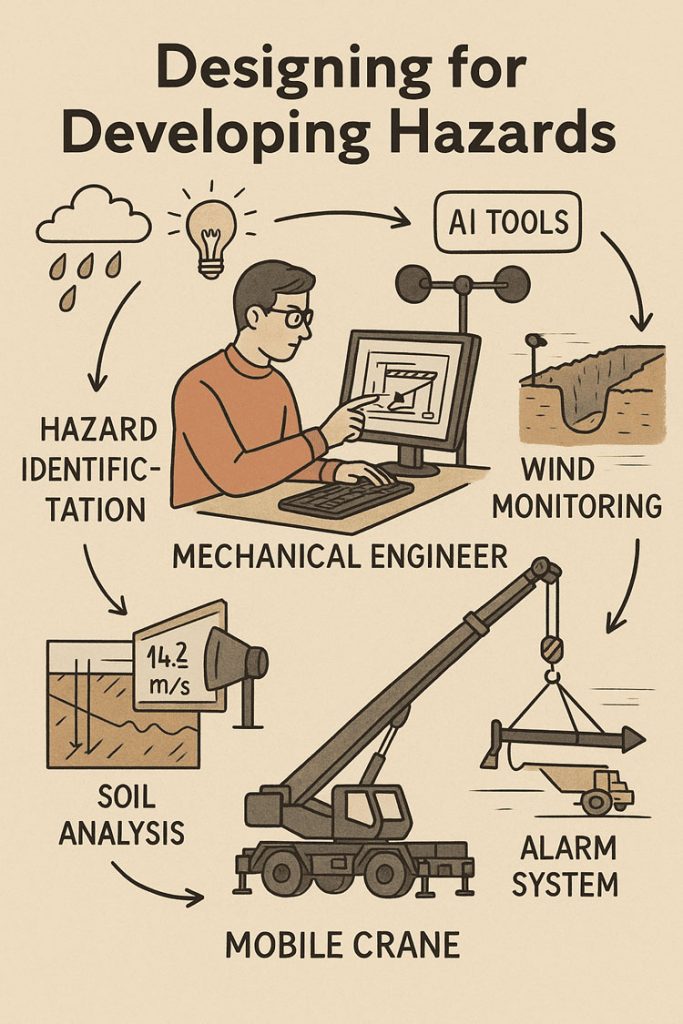
Designing for Developing Hazards: Lessons from the Derrimut Crane Collapse
Crane accidents are among the most visible reminders of the risks inherent in construction. The collapse of a crane at a data centre site in Derrimut, Melbourne, brought attention once again to the vulnerability of temporary lifting structures. While formal investigations are still underway, and no conclusions should be drawn prematurely, the event provides a valuable opportunity for reflection within the engineering community.
This article considers the collapse not as an isolated failure but as a case study in hazard identification. In particular, it highlights how mechanical engineers must adapt from a static, design-phase view of risk to a dynamic, real-time approach to hazard monitoring. Wind, soil stability, and load conditions are well-known hazards. But with modern tools — including LiDAR scanning for obstacle detection — engineers can move toward a future where developing hazards are continuously tracked, anticipated, and controlled.
From Hazard Identification to Live Hazard Monitoring
Hazard identification has traditionally been a design-phase process: engineers anticipate risks, apply safety factors, and create conservative margins. This remains essential. Yet the Derrimut collapse illustrates the limits of a static model in a dynamic environment.
Cranes are exposed to evolving hazards:
Wind gusts that change minute by minute.
Soil stability that shifts with rainfall, excavation, or groundwater.
Obstacles such as power lines or nearby structures, which can create cascading risks if struck.
Load dynamics, including swinging or sudden movement.
What is needed is a transition from hazard identification to hazard monitoring: a continuous loop where design assumptions are validated against real-time data, and where developing risks are detected before they become failures.
Wind Hazards: Predicting the Unpredictable
Wind is a leading cause of crane collapses. Engineers know the mathematics: pressure rises with the square of velocity. A 50 km/h gust exerts twice the force of a 35 km/h breeze.
Most cranes today are fitted with anemometers and alarms, but these are often basic: a single reading at a single point, with alarms sounding when preset thresholds are exceeded. This approach can miss:
Local gust variability along a long jib.
Interaction with crane orientation (wind hitting the broadside is more critical than aligned wind).
Forecasted conditions that could deteriorate within minutes.
Next-generation wind monitoring could include:
Multi-point sensor arrays on cranes.
Integration with Bureau of Meteorology gust forecasts.
AI models predicting when risk thresholds will be exceeded, not just reporting when they are crossed.
Automatic crane repositioning to minimise wind exposure.
This transforms alarms from reactive to predictive — the difference between warning after a hazard is present and anticipating before it materialises.
Soil Hazards: Stability Under Load
Ground conditions are another silent but critical hazard. Outriggers may impose hundreds of kilonewtons on pads, meaning even small soil weaknesses can lead to tilting or overturning.
Engineering practice already includes soil investigations: boreholes, CPT, SPT, and FEA models. But these tests capture conditions before installation, not necessarily during operation. Soil strength can change due to rainfall, groundwater shifts, or nearby excavation.
Live soil monitoring can be achieved with:
Load cells under mats to track ground reactions.
Settlement gauges to detect tilt.
Piezometers for pore pressure during rain events.
Integrated warnings when ground resistance trends downward.
This approach acknowledges soil as a living hazard that changes daily.
LiDAR and Obstacle Detection: Power Lines and Proximity Hazards
One striking feature of the Derrimut collapse was the crane’s boom striking power lines. Contact with utilities is a recurrent hazard in crane operations worldwide. While operators are trained to maintain exclusion zones, in practice visibility, fatigue, or unexpected boom movement can still lead to contact.
LiDAR scanning offers a solution.
How it works: LiDAR (Light Detection and Ranging) emits laser pulses to map surroundings in 3D with centimetre accuracy. Mounted on a crane, it can create a live digital map of nearby obstacles.
Application in cranes:
Detecting and mapping power lines, buildings, or scaffolding in the lift path.
Setting proximity alarms when a boom, hook, or load approaches a defined clearance.
Combining with wind data to predict if gusts could push the load into restricted zones.
In aviation, LiDAR and radar-based systems are standard for obstacle detection. In construction, adoption is patchy. Yet the technology exists, is cost-effective, and could dramatically reduce risks of contact with hazards like live power lines.
LiDAR’s strength lies not only in static mapping but in detecting movement — for example, when a suspended load begins to swing toward a power line due to a gust. This is a quintessential developing hazard, one that static design could never fully capture.
Integrated Hazard Dashboards
Wind, soil, and LiDAR obstacle detection all provide valuable data. But their true power lies in integration. Imagine a crane operator’s cabin equipped with a single dashboard displaying:
Wind speeds and gust forecasts, colour-coded for risk.
Soil reaction forces under each outrigger, with alerts if settlement is trending.
LiDAR mapping of nearby structures and power lines, with real-time clearance zones.
Predictive risk models showing probability of instability or contact over the next 30 minutes.
This integration mirrors aviation’s cockpit: multiple inputs fused into actionable guidance. For cranes, such systems could shift the operator’s role from reactive decision-maker to proactive risk manager.
AI as a Predictive Partner
Artificial Intelligence has a natural role in hazard monitoring:
Sensor fusion: combining wind, soil, and LiDAR inputs into coherent risk profiles.
Prediction: learning from past crane incidents to forecast when risks are likely to escalate.
Decision support: providing operators with clear options (“safe to continue lift for 20 minutes” / “halt operations — clearance margin < 1m”).
The challenge is balance. AI should not replace human oversight, but augment it. Over-reliance could create new vulnerabilities if operators become complacent. The design challenge is to build AI into systems that support human judgment rather than substitute for it.
Ethics and Engineering Responsibility
The Derrimut collapse underscores the ethical responsibility of mechanical engineers. Hazard identification is not just a design requirement; it is a matter of public safety. The profession has a duty to anticipate, detect, and control risks wherever possible.
The tools now exist to monitor developing hazards — wind sensors, soil gauges, LiDAR scanners, and AI dashboards. If lives and infrastructure can be protected through wider adoption of these tools, then the question becomes one of responsibility: should they be optional, or mandatory?
Open Questions for the Future
Would integrated live monitoring have reduced the risks at Derrimut?
Should all cranes be fitted with LiDAR obstacle detection as standard?
Do we already have enough technology, but lack regulation and enforcement?
What role should AI play in balancing predictive insight with operator autonomy?
Conclusion
The Derrimut incident remains under investigation. No conclusions can be drawn about its specific cause until findings are published. Yet as a case study, it illustrates the broader point that hazards in crane operations are dynamic. Wind, soil, obstacles, and loads evolve minute by minute.
Mechanical engineers have the tools — wind sensors, soil monitors, LiDAR scanners, integrated dashboards, and AI — to detect these developing hazards. The challenge is to move from a culture of static design assumptions to one of continuous hazard monitoring.
The ultimate professional question is this: If aviation can integrate multiple systems to monitor and predict hazards, why can’t construction do the same for cranes? And if we can, how soon will we accept the ethical responsibility to make it standard?
References and Further Reading
ISO 4301 / AS 1418 — Crane standards covering stability and wind.
ISO 12480-1:2003 — Safe use of cranes; includes environmental hazard monitoring.
WorkSafe Victoria Guidance Notes — Crane safety management.
Holický & Retief (2017) — Probabilistic treatment of wind action in structural design.
Nguyen et al. (2020) — Real-time monitoring of crane foundation response under variable soil conditions.
Liebherr LICCON — Example of integrated load and geometry monitoring.
FAA LLWAS — Aviation’s real-time wind shear alert system, model for construction.
Recent research in LiDAR obstacle detection (e.g., IEEE Transactions on Intelligent Transportation Systems) — showing LiDAR’s potential in complex environments.
Harnessing the Power of LiDAR: Revolutionizing Engineering with 3D Scanning & SolidWorks
Title: Harnessing the Power of LiDAR: Revolutionizing Engineering with 3D Scanning & SolidWorks
Introduction
At Hamilton By Design, we are committed to integrating cutting-edge technologies to enhance our engineering processes. One such technology that has transformed the landscape of design and construction is LiDAR (Light Detection and Ranging). This advanced 3D scanning tool offers unparalleled precision and efficiency, enabling us to deliver superior outcomes for our clients.
The Evolution of LiDAR Technology
LiDAR technology has come a long way since its inception in the 1960s. Initially developed for meteorological and atmospheric research, it has evolved into a versatile tool used across various industries, including civil engineering, architecture, and environmental monitoring. The integration of GPS and advancements in laser technology have significantly enhanced LiDAR’s accuracy and applicability.
Advantages of Incorporating LiDAR into Engineering
Exceptional Accuracy and Detail LiDAR systems emit laser pulses to measure distances with remarkable precision, creating high-resolution point clouds that capture intricate details of structures and terrains. This level of accuracy is crucial for tasks such as topographic mapping, structural analysis, and as-built documentation.
Efficiency in Data Collection Traditional surveying methods can be time-consuming and labor-intensive. LiDAR, on the other hand, can rapidly collect vast amounts of data, significantly reduce field time and accelerate project timelines.
Enhanced Safety and Accessibility LiDAR enables remote data collection in hazardous or hard-to-reach areas, minimizing risks to personnel. Whether it’s scanning a deteriorating structure or surveying rugged terrain, LiDAR ensures safety without compromising data quality.
Integration with BIM and Digital Twins The detailed 3D models generated by LiDAR can be seamlessly integrated into Building Information Modeling (BIM) systems, facilitating better design visualization, clash detection, and project coordination. This integration supports the creation of digital twins, allowing for real-time monitoring and maintenance planning.
Cost-Effectiveness By reducing the need for repeated site visits and minimizing errors through accurate data capture, LiDAR contributes to cost savings throughout the project lifecycle. Its efficiency translates into reduced labor costs and optimized resource allocation.
Applications in Engineering Projects
At Hamilton By Design, we’ve leveraged LiDAR technology across various projects:
Infrastructure Development: Accurate terrain modeling for road and bridge design.
Heritage Conservation: Detailed documentation of historical structures for preservation efforts.
Urban Planning: Comprehensive city modeling to inform sustainable development.
Conclusion
The integration of LiDAR 3D scanning tools into our engineering processes has revolutionized the way we approach design and construction. Its precision, efficiency, and versatility align with our commitment to delivering innovative and high-quality solutions.
As technology continues to advance, we remain dedicated to adopting tools like LiDAR that enhance our capabilities and set new standards in engineering excellence.
For more information on how Hamilton By Design utilizes LiDAR technology in our projects, visit our website at www.hamiltonbydesign.com.au.
To provide the best experiences, we use technologies like cookies to store and/or access device information. Consenting to these technologies will allow us to process data such as browsing behaviour or unique IDs on this site. Not consenting or withdrawing consent, may adversely affect certain features and functions.
Functional
Always active
The technical storage or access is strictly necessary for the legitimate purpose of enabling the use of a specific service explicitly requested by the subscriber or user, or for the sole purpose of carrying out the transmission of a communication over an electronic communications network.
Preferences
The technical storage or access is necessary for the legitimate purpose of storing preferences that are not requested by the subscriber or user.
Statistics
The technical storage or access that is used exclusively for statistical purposes.The technical storage or access that is used exclusively for anonymous statistical purposes. Without a subpoena, voluntary compliance on the part of your Internet Service Provider, or additional records from a third party, information stored or retrieved for this purpose alone cannot usually be used to identify you.
Marketing
The technical storage or access is required to create user profiles to send advertising, or to track the user on a website or across several websites for similar marketing purposes.