Mechanical Engineering | 3D Scanning | 3D Modelling
Tag: Digital twin
Digital twin refers to the creation of accurate digital representations of physical assets using real-world data. This tag brings together content showing how digital twins are developed from 3D laser scanning, LiDAR, and CAD modelling to support engineering design, analysis, asset management, maintenance, and lifecycle decision-making across industrial, infrastructure, mining, and building projects.
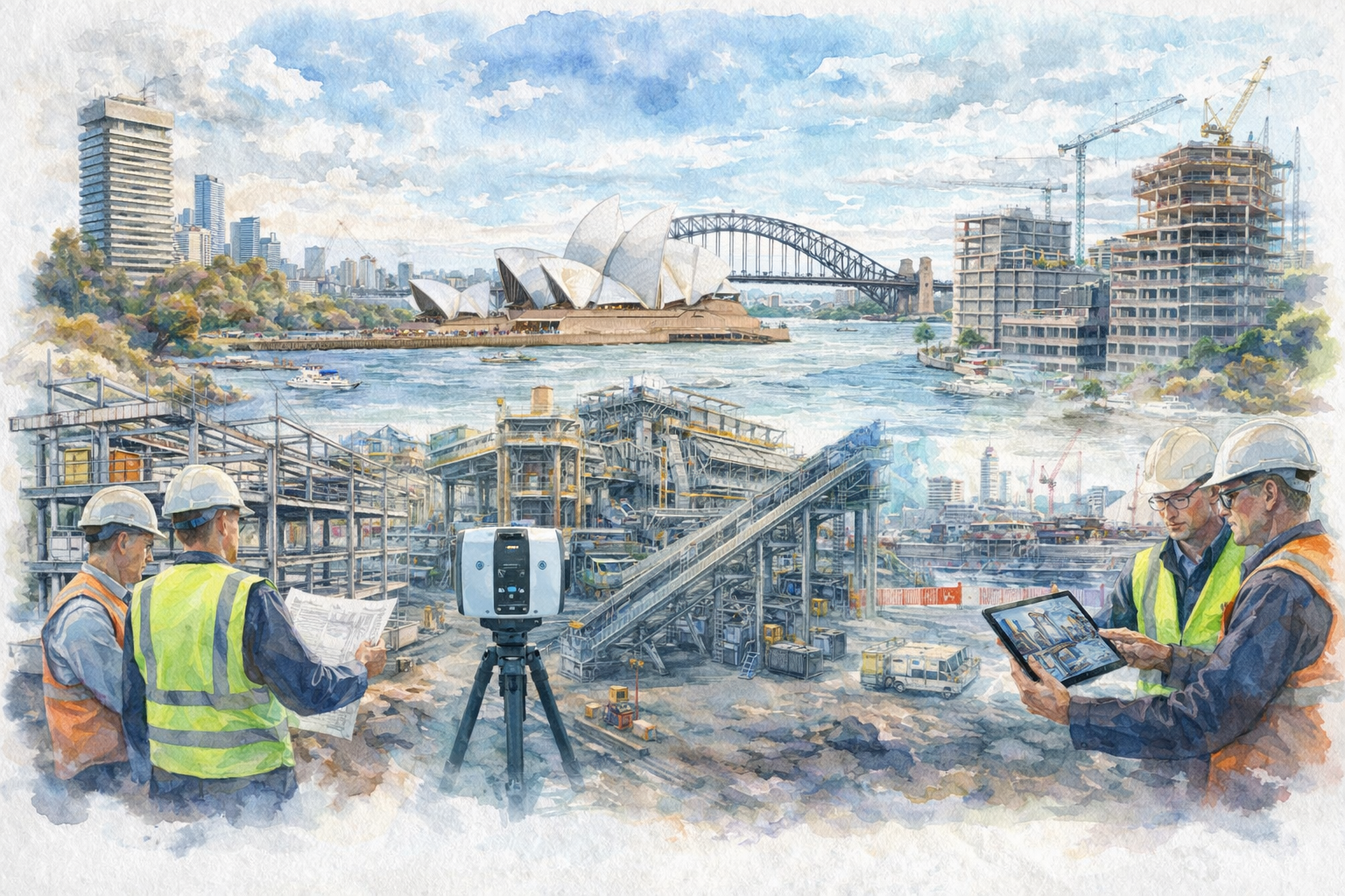
3D Laser Scanning Port Macquarie – Why Accuracy Matters for Engineering Projects
If you’re planning a plant upgrade, fabrication project, or site modification in Port Macquarie, the quality of your 3D scan data directly impacts the success of your project.
At Hamilton By Design, we provide engineering-grade 3D laser scanning services led by mechanical engineers, ensuring the data captured is not only accurate, but also suitable for real-world design, fabrication, and construction outcomes.
Not All 3D Scanning Is the Same
With the rise of low-cost scanning technology, many providers now offer handheld scanning solutions as a fast and affordable option.
While these systems can be useful for general visualisation, they often rely on SLAM-based positioning, which estimates location as the operator moves through a site.
This can introduce:
positional drift over distance
reduced dimensional accuracy
inconsistencies in large or complex environments
In many cases, these services are delivered by non-qualified operators using handheld equipment without a clear understanding of engineering requirements.
Why Mechanical Engineers Deliver Better Outcomes
3D scanning is only one part of the process. The real value comes from how the data is understood and applied.
A mechanical engineer-led scanning approach ensures:
critical areas are prioritised during capture
scan density aligns with fabrication requirements
line-of-sight limitations are identified and managed
downstream modelling and design risks are reduced
data is validated against real engineering constraints
Rather than simply collecting data, mechanical engineers focus on what the data needs to achieve.
The Risk of Handheld “Cowboy” Scanning
While handheld scanning has its place, relying solely on it — particularly when carried out by inexperienced or non-qualified operators — often leads to poor engineering outcomes.
These “fast and cheap” approaches can produce point clouds and 3D models that look correct visually but are not dimensionally reliable.
Typical issues include:
accumulated positional drift across the model
misalignment of structural and mechanical elements
missing critical geometry due to poor capture planning
inconsistent scaling across large areas
The result is 3D models that cannot be trusted for fabrication, retrofit design, or installation.
Why Tripod-Based LiDAR Scanning Is Different
Tripod-mounted LiDAR scanners capture data from fixed, controlled positions, delivering a stable and repeatable dataset.
This is critical when your project requires:
accurate tie-in points
fabrication-ready measurements
structural or mechanical design
clash detection and modelling
confidence in as-built conditions
For engineering projects, the difference is clear:
Handheld scanning shows you what it looks like. LiDAR scanning — guided by mechanical engineers — tells you what it actually is.
The Risk of Low-Accuracy Data
Choosing the wrong scanning method — or the wrong provider — can lead to:
rework during fabrication
misalignment on installation
increased project costs
delays during shutdowns or upgrades
In industrial environments, even small dimensional errors can have significant downstream impacts.
A Smarter Approach to Reality Capture
At Hamilton By Design, we take an engineering-led approach to 3D scanning, combining the right technology with real engineering expertise.
Where required, we may use multiple capture methods — but critical areas are always captured using high-accuracy LiDAR scanning guided by mechanical engineering judgement.
Supporting Port Macquarie and Regional NSW
We support clients across Port Macquarie and regional New South Wales, delivering professional 3D laser scanning services for industrial facilities, manufacturing plants, infrastructure upgrades, and mechanical and structural projects.
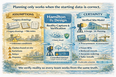
There’s a problem happening on projects across Australia right now:
Design says one thing. Site builds another.
And no one realises until it’s too late.
The Real Issue: Miscommunication Between Design and Build
It’s not that people aren’t doing their job.
It’s that the information they’re working from isn’t aligned.
Drawings don’t reflect reality
Existing plant conditions are assumed, not verified
Fabrication is based on outdated or incomplete data
Site modifications happen on the fly
👉 The result?
Rework
Delays
Cost blowouts
Frustrated teams
This is where most projects quietly bleed money.
“We Thought It Would Fit…” — The Most Expensive Words on Site
If you’ve ever heard:
“That’s not what we expected on site”
“We’ll just make it work”
“Can we modify it during install?”
You’re already in reactive mode.
And reactive mode is where projects lose control.
So What Are the Best 3D Scanning Platforms to Fix This?
Let’s be clear:
👉 It’s not just about the scanner 👉 It’s about how the data is captured, interpreted, and delivered
But here’s how the platforms stack up in the real world:
1. FARO Focus (Engineering-Grade Reality Capture)
✔ High accuracy (millimetre-level) ✔ Ideal for brownfield industrial environments ✔ Reliable for mechanical design, pipework, and structural interfaces
💡 This is where engineering-led scanning matters
Anyone can scan. Not everyone understands line-of-sight constraints, coverage, and design intent.
2. Leica RTC360 (Speed + Visualisation)
✔ Fast capture and good for large areas ✔ Strong visual workflows ✔ Great for general site documentation
⚠ But without engineering oversight, you still risk:
Missing critical geometry
Poor scan coverage
Misalignment with fabrication requirements
3. NavVis / Mobile Scanning (Speed Over Precision)
✔ Rapid walkthrough capture ✔ Useful for high-level coordination
⚠ Not suitable for:
Fabrication-level accuracy
Mechanical interfaces
Detailed engineering design
The Truth Most People Miss
The platform doesn’t fix the problem.
👉 Engineering-led scanning does.
Why Engineering-Led Scanning Changes Everything
At Hamilton By Design, we don’t just “scan a site”.
We capture it like engineers who have to design and build from it.
That means:
Understanding what needs to be modelled — and what doesn’t
Managing line-of-sight to eliminate data gaps
Delivering point clouds that actually support design decisions
Producing models and drawings that match real-world conditions
From Scan → Model → Build (No Guesswork)
When done properly, 3D scanning becomes:
✔ A single source of truth ✔ A digital twin of your site ✔ A way to align design, fabrication, and installation
No assumptions. No “we’ll fix it on site”. No disconnect.
If You’re Getting It Wrong on Site — This Is Why
It’s not your team.
It’s the gap between:
👉 What was designed 👉 And what actually exists
Fix the Gap — Not the Symptoms
If you’re serious about reducing rework, delays, and cost blowouts:
👉 Start with accurate, engineering-grade site data
Learn More
Explore how we deliver engineering-led 3D scanning in Sydney:
Reality Capture for Sydney CBD Commercial Buildings
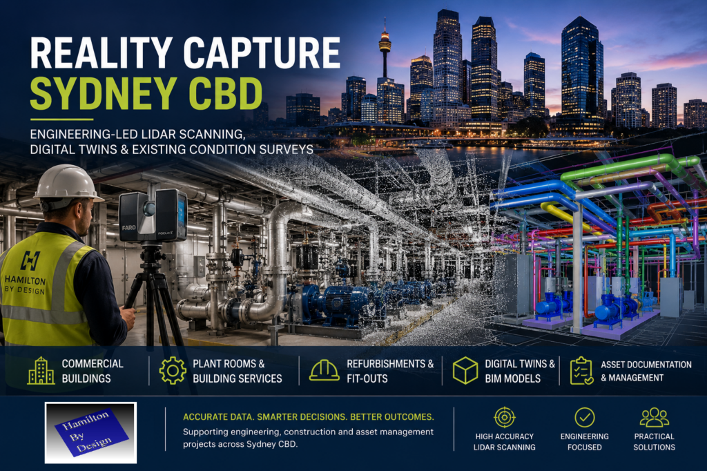
Reality Capture Sydney CBD
Sydney CBD contains some of Australia’s most complex commercial buildings, infrastructure assets and operational facilities. From high-rise office towers and hotels to hospitals, transport infrastructure and critical building services, accurate existing-condition information is essential for successful project delivery.
Hamilton By Design provides engineering-led reality capture services throughout Sydney CBD, combining terrestrial LiDAR scanning, digital engineering and practical industry experience to create accurate digital representations of existing environments.
Reality capture enables project teams to document buildings, plant rooms, building services, infrastructure and operational facilities with a level of detail that traditional measurement methods cannot achieve efficiently. The resulting data can support refurbishment projects, services upgrades, asset management programs, digital twin development, engineering design and construction planning.
By capturing measured reality rather than relying on outdated drawings or assumptions, project teams can reduce risk, improve coordination and make better-informed decisions throughout the project lifecycle.
Reality Capture for Sydney CBD Plant Rooms
Plant rooms within Sydney CBD buildings often contain decades of modifications, undocumented services and limited access for traditional measurement methods.
Reality capture provides a fast and accurate method of documenting mechanical services, pipework, structural steel, cable trays and equipment layouts before engineering design begins.
The resulting point cloud allows project teams to work from measured site conditions, reducing uncertainty and improving coordination throughout the design and construction process.
Many Sydney CBD projects involve HVAC upgrades, chiller replacements, pump room modifications, fire service upgrades and electrical infrastructure improvements where accurate existing-condition information is critical. Engineering-grade reality capture provides a reliable foundation for these projects while minimising the need for repeated site visits.
Plant Rooms, Building Services & Infrastructure
Many Sydney CBD buildings contain complex mechanical, hydraulic, electrical and fire services installed over decades of operation.
Reality capture allows these environments to be documented quickly and accurately, providing engineers and contractors with reliable information for future modifications, equipment replacements and capacity upgrades.
Applications include:
HVAC plant rooms
Chiller installations
Pump rooms
Fire services
Electrical services
Building services coordination
Vertical risers
Roof plant installations
Existing Conditions for Refurbishment Projects
Accurate existing-condition information is critical when undertaking refurbishment projects within occupied commercial buildings.
Reality capture allows consultants and contractors to understand structural constraints, service routes, equipment locations and access requirements before design begins.
This reduces project risk, improves coordination and helps minimise costly site modifications during construction.
Heritage & Existing Building Documentation
Sydney CBD contains many historically significant buildings and structures that require accurate documentation before modification or restoration works can proceed.
Reality capture provides a non-invasive method of recording existing conditions while preserving important architectural and structural details.
The resulting datasets can support heritage studies, refurbishment planning, restoration projects and long-term asset management.
Digital Twins for Building Owners
Reality capture forms the foundation of many digital twin initiatives by providing an accurate digital representation of an existing building or facility.
For Sydney CBD asset owners, digital twins can assist with:
Facility management
Future upgrades
Asset lifecycle planning
Space management
Maintenance planning
Building information management
A well-developed digital twin provides a single source of truth for future engineering, maintenance and operational decision-making.
Reality Capture Applications Across Sydney CBD
Reality capture provides value wherever accurate existing-condition information is required before design, construction or asset management decisions are made.
Commercial Office Towers
Sydney CBD contains a large concentration of commercial office buildings that undergo continual refurbishment, tenancy fit-outs and building services upgrades.
Reality capture provides accurate existing-condition information that allows project teams to understand available space, identify constraints and develop coordinated engineering solutions before work reaches site.
Building Services Upgrades
Mechanical, hydraulic, fire and electrical services within operational buildings often evolve over many years, resulting in undocumented modifications and incomplete records.
Reality capture enables engineers and contractors to accurately document existing services and develop upgrade solutions with confidence.
Hotels, Hospitals and Critical Facilities
Hotels, hospitals and critical facilities require detailed planning before modifications can be undertaken.
Reality capture provides a comprehensive digital record of existing conditions, reducing uncertainty and helping project teams minimise disruption to operations during construction activities.
Data Centres and Technology Infrastructure
Sydney CBD continues to experience significant growth in data centre and technology infrastructure projects.
Reality capture supports equipment upgrades, cable routing studies, cooling system modifications and future expansion planning by providing accurate spatial information for engineering and construction teams.
Asset Management and Facility Operations
Accurate digital records support long-term asset management strategies by providing building owners with reliable information about equipment, infrastructure and building services.
Reality capture forms the foundation for future maintenance planning, facility upgrades and digital engineering initiatives throughout the asset lifecycle.
Engineering-Led Reality Capture
Hamilton By Design combines practical engineering experience with advanced reality capture technologies to deliver information that is suitable for engineering, design and construction applications.
Unlike many scanning providers, our team understands how captured data will ultimately be used for mechanical design, structural modifications, services coordination, drafting and project delivery.
This engineering-led approach ensures reality capture data becomes a practical project tool rather than simply a collection of scan files.
Deliverables
Depending on project requirements, deliverables may include:
Registered point clouds (E57, RCP, RCS and LAS)
AutoCAD drawings
Existing-condition plans, sections and elevations
Mechanical CAD models
Structural models and drafting
Building services layouts
General Arrangement drawings
Asset documentation
Digital engineering models
Construction support information
Related Sydney Services
Hamilton By Design also provides:
3D Scanning Sydney
Sydney 3D LiDAR Scanning
Scan to CAD Sydney
Point Cloud Modelling Sydney
Mechanical Drafting Sydney
Structural Drafting Sydney
Reverse Engineering Sydney
Reality Capture Sydney CBD
Whether your project involves a commercial office tower, hotel, hospital, plant room, data centre or critical infrastructure facility, Hamilton By Design provides engineering-led reality capture services throughout Sydney CBD.
Our combination of terrestrial LiDAR scanning, digital engineering and practical project experience delivers accurate information that supports better engineering, construction and asset management outcomes.
Hamilton By Design provides engineering-led 3D scanning, LiDAR scanning, mechanical engineering and digital engineering services throughout Sydney and Greater Sydney.
Explore our related Sydney services:
3D Scanning Sydney – Engineering-grade terrestrial laser scanning, as-built surveys and point cloud capture for industrial, infrastructure and commercial projects.
Reality Capture Sydney – High-accuracy reality capture, digital twins, asset documentation and engineering-grade site verification.
Scan to CAD Sydney – Convert point cloud data into AutoCAD, SolidWorks, Inventor and other engineering-ready CAD deliverables.
Point Cloud Modelling Sydney– Engineering-grade point cloud processing, clash detection, as-built verification and 3D modelling.
Mechanical Engineering Sydney – Mechanical design, plant upgrades, materials handling systems, conveyors, chutes, platforms and engineering support.
Structural Drafting Sydney– Structural steel drafting, fabrication drawings, GA drawings, workshop detailing and as-built documentation.
Hamilton By Design supports projects throughout Sydney CBD, Parramatta, Liverpool, Penrith, Blacktown, Chatswood, Alexandria, Mascot, Newcastle and the Central Coast.
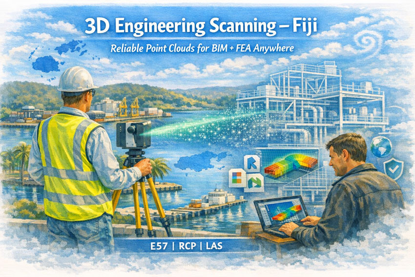
3D Engineering Scanning Fiji – Point Clouds for Design & FEA | Hamilton By Design
Hamilton By Design provides professional 3D laser scanning services across Fiji, delivering high-accuracy point clouds that allow designers, engineers, and asset owners anywhere in the world to work with real, measured data—without stepping foot on site.
Our focus is simple: capture the truth of your asset once, and let every engineering discipline design from the same digital backbone.
Engineering-Grade Data You Can Design From
In Fiji, many industrial, marine, and commercial assets have:
incomplete or outdated drawings
decades of informal modifications
mixed construction standards
corrosion and cyclone damage history
Traditional measurement methods struggle in this environment. Our 3D scanning service produces a survey-accurate digital replica that can be used for:
3D modelling in Revit, Plant3D, Tekla, SolidWorks
structural analysis and FEA studies
clash detection for new equipment
fabrication of steel and pipework
condition assessments and deformation checks
We deliver neutral, open formats so your team—anywhere in Australia, New Zealand, Fiji, or globally—can immediately begin engineering work.
What We Deliver
Core Outputs
Registered point clouds (E57 / RCP / LAS)
Colourised, engineering-accurate datasets
Site coordinate systems or project datum
Mesh models for Navisworks / visualisation
2D plans, elevations, and sections
Optional Engineering Deliverables
Scan-to-BIM models (LOD 200–350)
Steel and pipe geometry extraction
Tie-in coordinates for brownfields projects
Deformation and roundness reports
Clash and constructability reviews
Every dataset is processed in Australia under formal QA procedures so it can be relied upon for detailed design, certification, and FEA modelling.
Designed for Fiji Conditions
Scanning in Fiji requires more than equipment—it requires experience in Pacific environments.
We plan projects around:
tropical heat and humidity
sudden rain events
reflective stainless and bright sunlight
inter-island logistics
remote power and access constraints
cyclone season scheduling
Our workflows are built so field capture is efficient and robust, while processing and modelling are completed by our Australian engineering team.
Industries We Support in Fiji
Ports and wharves – Suva, Lautoka, Levuka
Power generation and utilities
Sugar and food processing plants
Water and wastewater infrastructure
Resorts and commercial buildings
Bridges and civil structures
Post-cyclone assessments
Mining and materials handling
A Digital Backbone for Global Teams
A quality scan is the backbone of every downstream task. If the backbone is wrong, every model, drawing, and FEA result is compromised.
Our aim is to give your project a foundation that:
removes re-measure risk
allows off-site fabrication
supports remote engineering teams
shortens shutdowns
improves safety and constructability
Designers and engineers in any location can open our data and begin work immediately—confident it represents the real world.
Why Choose Hamilton By Design
Engineer-led scanning team
Australian processing and QA
experience in PNG and Pacific brownfields
deliverables tailored to your software
practical understanding of fabrication and FEA requirements
We don’t just capture points—we deliver usable engineering information.
Talk to Us About Your Fiji Project
Whether you need a single building, a wharf, or a full processing plant captured, we can mobilise quickly and provide data your global team can trust.
Hamilton By Design Engineering certainty through 3D scanning.
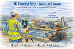
3D Scanning Perth – Scan-to-BIM Services | Hamilton By Design
In an era where digital precision underpins engineering success, the integration of 3D Scanning Perth – Scan-to-BIM Services has emerged as a vital component of contemporary project delivery. The services offered by Hamilton By Design – 3D Scanning Services Perth exemplify this integration, aligning advanced engineering-grade LiDAR capture with structured digital modelling workflows that directly support Building Information Modelling (BIM) deliverables.
At its core, 3D scanning in Perth is positioned not merely as a mechanism for acquiring visual datasets, but as a fundamental measurement process that transitions physical reality into validated digital representations. Engineering-grade terrestrial laser scanning produces high-resolution point clouds with measurable geometry—data that BIM platforms rely on for spatial coordination, clash detection, and as-built accuracy in complex environments such as industrial plants, construction sites, and marine facilities.
A key advantage of this engineered data capture is its capacity to feed directly into Scan-to-BIM workflows. From the registered point clouds, detailed 3D models can be developed that adhere to the precision expectations of BIM deliverables—supporting design verification, stakeholder coordination, and multidisciplinary integration. These deliverables typically include:
Registered high-accuracy point cloud datasets suitable for BIM import
Scan-derived 3D CAD models aligned with BIM spatial and tolerance requirements
As-built BIM models that reflect true-to-site geometry for retrofit and renovation projects
Documentation packages that underpin regulatory compliance and construction sequencing
Such deliverables ensure that project stakeholders work from a common, reliable digital baseline, effectively bridging the gap between field conditions and model-based project execution. This alignment enhances predictability in engineering coordination and reduces rework associated with discrepancies between assumed conditions and actual site geometry—a fundamental premise of BIM methodology.
Furthermore, when 3D scanning is integrated with BIM workflows in Perth, it supports advanced uses such as clash analysis, spatial coordination, and virtual construction planning. These processes provide multidisciplinary teams with confidence that modelled elements reflect real constraints and interfaces before fabrication and on-site assembly.
In summary, the 3D Scanning Perth – Scan-to-BIM Services articulated by Hamilton By Design demonstrates how high-accuracy spatial capture, when embedded within an engineering-centric workflow, can produce BIM deliverables that elevate project outcomes. By anchoring digital models to measured realities and structuring data for downstream use, clients are equipped with robust, actionable information that enhances design quality, coordination, and constructability across complex ventures.
To provide the best experiences, we use technologies like cookies to store and/or access device information. Consenting to these technologies will allow us to process data such as browsing behaviour or unique IDs on this site. Not consenting or withdrawing consent, may adversely affect certain features and functions.
Functional
Always active
The technical storage or access is strictly necessary for the legitimate purpose of enabling the use of a specific service explicitly requested by the subscriber or user, or for the sole purpose of carrying out the transmission of a communication over an electronic communications network.
Preferences
The technical storage or access is necessary for the legitimate purpose of storing preferences that are not requested by the subscriber or user.
Statistics
The technical storage or access that is used exclusively for statistical purposes.The technical storage or access that is used exclusively for anonymous statistical purposes. Without a subpoena, voluntary compliance on the part of your Internet Service Provider, or additional records from a third party, information stored or retrieved for this purpose alone cannot usually be used to identify you.
Marketing
The technical storage or access is required to create user profiles to send advertising, or to track the user on a website or across several websites for similar marketing purposes.