The Real-World Accuracy of 3D LiDAR Scanning With FARO S150 & S350 Scanners

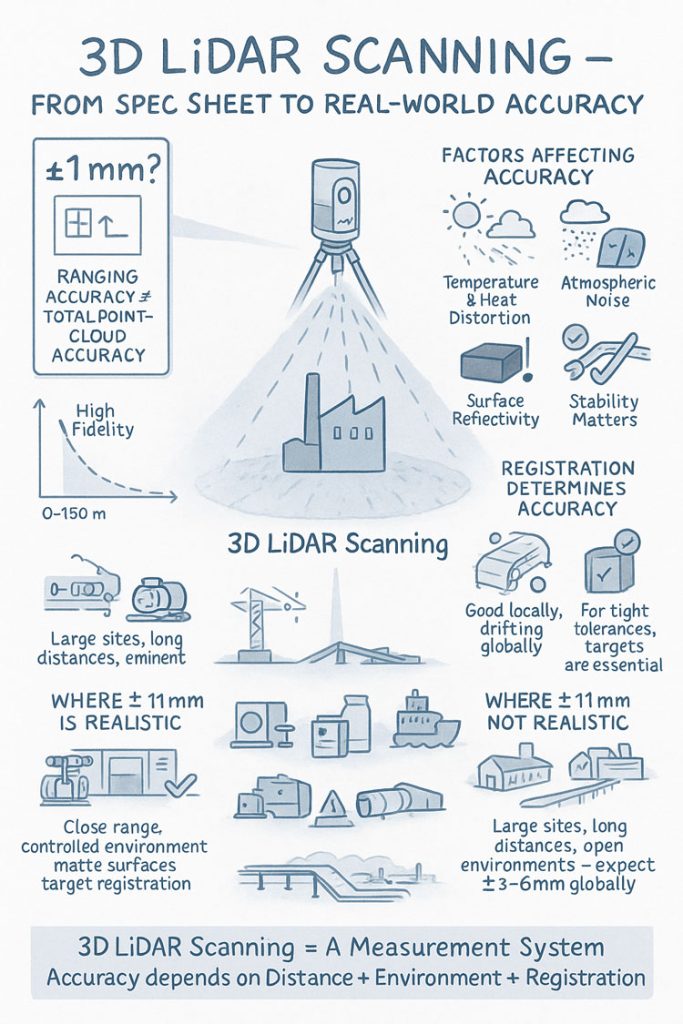
When people first explore 3D LiDAR scanning, one of the most eye-catching numbers in any product brochure is the advertised accuracy. FAROโ€™s Focus S150 and S350 scanners are often promoted as delivering โ€œยฑ1 mm accuracy,โ€ which sounds definitive and easy to rely on for engineering, mining and fabrication work. But anyone who has spent time working with 3D LiDAR scanning in real industrial environments understands that accuracy isnโ€™t a single number โ€” it is a system of interrelated factors.

This article explains what the ยฑ1 mm specification from FARO really means, how accuracy shifts with distance, and what engineers, project managers and clients need to do to achieve dependable results when applying 3D LiDAR scanning on live sites.

3D LiDAR scanning and 3D modelling service button โ€” laser scanner capturing a point cloud for engineering and CAD modelling
Mechanical engineering services

Infographic explaining 3D LiDAR scanning accuracy, showing a scanner capturing a building and highlighting factors that affect accuracy such as temperature, atmospheric noise, surface reflectivity and tripod stability. Includes diagrams comparing realistic versus unrealistic ยฑ1 mm accuracy, the impact of distance, environment and registration quality, and notes that large open sites typically achieve ยฑ3โ€“6 mm global accuracy.

1. What FAROโ€™s โ€œยฑ1 mm Accuracyโ€ Really Means in 3D LiDAR Scanning

The ยฑ1 mm number applies only to the internal distance measurement unit inside the scanner. It reflects how accurately the laser measures a single distance in controlled conditions.

It does not guarantee:

  • ยฑ1 mm for every point in a full plant model
  • ยฑ1 mm for every dimension extracted for engineering
  • ยฑ1 mm global accuracy across large multi-scan datasets

In 3D LiDAR scanning, ranging accuracy is just one ingredient. Real-world accuracy is shaped by distance, reflectivity, scan geometry and how multiple scans are registered together.


2. How Accuracy Changes With Distance in Real Projects

Even though the S150 and S350 list the same ranging accuracy, their 3D LiDAR scanning performance changes as distance increases. This is due to beam divergence, angular error, environment and surface reflectivity.

Typical real-world behaviour:

  • 0โ€“10 m: extremely precise, often sub-millimetre
  • 10โ€“25 m: excellent for engineering work, only slight noise increase
  • 25โ€“50 m: more noticeable noise and increasing angular error
  • 50โ€“100 m: atmospheric distortion and reduced overlap become evident
  • Near maximum range: still useful for mapping conveyors, yards and structures, but not suitable for tight fabrication tolerances

This distance-based behaviour is one of the most important truths to understand about 3D LiDAR scanning in field conditions.


3. Ranging Accuracy vs Positional Accuracy vs Global Accuracy

Anyone planning a project involving 3D LiDAR scanning must distinguish between:

Ranging Accuracy

The ยฑ1 mm value โ€” only the distance measurement.

3D Positional Accuracy

The true X/Y/Z location of a point relative to the scanner.

Global Point Cloud Accuracy

How accurate the entire dataset is after registration.

Global accuracy is the number engineers depend on, and it is normally around ยฑ3โ€“6 mm for large industrial sites โ€” completely normal for terrestrial 3D LiDAR scanning.


4. What Real Field Testing Reveals About FARO S-Series Accuracy

Independent practitioners across mining, infrastructure, CHPPs, plants and structural environments report similar results when validating 3D LiDAR scanning against survey control:

  • ยฑ2โ€“3 mm accuracy in compact plant rooms
  • ยฑ5โ€“10 mm across large facilities
  • Greater drift across long, open, feature-poor areas

These outcomes are not equipment faults โ€” they are the natural result of how 3D LiDAR scanning behaves in open, uncontrolled outdoor environments.


5. Why Registration Matters More Than the Scanner Model

Most real-world error in 3D LiDAR scanning comes from registration, not the laser itself.

Cloud-to-Cloud Registration

Good for dense areas, less reliable for long straight conveyors, open yards or tanks.

Target-Based Registration

Essential for high-precision engineering work.
Allows tie-in to survey control and dramatically improves global accuracy.

If your project needs ยฑ2โ€“3 mm globally, target control is mandatory in all 3D LiDAR scanning workflows.


6. Surface Reflectivity and Environmental Effects

Reflectivity dramatically affects measurement quality during 3D LiDAR scanning:

  • Matte steel and concrete return excellent data
  • Rusted surfaces return good data
  • Dark rubber, black plastics and wet surfaces reduce accuracy
  • Stainless steel and glass behave unpredictably

Environmental factors โ€” wind, heat shimmer, dust, rain โ€” also reduce accuracy. Early morning or late afternoon typically produce better 3D LiDAR scanning results on mining and industrial sites.


7. When ยฑ1 mm Is Actually Achievable

True ยฑ1 mm accuracy in 3D LiDAR scanning is realistic when:

  • Working within 10โ€“15 m
  • Surfaces are matte and reflective
  • Registration uses targets
  • Tripod stability is high
  • Conditions are controlled

This makes it suitable for:

  • Pump rooms
  • Valve skids
  • Structural baseplates
  • Reverse engineering
  • Small mechanical upgrades

But achieving ยฑ1 mm across a full plant, CHPP, or yard is outside the capability of any terrestrial 3D LiDAR scanning workflow.


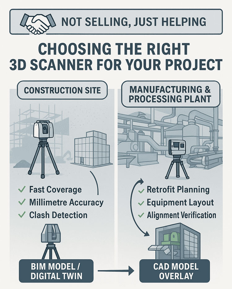
8. S150 vs S350: Which One for Your Accuracy Needs?

S150 โ€“ Engineering-Focused Precision

Ideal for industrial rooms, skids, structural steel and retrofit design work where short-to-mid-range accuracy is essential.

S350 โ€“ Large-Area Coverage

Perfect for conveyors, rail lines, yards, and outdoor infrastructure.
Global accuracy must be survey-controlled for tight tolerances.

Both scanners deliver excellent 3D LiDAR scanning performance, but the S150 is the engineering favourite while the S350 is the large-site specialist.


9. What to Specify in Contracts to Avoid Misunderstandings

Instead of stating:

โ€œScanner accuracy ยฑ1 mm.โ€

Specify:

  • Local accuracy requirement (e.g., ยฑ2 mm at 15 m)
  • Global accuracy requirement (e.g., ยฑ5 mm total dataset)
  • Registration method (mandatory target control)
  • Environmental constraints
  • Verification method (e.g., independent survey checks)

This ensures everyone understands what 3D LiDAR scanning will realistically deliver.


10. When a Terrestrial Scanner Is Not Enough

Do not rely solely on 3D LiDAR scanning for:

  • Machine alignment <1 mm
  • Bearing or gearbox placement
  • Certified dimensional inspection
  • Metrology-level tolerances

In these cases, supplement scanning with:

  • Laser trackers
  • Total stations
  • Metrology arms
  • Hybrid workflows

Conclusion: The Real Truth About 3D LiDAR Scanning Accuracy

FAROโ€™s S150 and S350 are outstanding tools for industrial 3D LiDAR scanning, but the ยฑ1 mm spec does not tell the full story. Real-world accuracy is a combination of:

  • Distance
  • Registration method
  • Surface reflectivity
  • Site conditions
  • Workflow discipline

When used correctly, these scanners consistently deliver high-quality, engineering-grade point clouds suitable for clash detection, retrofit design, fabrication planning and as-built documentation.

3D LiDAR scanning is not just a laser โ€” it is an entire measurement system.
And when the system is applied with care, it produces reliable, repeatable data that reduces rework, improves safety, and strengthens decision-making across mining, construction, fabrication and industrial operations.

Where Is your project

3D Scanning Sydney CBD3D Scanning Brisbane CBD
3D Scanning across Melbourne3D Scanning across Perth
3D Scanning across Adelaide3D Scanning in The Hunter Valley
3D Scanning Mount Isa3D Scanning Emerald
3D Laser Scanning Central Coast3D Scanning in The Pilbara
3d Scanning other Areas of Australia3D Scanning Outside Australia
Hamilton By Design logo displayed on a blue tilted rectangle with a grey gradient background
3D LiDAR scanning and 3D modelling service button โ€” laser scanner capturing a point cloud for engineering and CAD modelling
Mechanical engineering services
Name
Address
You would like to:

3D CAD Modelling | 3D Scanning

3D Experience Platform Login

3D Scanning for Construction

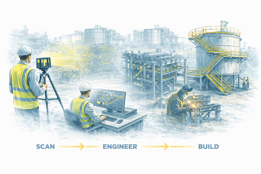
Transforming Projects with 3D Scanning

3D LiDAR Scanning โ€“ Digital Quality Assurance

3D Laser Scanning Across Australia

Image of 3d Scanning for Mechanical Engineers

High-Accuracy LiDAR Scanning for Mining, Engineering, Construction & Industrial Projects Nationwide

Hamilton By Design provides professional 3D laser scanning and LiDAR measurement services across Australia, supporting mining operations, industrial facilities, construction projects and commercial developments with accurate and reliable as-built digital data.

Wherever your project is located โ€” remote mine sites, regional industrial hubs, coastlines, capital cities, or remote processing plants โ€” our team delivers millimetre-accurate scans to eliminate measurement errors and streamline engineering and fabrication workflows.

We help clients achieve a โ€œfirst-time-rightโ€ installation, reduce project risks, and improve planning certainty regardless of location.


“From millimetre-accurate reality capture to fit-for-fabrication drawings โ€” we deliver data you can build from with confidence.โ€ – Anthony Hamilton


3D LiDAR scanning and 3D modelling service button โ€” laser scanner capturing a point cloud for engineering and CAD modelling
Mechanical engineering services

Australia-Wide Locations We Service

We provide 3D scanning support to every state and territory, with rapid mobilisation to regional and remote areas.

Queensland

  • Townsville & FNQ โ€“ port facilities, sugar mills, industrial plants
  • Brisbane / SEQ โ€“ commercial, industrial, construction and mechanical plant
  • Mount Isa โ€“ hard-rock mining, processing plants, conveyors, structures
  • Emerald & Bowen Basin โ€“ CHPP wash plants, coal handling, shutdown support

Western Australia

  • Perth โ€“ industrial facilities, water infrastructure, commercial sites
  • The Pilbara โ€“ major iron ore operations, conveyors, crushers, port systems
  • Kalgoorlie โ€“ gold processing, structural audits, mill upgrades

New South Wales

  • Sydney โ€“ construction scanning, commercial buildings, industrial assets
  • Newcastle & Hunter Valley โ€“ coal handling, steel manufacturing, engineering plants
  • Central Coast โ€“ residential, commercial and industrial scanning

Victoria

  • Melbourne โ€“ construction, commercial fit-outs and industrial facilities
  • Regional VIC โ€“ manufacturing and mechanical plant scanning

South Australia

  • Adelaide โ€“ industrial, water, manufacturing and port infrastructure
  • Regional SA โ€“ mining, agriculture, structural and mechanical assets

Northern Territory

  • Darwin โ€“ defence, utilities, ports, heavy industry
  • Remote mining โ€“ shutdown support, mechanical/structural scanning

Tasmania

  • Hydro assets, manufacturing plants, industrial facilities

Australian Capital Territory

  • Government facilities, commercial properties, construction scanning

Wherever your site is located, Hamilton By Design can scan it.


What We Provide Australia-Wide

Hamilton By Design delivers comprehensive digital capture services for all industries, including:

As-Built 3D Laser Scanning

Capture the true geometry of:

  • Processing plants
  • Conveyors, transfer towers and chutes
  • Structural frames, walkways and platforms
  • Mechanical rooms, pump stations and pipe networks
  • Commercial buildings and construction sites
  • Industrial equipment and machinery

Scan-to-CAD Modelling

We convert point cloud data into:

  • SolidWorks 3D solid models
  • Fabrication-ready drawings
  • Digital twins
  • BIM-compatible geometry
  • Navisworks coordination models

Shutdown, Upgrade & Maintenance Support

Our scanning improves:

  • Fitment accuracy for replacement parts
  • Planning for structural or mechanical upgrades
  • Safety by reducing time at heights or near live plant
  • Shutdown duration and reliability
  • Communication between engineers, fabricators and installers

Digital QA & Verification

Before new components leave the workshop, we can:

  • Scan the fabricated component
  • Compare it against the model
  • Verify dimensional accuracy
  • Confirm perfect onsite fit

Ideal for mining and industrial shutdowns.


Industries We Support Nationwide

  • Mining & Resources
  • Coal Handling & CHPP
  • Iron Ore, Gold & Hard-Rock Operations
  • Ports & Bulk Material Handling
  • Water, Utilities & Treatment Plants
  • Manufacturing & Industrial Facilities
  • Construction & Commercial Developments
  • Rail, Transport & Infrastructure
  • Fabrication Workshops & OEMs

If it needs to be upgraded, modelled, measured, replaced or verified โ€” we can scan it.


Benefits of 3D Scanning Anywhere in Australia

Millimetre-accurate as-built data

No more guesswork, no more rework.

Reduced shutdown risk

Perfect fitment the first time.

Improved safety

Minimal working at heights or near live equipment.

Lower project costs

Fewer site visits, fewer fabrication errors.

Better communication

Point clouds, 3D models and digital twins all stakeholders can understand.

Faster project delivery

Clean, accurate data accelerates engineering and fabrication.


Why Choose Hamilton By Design for Australia-Wide Scanning?

  • Experience across mining, industrial, structural and mechanical environments
  • Fast mobilisation to remote or regional locations
  • FARO high-precision LiDAR scanning
  • Advanced SolidWorks modelling workflows
  • Practical engineering knowledge behind every scan
  • Fabrication-ready deliverables for contractors and workshops
  • Reliable support before, during and after shutdowns

We bring digital accuracy to the places where it matters most.


Hamilton By Design logo displayed on a blue tilted rectangle with a grey gradient background
3D LiDAR scanning and 3D modelling service button โ€” laser scanner capturing a point cloud for engineering and CAD modelling
Mechanical engineering services

Book 3D Laser Scanning Anywhere in Australia – Talk to Us

Whether youโ€™re planning a shutdown, designing an upgrade, documenting an existing facility or verifying new fabrications, Hamilton By Design can support your project with fast, precise and professional 3D scanning.

Our clients

Contact us today to book a scan or request a project review.

Name
Address
You would like to:

3D Point Clouds Are a Game-Changer for Your Projects

Your Experts in 3D Laser Scanning & Mechanical Design

3D CAD Modelling | 3D Scanning3D Experience Platform Login

Hamilton By Design

Choosing the Right 3D Scanner for Construction, Manufacturing, and Mining Projects

At Hamilton By Design, we know that 3D scanning has become an essential tool for modern engineering โ€” from capturing as-built conditions on construction sites to modeling complex processing plants and validating manufacturing layouts. But not all scanners are created equal, and selecting the right technology is crucial to getting reliable data and avoiding costly surprises later in the project.

3D Scanning for Construction Sites

For construction and infrastructure projects, coverage and speed are the top priorities. Terrestrial Laser Scanning (TLS) and LiDAR systems like the FARO Focus S70 are ideal for quickly capturing entire job sites with millimetre-level accuracy. These scanners allow engineers and project managers to:

  • Verify as-built conditions against design models
  • Detect clashes early in the process
  • Support accurate quantity take-offs and progress documentation

TLS works well in tough environments โ€” dust, sunlight, and complex geometry โ€” making it a perfect fit for active building sites.

3D Scanning for Manufacturing & Processing Plants

When it comes to manufacturing facilities and mining processing plants, accuracy and detail matter even more. Scans are often used for:

  • Retrofit planning and clash detection in tight plant rooms
  • Structural steel and conveyor alignment checks
  • Equipment layout for expansion projects

Here, combining TLS with feature-based CAD modeling allows us to deliver data that is usable for engineering design, ensuring that new equipment fits exactly as intended.

Infographic titled โ€˜Choosing the Right 3D Scanner for Your Projectโ€™ with the tagline โ€˜Not Selling, Just Helping.โ€™ The left side shows a construction site with a tripod-mounted 3D scanner and benefits listed: fast coverage, millimetre accuracy, and clash detection, leading to BIM model or digital twin outputs. The right side shows a manufacturing and processing plant with a scanner and benefits: retrofit planning, equipment layout, and alignment verification, leading to CAD model overlay results

Weโ€™re Here to Help

Hamilton By Design doesnโ€™t sell scanners โ€” we focus on providing unbiased, engineering-driven advice. If youโ€™re unsure which scanning approach is right for your project, weโ€™re happy to share our experience and guide you toward the best solution.

Feel free to get in touch to discuss your project needs โ€” whether itโ€™s a construction site, manufacturing facility, or processing plant, we can help you turn accurate scan data into actionable engineering insights.

3D Scanning for Construction Sites |  3D Scanning for Manufacturing | 3D Scanning for Processing Plants

Mechanical Engineering | Structural Engineering

Mechanical Drafting | Structural Drafting

3D CAD Modelling | 3D Scanning

Finite Element Analysis (FEA) engineering simulation button
Mechanical engineering services

3D Scanning

How 3D Laser Scanning is Redefining Reality for Design, Construction & Heritage

Imagine standing before a centuries-old cathedral, where every carved arch, every stained-glass pane, every weathered stone holds centuries of stories. Capturing its true form and condition with tape measure and camera? Tedious and prone to errors. But with 3D laser scanning, you can digitally freeze every detailโ€”down to the imperfectionsโ€”turning reality into an exact, manipulable model.

In an age where precision, speed, and data-driven decisions are non-negotiable, 3D laser scanning is no longer โ€œnice to haveโ€โ€”itโ€™s essential. Letโ€™s explore what it is, why itโ€™s transformative, where itโ€™s being used most powerfully, and how you can harness its potential.

What Is 3D Laser Scanning?

At its core, 3D laser scanning sometimes called terrestrial laser scanning, (TLS) is the emission of laser pulses toward surfaces, recording the time it takes for those pulses to bounce back. From that comes a dense โ€œpoint cloudโ€ โ€” billions of precise data points mapping shape, texture, orientation, and distance.

These point clouds become high-fidelity models, maps, meshes, or BIM ready files. Whether youโ€™re scanning building exteriors, interiors, or industrial components, the result is more than just imageryโ€”itโ€™s measurable, analyzable geometry.

How It Works โ€” The Process

  1. Preparation & Planning

    Define what you need: the level of detail (LOD), resolution, range, and whether external conditions (light, weather) will interfere.

  2. Data Capture

    Position the scanner at multiple stations to cover all surfaces. Use targets or reference markers for alignment and capture with overlapping scans.

  3. Processing & Registration

    Merge scans to align them properly, clean noise, filter out irrelevant data (like people, moving objects), calibrate.

  4. Post-processing & Deliverables

    Convert point clouds into usable outputsโ€”floorplans, sections, elevations, 3D meshes, BIM models, virtual walkthroughs. Run analyses (clash detection, deformation etc.).

  5. Integration & Use

    Use the data in design, restoration, facility management, or documentation. The quality of integration (into BIM, GIS, CAD) is key to unlocking value.

ย 

Key Benefits

Benefit What It Means in Practice Real-World Impact
Extreme Precision Sub-millimetre to millimetre accuracy depending on the scanner and conditions. Less rework. Better fit for retrofit, renovation, or mechanical systems in tight tolerances.
Speed + Efficiency Collect large amounts of spatial data in far less time than traditional measurement. Faster project turnaround. Reduced site time costs.
Non-Contact / Low Disruption Good for fragile structures, hazardous or difficult-to-access places. Preserves integrity of heritage buildings; safer for workers.
Comprehensive Documentation Full visual & geometric context. Informs future maintenance. Acts as an archival record.
Better Decision Making & Conflict Detection Early clash detection; scenario simulation; what-if modelling. Avoids costly mistakes; helps build consensus among stakeholders.
Enhanced Visualisation & Communication Stakeholders can see exactly what exists vs. whatโ€™s being proposed. Improves client buy-in, regulatory approvals, fundraising.

ย 

Applications: Where It Shines

  • Architecture & Renovation: As-built models, restoration of heritage sites.

  • Infrastructure & Civil Engineering: Bridges, tunnels, rail track alignments.

  • Industrial & Manufacturing: Machine part audits, reverse-engineering, plant layout.

  • Heritage & Preservation: Documenting fragile monuments, archaeological sites.

  • Facility Management: Digital twins, maintenance, asset tracking.

  • Environment & Surveying: Terrain mapping, forestry, flood risk mapping (especially when combined with aerial systems or mobile scanning).

Challenges & Best Practices

Nothing is perfect. To get the most out of 3D laser scanning, anticipate and mitigate:

  • Environmental factors: Light, dust, rain, reflective surfaces can introduce noise.

  • Data overload: Massive point clouds are large; need strong hardware & efficient workflows.

  • Alignment & registration errors: Overlaps, control points, and calibration are vital.

  • Skill & Planning: Good operators + good planning = much better outcomes.

Key best practices:

  • Use reference targets for precise registration.

  • Capture overlap of 30-50% between scan positions.

  • Break project into manageable segments.

  • Clean noise early.

  • Think ahead about deliverables and how clients will use the data (design, BIM, VR etc.).

Case Studies & Stories

  • Heritage in Danger: A cathedral in Europe threatened by pollution and structural decay was laser scanned. The point cloud revealed minute deformations, enabling an accurate restoration planโ€”saving costs and preserving history.

  • Infrastructure Efficiency: A civil engineering firm reduced design clashes by 80% on a complex highway project by integrating scans with their BIM workflow.

  • Industrial Switch-Over: Manufacturing plant layout was reconfigured using scan data; downtime reduced because the virtual model matched reality better than the old blueprints.

Software, Tools & Ecosystem

While scanners are vital, the software ecosystem is what unlocks value. Tools that turn raw data into actionable insights include:

  • Reality capture tools (processing point clouds).

  • BIM / CAD integration (e.g. Revit, AutoCAD).

  • Visualization tools (VR, AR, walkthrough).

  • Data sharing & collaboration platforms.

  • Cloud storage / processing if large point clouds.

SaaS/cloud-based workflows are increasingly important to share among remote teams, facilitate stakeholder review, and ensure data is accessible beyond just technical users.

Why It Matters Now

  • Global pressures (heritage, sustainability, faster build cycles, remote work) are raising the bar.

  • Clients expect transparency, accuracy, minimized risk.

  • Regulatory compliance and โ€œas-builtโ€ requirements are stricter.

  • Digital twins & smart infrastructure demand high fidelity data.

3D laser scanning acts as a bridge: between physical world and digital twin; between heritage past and future; between design promise and build reality. Ifย you have a survey scan and want to make sense of point cloud data, contact Hamilton By Design

ย 
ย 
ย 
ย 

Our clients:

Name
Would you like us to arrange a phone consultation for you?
Address
Finite Element Analysis (FEA) engineering simulation button
Mechanical engineering services

Hamilton by Design: Your Experts in 3D Laser Scanning & Mechanical Design

Engineer-led 3D laser scanning of an industrial plant transitioning into mechanical engineering design and steel fabrication.

When it comes to precision engineering, structural drafting, and mechanical design services, Hamilton by Design leads the way. We provide advanced 3D laser scanning solutions across Perth, Sydney, Brisbane, Melbourne, and the Hunter Valley โ€” giving clients accurate data for smarter decisions and efficient project delivery.

Hamilton by Design services diagram showing four key areas: 3D Laser Scanning, Mechanical Design and Engineering, Structural Drafting and Design, and Industries Served. The chart lists services such as 3D point cloud scanning, as-built documentation, reverse engineering, mechanical product development, conveyor drive systems for mining, factory design consulting, FEA, structural steel detailing, and design for construction, manufacturing and industrial sectors. Industries served include construction and infrastructure, and residential and renovations. A footer reads โ€˜3D Laser Scanning and Mechanical Design Australia
3D LiDAR scanning and 3D modelling service button โ€” laser scanner capturing a point cloud for engineering and CAD modelling
Mechanical engineering services

3D Laser Scanning Across Australia

Our 3D laser scanning services capture exact measurements of your site, plant, or equipment to create detailed 3D point clouds and as-built documentation. This reduces rework, saves time, and improves project planning.

We offer:

  • 3D Laser Scanning Perth & Fremantle โ€“ Industrial plant surveys, mining site scanning, and reverse engineering.
  • 3D Laser Scanning Sydney & Melbourne โ€“ Building surveys, renovation planning, and structural inspections.
  • 3D Laser Scanning Brisbane & Hunter Valley โ€“ Factory layouts, conveyor drive design, and structural scanning.
  • 3D Laser Scanning for Engineering & Mining โ€“ Point cloud scanning, clash detection, and 3D modelling.

Our team uses the latest 3D scanning and LiDAR technology to produce millimetre-accurate results that engineers, architects, and builders can trust.

Structural Drafting & Design Services

Hamilton by Design provides structural drafting services across Australia, including:

  • Structural Design and Drafting โ€“ For residential, commercial, and industrial projects.
  • Steel Detailing & Shop Drawings โ€“ Produced to Australian drafting standards.
  • Structural Scanning Services Brisbane & Sydney โ€“ Helping engineers assess existing structures for upgrades or repairs.

Our experienced structural design engineers work closely with builders, architects, and civil engineers in Hamilton and beyond to deliver reliable, build-ready plans.

Engineer using 3D LiDAR scanning to capture an industrial facility, followed by CAD modelling and fabrication-ready steelwork.

See Structural Engineering for more info

Mechanical Design & Engineering Solutions

We are a full-service mechanical design consultancy offering:

  • Mechanical Product Design & Development
  • Factory & Plant Layout Design
  • Conveyor Belt Drive Systems & Mining Equipment Design
  • Finite Element Analysis (FEA) and performance validation
  • Reverse Engineering Services Perth for spare parts and retrofits

Our team of mechanical engineers, drafters, and CAD designers ensures every project is efficient, safe, and cost-effective.

see Mechanical Engineering for more info

Industries We Serve

Hamilton by Design supports clients across:

  • Mining & Resources โ€“ Coal conveyors, feed thickeners, and vibrating equipment in Kalgoorlie and Mount Isa.
  • Construction & Infrastructure โ€“ As-built scanning and 3D modelling for building projects.
  • Manufacturing โ€“ Factory optimization and equipment design.
  • Residential Projects โ€“ Drafting services for home renovations and new builds in Hamilton and surrounding areas.

Why Partner with Hamilton by Design?

Choosing Hamilton by Design means working with mechanical design experts and structural drafters who are committed to accuracy, speed, and innovation.

Infographic showing 3D laser scanning capturing industrial equipment to identify challenges such as vibration, movement, and fluid leaks, feeding into a 3D model that improves planning, reduces rework, and supports safer maintenance

Australia-Wide Coverage โ€“ Perth, Sydney, Melbourne, Brisbane, Hunter Valley
Cutting-Edge Technology โ€“ Laser scanning, CAD modelling, and 3D visualization
Expert Team โ€“ Experienced mechanical engineers and design consultants
Cost-Effective Solutions โ€“ Saving time, reducing errors, and minimizing rework


Get Started Today

Ready to transform your next project with 3D laser scanning, structural drafting, or mechanical design services?

Contact Hamilton by Design for a consultation and see how our team can deliver precise, efficient, and innovative solutions for your business.


Hamilton By Design logo displayed on a blue tilted rectangle with a grey gradient background

Name
Would you like us to arrange a phone consultation for you?
Address

Hamilton By Design โ€“ Blog

Consulting Engineers

About Us โ€“ Hamilton By Design

Contact us

Finite Element Analysis (FEA) engineering simulation button
Mechanical engineering services

Are You Getting the Full Value from Your Point Cloud Data?

3D Scanning

The world of manufacturing and fabrication is moving faster than ever. Point cloud scanning and 3D modeling have made it easier to capture reality with incredible accuracy โ€” but simply collecting data isnโ€™t enough.

Without the right expertise, point clouds often sit unused, underutilized, or worse โ€” lead to costly mistakes when converted into incomplete or inaccurate drawings.

3D Scanning

Thatโ€™s why mechanical engineering consultants are becoming essential partners for forward-thinking businesses. They donโ€™t just process point clouds โ€” they turn them into:

  • High-precision 3D models that match real-world conditions

  • Fabrication-ready drawings that reduce errors and rework

  • Actionable insights that save time, money, and frustration

This is no longer just about technology โ€” itโ€™s about strategy and execution.

Read our full article to discover why now is the perfect time to engage consultants who can unlock the power of your point cloud data:


Itโ€™s Time to Level Up: Why Mechanical Engineering Consultants Are Key to Unlocking the Power of Point Cloud to 3D Modeling

ย 
3D LiDAR scanning and 3D modelling service button โ€” laser scanner capturing a point cloud for engineering and CAD modelling
Mechanical engineering services

Hamilton By Design logo displayed on a blue tilted rectangle with a grey gradient background

Our clients:

Name
Would you like us to arrange a phone consultation for you?
Address
3D LiDAR scanning and 3D modelling service button โ€” laser scanner capturing a point cloud for engineering and CAD modelling
Mechanical engineering services
Finite Element Analysis (FEA) engineering simulation button
Mechanical engineering services