

Not All Point Clouds Are Created Equal
3D laser scanning is now widely used across construction, mining, and industrial projects.
But there’s a major issue we see repeatedly:
The scan is completed — but it’s not usable for engineering.
At first glance, a point cloud can look impressive. Millions of points, full colour, seemingly detailed.
But when it comes time to actually use that data for design…
👉 The gaps start to show.
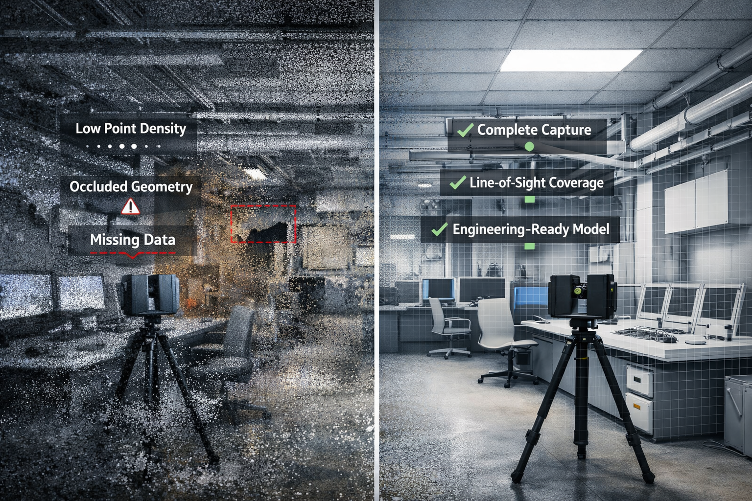
⚠️ The Problem: Low-Quality Scanning
Many scans are undertaken:
- Without understanding how the data will be used
- Using lower-grade equipment
- With insufficient scan positions
- Without capturing critical working areas
The result:
- Missing geometry
- Low point density
- Occluded or hidden areas
- Incomplete or distorted surfaces
In one recent project, we identified areas where:
- The geometry was not fully captured
- Point density was low or non-existent
- Line-of-sight constraints prevented full coverage
🔍 Why This Matters
A point cloud is not the final deliverable — it is the foundation.
And if that foundation is wrong:
- CAD models become inaccurate
- Engineering decisions are based on assumptions
- Design risks increase
- Rework becomes likely
You can’t build a reliable design on incomplete data.
💡 The Difference: Engineer-Led Scanning
At Hamilton By Design, scanning is not just data capture.
It is:
👉 An engineering process
We approach every scan with the end use in mind.
🏗️ What Engineer-Led Scanning Looks Like
1. Understanding the End Goal
Before scanning begins, we define:
- What the model will be used for
- Required level of detail
- Critical areas that must be captured
2. Planning Scan Positions
We ensure:
- Full coverage of all key geometry
- Minimal occlusions
- Adequate point density for modelling
3. Capturing Complete Geometry
We focus on:
- Line-of-sight access between scanner and surfaces
- Eliminating blind spots
- Capturing real working areas — not just open space
4. Validating the Data
Before modelling begins, we:
- Review scan coverage
- Identify missing or weak areas
- Confirm the dataset is fit for purpose
⚙️ Why This Matters for Downstream Design
Engineering workflows rely on accurate geometry.
For example, in lighting design using AGi32:
- Walls influence light reflection
- Equipment creates shadowing
- Layout impacts visibility
If these elements are missing or incorrect:
👉 The design outcome will be wrong.
🔄 The True Cost of Poor Scanning
Low-quality scanning often leads to:
- Time lost rebuilding missing geometry
- Engineering assumptions instead of real data
- Incorrect design decisions
- Additional site visits
- Project delays and rework
What appears cheaper upfront often becomes significantly more expensive later.
✅ The Value of Getting It Right the First Time
Engineer-led scanning delivers:
- Accurate, complete datasets
- Faster modelling workflows
- Reliable design outcomes
- Reduced project risk
It ensures the data is not just captured — but usable.
🚀 Where Hamilton By Design Adds Value
We bridge the gap between:
👉 Reality (scan data)
👉 Engineering (CAD models)
👉 Design outcomes
Our capability includes:
- Engineering-grade 3D laser scanning
- Point cloud to CAD modelling
- Scan-to-design workflows
- Support for industrial, infrastructure, and plant projects


📌 Final Thought
3D scanning is only valuable if it supports accurate engineering decisions.
A scan is not just data — it’s the foundation of your entire project.
And that foundation needs to be right.

📞 Need Reliable Scan Data?
If you’re:
- Planning a project
- Working with poor-quality point clouds
- Or want to avoid costly rework
We can help ensure your data — and your design — are right from the start.
👉 https://www.hamiltonbydesign.com.au
👉 Get in touch to discuss your project


