Industrial 3D Scanning in Perth and Western Australia

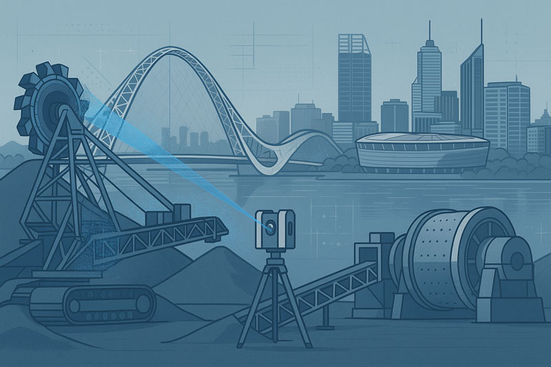
Stylised illustration of a 3D laser scanner capturing point-cloud data from mining equipment, including a reclaimer and a SAG mill, set against the Perth skyline. Visible landmarks include Matagarup Bridge, Optus Stadium, and city skyscrapers across the Swan River. The image represents industrial 3D scanning and engineering services in Western Australia

Engineering-Grade Terrestrial LiDAR Scanning Services Across Perth and Western Australia
Blue 3D LiDAR scanner icon on a tripod with scanning waves

Hamilton By Design provides 3D LiDAR scanning for industrial facilities in Perth and across Western Australia. We capture existing plant, equipment, pipework and structures, then turn the scan data into registered point clouds, CAD models and drawings for plant upgrades, shutdowns and equipment replacement.

Tell us the site location, the asset or area to be scanned, and whether you need scan data only or engineering drawings. We will scope the site visit, deliverables and mobilisation in your quotation.


LiDAR scanning has become one of the most effective methods for capturing accurate three-dimensional information from existing industrial facilities, infrastructure assets and commercial buildings. By using terrestrial laser scanning technology, millions of survey-grade measurement points can be collected in a matter of hours, creating a highly detailed digital representation of real-world environments.

Hamilton By Design provides engineering-led LiDAR scanning services throughout Perth and Western Australia, supporting mining operations, mineral processing facilities, manufacturing plants, infrastructure projects and complex industrial environments.

Unlike traditional measurement methods that rely on individual dimensions and manual site sketches, terrestrial LiDAR captures complete environments, enabling project teams to work from measured reality rather than assumptions.

The resulting point cloud data provides an accurate digital record of existing conditions and can be used to support asset management, engineering studies, refurbishment projects, shutdown planning, construction verification and digital transformation initiatives.

What Is LiDAR Scanning?

LiDAR (Light Detection and Ranging) is a measurement technology that uses laser pulses to determine the position of objects and surfaces within an environment. By recording the time taken for each laser pulse to travel to a surface and return to the scanner, millions of highly accurate measurements can be captured and converted into a three-dimensional digital representation of the real world.

Modern terrestrial LiDAR scanners can collect hundreds of thousands of measurements per second, enabling large industrial facilities, processing plants, infrastructure assets and commercial buildings to be documented quickly and accurately.

The resulting dataset is commonly referred to as a point cloud. Each point represents a measured location in three-dimensional space and collectively forms a detailed digital record of the scanned environment.

For industrial and engineering projects, LiDAR scanning provides a practical alternative to traditional tape measures, manual surveys and incomplete legacy drawings. Rather than measuring individual dimensions, entire facilities can be captured in a single coordinated dataset, allowing project teams to review, analyse and measure existing conditions long after the site visit has been completed.

LiDAR scanning is now widely used throughout mining, mineral processing, manufacturing, power generation, water treatment, transport infrastructure and commercial construction projects where accurate existing-condition information is essential for successful project delivery.


How Terrestrial LiDAR Scanning Works

Terrestrial LiDAR scanners are positioned at multiple locations throughout a site to capture measurements from different viewpoints. During each scan, the instrument emits laser pulses that reflect from surrounding surfaces and return to the scanner. These measurements are combined with angular position information to determine the precise three-dimensional location of each point.

Because industrial facilities often contain equipment, structures, pipework and other objects that can obstruct the line of sight, multiple scan positions are typically required to capture the complete environment. The individual scans are then aligned and registered together to create a unified point cloud representing the entire site.

Modern LiDAR systems can capture millions of measurements within a relatively short period, allowing large areas to be documented efficiently while maintaining a high level of detail. Colour imagery can also be captured during the scanning process, providing additional visual context for project teams reviewing the data.

Once registration and quality checks have been completed, the resulting point cloud can be viewed, measured and analysed using specialised software platforms. Engineers, designers, asset owners and project managers can then access accurate existing-condition information without requiring repeated site visits.

This process creates a digital record of the facility at the time of capture, providing valuable information for refurbishment projects, shutdown planning, asset management, engineering studies, construction verification and future modifications.

Benefits of LiDAR Scanning for Industrial Facilities

Industrial facilities are constantly evolving. Equipment is upgraded, pipework is rerouted, structures are modified and assets are replaced over time. In many cases, existing drawings no longer accurately represent current site conditions, creating challenges for maintenance teams, engineers, contractors and asset owners.

LiDAR scanning provides a reliable method of capturing accurate existing-condition information before project work begins. By collecting millions of measurement points across an entire facility, project teams gain access to a detailed digital representation of the site that can be reviewed and measured long after fieldwork has been completed.

One of the primary benefits of LiDAR scanning is the reduction in repeat site visits. Rather than returning to site to confirm dimensions or investigate potential clashes, teams can often access the required information directly from the registered point cloud.

LiDAR scanning can also improve project planning and coordination. Designers, engineers and stakeholders can review existing conditions using a common dataset, helping to identify spatial constraints, access requirements and potential conflicts before fabrication or construction activities commence.

For operational facilities, data capture can often be completed while minimising disruption to production activities. This allows project teams to obtain accurate site information without the extended downtime that may be associated with traditional measurement methods.

Additional benefits of LiDAR scanning include:

  • Rapid capture of complex environments
  • Improved visibility of existing conditions
  • Reduced reliance on legacy drawings
  • Enhanced project planning and coordination
  • Better understanding of spatial relationships
  • Reduced risk of measurement errors
  • Improved documentation of assets and infrastructure
  • Support for digital engineering and asset management initiatives

As industrial facilities continue to adopt digital engineering workflows, LiDAR scanning is increasingly becoming a foundational tool for capturing reliable information that supports decision-making throughout the asset lifecycle.

LiDAR Scanning for Mining and Resources Projects

The mining and resources sector operates some of the most complex industrial facilities in Australia. Processing plants, conveyors, crushers, transfer stations, stockpile systems, workshops, tank farms, smelters and materials handling infrastructure often undergo continuous modification throughout their operational life.

Accurate existing-condition information is essential when planning upgrades, shutdowns, equipment replacements and brownfield expansion projects. Unfortunately, many sites rely on legacy drawings that may no longer accurately reflect the current configuration of the facility.

Terrestrial LiDAR scanning provides a practical solution by capturing the actual physical environment as it exists on site. Millions of measurement points can be collected across plant areas, creating a detailed digital record that supports engineering, maintenance and asset management activities.

Within mining and resource operations, LiDAR scanning is commonly used to document:

  • Processing plants and beneficiation facilities
  • Conveyors and materials handling systems
  • Crushers, screens and transfer stations
  • Smelters and refining operations
  • Structural steel and access platforms
  • Pipe racks and process services
  • Tank farms and storage facilities
  • Workshops and maintenance infrastructure
  • Shutdown and turnaround project areas
  • Brownfield expansion locations

The resulting point cloud provides project teams with a reliable source of information for planning and decision-making. Existing conditions can be reviewed before personnel return to site, helping improve project preparation and reducing uncertainty during design and construction activities.

LiDAR scanning is particularly valuable where access is difficult, production schedules are constrained or facilities have undergone numerous modifications over time. By capturing measured reality, project teams can work from current site information rather than assumptions or outdated documentation.

Across Western Australia, LiDAR scanning is increasingly supporting mining, mineral processing, oil and gas, bulk materials handling and heavy industrial facilities as organisations continue to adopt digital engineering and asset management practices.

Point Cloud Registration and Quality Assurance

The quality of a LiDAR scanning project is determined not only by the data collected in the field but also by the processes used to align, verify and validate that information after capture. Individual scans must be accurately combined to create a single coordinated dataset that represents the facility as a whole.

This process is known as point cloud registration. During registration, overlapping scan positions are aligned using common reference points and geometric features captured throughout the scanning process. The objective is to ensure that all scans occupy the correct position within the three-dimensional environment and accurately represent the physical site conditions.

For industrial facilities, registration is particularly important because projects often involve multiple scan locations, complex structures and extensive plant areas. Without proper registration, measurement accuracy can be reduced and inconsistencies may be introduced into the final dataset.

Quality assurance procedures are typically undertaken throughout both fieldwork and data processing activities. These checks may include:

  • Verification of scan coverage
  • Review of registration quality reports
  • Validation of overlapping scan positions
  • Identification of missing or obscured areas
  • Assessment of point cloud consistency
  • Confirmation of coordinate systems where applicable
  • Review of deliverable requirements

By applying structured registration and quality assurance processes, project teams can have greater confidence that the resulting point cloud accurately reflects the conditions present at the time of capture.

A well-registered point cloud provides a reliable foundation for future project activities including asset documentation, engineering studies, refurbishment planning, digital engineering workflows and construction verification. It also enables stakeholders to extract measurements, review spatial relationships and investigate site conditions without relying solely on field observations.

As industrial facilities become increasingly reliant on digital information, point cloud registration and quality assurance remain essential components of delivering accurate, dependable and usable LiDAR scanning data.

Engineering-Grade Accuracy and Data Validation

Accuracy is one of the primary reasons organisations choose terrestrial LiDAR scanning for industrial, infrastructure and asset management projects. The ability to capture millions of measured points across an environment provides project teams with a detailed representation of existing site conditions that can support planning, design and decision-making activities.

However, achieving reliable results requires more than simply operating a scanner. The quality of the final point cloud is influenced by factors including scan planning, equipment selection, site conditions, registration workflows and quality assurance procedures.

Engineering-grade LiDAR scanning focuses on capturing data that is suitable for practical project applications. This begins with identifying the objectives of the survey and understanding the level of detail required. Different projects may require different scanning resolutions, coverage areas and validation procedures depending on how the data will ultimately be used.

Several factors can influence data quality, including:

  • Distance between the scanner and the target
  • Surface characteristics and material reflectivity
  • Environmental conditions during capture
  • Line-of-sight restrictions
  • Plant congestion and equipment density
  • Scan position planning
  • Registration quality between scans

Industrial facilities can present additional challenges due to elevated structures, confined spaces, complex pipework arrangements and restricted access areas. Effective scan planning helps minimise these challenges and improves overall dataset quality.

Data validation is an important part of the workflow and helps confirm that the point cloud accurately represents the physical environment. Validation activities may include reviewing registration reports, checking critical dimensions, assessing coverage and confirming that project-specific requirements have been achieved.

It is also important to recognise that no measurement technology is entirely free from limitations. Areas hidden from the scanner’s line of sight, highly reflective surfaces and inaccessible locations may require additional scan positions or supplementary verification methods. Understanding these limitations helps ensure realistic project expectations and reliable outcomes.

When supported by appropriate planning, registration and quality assurance procedures, terrestrial LiDAR scanning provides a dependable source of existing-condition information for industrial facilities, mining operations, infrastructure assets and complex engineering environments.

As digital engineering and asset management practices continue to evolve, accurate and validated point cloud data is becoming an increasingly important resource for organisations seeking to make informed decisions based on measured reality rather than assumptions.

Point Cloud Deliverables and Data Formats

One of the advantages of terrestrial LiDAR scanning is the flexibility of the data that can be generated and shared with project stakeholders. The information collected during scanning can be processed into a range of deliverables depending on project objectives, software requirements and intended workflows.

The primary output of a LiDAR scanning project is typically a registered point cloud. This dataset contains millions of measured points representing the surfaces and geometry of the scanned environment. Point clouds can be viewed, measured and analysed using a variety of industry-standard software platforms.

Depending on project requirements, point cloud data may be delivered in formats such as:

  • E57
  • RCP
  • RCS
  • LAS
  • XYZ
  • PTS
  • PTX

These formats allow owners, engineers, consultants and contractors to access and utilise the captured information within their preferred software environment.

Point cloud data can support a wide range of activities including:

  • Existing-condition documentation
  • Asset management
  • Engineering studies
  • Refurbishment planning
  • Construction verification
  • Shutdown planning
  • Clash detection
  • Digital engineering workflows
  • Digital twin development

In addition to point cloud deliverables, project teams may use the captured data to generate drawings, models and visualisations that assist with planning and communication. The level of detail required will depend on the intended use of the information and the objectives of the project.

An important advantage of maintaining point cloud datasets is that measurements can often be extracted after the site visit has been completed. This allows stakeholders to review dimensions, investigate site conditions and obtain additional information without necessarily returning to the field.

As organisations continue to adopt digital engineering and asset management practices, LiDAR-generated datasets are becoming an increasingly valuable source of information for understanding, documenting and managing existing assets throughout their lifecycle.

By providing accurate and accessible digital representations of real-world environments, LiDAR scanning helps establish a foundation for informed decision-making across planning, design, operations and maintenance activities.
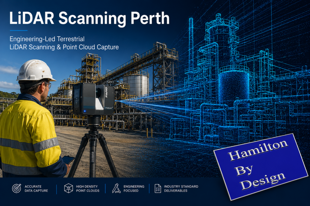
LiDAR Scanning Perth promotional banner showing a terrestrial laser scanner capturing an industrial processing facility, with a digital point cloud overlay illustrating engineering-led reality capture and high-density data collection.

LiDAR Scanning Applications Across Western Australia

Western Australia is home to some of the world’s largest mining, processing, manufacturing and infrastructure assets. From metropolitan Perth through to the Pilbara, Goldfields and South West regions, organisations are increasingly adopting LiDAR scanning technologies to improve the way existing assets are documented, maintained and upgraded.

LiDAR scanning is particularly well suited to environments where accurate existing-condition information is critical for planning, engineering, construction and asset management activities. By capturing millions of measurement points, facilities can be documented quickly and accurately, providing stakeholders with a reliable digital representation of the physical environment.

Across Western Australia, LiDAR scanning is commonly applied within:

Mining Operations

Mining facilities often contain extensive materials handling systems, processing infrastructure, workshops, storage facilities and supporting assets. LiDAR scanning can assist with documenting existing conditions, planning upgrades and supporting brownfield expansion projects while reducing reliance on outdated drawings and manual measurements.

Mineral Processing Facilities

Mineral processing plants are continuously evolving as equipment is upgraded, replaced or modified to improve performance. LiDAR scanning enables plant operators and project teams to capture current site conditions before undertaking engineering studies, shutdown activities or capital projects.

Refineries and Smelters

Refineries and smelting operations contain complex networks of process equipment, pipework, structural steel and access systems. Accurate digital records can support maintenance planning, asset management initiatives and future project development by providing a detailed understanding of the existing facility layout.

Ports and Bulk Materials Handling Infrastructure

Western Australia’s export industries rely on extensive bulk materials handling infrastructure including conveyors, transfer stations, stockpile facilities and ship-loading systems. LiDAR scanning can assist with documenting these assets and supporting maintenance, refurbishment and expansion activities.

Industrial Manufacturing Facilities

Manufacturing facilities frequently require equipment upgrades, production line modifications and plant optimisation projects. LiDAR scanning provides a comprehensive record of existing conditions that can support planning and project coordination activities.

Commercial and Institutional Assets

In addition to industrial facilities, LiDAR scanning is increasingly used to document commercial buildings, hospitals, educational campuses, transport infrastructure and public facilities. Accurate digital records can support refurbishment projects, asset management programs and long-term maintenance planning.

Hamilton By Design supports LiDAR scanning projects throughout Perth and Western Australia, including Kwinana, Pinjarra, Wagerup, Bunbury, Geraldton, Kalgoorlie, Port Hedland, Karratha and the Pilbara region. Our engineering-led approach combines practical industrial experience with advanced reality capture technologies to deliver accurate and reliable digital representations of existing assets.

As organisations continue to invest in digital engineering, asset management and operational efficiency, LiDAR scanning is becoming an increasingly valuable tool for understanding existing conditions and supporting informed decision-making across the entire asset lifecycle.

Why Choose Hamilton By Design for LiDAR Scanning Perth

Successful LiDAR scanning projects require more than the ability to operate a laser scanner. The real value lies in understanding how the captured information will be used and ensuring that the resulting dataset supports project objectives.

Hamilton By Design combines terrestrial LiDAR scanning technology with practical engineering, drafting and industrial experience. This enables us to understand the challenges commonly encountered within mining operations, mineral processing facilities, manufacturing plants, infrastructure assets and complex industrial environments.

Our approach focuses on capturing information that supports informed decision-making. By understanding project requirements before fieldwork begins, scan coverage, resolution and deliverables can be aligned with the intended use of the data, helping project teams obtain information that is relevant, accurate and practical.

We regularly support projects involving:

  • Mining and resource operations
  • Mineral processing facilities
  • Refineries and smelters
  • Materials handling systems
  • Manufacturing facilities
  • Infrastructure assets
  • Commercial and institutional buildings
  • Brownfield expansion projects
  • Asset management initiatives
  • Digital engineering programs

Hamilton By Design utilises professional terrestrial LiDAR scanning equipment and industry-standard processing workflows to produce registered point cloud datasets suitable for a wide range of engineering, operational and asset management applications.

Beyond data capture, our team understands how point cloud information is commonly used throughout the project lifecycle. This broader understanding assists in identifying critical areas for capture, supporting quality outcomes and ensuring project stakeholders receive information that can be effectively integrated into existing workflows.

We support projects throughout Perth and Western Australia, including regional mining and industrial locations where accurate existing-condition information is essential for planning, maintenance, engineering and capital works activities.

As organisations continue to adopt digital engineering and asset management practices, LiDAR scanning is becoming an increasingly important tool for capturing measured reality and establishing a reliable foundation for future project activities.

Hamilton By Design remains committed to providing engineering-led LiDAR scanning services that deliver accurate, dependable and practical digital information for industrial, infrastructure and commercial projects across Western Australia.

Frequently Asked Questions

What is LiDAR scanning?

LiDAR (Light Detection and Ranging) is a technology that uses laser pulses to measure the position of objects and surfaces within an environment. The collected measurements are combined to create a highly detailed three-dimensional representation known as a point cloud. LiDAR scanning is widely used to document existing facilities, infrastructure and industrial assets.

How accurate is terrestrial LiDAR scanning?

Accuracy depends on the equipment used, scan planning, site conditions and registration processes. Modern terrestrial LiDAR scanners are capable of capturing highly accurate measurements suitable for engineering, asset management and industrial applications. Quality assurance and data validation procedures are important to ensure reliable project outcomes.

What is a point cloud?

A point cloud is a collection of millions of individual measurement points captured during the scanning process. Each point represents a location in three-dimensional space. When combined, these points create a digital representation of the scanned environment that can be viewed, measured and analysed using specialised software.

What deliverables can be provided?

LiDAR scanning projects can produce a variety of deliverables depending on project requirements. Common outputs include registered point clouds, E57 files, RCP files, RCS files, LAS files and other industry-standard formats that can be used within engineering, construction and asset management workflows.

Can LiDAR scanning be completed during plant shutdowns?

Yes. LiDAR scanning is frequently used during shutdowns, maintenance outages and capital works projects. Capturing accurate existing-condition information before work begins can help project teams plan modifications, identify potential constraints and improve overall project coordination.

How long does a LiDAR scanning project take?

Project duration depends on the size and complexity of the facility being captured. Small areas may be completed within a single day, while large industrial facilities, processing plants or mining operations may require multiple days of fieldwork and additional processing time to register and validate the point cloud data.

Do you provide LiDAR scanning services outside Perth?

Yes. Hamilton By Design supports projects throughout Western Australia, including mining, industrial and infrastructure locations. Services can be provided across Perth, Kwinana, Pinjarra, Wagerup, Bunbury, Geraldton, Kalgoorlie, Port Hedland, Karratha and the Pilbara region, as well as interstate locations where required.

What industries commonly use LiDAR scanning?

LiDAR scanning is used across a wide range of industries including mining, mineral processing, manufacturing, oil and gas, infrastructure, utilities, water treatment, ports, transport, commercial construction and asset management. The technology provides accurate existing-condition information that can support planning, maintenance, engineering and operational activities.

Many organisations are adopting digital engineering and asset management practices that require reliable existing-condition information. LiDAR scanning enables facilities to be captured quickly and accurately, providing a digital record that can support decision-making throughout the lifecycle of an asset.

Can point cloud data be used in engineering software?

Yes. Point cloud datasets can typically be imported into a range of engineering, design and modelling software platforms. This allows project teams to reference existing site conditions, extract measurements and integrate scanned information into digital engineering workflows.


Hamilton By Design logo displayed on a blue tilted rectangle with a grey gradient background
3D LiDAR scanning and 3D modelling service button โ€” laser scanner capturing a point cloud for engineering and CAD modelling
Mechanical engineering services

Discuss Your LiDAR Scanning Project

Whether you are planning a plant upgrade, documenting existing assets, preparing for a shutdown, or investigating digital engineering opportunities, accurate existing-condition information is the foundation of successful project delivery.

Hamilton By Design provides engineering-led terrestrial LiDAR scanning services throughout Perth and Western Australia, supporting mining operations, processing facilities, industrial plants, infrastructure assets and commercial projects.

Our team can help determine the most suitable scanning approach, required deliverables and level of detail needed to achieve your project objectives.

Complete the enquiry form below and tell us about your project requirements.

A member of our team will review your information and contact you to discuss scope, site access, deliverables, project timing and any technical requirements.

Typical Information to Include

  • Project location
  • Facility or asset type
  • Approximate area to be scanned
  • Required deliverables
  • Project timeframe
  • Site access requirements
  • Shutdown or outage windows
  • Any existing drawings or reference information

Need advice before requesting a quotation?

We are happy to discuss your project requirements and provide guidance on scanning methodology, deliverables and project planning before work commences.
Mechanical Engineering Perth WA banner for Hamilton By Design featuring white text on a blue background.
3D Laser Scanning Perth WA banner for Hamilton By Design with white text on a blue background.
SolidWorks Perth WA banner for Hamilton By Design featuring white text on a blue background.

Ready for 3D Scanning in Perth or WA?

Speak to our engineering team about your project, shutdown or scanning requirements.

Name
You would like to:

As-Built Drawings from a LiDAR Scanner


Bridging Reality and Design: How 3D Scanning + 3D Modelling Supercharge Mining Process Plants

In mining and mineral processing environments, small mis-fits, outdated drawings, or inaccurate assumptions can translate into shutdowns, costly rework, or worse, safety incidents. For PMs, superintendents, engineering managers and plants operating under heavy uptime and safety constraints, combining 3D scanning and 3D modelling isnโ€™t just โ€œnice to haveโ€ โ€” itโ€™s becoming essential. At Hamilton By Design, weโ€™ve leveraged this combination to deliver greater predictability, lower cost, and improved safety across multiple projects.


What are 3D Scanning and 3D Modelling?

  • 3D Scanning (via LiDAR, laser, terrestrial/mobile scanners): captures the existing geometry of structures, equipment, piping, chutes, supports, tanks, etc., as a dense point cloud. Creates a digital โ€œreality captureโ€ of the plant in its current (often messy) state.
  • 3D Modelling: turning that data (point clouds, mesh) into clean, usable engineering-geometry โ€” CAD models, as-built / retrofit layouts, clash-detection, wear mapping, digital twins, etc.

The power comes when you integrate the two โ€” when the reality captured in scan form feeds directly into your modelling/design workflows rather than being a separate survey activity thatโ€™s then โ€œinterpretedโ€ or โ€œassumed.โ€


Why Combine Scanning + Modelling? Key Benefits

Here are the main advantages you get when you deploy both in an integrated workflow:

BenefitWhat it Means for PMs / Engineering / Plant OpsExamples / Impacts
Accuracy & Reality VerificationVerify whatโ€™s actually in the plant vs what drawings say. Identify deformations, misalignments, wear, obstructions, or changes that werenโ€™t captured in paper drawings.Mill liner wear profiles; chute/hopper buildup; misaligned conveyors or supports discovered post-scan.
Reduced Risk, Safer AccessScanning can be done with limited or no shutdown, and from safer vantage points. Less need for personnel to enter hazardous or confined spaces.Scanning inside crushers, under conveyors, or at height without scaffolding.
Time & Cost SavingsFaster surveying; fewer repeat field trips; less rework; fewer surprises during shutdowns or retrofit work.Scan once, model many; clashes found in model instead of in the field; pre-fabrication of replacement parts.
Better Shutdown / Retrofit PlanningUse accurate as-built models so new equipment fits, interferences are caught, installation time is optimized.New pipelines routed without conflict; steelwork/supports prefabricated; shutdown windows shortened.
Maintenance & Asset Lifecycle ManagementScan history becomes a baseline for monitoring wear or deformation. Enables predictive maintenance rather than reactive.Comparing scans over time to track wear; scheduling relining of chutes; monitoring structural integrity.
Improved Decision Making & VisualisationEngineers, superintendents, planners can visualise the plant as it is โ€” space constraints, access routes, clearances โ€” before making decisions.Clash-detection between new and existing frames; planning maintenance access; safety audits.
Digital Twin / Integration for Future-Ready PlantOnce you have accurate geometric models you can integrate with IoT, process data, simulation tools, condition monitoring etc.Digital twins that simulate flow, energy use, wear; using scan data to feed CFD or FEA; feeding into operational dashboards.

Challenges & How to Overcome Them

Of course, there are pitfalls. Ensuring scanning + modelling delivers value requires attention to:

  • Planning the scanning campaign (scan positions, control points, resolution) to avoid shadow zones or missing data.
  • Choosing hardware and equipment that can operate under plant conditions (dust, vibration, temperature, restricted access).
  • Processing & registration of point clouds, managing the large data sets, and ensuring clean, usable models.
  • Ensuring modelling workflow aligns with engineering design tools (CAD systems, formats, tolerances) so that the scan data is usable without excessive cleanup.
  • Maintaining the model: when plant layouts or equipment change, keeping the scan or model up to date so your decisions are based on recent reality.

At Hamilton By Design we emphasise these aspects; our scan-to-CAD workflows are built to align with plant engineering needs, and we help clients plan and manage the full lifecycle.


Real World Applications in Mining & Process Plants

Hereโ€™s how combined scanning + modelling is applied (and what you might look for in your own facility):

  • Wear & Relining: scanning mill, crusher liners, chutes or hoppers to model wear profiles; predict failures; design replacement parts that fit exactly.
  • Retrofits & Expansions: mapping existing steel, pipe racks, conveyors, etc., creating accurate โ€œas builtโ€ model, checking for clashes, optimizing layouts, prefabricating supports.
  • Stockpile / Volumetric Monitoring: using scans or LiDAR to measure stockpile volumes for planning and reporting; integrating with models to monitor material movement and flow.
  • Safety & Clearance Checking: verifying that walkways, egress paths, platforms have maintained their clearances; assess structural changes; check for deformation or damage.
  • Shutdown Planning: using accurate 3D models to plan the scope, access, scaffold/frame erection, pipe removal etc., so shutdown time is minimised.

Why Choose Hamilton By Design

To get full value from the scan + model combination, you need more than just โ€œweโ€™ll scan itโ€ or โ€œweโ€™ll make a modelโ€ โ€” you need a partner who understands both the field realities and the engineering rigour. Here’s where Hamilton By Design excels:

  • Strong engineering experience in mining & processing plant settings, so we know what level of detail, what tolerances, and what access constraints matter.
  • Proven tools & workflows: from LiDAR / laser scanner work that captures site conditions even under harsh conditions, to solid CAD modelling/reporting that aligns with your fabrication/installation requirements.

  • Scan-to-CAD workflows: not just raw point clouds, but models that feed directly into design, maintenance, procurement and operations.
  • Focus on accuracy, safety, and reduced downtime: ensuring that field work, design, installation etc., are as efficient and risk-averse as possible.
  • Use of modern digital techniques (digital twins, clash detection etc.) so that data isnโ€™t just stored, but actively used to drive improvements.

Practical Steps to Get Started / Best Practice Tips

If youโ€™re managing a plant or engineering project, here are some steps to adopt scanning + modelling optimally:

  1. Define Clear Objectives: What do you want from this scan + model? Wear profiles, retrofit, layout changes, safety audit etc.
  2. Survey Planning: Decide scan positions, control points, resolution (density) based on the objectives and site constraints. Consider access, safety, shutdown windows.
  3. Use Appropriate Hardware: Choose scanners suited to environment (dust, heat), also ensure regulatory and IP protection etc.
  4. Data Processing & Modelling Tools: Have the capacity/software to register, clean, mesh or extract CAD geometry.
  5. Integrate into Existing Engineering Processes: Ensure the outputs are compatible with your CAD standards, procurement, installation etc.
  6. Iterate & Maintain: Frequent scans over time to track changes; update models when plant changes; feed maintenance, design and operations with new data.

Conclusion

In mining process plants, time, safety, and certainty matter. By combining 3D scanning with sound 3D modelling you donโ€™t just get a snapshot of your plant โ€” you gain a powerful toolset to reduce downtime, avoid rework, improve safety, and enhance decision-making.

If youโ€™re responsible for uptime, capital works, maintenance or process improvements, this integration can reshape how you plan, maintain, and operate. At Hamilton By Design, weโ€™re helping clients in Australia harness this power โ€” turning reality into design confidence, and giving stakeholders peace of mind that the layout, equipment, and safety are aligned not to yesterdayโ€™s drawings but to todayโ€™s reality.

Name
Would you like us to arrange a phone consultation for you?
Address
3D LiDAR scanning and 3D modelling service button โ€” laser scanner capturing a point cloud for engineering and CAD modelling

Mechanical engineering services
Finite Element Analysis (FEA) engineering simulation button
Mechanical engineering services
3D LiDAR Scanning Darwin for engineering surveys, laser scanning, reality capture and point cloud modelling services
3D LiDAR Scanning Australia engineering services for laser scanning, reality capture, scan-to-CAD, Scan-to-BIM and as-built documentation across Australia
3D LiDAR scanning services on the Central Coast providing engineering-grade laser scanning, point cloud capture, scan-to-CAD modelling and industrial reality capture for infrastructure and industrial projects.
3D LiDAR Scanning Perth for engineering surveys, laser scanning, reality capture and point cloud modelling services
3D LiDAR Scanning Sydney for engineering surveys, laser scanning, reality capture and point cloud modelling services
3D LiDAR Scanning Brisbane for engineering surveys, laser scanning, reality capture and point cloud modelling services
3D LiDAR Scanning Canberra for engineering surveys, laser scanning, reality capture and point cloud modelling services
3D LiDAR Scanning Newcastle for engineering surveys, laser scanning, reality capture and point cloud modelling services
3D LiDAR Scanning Adelaide for engineering surveys, laser scanning, reality capture and point cloud modelling services

Digital Precision in Mining: How 3D Scanning Transforms Maintenance, Design, and Safety

Mining is no longer just about moving tonnes โ€” itโ€™s about precision, predictability, and performance.
Across Australiaโ€™s mining sector, the most forward-looking operators are adopting 3D scanning to transform the way they maintain and optimise chutes, hoppers, and material-handling systems.

At Hamilton By Design, weโ€™ve been applying advanced scanning technology to reduce downtime, improve plant design accuracy, and extend asset life.
You can read our detailed technical overview here:
๐Ÿ‘‰ 3D Scanning Chutes, Hoppers & Mining

But hereโ€™s the bigger picture โ€” why this shift matters for the future of mining.


From Manual Inspection to Measured Insight

Traditional inspections rely on tape measures, hand sketches, and assumptions.
3D laser scanning replaces that guesswork with millimetre-accurate data captured safely, often without shutting down production.

  • Reduced risk: Personnel spend less time inside confined spaces.
  • Shorter shutdowns: Entire structures can be captured in minutes.
  • Design-ready models: Engineers receive CAD-compatible data for modification or replacement.

This means decisions are made on facts, not estimates.


Integrating Data into the Design Cycle

The true value of scanning is unlocked when the data feeds directly into design and maintenance workflows.
Once a chute or hopper is scanned, engineers can:

  • Compare actual geometry to design intent.
  • Detect deformation, wear patterns, and misalignment early.
  • Pre-fit replacement liners or components in CAD โ€” reducing on-site rework.

This seamless link between field reality and digital design enables data-driven engineering, saving both time and capital.


A New Standard for Asset Reliability

3D scanning creates a living record of your assets.
Each scan becomes a baseline for future condition monitoring, allowing for proactive maintenance scheduling.

When combined with finite-element analysis (FEA) or wear modelling, site managers can predict failures before they happen.
That means safer plants, lower maintenance costs, and fewer unplanned stoppages.


Part of a Larger Digital Ecosystem

The rise of digital twins and predictive analytics in mining depends on accurate base geometry โ€” and thatโ€™s where scanning fits in.
By capturing exact dimensions, operators can:

  • Link asset data into their digital twin models.
  • Simulate flow behaviour and wear progression.
  • Train AI models using accurate 3D data.

3D scanning isnโ€™t just a tool โ€” itโ€™s the foundation of intelligent mining operations.


Why Hamilton By Design?

Our engineering approach combines field experience with digital precision.
We integrate scanning, modelling, and mechanical design into a single workflow โ€” from problem definition to implementable solutions.

Whether youโ€™re replacing a worn-out chute, upgrading a hopper, or building a new transfer station, our 3D scanning process gives you clarity, accuracy, and confidence.

Learn more about our methodology and recent projects here:
3D Scanning Chutes, Hoppers & Mining

Mechanical Engineering | Structural Engineering

Mechanical Drafting | Structural Drafting

3D CAD Modelling | 3D Scanning

Chute Design

SolidWorks Contractors in Australia

Hamilton By Design โ€“ Blog

Custom Designed – Shipping Containers

Coal Chute Design

Mechanical Engineers in Sydney


3D Scanning Sydney banner promoting engineering-grade 3D laser scanning, LiDAR scanning, and reality capture services by Hamilton By Design.

Mechanical Engineering Sydney banner with white text on a blue background representing Hamilton By Design's mechanical engineering services in Sydney.

Mechanical Drafting and 3D Modelling Sydney banner highlighting Hamilton By Design's CAD drafting, 3D modelling, and engineering design services in Sydney.

Mechanical Engineering | Structural Engineering


Coal Chute Design

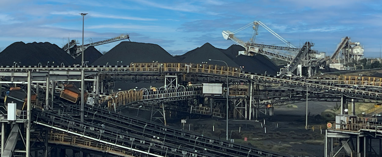
Coal handling and processing facility with multiple conveyors, stockpiles of coal, and stacking-reclaiming machinery operating under a blue sky

A Systems Engineering Approach for Reliable Coal Handling

In coal mining operations, transfer chutes play a deceptively small role with disproportionately large impacts. They sit quietly between conveyors, crushers, and stockpiles, directing tonnes of coal every hour. Yet when a chute is poorly designed or not maintained, the whole coal handling system suffers: blockages stop production, dust creates safety and environmental hazards, and worn liners demand costly maintenance shutdowns.

At Hamilton by Design, we believe coal chute design should be treated not as a piece of steelwork, but as a systems engineering challenge. By applying systems thinking, we connect stakeholder requirements, material behaviour, environmental factors, and lifecycle performance into a holistic design approach that delivers long-term value for mining operations in the Hunter Valley and beyond.


Coal Chutes in the Mining Value Chain

Coal chutes form the links in a chain of bulk material handling equipment:

  • ROM bins and crushers feed coal into the system.
  • Conveyors carry coal across site, often over long distances.
  • Transfer chutes guide coal between conveyors or onto stockpiles.
  • Load-out stations deliver coal to trains or ports for export.

Although they are small compared to conveyors or crushers, coal chutes are often where problems first appear. A well-designed chute keeps coal flowing consistently; a poorly designed one causes buildup, spillage, dust emissions, and accelerated wear. Thatโ€™s why leading operators now see chute design as a critical system integration problem rather than just a fabrication task.

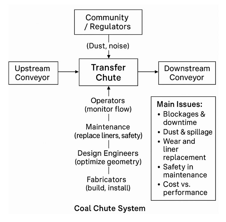
Flow diagram of a coal chute system showing upstream and downstream conveyors, the transfer chute, stakeholder interactions, and main issues such as blockages, dust, wear, maintenance safety, and cost versus performance

Systems Engineering in Coal Chute Design

Systems engineering is the discipline of managing complexity in engineering projects. It recognises that every component is part of a bigger system, with interdependencies and trade-offs. Applying this mindset to coal chute design ensures that each chute is considered not in isolation, but as part of the broader coal handling plant.

1. Requirements Analysis

The first step is gathering and analysing stakeholder and system requirements:

  • Throughput capacity: e.g. handling 4,000 tonnes per hour of coal.
  • Material properties: coal size distribution, moisture content, abrasiveness, stickiness.
  • Safety requirements: compliance with AS/NZS 4024 conveyor safety standards, confined space entry protocols, guarding, and interlocks.
  • Environmental compliance: dust, noise, and spillage limits.
  • Maintenance objectives: target liner life (e.g. 6 months), maximum downtime per liner change (e.g. 30 minutes with two workers).

A structured requirements phase reduces the risk of costly redesign later in the project.


2. System Design and Integration

Once requirements are defined, the design process considers how the chute integrates into the coal handling system:

  • Flow optimisation using DEM: Discrete Element Modelling allows engineers to simulate coal particle behaviour, test different geometries, and reduce blockages before steel is ever cut.
  • Dust control strategies: designing chutes with enclosures, sprays, and extraction ports to minimise airborne dust.
  • Wear management: predicting wear zones, selecting suitable liner materials (ceramic, Bisplate, rubber composites), and ensuring easy access for replacement.
  • Structural and safety design: ensuring the chute can withstand dynamic loads, vibration, and impact, while providing safe access platforms and guarding.
  • Interfaces with conveyors and crushers: alignment, skirt seals, trip circuits, and integration with PLC/SCADA control systems.

By treating the chute as a subsystem with multiple interfaces, designers avoid the โ€œbolt-onโ€ mentality that often leads to operational headaches.


3. Verification and Validation

The systems engineering V-model reminds us that every requirement must be verified and validated:

  • Component verification: weld inspections, liner hardness testing, nozzle spray checks.
  • Subsystem verification: chute section fit-up, guard gap measurements, coating checks.
  • Integration testing: conveyor-chute alignment, PLC spray interlocks, trip circuits.
  • System validation: commissioning with live coal flow, dust monitoring against limits, maintainability time trials for liner change.

By linking requirements directly to tests in a traceability matrix, operators can be confident that the chute is not only built to spec, but proven in operation.


Lifecycle Engineering: Beyond Installation

Good chute design doesnโ€™t stop at commissioning. A lifecycle engineering mindset ensures the chute continues to deliver performance over years of operation.

  • Maintainability: modular liners, captive fasteners, hinged access doors, and clear procedures reduce downtime and improve worker safety.
  • Reliability: DEM-informed designs and wear-resistant materials reduce the frequency of blockages and rebuilds.
  • Sustainability: dust suppression and enclosure strategies reduce environmental impact and support community and regulatory compliance.
  • Continuous improvement: feedback loops from operators and maintenance teams feed into the next design iteration, closing the systems engineering cycle.

A Rich Picture of Coal Chute Complexity

Visualising the coal chute system as a rich picture reveals its complexity:

  • Operators monitoring flow from control rooms.
  • Maintenance crews working in confined spaces, replacing liners.
  • Design engineers using DEM simulations to model coal flow.
  • Fabricators welding heavy plate sections on site.
  • Environmental officers measuring dust levels near transfer points.
  • Regulators and community monitoring compliance.

This web of relationships shows why coal chute design benefits from systems thinking. No single stakeholder sees the whole pictureโ€”but systems engineering does.


Benefits of a Systems Engineering Approach

When coal chute design is guided by systems engineering principles, operators gain:

  • Higher reliability: smoother coal flow with fewer blockages.
  • Lower maintenance costs: liners that last longer and can be swapped quickly.
  • Improved compliance: dust, spillage, and safety issues designed out, not patched later.
  • Lifecycle value: less unplanned downtime and a lower total cost of ownership.

In short, systems engineering transforms coal chutes from weak links into strong connectors in the mining value chain.


Case Study: Hunter Valley Context

In the Hunter Valley, coal mines have long struggled with transfer chute problems. Companies like T.W. Woods, Chute Technology, HIC Services, and TUNRA Bulk Solids have all demonstrated the value of combining local fabrication expertise with advanced design tools. Hamilton by Design builds on this ecosystem by applying structured systems engineering methods, ensuring each chute project balances performance, safety, cost, and sustainability.


Conclusion

Coal chute design might seem like a small detail, but in mining, details matter. When transfer chutes fail, production stops. By applying systems engineering principlesโ€”from requirements analysis and DEM modelling to verification, lifecycle planning, and continuous improvementโ€”we can design coal chutes that are reliable, maintainable, and compliant.

At Hamilton by Design, we believe in tackling these challenges with a systems mindset, delivering solutions that stand up to the realities of coal mining.


Are you struggling with coal chute blockages, dust, or costly downtime in your coal handling system?

Hamilton By Design logo displayed on a blue tilted rectangle with a grey gradient background

Contact Hamilton by Design today and discover how our systems engineering expertise in coal chute design can optimise your mining operations for performance, safety, and sustainability.

Mechanical Engineering | Structural Engineering

Mechanical Drafting | Structural Drafting

3D CAD Modelling | 3D Scanning

Chute Design

SolidWorks Contractors in Australia

Hamilton By Design โ€“ Blog

Our clients:

Name
Would you like us to arrange a phone consultation for you?
Address
Finite Element Analysis (FEA) engineering simulation button
Mechanical engineering services

Seeing the Unseen: How LiDAR Scanning is Transforming Mining Process Plants

In modern mining, where uptime is money and safety is non-negotiable, understanding the geometry of your process plant is critical. Every conveyor, chute, pipe rack, and piece of equipment must fit together seamlessly and operate reliably โ€” but plants are messy, dusty, and constantly changing. Manual measurement with a tape or total station is slow, risky, and often incomplete.

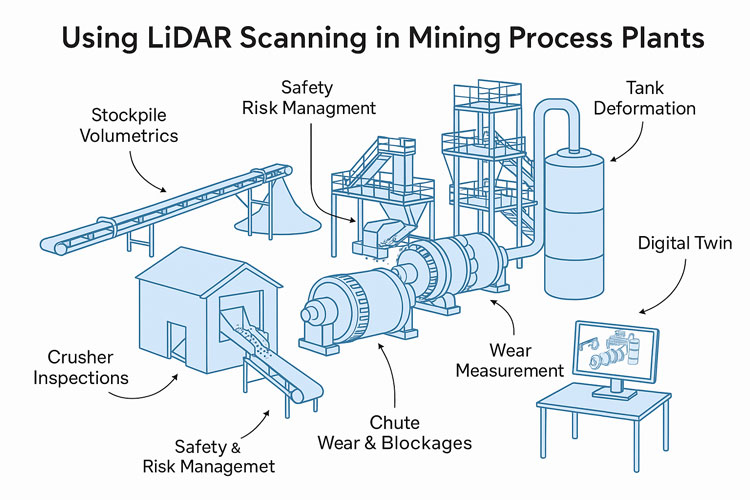
nfographic showing how LiDAR scanning is used in mining process plants, with illustrations of conveyors, crushers, tanks, mills and chutes. Labels highlight applications such as stockpile volumetrics, crusher inspections, safety and risk management, chute wear and blockages, mill wear measurement, tank deformation monitoring and creating digital twins.

This is where LiDAR scanning (Light Detection and Ranging) has become a game-changer. By capturing millions of precise 3D points per second, LiDAR gives engineers, maintenance planners, and operators an exact digital replica of the plant โ€” without climbing scaffolds or shutting down equipment. In this post, weโ€™ll explore how mining companies are using LiDAR scanning to solve real problems in processing plants, improve safety, and unlock operational efficiency.


What Is LiDAR Scanning?

LiDAR is a remote sensing technology that measures distance by firing pulses of laser light and recording the time it takes for them to return. Modern terrestrial and mobile LiDAR scanners can:

  • Capture hundreds of thousands to millions of points per second
  • Reach tens to hundreds of meters, depending on the instrument
  • Achieve millimeter-to-centimeter accuracy
  • Work in GPS-denied environments, such as inside mills, tunnels, or enclosed plants (using SLAM โ€” Simultaneous Localization and Mapping)

The output is a point cloud โ€” a dense 3D dataset representing surfaces, equipment, and structures with stunning accuracy. This point cloud can be used as-is for measurements or converted into CAD models and digital twins.


Why Process Plants Are Perfect for LiDAR

Unlike greenfield mine sites, processing plants are some of the most geometry-rich and access-constrained areas on site. They contain:

  • Complex networks of pipes, conveyors, tanks, and structural steel
  • Moving equipment such as crushers, mills, and feeders
  • Dusty, noisy, and hazardous environments with limited safe access

All these factors make traditional surveying difficult โ€” and sometimes dangerous. LiDAR enables โ€œno-touchโ€ measurement from safe vantage points, even during operation. Multiple scans can be stitched together to create a complete model without shutting down the plant.


Applications of LiDAR in Process Plants

1. Wear Measurement and Maintenance Planning

LiDAR has revolutionized how mines measure and predict wear on critical process equipment:

  • SAG and Ball Mill Liners โ€“ Portable laser scanners can capture the exact wear profile of liners. Comparing scans over time reveals wear rates, helping maintenance teams schedule relines with confidence and avoid premature failures.
  • Crusher Chambers โ€“ Scanning inside primary and secondary crushers is now faster and safer than manual inspections. The resulting 3D model allows engineers to assess liner life and optimize chamber profiles.
  • Chutes and Hoppers โ€“ Internal scans show where material buildup occurs, enabling targeted cleaning and redesign to prevent blockages.

Result: Reduced downtime, safer inspections, and better forecasting of maintenance budgets.


2. Retrofit and Expansion Projects

When modifying a plant โ€” installing a new pump, rerouting a pipe, or adding an entire circuit โ€” having an accurate โ€œas-builtโ€ model is crucial.

  • As-Built Capture โ€“ LiDAR provides an exact snapshot of the existing plant layout, eliminating guesswork.
  • Clash Detection โ€“ Designers can overlay new equipment models onto the point cloud to detect interferences before anything is fabricated.
  • Shutdown Optimization โ€“ With accurate geometry, crews know exactly what to cut, weld, and install โ€” reducing surprise field modifications and shortening shutdown durations.

3. Inventory and Material Flow Monitoring

LiDAR is not just for geometry โ€” itโ€™s also a powerful tool for tracking material:

  • Stockpile Volumetrics โ€“ Mounted scanners on stackers or at fixed points can monitor ore, concentrate, and product stockpiles in real time.
  • Conveyor Load Measurement โ€“ Stationary LiDAR above belts calculates volumetric flow, giving a direct measure of throughput without contact.
  • Blending Control โ€“ Accurate inventory data improves blending plans, ensuring consistent plant feed quality.

4. Safety and Risk Management

Perhaps the most valuable application of LiDAR is keeping people out of harmโ€™s way:

  • Hazardous Floor Areas โ€“ When flooring or gratings fail, robots or drones with LiDAR payloads can enter the area and collect data remotely.
  • Fall-of-Ground Risk โ€“ High walls, bin drawpoints, and ore passes can be scanned for unstable rock or buildup.
  • Escape Route Validation โ€“ Scans verify clearances for egress ladders, walkways, and platforms.

Every scan effectively becomes a permanent digital record โ€” a baseline for monitoring ongoing structural integrity.


5. Digital Twins and Advanced Analytics

A plant-wide LiDAR scan is the foundation of a digital twin โ€” a living, data-rich 3D model connected to operational data:

  • Combine scans with SCADA, IoT, and maintenance systems
  • Visualize live process variables in context (flow rates, temperatures, vibrations)
  • Run โ€œwhat-ifโ€ simulations for debottlenecking or energy optimization

As AI and simulation tools mature, the combination of geometric fidelity and operational data opens new possibilities for predictive maintenance and autonomous plant operations.


Emerging Opportunities

Looking forward, there are several promising areas for LiDAR in mining process plants:

  • Autonomous Scan Missions โ€“ Using quadruped robots (like Spot) or SLAM-enabled drones to perform routine scanning in high-risk zones.
  • Real-Time Change Detection โ€“ Continuous scanning of critical assets with alerts when deformation exceeds thresholds.
  • AI-Driven Point Cloud Analysis โ€“ Automatic object recognition (valves, flanges, motors) to speed up model creation and condition reporting.
  • Integrated Planning Dashboards โ€“ Combining LiDAR scans, work orders, and shutdown schedules in a single interactive 3D environment.

Best Practices for Implementing LiDAR

To maximize the value of LiDAR scanning, consider:

  1. Define the Objective โ€“ Are you measuring wear, planning a retrofit, or building a digital twin? This affects scanner choice and resolution.
  2. Plan Scan Positions โ€“ Minimize occlusions and shadow zones by preplanning vantage points.
  3. Use Proper Registration โ€“ Tie scans to a control network for consistent alignment between surveys.
  4. Mind the Environment โ€“ Dust, fog, and vibration can degrade data; choose scanners with appropriate filters or protective housings.
  5. Invest in Processing Tools โ€“ The raw point cloud is only the start โ€” software for meshing, modeling, and analysis is where value is extracted.
  6. Train Your Team โ€“ Build internal capability for scanning, processing, and interpreting the results to avoid vendor bottlenecks.

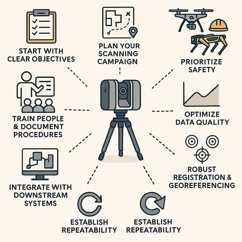
Infographic showing a 3D LiDAR scanner on a tripod surrounded by eight best-practice principles: start with clear objectives, plan your scanning campaign, prioritize safety, optimize data quality, ensure robust registration and georeferencing, establish repeatability, integrate with downstream systems, and train people with documented procedures

LiDAR scanning is no longer a niche technology โ€” it is rapidly becoming a standard tool for mining process plants that want to operate safely, efficiently, and with fewer surprises. From mill liners to stockpiles, from shutdown planning to digital twins, LiDAR provides a clear, measurable view of assets that was impossible a decade ago.

For operations teams under pressure to deliver more with less, the case is compelling: better data leads to better decisions. And in a high-stakes environment like mineral processing, better decisions translate directly to improved uptime, reduced costs, and safer workplaces.

The next time youโ€™re planning a shutdown, a retrofit, or even just trying to understand why a chute is plugging, consider pointing a LiDAR scanner at the problem. You may be surprised at how much more you can see โ€” and how much time and money you can save.

3D Scanning | Mining Surface Ops | 3D Modelling

Mechanical Engineering | Structural Engineering

Mechanical Drafting | Structural Drafting

3D CAD Modelling | 3D Scanning

Chute Design

SolidWorks Contractors in Australia

Hamilton By Design โ€“ Blog

Finite Element Analysis (FEA) engineering simulation button
Mechanical engineering services

Chute Design in the Mining Industry

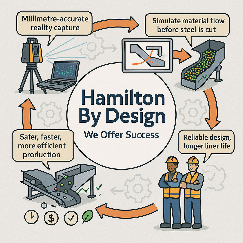
Infographic showing Hamilton By Designโ€™s engineering workflow, including millimetre-accurate LiDAR reality capture, material-flow simulation, optimised chute designs, and safer, more efficient production outcomes. Two workers in PPE highlight reliable design and longer liner life, with icons representing time, cost and quality benefits.

Getting Coal, Hard Rock, and ROM Material Flow Right

Chute design is one of the most critical yet challenging aspects of mining and mineral processing. Whether you are handling coal, hard rock ore, or raw ROM material, chutes and transfer stations are the unsung workhorses of every operation. When designed well, they guide material smoothly, minimise wear, and keep conveyors running. When designed poorly, they cause blockages, spillage, excessive dust, and expensive downtime.

Modern chute design has moved far beyond rules of thumb and back-of-the-envelope sketches. Today, successful projects rely on accurate as-built data, particle trajectory analysis, and advanced Discrete Element Method (DEM) simulation to predict, visualise, and optimise material flow before steel is cut. In this article, we explore why these tools have become essential, how they work together, and where software can โ€” and cannot โ€” replace engineering judgement.


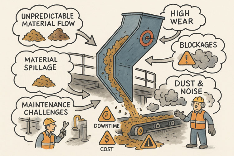
Illustration showing common problems with poorly designed material-handling chutes. A chute discharges material onto a conveyor while issues are highlighted around it: unpredictable material flow, material spillage, maintenance challenges, high wear, blockages, and dust and noise. Warning icons for downtime and cost appear on the conveyor, and workers are shown dealing with the resulting hazards and maintenance tasks.

The Challenge of Chute Design

Coal and hard rock have very different flow behaviours. Coal tends to be softer, generate more dust, and be prone to degradation, while hard rock is more abrasive and can damage chutes if impact angles are not controlled. ROM material adds another level of complexity โ€” oversize lumps, fines, and moisture variation can cause hang-ups or uneven flow.

Chute design must balance several competing objectives:

  • Control the trajectory of incoming material to reduce impact and wear
  • Prevent blockages by maintaining flowability, even with wet or sticky ore
  • Manage dust and noise to meet environmental and workplace health requirements
  • Fit within existing plant space with minimal modification to conveyors and structures
  • Be maintainable โ€” liners must be accessible and replaceable without excessive downtime

Meeting all these goals without accurate data and simulation is like trying to design in the dark.


Illustrated graphic showing a tripod-mounted 3D laser scanner capturing millimetre-accurate as-built data in an industrial plant with conveyors and walkways. Speech bubbles highlight issues such as โ€œOutdated drawings donโ€™t tell the full storyโ€ and โ€œModifications rarely get documented.โ€ The scan data is shown being visualised on a laptop, with notes describing full coverage of conveyors, walkways, and services. Benefits listed along the bottom include faster data collection, fewer site revisits, safer shutdowns, accurate starting point for design simulation, and safer outcomes that ensure designs fit first time.

Capturing the Truth with 3D Scanning

The first step in any successful chute project is to understand the as-built environment. In many operations, drawings are outdated, modifications have been made over the years, and the real plant geometry may differ from what is on paper. Manual measurement is slow, risky, and often incomplete.

This is where 3D laser scanning changes the game. Using tripod-mounted or mobile LiDAR scanners, engineers can capture the entire transfer station, conveyors, surrounding steelwork, and services in a matter of hours. The result is a dense point cloud with millimetre accuracy that reflects the true state of the plant.

From here, the point cloud is cleaned and converted into a 3D model. This ensures the new chute design will not clash with existing structures, and that all clearances are known. It also allows maintenance teams to plan safe access for liner change-outs and other work, as the scanned model can be navigated virtually to check reach and access envelopes.


Understanding Particle Trajectory

Once the physical environment is known, the next challenge is to understand the particle trajectory โ€” the path that material takes as it leaves the head pulley or previous transfer point.

Trajectory depends on belt speed, material characteristics, and discharge angle. For coal, fine particles may spread wider than the coarse fraction, while for ROM ore, large lumps may follow a ballistic path that needs to be controlled to prevent impact damage.

Accurately modelling trajectory ensures that the material enters the chute in the right location and direction. This minimises impact forces, reducing wear on liners and avoiding the โ€œsplashโ€ that creates spillage and dust. It also prevents the material from hitting obstructions or dead zones that could lead to build-up and blockages.

Modern software can plot the trajectory curve for different loading conditions, providing a starting point for chute geometry. This is a critical step โ€” if the trajectory is wrong, the chute design will be fighting against the natural path of the material.


The Power of DEM Simulation

While trajectory gives a first approximation, real-world flow is far more complex. This is where Discrete Element Method (DEM) simulation comes into play. DEM models represent bulk material as thousands (or millions) of individual particles, each following the laws of motion and interacting with one another.

When a DEM simulation is run on a chute design:

  • You can visualise material flow in 3D, watching how particles accelerate, collide, and settle
  • Impact zones become clear, showing where liners will wear fastest
  • Areas of turbulence, dust generation, or segregation are identified
  • Build-up points and potential blockages are predicted

This allows engineers to experiment with chute geometry before fabrication. Angles can be changed, ledges removed, and flow-aiding features like hood and spoon profiles or rock-boxes optimised to achieve smooth, controlled flow.

For coal, DEM can help ensure material lands gently on the receiving belt, reducing degradation and dust. For hard rock, it can ensure that the energy of impact is directed onto replaceable wear liners rather than structural plate. For ROM ore, it can help prevent oversize lumps from wedging in critical locations.


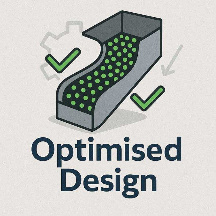
Illustration of an optimised chute design showing material flow represented by green particles, with check marks and gear icons indicating improved efficiency and engineered performance.

๐Ÿ–ฅ Strengths and Limitations of Software

Modern DEM packages are powerful, but they are not magic. Software such as EDEM, Rocky DEM, or Altairโ€™s tools can simulate a wide range of materials and geometries, but they rely on good input data and skilled interpretation.

Key strengths include:

  • Ability to model complex, 3D geometries and particle interactions
  • High visualisation power for communicating designs to stakeholders
  • Capability to run multiple scenarios (different feed rates, moisture contents, ore types) quickly

However, there are limitations:

  • Material calibration is critical. If the particle shape, friction, and cohesion parameters are wrong, the results will not match reality.
  • Computational cost can be high โ€” detailed simulations of large chutes with millions of particles may take hours or days to run.
  • Engineering judgement is still needed. Software will not tell you the โ€œbestโ€ design โ€” it will only show how a proposed design behaves under given conditions.

Thatโ€™s why DEM is best used as part of a holistic workflow that includes field data, trajectory analysis, and experienced design review.


From Model to Real-World Results

When the simulation results are validated and optimised, the design can be finalised. The point cloud model ensures the chute will fit in the available space, and the DEM results give confidence that it will perform as intended.

This means fabrication can proceed with fewer changes and less risk. During shutdown, installation goes smoothly, because clashes have already been resolved in the digital model. Once commissioned, the chute delivers predictable flow, less spillage, and longer liner life.


Why It Matters More Than Ever

Todayโ€™s mining operations face tighter production schedules, stricter environmental compliance, and increasing cost pressures. Downtime is expensive, and the margin for error is shrinking.

By combining 3D scanning, trajectory modelling, and DEM simulation, operations can move from reactive problem-solving to proactive improvement. Instead of waiting for blockages or failures, they can design out the problems before they occur, saving both time and money.


Partnering for Success

At Hamilton by Design, we specialise in turning raw site data into actionable insights. Our team uses advanced 3D scanning to capture your transfer stations with precision, builds accurate point clouds and CAD models, and runs calibrated DEM simulations to ensure your new chute design performs from day one.

Whether youโ€™re working with coal, hard rock, or ROM ore, we help you deliver designs that fit first time, reduce maintenance headaches, and keep production running.

Contact us today to see how our integrated scanning and simulation workflow can make your next chute project safer, faster, and more reliable.

Mechanical Engineering | Structural Engineering

Mechanical Drafting | Structural Drafting

3D Laser Scanning | 3D CAD Modelling | 3D Scanning

Chute Design

SolidWorks Contractors in Australia

Hamilton By Design โ€“ Blog

Consulting Engineers

About Us โ€“ Hamilton By Design

Hamilton By Design | 3D Scanning | Sydney | Perth | Brisbane | Mount Isa | Lidar Scanning

Contact us

https://www.hamiltonbydesign.com.au/perth-wa
3D CAD Modelling Australia service banner for Hamilton By Design
3D LiDAR scanning and 3D modelling service button โ€” laser scanner capturing a point cloud for engineering and CAD modelling
Mechanical engineering services
3D CAD Modelling Australia service banner for Hamilton By Design
Mechanical, Structural & Pipework Drafting service banner by Hamilton By Design featuring white text on a blue background.
Australian Drafting logo featuring bold white text reading "Australian Drafting" centred on a blue rounded rectangle background.
Blue banner graphic displaying the text "Point Cloud to CAD - Australia" in large white lettering, representing point cloud processing, scan-to-CAD conversion and digital engineering services across Australia.
CHPP Engineering title graphic featuring bold white text reading "CHPP Engineering" centred on a blue rounded rectangle background.
Engineering Governance title graphic featuring bold white text reading "Engineering Governance" centred on a blue rounded rectangle background.
Mechanical engineering services
Australian Drafting logo featuring bold white text reading "Australian Drafting" centred on a blue rounded rectangle background.
3D LiDAR Scanning Hunter & Newcastle banner with white text on a blue background promoting engineering-grade laser scanning services for industrial, mining and infrastructure projects across the Hunter Valley and Newcastle region.
Mechanical Engineering Hunter & Newcastle banner promoting mechanical engineering services for mining, industrial plants, power generation, manufacturing and heavy industry throughout the Hunter Valley and Newcastle region.
Structural Drafting Hunter & Newcastle banner promoting structural drafting services for mining, industrial plants, power generation, manufacturing and infrastructure projects across the Hunter Valley and Newcastle region.
Mechanical Engineering Perth WA banner for Hamilton By Design featuring white text on a blue background.
3D Laser Scanning Perth WA banner for Hamilton By Design with white text on a blue background.
SolidWorks Perth WA banner for Hamilton By Design featuring white text on a blue background.
Fabrication and product design services
Finite Element Analysis (FEA) engineering simulation button
3D LiDAR scanning and 3D modelling service button โ€” laser scanner capturing a point cloud for engineering and CAD modelling
Blue rounded button with the text โ€œSolidWorks Designโ€ in white.
Mechanical drafting services button
Structural drafting services button

3D Scanning Sydney banner promoting engineering-grade 3D laser scanning, LiDAR scanning, and reality capture services by Hamilton By Design.
Mechanical Engineering Sydney banner with white text on a blue background representing Hamilton By Design's mechanical engineering services in Sydney.
Mechanical Drafting and 3D Modelling Sydney banner highlighting Hamilton By Design's CAD drafting, 3D modelling, and engineering design services in Sydney.

Mechanical Engineering | Structural Engineering