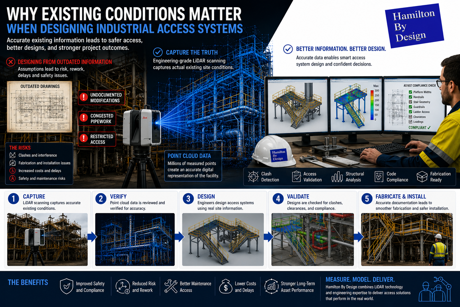
Why Existing Conditions Matter When Designing Industrial Access Systems

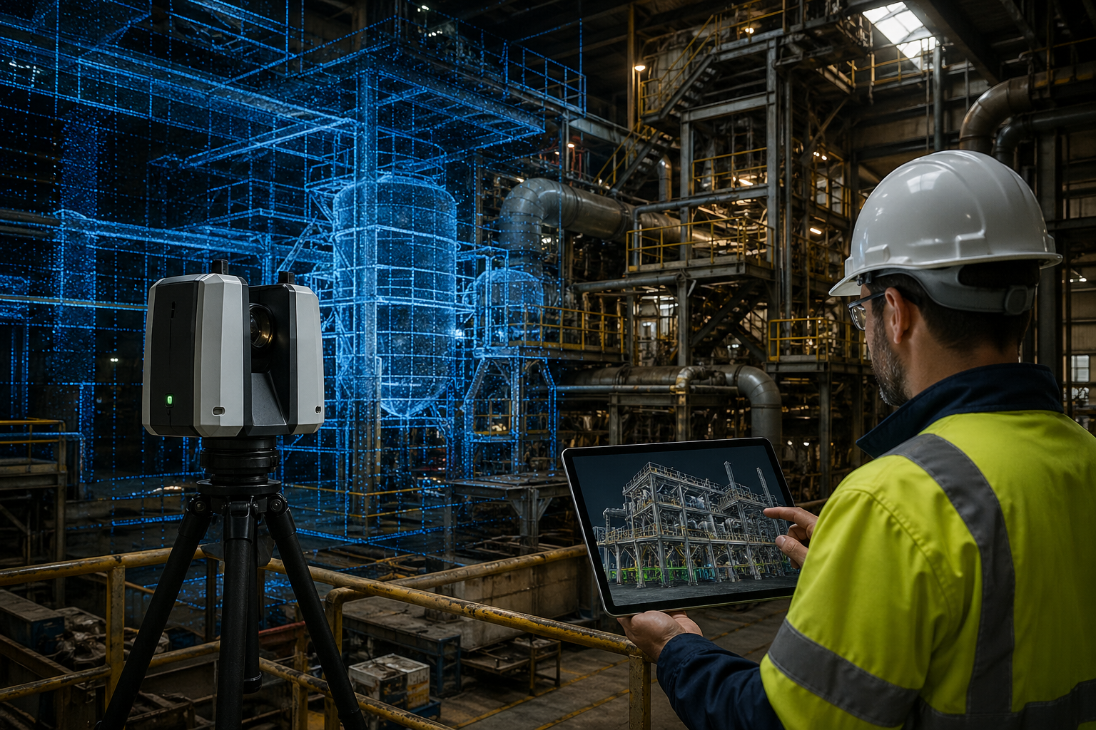
Engineering-grade LiDAR scanning and CAD workflow showing existing condition capture for industrial access system design.

Industrial access systems are often viewed as secondary structures within a facility. Platforms, walkways, stairways, and ladders are frequently designed around existing equipment after primary process systems have already been established.

However, in industrial environments, access systems directly influence:

  • Worker safety
  • Maintenance efficiency
  • Equipment accessibility
  • Shutdown activities
  • Project cost
  • Long-term operational performance

When new access systems are designed using assumptions or outdated information, project teams can unknowingly introduce significant risk.

At Hamilton By Design, engineering decisions begin with understanding one important factor:

What actually exists on site today?

Existing condition capture provides measured information that supports safer, more efficient access system design.

Why Existing Conditions Matter

Industrial facilities rarely remain unchanged over their operational life.

Over time sites commonly experience:

  • Equipment upgrades
  • Structural modifications
  • Additional pipework
  • Maintenance repairs
  • Temporary installations becoming permanent
  • New process equipment
  • Historical undocumented changes

As facilities evolve, original engineering documentation can gradually become disconnected from actual site conditions.

This creates challenges when developing:

  • New platforms
  • Walkways
  • Stairways
  • Ladders
  • Handrails
  • Maintenance access systems

Designing around incorrect information can create downstream issues during fabrication and installation.

Risks of Designing Around Assumptions

Even relatively small dimensional differences can create larger problems during construction activities.

Potential issues may include:

Restricted Maintenance Access

Poorly positioned access systems can create:

  • Congested work areas
  • Difficult equipment access
  • Manual handling risks
  • Longer maintenance durations

Structural Interference

Undocumented changes can result in:

  • Platform clashes
  • Pipework conflicts
  • Equipment interference
  • Structural rework

Installation Difficulties

Fabricated structures designed from inaccurate information may require:

  • Site modification
  • Additional labour
  • Rework
  • Schedule changes

Safety Risks

Poor access layouts can increase:

  • Working at height exposure
  • Congested access routes
  • Maintenance hazards
  • Human factors risks
3D CAD Modelling Australia service banner for Hamilton By Design

Brownfield Facilities Create Additional Challenges

Brownfield environments are often significantly different from greenfield projects.

Typical challenges include:

  • Congested plant layouts
  • Existing structures
  • Legacy equipment
  • Historical modifications
  • Limited clearances
  • Restricted access areas

In many facilities, existing drawings may not accurately represent the current operating environment.

Designing access systems without verified information increases project uncertainty.

Existing Condition Capture Through Engineering-Grade LiDAR Scanning

Hamilton By Design supports industrial projects using engineering-grade 3D LiDAR scanning to capture actual site geometry.

Scanning may capture:

  • Structural steel
  • Existing platforms
  • Walkways
  • Pipework
  • Equipment
  • Access systems
  • Buildings
  • Operating environments

Rather than relying solely on manual measurements, engineers gain measurable spatial information.

Benefits can include:

  • Existing condition verification
  • Improved accuracy
  • Reduced assumptions
  • Reduced installation risk
  • Improved project confidence

From Point Clouds to Access System Design

Once site information is captured, scan data can be converted into engineering information through Scan-to-CAD workflows.

This allows development of:

  • Existing condition models
  • Platform layouts
  • Access systems
  • Stairways
  • Structural designs
  • Fabrication drawings

Potential issues can be identified digitally before fabrication begins.

Improving Maintenance Access

Access systems should support how equipment is maintained, not simply how equipment is installed.

Maintenance activities commonly require:

  • Equipment removal space
  • Inspection access
  • Safe movement paths
  • Tool handling areas
  • Shutdown activities

Considering these requirements early can improve:

  • Safety performance
  • Maintenance efficiency
  • Downtime reduction
  • Long-term asset performance

Supporting Engineering Compliance

Access system design frequently involves consideration of standards including:

  • AS1657 โ€“ Fixed Platforms, Walkways, Stairways and Ladders
  • AS3996 โ€“ Access Covers and Grates
  • Structural loading requirements
  • Site-specific standards

Compliance becomes more effective when based on accurate existing information.

How Hamilton By Design Supports Industrial Access Projects

Hamilton By Design supports industrial access projects through:

  • Engineering-grade 3D LiDAR scanning
  • Existing condition capture
  • Scan-to-CAD workflows
  • Mechanical and structural design
  • Engineering analysis and simulation
  • CAD modelling
  • Fabrication documentation

The objective is not simply designing platforms.

The objective is creating access systems that support safety, maintenance activities, and operational performance.


3D LiDAR scanning and 3D modelling service button โ€” laser scanner capturing a point cloud for engineering and CAD modelling
Mechanical engineering services

Moving Beyond Assumptions

Industrial facilities evolve over time.

Successful access systems should be designed around what exists today rather than what historical drawings suggest exists.

Better existing condition information supports better engineering decisions.

Hamilton By Design logo displayed on a blue tilted rectangle with a grey gradient background

Name
Would you like us to arrange a phone consultation for you?
Address
Finite Element Analysis (FEA) engineering simulation button
Mechanical engineering services

Engineering Analysis & Simulation: Turning Engineering Assumptions into Measured Decisions

Engineering Analysis and Simulation infographic showing LiDAR scanning, scan-to-CAD workflows, finite element analysis (FEA), and digital engineering processes used to optimise industrial plant design and improve project outcomes.

In modern engineering projects, assumptions can quickly become expensive. Whether designing a transfer chute, assessing a structural support frame, modifying a conveyor system, or evaluating equipment performance, understanding how a system will behave before fabrication or installation can reduce risk, minimise rework, and improve project outcomes.

Engineering analysis and simulation allow engineers to move beyond simple calculations and create a deeper understanding of how equipment, structures, and systems will perform under real operating conditions.

At Hamilton By Design, we provide engineering analysis and simulation services to support mining, manufacturing, infrastructure, and industrial projects by combining engineering judgement with digital engineering tools and practical industry experience.

What is Engineering Analysis and Simulation?

Engineering analysis and simulation involve creating mathematical and digital representations of real-world systems to predict behaviour and performance before implementation.

Examples include:

  • Structural analysis
  • Finite Element Analysis (FEA)
  • Stress and deflection assessment
  • Equipment performance modelling
  • Load analysis
  • Materials handling analysis
  • Mechanical design validation
  • Existing asset assessments
  • Failure investigations
  • Brownfield modification studies

Rather than relying solely on assumptions or conservative estimates, simulation can provide measurable engineering data to support decision making.

Why Engineering Analysis Matters

Engineering projects often involve balancing multiple competing factors:

  • Safety
  • Cost
  • Performance
  • Weight
  • Reliability
  • Manufacturability
  • Maintenance access
  • Project schedule

Without engineering analysis, projects can encounter:

  • Unexpected structural failures
  • Excessive equipment wear
  • Over-designed systems
  • Fabrication clashes
  • Higher maintenance costs
  • Delays during installation

Simulation allows these issues to be identified earlier in the project lifecycle.

Hamilton By Design Engineering Analysis Services

Hamilton By Design offers engineering analysis and simulation services integrated with practical engineering workflows and reality capture technologies.

Our services can include:

Finite Element Analysis (FEA)

FEA can be used to assess:

  • Structural loading
  • Stress concentrations
  • Deflection
  • Equipment supports
  • Platform structures
  • Mechanical components
  • Existing assets

This allows engineers to identify areas of concern before fabrication or installation.

3D CAD Modelling Australia service banner for Hamilton By Design

Mechanical Design Validation

Engineering models can be assessed against:

  • Expected operational loads
  • Serviceability requirements
  • Design standards
  • Fatigue considerations
  • Practical operating conditions

Scan-to-Analysis Workflows

Traditional analysis often starts with assumptions about existing conditions.

Hamilton By Design can integrate:

  • Engineering-grade LiDAR scanning
  • Point cloud capture
  • Existing condition verification
  • Scan-to-CAD workflows

This allows simulations to be based on actual site geometry rather than estimated dimensions.

For brownfield mining and industrial projects this can significantly reduce uncertainty.

Applications Across Industry

Engineering analysis and simulation can support:

Mining

  • Conveyor systems
  • Transfer chutes
  • Processing equipment
  • Structural platforms
  • Plant modifications
  • Shutdown planning

Manufacturing

  • Production equipment
  • Structural supports
  • Machine layouts
  • Fabrication design

Infrastructure

  • Existing asset modifications
  • Structural assessments
  • Mechanical systems
  • Upgrade projects

Moving Beyond Assumptions

One of the biggest advantages of digital engineering is moving from:

Estimated geometry โ†’ Verified geometry

Rather than assuming dimensions from old drawings or field measurements, engineering analysis can be built around actual conditions captured through reality capture and CAD workflows.

This creates:

  • Improved confidence
  • Reduced project risk
  • Better fabrication outcomes
  • Reduced rework
  • More reliable project delivery
3D LiDAR scanning and 3D modelling service button โ€” laser scanner capturing a point cloud for engineering and CAD modelling
Mechanical engineering services

Supporting Better Engineering Decisions

At Hamilton By Design, engineering analysis is not treated as an isolated activity. It becomes part of a broader engineering workflow combining:

  • LiDAR scanning
  • Scan-to-CAD conversion
  • Mechanical design
  • Engineering documentation
  • Simulation and analysis
  • Project delivery support

The objective is not simply creating models. The objective is delivering engineering information that supports practical decisions and better outcomes.

Engineering analysis and simulation help projects move beyond assumptions and toward measurable, evidence-based engineering decisions.

Name
Would you like us to arrange a phone consultation for you?
Address

Our clients:

3D CAD Modelling Australia service banner for Hamilton By Design
Australian Drafting logo featuring bold white text reading "Australian Drafting" centred on a blue rounded rectangle background.
Engineering Governance title graphic featuring bold white text reading "Engineering Governance" centred on a blue rounded rectangle background.
Mechanical, Structural & Pipework Drafting service banner by Hamilton By Design featuring white text on a blue background.
Mechanical engineering services
Blue rounded button with the text โ€œSolidWorks Designโ€ in white.
Finite Element Analysis (FEA) engineering simulation button
3D LiDAR Scanning Darwin for engineering surveys, laser scanning, reality capture and point cloud modelling services
3D LiDAR Scanning Australia engineering services for laser scanning, reality capture, scan-to-CAD, Scan-to-BIM and as-built documentation across Australia
3D LiDAR scanning services on the Central Coast providing engineering-grade laser scanning, point cloud capture, scan-to-CAD modelling and industrial reality capture for infrastructure and industrial projects.
3D LiDAR Scanning Perth for engineering surveys, laser scanning, reality capture and point cloud modelling services
3D LiDAR Scanning Sydney for engineering surveys, laser scanning, reality capture and point cloud modelling services
3D LiDAR Scanning Brisbane for engineering surveys, laser scanning, reality capture and point cloud modelling services
3D LiDAR Scanning Canberra for engineering surveys, laser scanning, reality capture and point cloud modelling services
3D LiDAR Scanning Newcastle for engineering surveys, laser scanning, reality capture and point cloud modelling services
3D LiDAR Scanning Adelaide for engineering surveys, laser scanning, reality capture and point cloud modelling services

Engineering and 3D LiDAR Scanning Services in Prineville, Oregon

Prineville, Oregon has a long industrial history built around timber, forestry, sawmills, and manufacturing. While the region is now recognised internationally for technology infrastructure and data centres, the timber and wood processing industries continue to play a major role in the local economy and industrial landscape.

Across sawmills, woodworking facilities, manufacturing plants, and industrial operations, companies are under increasing pressure to improve safety, reduce downtime, modernise aging infrastructure, and maintain accurate engineering documentation.

This is where Hamilton By Design Co. can assist.

Hamilton By Design Co. provides engineer-led 3D LiDAR scanning, scan-to-CAD services, structural drafting, mechanical engineering support, and industrial digital engineering workflows for timber processing facilities, woodworking operations, industrial plants, and manufacturing infrastructure.

By combining engineering knowledge with high-accuracy terrestrial LiDAR scanning technology, Hamilton By Design helps companies reduce project risk, improve fabrication accuracy, and develop reliable as-built documentation for maintenance, shutdowns, plant upgrades, and future expansion projects.

Many timber mills and woodworking facilities contain highly mechanical environments involving:

  • conveyors,
  • transfer systems,
  • saw lines,
  • material handling systems,
  • dust extraction infrastructure,
  • hydraulic equipment,
  • structural steel platforms,
  • rotating machinery,
  • and processing equipment.

Over decades of operation, many industrial facilities evolve through ongoing modifications, maintenance activities, and equipment replacements. In many cases, original drawings no longer reflect actual onsite conditions.

3D CAD Modelling Australia service banner for Hamilton By Design

This creates significant engineering and commercial risks when companies attempt to:

  • install new machinery,
  • modify conveyors,
  • replace structural steel,
  • increase production capacity,
  • redesign transfer systems,
  • or upgrade processing infrastructure.

Outdated or inaccurate drawings can result in:

  • fabrication clashes,
  • installation delays,
  • increased labour costs,
  • shutdown overruns,
  • safety concerns,
  • and costly rework onsite.

Hamilton By Design assists companies by capturing engineering-grade point cloud data using terrestrial 3D LiDAR scanning systems. Instead of relying on manual measurements or outdated PDFs, industrial facilities can be digitally captured with millimetre-level accuracy before engineering or fabrication work begins.

Unlike low-cost visual-only scanning services, Hamilton By Design operates as an engineer-led organisation focused on practical industrial and fabrication outcomes.

Using engineering-grade terrestrial LiDAR scanning equipment, facilities can be scanned to support:

  • sawmill upgrades,
  • conveyor redesigns,
  • mechanical modifications,
  • structural steel alterations,
  • equipment replacements,
  • dust extraction upgrades,
  • and brownfield shutdown projects.

Captured point cloud data can then be converted into:

  • 3D CAD models,
  • as-built layouts,
  • fabrication drawings,
  • structural steel models,
  • mechanical assemblies,
  • engineering sections and elevations,
  • and controlled documentation packages.

For timber mills and woodworking facilities, this provides a more reliable engineering foundation for maintenance planning, fabrication, construction, and operational upgrades.

The woodworking and timber industries contain significant operational and mechanical risks. Equipment failures involving conveyors, saw systems, platforms, guarding, lifting systems, or structural supports can create serious safety consequences if engineering design, modifications, or fabrication are not properly managed.

Hamilton By Design supports companies through:

  • accurate site measurement,
  • engineering-grade scanning,
  • structural and mechanical drafting,
  • engineering modelling,
  • and controlled engineering documentation systems.

Modern engineering workflows increasingly rely on:

  • accurate as-built data,
  • finite element analysis (FEA),
  • controlled revision systems,
  • and engineering governance platforms

to ensure modifications are properly documented and validated before installation.

Using technologies such as:

  • terrestrial LiDAR scanning,
  • SolidWorks 3D modelling,
  • engineering simulation tools,
  • and the 3DEXPERIENCE platform,

project teams can better understand loading conditions, structural interactions, fabrication requirements, and installation constraints before work proceeds onsite.

This helps reduce engineering uncertainty while improving safety, planning accuracy, and project coordination.

Hamilton By Design can also assist companies operating within brownfield industrial environments where construction and upgrades occur around existing operational equipment.

Brownfield facilities often present challenges including:

  • restricted access,
  • undocumented modifications,
  • tight shutdown windows,
  • difficult measurement conditions,
  • and limited historical engineering information.

Through engineer-led scanning and digital engineering workflows, Hamilton By Design supports:

  • shutdown planning,
  • point cloud registration,
  • scan-to-CAD conversion,
  • equipment modelling,
  • and engineering drawing development.

This allows engineers, fabricators, and project managers to work from accurate digital representations of the facility rather than assumptions or incomplete historical records.

For timber mills, woodworking facilities, and industrial plants in Prineville, this can significantly improve:

  • fabrication accuracy,
  • installation efficiency,
  • shutdown coordination,
  • and project delivery outcomes.

Hamilton By Design can support industrial facilities with:

  • conveyor engineering,
  • transfer chute layouts,
  • structural steel drafting,
  • equipment support structures,
  • maintenance platforms,
  • pipework drafting,
  • access systems,
  • and mechanical design support.

By integrating point cloud data directly into the engineering workflow, new infrastructure can be designed within the context of actual site conditions.

This is particularly valuable in older forestry and industrial facilities where:

  • tolerances are tight,
  • access is restricted,
  • and existing drawings may no longer reflect reality.

As industrial facilities continue modernising, engineering governance and drawing control are becoming increasingly important. Many projects now require controlled revision systems, audit-ready documentation, and accurate digital engineering records.

Hamilton By Design supports structured engineering workflows through:

  • controlled drawing revisions,
  • digital engineering management,
  • engineering document governance,
  • and coordinated CAD environments.

This assists companies in maintaining:

  • accurate as-built drawings,
  • traceable engineering changes,
  • controlled fabrication information,
  • and long-term digital asset records.

For industrial facilities in Prineville, this supports safer operations, improved maintenance planning, and more efficient future expansion projects.

As Prineville continues growing across timber processing, forestry, manufacturing, industrial infrastructure, and technology sectors, the demand for accurate engineering information will continue increasing.

Hamilton By Design combines:

  • engineering expertise,
  • industrial plant knowledge,
  • terrestrial LiDAR scanning,
  • 3D CAD modelling,
  • and engineering governance systems

to support safer and more efficient industrial project delivery.

Hamilton By Design logo displayed on a blue tilted rectangle with a grey gradient background

Whether assisting with a timber mill upgrade, woodworking facility expansion, conveyor modification, shutdown project, structural steel redesign, or industrial mechanical installation, engineer-led 3D scanning provides a practical pathway toward improved engineering accuracy, reduced project risk, and more reliable long-term infrastructure management.

3D LiDAR scanning and 3D modelling service button โ€” laser scanner capturing a point cloud for engineering and CAD modelling
Mechanical engineering services
3D LiDAR Scanning Darwin for engineering surveys, laser scanning, reality capture and point cloud modelling services
3D LiDAR Scanning Australia engineering services for laser scanning, reality capture, scan-to-CAD, Scan-to-BIM and as-built documentation across Australia
3D LiDAR scanning services on the Central Coast providing engineering-grade laser scanning, point cloud capture, scan-to-CAD modelling and industrial reality capture for infrastructure and industrial projects.
3D LiDAR Scanning Perth for engineering surveys, laser scanning, reality capture and point cloud modelling services
3D LiDAR Scanning Sydney for engineering surveys, laser scanning, reality capture and point cloud modelling services
3D LiDAR Scanning Brisbane for engineering surveys, laser scanning, reality capture and point cloud modelling services
3D LiDAR Scanning Canberra for engineering surveys, laser scanning, reality capture and point cloud modelling services
3D LiDAR Scanning Newcastle for engineering surveys, laser scanning, reality capture and point cloud modelling services
3D LiDAR Scanning Adelaide for engineering surveys, laser scanning, reality capture and point cloud modelling services

Brownfield Industrial Upgrades

LiDAR scanner capturing an operating industrial plant for brownfield industrial upgrade engineering and CAD modelling

Engineering-Led Design, Reality Capture, and Scan-to-CAD for Existing Assets

Brownfield industrial upgrades are where engineering risk is highest โ€” and where assumptions cost the most.

Existing plant, undocumented modifications, restricted access, and shutdown-driven timeframes demand accurate site data, practical engineering judgement, and build-ready design. At Hamilton By Design, we support brownfield upgrades through an engineering-led digital workflow that connects reality capture, scan-to-CAD, and mechanical design to deliver safer, more reliable shutdown outcomes.


3D LiDAR scanning and 3D modelling service button โ€” laser scanner capturing a point cloud for engineering and CAD modelling
Mechanical engineering services

What Defines a Brownfield Upgrade?

A brownfield upgrade involves modifying, extending, or replacing existing operational assets, often under live plant or shutdown constraints.

Typical challenges include:

  • Incomplete or outdated drawings
  • Limited physical access for verification
  • Interfaces with existing structures and services
  • Shutdown windows measured in days, not weeks

These conditions make engineering-led verification essential before design and fabrication begin.


Engineering-Led Reality Capture for Existing Plant

Hamilton By Design uses engineering-grade 3D LiDAR scanning to capture existing conditions accurately, even in complex and congested environments.

This approach allows engineering teams to:

  • Verify as-built conditions without repeated site access
  • Identify clashes and interferences early
  • Design upgrades that fit first time
  • Reduce exposure hours in live plant environments

Reality capture becomes a risk-reduction tool, not just a documentation exercise.


Typical Brownfield Assets We Support

Brownfield upgrades frequently focus on high-wear, high-risk interfaces within industrial and mining facilities.

Hoppers & Chutes

  • ROM hoppers and surge bins
  • Transfer chutes and discharge transitions
  • Wear-prone interfaces and liners

Conveyors & Transfer Stations

  • Conveyor head and tail stations
  • Transfer points and discharge zones
  • Supporting steelwork and access structures

Pump Boxes & Process Interfaces

  • Pump boxes, sumps, and pipe interfaces
  • Structural supports and maintenance access
  • Integration with existing plant services

Vertical Shaft & Drop Structures

  • Vertical shaft hoppers
  • Ore passes and gravity-fed transfers
  • Confined and difficult-to-access assets

These assets are rarely isolated โ€” they sit within tightly constrained systems where accuracy matters.


3D CAD Modelling Australia service banner for Hamilton By Design

Scan-to-CAD: Turning Reality Into Buildable Design

Point clouds alone donโ€™t deliver projects โ€” engineering-intent models do.

Our scan-to-CAD workflows are developed specifically for:

  • Mechanical and structural design
  • Fabrication-ready detailing
  • Brownfield integration and installation sequencing

By aligning LiDAR data directly with CAD and engineering workflows, we eliminate guesswork and support fit-first-time fabrication.


Reliable Support for Shutdown-Driven Projects

Shutdowns compress months of work into days. There is no tolerance for redesign on site.

Engineering-led reality capture supports shutdown success by:

  • Allowing design to be completed well in advance
  • Supporting off-site fabrication
  • Reducing RFIs and site queries
  • Increasing the amount of work completed per shutdown

Better information means more work done with fewer resources.


Safety Is an Engineering Outcome

Safety outcomes in brownfield environments are determined during planning and design, not during installation.

Accurate site data allows engineers to:

  • Design safer access and maintenance solutions
  • Reduce hot works and re-measurement on site
  • Identify hazards before shutdown execution
  • Improve compliance with Australian Standards

Engineering-led workflows reduce risk across the entire upgrade lifecycle.


Australian Engineering Quality You Can Rely On

Hamilton By Design delivers Australian engineering know-how, grounded in practical site experience.

We donโ€™t just capture data โ€” we:

  • Understand how plant is built and maintained
  • Design with fabrication and installation in mind
  • Take responsibility for engineering outcomes

This approach differentiates us from low-cost capture services that transfer risk downstream.


How This Integrates With Our Engineering Services

Brownfield upgrade support integrates directly with our broader capabilities, including:

  • Bulk material handling engineering
  • Mining and heavy-industry mechanical design
  • Engineering-led 3D scanning and scan-to-CAD workflows

This ensures continuity from site verification through to build-ready deliverables.


Speak With an Engineer

If youโ€™re planning a brownfield upgrade involving:

  • Hoppers, chutes, or bins
  • Conveyor transfers
  • Pump boxes or process interfaces
  • Vertical shaft or gravity-fed systems
  • Shutdown-critical works

Early engineering-led verification can significantly reduce risk.

๐Ÿ‘‰ Speak with an engineer at Hamilton By Design to discuss your upgrade or shutdown requirements.

Contact Us – Talk to Us

Name
Would you like us to arrange a phone consultation for you?
Address
Hamilton By Design logo displayed on a blue tilted rectangle with a grey gradient background
CHPP Engineering title graphic featuring bold white text reading "CHPP Engineering" centred on a blue rounded rectangle background.
Pipework Drafting title graphic featuring bold white text reading "Pipework Drafting" centred on a blue rounded rectangle background.
3D LiDAR Scanning for Engineering Projects title graphic featuring bold white text on a blue rounded rectangle background.
Finite Element Analysis (FEA) engineering simulation button
Mechanical engineering services

Mechanical Engineering | Structural Engineering


Brownfield Costโ€“Benefit: Engineering Design vs Continuous Navisworks Model Maintenance

Executive Summary

In brownfield projects, the highest return comes from applying engineering design effort at the point of change, supported by accurate point cloud data, rather than continuously updating a federated model.

The practical reality is:

Invest in engineering decisions, not in maintaining a model that becomes outdated faster than the plant changes.


3D LiDAR scanning and 3D modelling service button โ€” laser scanner capturing a point cloud for engineering and CAD modelling
Mechanical engineering services

Two Approaches

1. Model Maintenanceโ€“Centric (Navisworks)

Using Autodesk Navisworks Manage as an ongoing platform:

  • Maintain a full federated model
  • Update after every site change
  • Re-run coordination and clash detection
  • Manage model alignment across disciplines

2. Engineering-Driven (Point Cloud + Targeted CAD)

Using:

  • FARO SCENE
  • SOLIDWORKS eDrawings
  • Capture and retain point cloud data as the primary asset
  • Model only what is being modified
  • Use CAD and drawings for fabrication and communication

Cost Drivers

Navisworks Model Maintenance

  • Initial model creation and federation
  • Continuous updates after modifications
  • Data conversion and reprocessing
  • Coordination meetings and clash resolution
  • Ongoing QA and model validation

Additional hidden costs include:

  • Model drift corrections
  • Rework due to mismatch with site conditions
  • Reliance on a limited number of trained users

Engineering-Driven Workflow

  • Targeted scanning where required
  • Point cloud processing and validation
  • Engineering design effort for modifications
  • Drawing and component model production

Additional benefits include:

  • Reusable scan data
  • No requirement to maintain a full plant model
  • Faster response to site-driven changes

3D CAD Modelling Australia service banner for Hamilton By Design

Benefit Comparison

Navisworks model maintenance offers strong upfront coordination, particularly in greenfield projects, but suffers from degradation over time and high ongoing cost.

Engineering-driven workflows using point cloud data provide higher long-term accuracy, faster turnaround for small changes, and better alignment with real site conditions.


Line-of-Sight Reality

Point cloud data is inherently line-of-sight dependent. This means:

  • Only visible surfaces are captured
  • Occlusions result in gaps in the dataset

This limitation exists regardless of software platform.

Importing a point cloud into Navisworks does not improve data completeness or accuracy โ€” it simply presents the same data in a different environment.


Practical Example

For a minor electrical upgrade:

Navisworks Approach

  • Update the federated model
  • Re-run coordination
  • Issue revised model
  • Proceed with installation

This introduces significant overhead for a simple task.


Engineering Approach

  • Review point cloud or site conditions
  • Confirm clearances
  • Design locally
  • Install
  • Update drawings if required

This approach is faster, lower cost, and aligned with how work is actually executed.


Where Navisworks Adds Value

Navisworks remains effective when:

  • Multiple disciplines are designing simultaneously
  • Large-scale coordination is required
  • Clash detection is critical

This typically applies to:

  • Greenfield projects
  • Major brownfield upgrades

It should be treated as a project-phase coordination tool, not a long-term data management system.


  • Use point cloud data as the primary reference
  • Maintain raw and registered datasets (e.g. E57)
  • Model only critical interfaces and new work
  • Use drawings for formal deliverables
  • Apply Navisworks selectively where coordination is required

Final Position

In brownfield environments, value is created through engineering design and decision-making, not through continuous model maintenance.


One-Line Summary

Design what youโ€™re changing. Scan what youโ€™re keeping. Donโ€™t model what you wonโ€™t maintain.

Our clients

Talk to Us – Contact Us

Name
Would you like us to arrange a phone consultation for you?
Address
CHPP Engineering title graphic featuring bold white text reading "CHPP Engineering" centred on a blue rounded rectangle background.
Pipework Drafting title graphic featuring bold white text reading "Pipework Drafting" centred on a blue rounded rectangle background.
3D LiDAR Scanning for Engineering Projects title graphic featuring bold white text on a blue rounded rectangle background.

Laser Scanning for Engineering

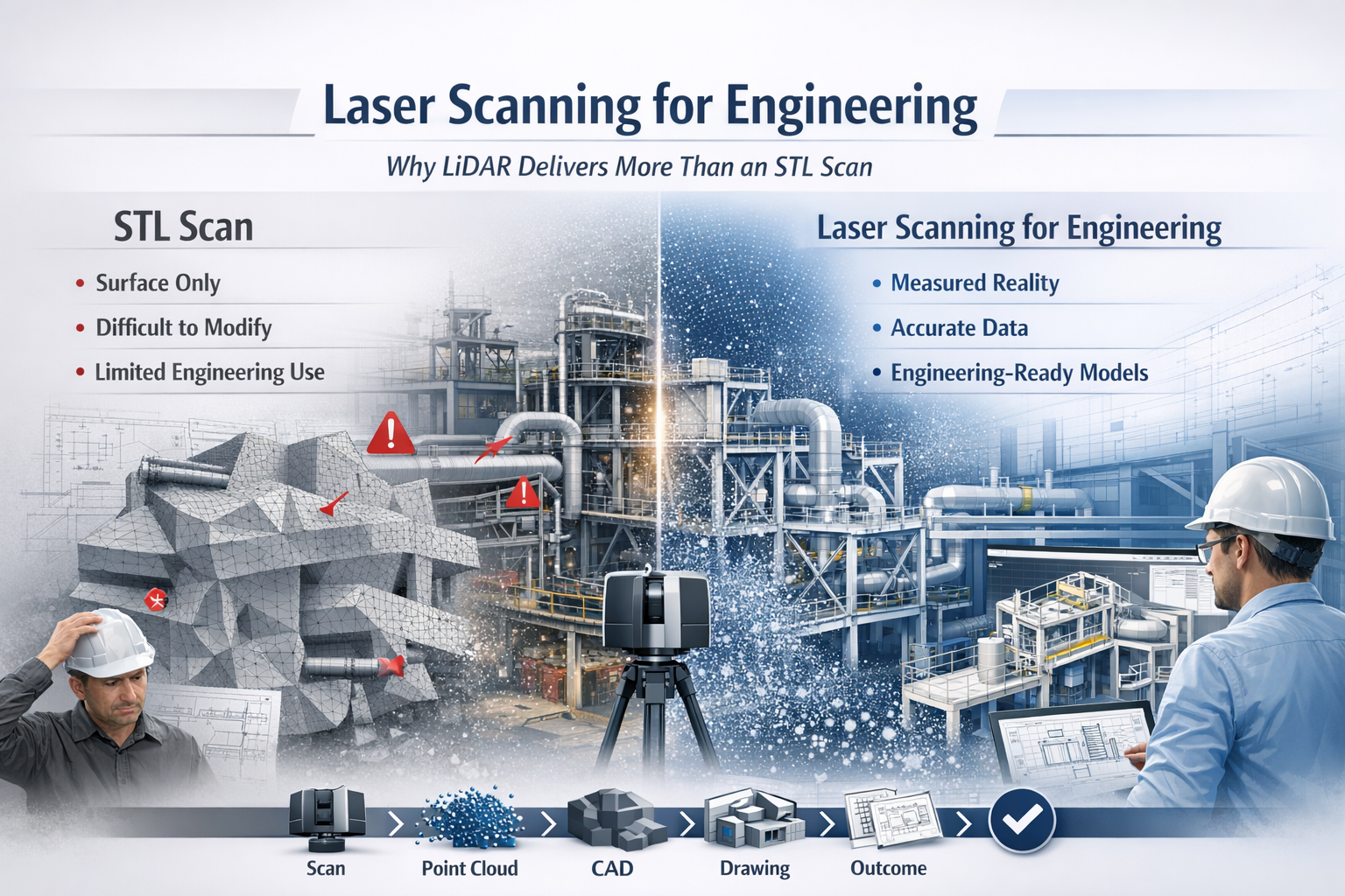
Laser scanning for engineering infographic comparing LiDAR point cloud data with STL mesh scanning, showing improved CAD modelling and engineering workflows.

Why LiDAR Delivers Real Engineering Outcomes

In modern engineering, accuracy is everything. Whether you are working in mining, manufacturing, infrastructure, or plant design, the difference between success and costly rework often comes down to how well you understand what has actually been built.

This is where laser scanning for engineering has become a critical tool.

While many providers offer โ€œ3D scanning,โ€ not all data is created equal. There is a significant difference between engineering-grade LiDAR point cloud data and basic STL mesh outputs. Understanding that difference can determine whether your project moves forward efficientlyโ€”or gets stuck in rework, assumptions, and redesign.


3D LiDAR scanning and 3D modelling service button โ€” laser scanner capturing a point cloud for engineering and CAD modelling
Mechanical engineering services

What is Laser Scanning for Engineering?

Laser scanning for engineering uses LiDAR (Light Detection and Ranging) technology to capture millions of precise measurements of a physical environment. The result is a high-density point cloudโ€”a true digital representation of reality.

Unlike traditional measurement methods, LiDAR captures:

  • Complex geometry
  • Structural relationships
  • Equipment positioning
  • Real-world deviations from design

This data becomes the foundation for:

  • CAD modelling (SolidWorks, AutoCAD, Revit)
  • Engineering drawings
  • Clash detection
  • Retrofit and upgrade design

In short, it bridges the gap between design intent and as-built reality.


The Problem with STL-Based Scanning

Many scanning providers deliver outputs as STL, OBJ, or mesh files. While these formats are useful for visualisation or 3D printing, they fall short in engineering applications.

Key limitations of STL scans:

  • No intelligence โ€“ Meshes are just surfaces, not structured geometry
  • Difficult to modify โ€“ Not suitable for parametric design workflows
  • Poor for engineering drawings โ€“ Cannot easily generate sections, tolerances, or fabrication details
  • Heavy and inefficient โ€“ Large file sizes with limited usability
  • No clear chain of accuracy โ€“ Hard to verify measurement reliability

In practical terms, an STL file often becomes a dead-end deliverableโ€”you can look at it, but you canโ€™t engineer from it effectively.


Why LiDAR Point Clouds Are Built for Engineering

LiDAR-based laser scanning for engineering produces structured, measurable, and verifiable data that integrates directly into engineering workflows.

Key advantages:

1. True-to-Reality Accuracy

Point clouds capture millions of measured points, providing a high-confidence representation of the real world.

2. Direct CAD Integration

Data can be converted into:

  • Parametric 3D models
  • Fabrication-ready drawings
  • Plant layouts and assemblies

3. Supports Engineering Decisions

Engineers can:

  • Measure directly from the dataset
  • Validate clearances and tolerances
  • Design with confidence

4. Enables Retrofit and Brownfield Design

In existing plants, nothing is ever exactly โ€œas drawn.โ€ LiDAR ensures your design fits what is actually there, not what was intended years ago.

5. Reduces Risk and Rework

Accurate input data leads to:

  • Fewer site revisits
  • Reduced fabrication errors
  • Lower project costs

6. Maintains Chain of Custody

Engineering-grade scanning supports data governance, traceability, and verificationโ€”critical in legal, compliance, and high-risk environments.


Engineering vs Visualisation: A Critical Distinction

A key misunderstanding in the industry is assuming all 3D scanning is equal.

  • STL / Mesh Scanning โ†’ Visualisation Output
  • LiDAR Point Cloud โ†’ Engineering Input

If your goal is:

  • 3D printing โ†’ STL may be enough
  • Engineering design, fabrication, or upgrades โ†’ LiDAR is essential

Real-World Application: Engineering in Practice

Across mining, manufacturing, and infrastructure, laser scanning for engineering is used to:

  • Capture conveyor systems before modification
  • Model structural steel for upgrades
  • Verify equipment installation
  • Design pipework and mechanical systems
  • Plan shutdown works with precision

Instead of guessing dimensions or relying on outdated drawings, engineers work from measured reality.


The Workflow That Delivers Results

A proper engineering workflow looks like this:

Scan โ†’ Register โ†’ Model โ†’ Detail โ†’ Deliver

Not:

Scan โ†’ Export STL โ†’ End

That difference defines whether you receive a usable engineering deliverable or just a digital artifact.


3D CAD Modelling Australia service banner for Hamilton By Design

Laser scanning for engineering is not just about capturing dataโ€”itโ€™s about enabling better engineering outcomes.

LiDAR-based point cloud data provides:

  • Accuracy
  • Usability
  • Engineering value

In contrast, STL-based scanning often limits what you can achieve.

If your project requires real design, real drawings, and real decisions, then the choice is clear:

Use laser scanning for engineeringโ€”not just scanning for appearance.

Our clients

Contact Us

Name
Would you like us to arrange a phone consultation for you?
Address
3D CAD Modelling Australia service banner for Hamilton By Design
Australian Drafting logo featuring bold white text reading "Australian Drafting" centred on a blue rounded rectangle background.
Engineering Governance title graphic featuring bold white text reading "Engineering Governance" centred on a blue rounded rectangle background.
Mechanical, Structural & Pipework Drafting service banner by Hamilton By Design featuring white text on a blue background.
Mechanical engineering services
Blue rounded button with the text โ€œSolidWorks Designโ€ in white.
Finite Element Analysis (FEA) engineering simulation button
3D LiDAR Scanning Darwin for engineering surveys, laser scanning, reality capture and point cloud modelling services
3D LiDAR Scanning Australia engineering services for laser scanning, reality capture, scan-to-CAD, Scan-to-BIM and as-built documentation across Australia
3D LiDAR scanning services on the Central Coast providing engineering-grade laser scanning, point cloud capture, scan-to-CAD modelling and industrial reality capture for infrastructure and industrial projects.
3D LiDAR Scanning Perth for engineering surveys, laser scanning, reality capture and point cloud modelling services
3D LiDAR Scanning Sydney for engineering surveys, laser scanning, reality capture and point cloud modelling services
3D LiDAR Scanning Brisbane for engineering surveys, laser scanning, reality capture and point cloud modelling services
3D LiDAR Scanning Canberra for engineering surveys, laser scanning, reality capture and point cloud modelling services
3D LiDAR Scanning Newcastle for engineering surveys, laser scanning, reality capture and point cloud modelling services
3D LiDAR Scanning Adelaide for engineering surveys, laser scanning, reality capture and point cloud modelling services