


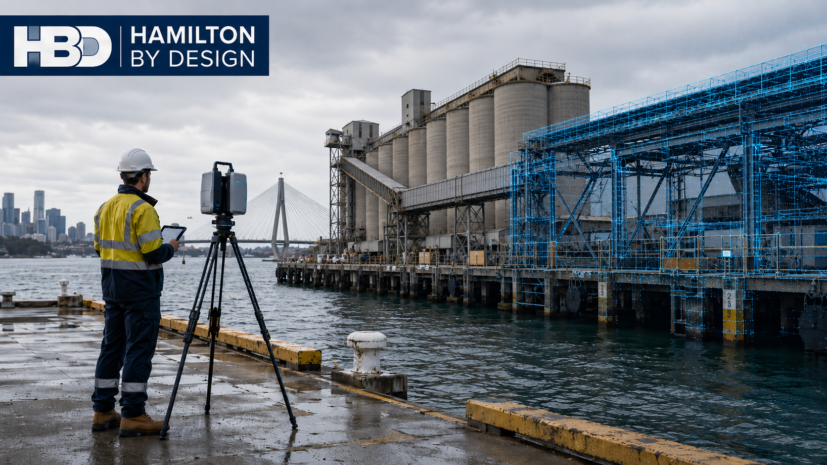
Sydney Marine Facility As-Built Surveys – Accurate Existing-Condition Data for Brownfield Engineering
Sydney’s marine infrastructure operates in a demanding environment. Wharves, berths, terminals, conveyors, ship-loading systems, pipework, access platforms, structural steel and mechanical equipment may remain in service for decades while undergoing continuous maintenance, modification and upgrading.
One of the greatest challenges for engineers working on these existing facilities is therefore remarkably simple:
Do the drawings accurately represent what is actually there?
In many brownfield marine facilities, the answer may be no.
Original construction drawings can become outdated as equipment is replaced, platforms are modified, services are rerouted, structural members are strengthened and maintenance modifications accumulate over the life of the facility. Different contractors may also produce separate drawing packages, leaving project teams with incomplete or conflicting information.
For engineering projects around Sydney’s ports, terminals and waterfront industrial facilities, accurate as-built information can therefore become an important foundation for safe, practical and buildable design.
Hamilton By Design provides Sydney Port Engineering Services combining engineering experience with modern reality-capture technology to help establish reliable existing-condition information before brownfield design work begins.
The Problem with Existing Marine Facility Drawings
Engineering drawings represent the design intent at a particular point in time.
Marine infrastructure, however, does not remain unchanged.
A facility that has operated for 10, 20 or 30 years may have undergone numerous modifications including:
- replacement mechanical equipment;
- additional structural steel;
- modified walkways and access platforms;
- new guards and safety systems;
- conveyor modifications;
- altered pipework;
- electrical and hydraulic services;
- temporary modifications that became permanent;
- corrosion repairs and strengthening works;
- changes completed during shutdowns; and
- equipment installed by different contractors.
Each individual modification may be relatively small, but collectively they can create a significant difference between the drawing archive and the physical facility.
This becomes particularly important when engineers are designing new equipment that must fit precisely around existing structures.
A few incorrect dimensions can potentially affect an entire fabrication package.
Establishing What Is Actually There
Traditional site measurement remains useful, particularly for individual components and straightforward geometry. However, measuring complex marine infrastructure using tapes, laser distance meters and individual survey points can become difficult when hundreds or thousands of dimensions are required.
Terrestrial LiDAR provides another approach.
Hamilton By Design’s 3D LiDAR scanning and 3D modelling services in Sydney can capture dense spatial information representing visible surfaces throughout an existing facility.
Multiple scanner positions can be registered together to create a coordinated three-dimensional point cloud.
Instead of recording only selected dimensions, the project team can retain a detailed digital record of the accessible existing environment at the time of scanning.
This becomes particularly valuable where design decisions may need to be revisited after the site visit.
Reality Capture for Brownfield Marine Projects
Marine facilities can contain extremely congested areas.
Structural steel, conveyors, chutes, mechanical equipment, pipework, cable trays, hydraulic systems, walkways and handrails may all occupy a relatively small volume.
Understanding these relationships from conventional two-dimensional drawings can be difficult.
Engineering-grade reality capture in Sydney provides a three-dimensional reference that allows designers to examine existing conditions from multiple viewpoints.
The point cloud can assist engineers in understanding:
- equipment position;
- structural interfaces;
- available clearances;
- access constraints;
- floor and platform levels;
- pipe routes;
- surrounding obstructions;
- connection locations; and
- potential installation pathways.
The objective is not simply to create an impressive three-dimensional image.
The real value comes from using measured spatial information to support engineering decisions.
From Point Cloud to Engineering CAD
A point cloud is fundamentally a measurement dataset.
For many engineering projects, it needs to be converted into a form that designers, engineers and fabricators can use efficiently.
Through Point Cloud to CAD Services in Sydney, relevant existing geometry can be reconstructed into CAD models and engineering drawings.
Importantly, not every object within the scan necessarily needs to be modelled.
The appropriate level of modelling should depend on the purpose of the project.
For example, a conveyor modification might require accurate modelling of:
- existing conveyor structure;
- pulley positions;
- transfer chute interfaces;
- walkways;
- surrounding structural steel;
- equipment supports; and
- potential clash zones.
Modelling unrelated objects elsewhere in the facility may provide little engineering benefit.
A fit-for-purpose approach can therefore keep the model focused on the information required for the engineering task.
Reducing Brownfield Design Uncertainty
One of the largest risks in brownfield engineering is designing new equipment around assumed existing conditions.
An engineering drawing may indicate that two columns are parallel.
The actual structure may have moved slightly.
A nominal platform level may differ from its measured position.
Pipework may have been rerouted.
A conveyor guard may have been added.
A structural brace may occupy the same location proposed for a new component.
This is where combining site capture with practical mechanical engineering services in Sydney becomes particularly useful.
Rather than separating measurement completely from engineering, the capture strategy can be developed around the downstream design problem.
Critical interfaces can be deliberately captured so the resulting dataset supports the decisions that engineers will later need to make.
Supporting Fabrication and Installation
For marine infrastructure projects, fabrication may occur many kilometres away from the operating facility.
Structural steel, platforms, chutes, guards, brackets, pipe supports and mechanical assemblies may be manufactured in a workshop before being transported to site.
Once fabrication begins, dimensional errors become increasingly expensive to correct.
If existing geometry has been incorrectly documented, the problem may only become apparent when the fabricated component reaches site.
The consequences can include:
- cutting and reworking fabricated steel;
- modifying holes or mounting plates;
- additional welding;
- redesign;
- additional crane or access requirements;
- installation delays;
- extended shutdown work; and
- additional engineering and fabrication costs.
For this reason, 3D laser scanning for industrial plants in Sydney can also be highly relevant to marine terminals where mechanical plant, materials-handling equipment and structural systems interact.
The aim is straightforward: obtain better information before committing to fabrication.
Reverse Engineering Existing Marine Equipment
Another challenge arises when the equipment itself has incomplete documentation.
Older marine plant may have been modified repeatedly, while original manufacturing drawings may no longer be available.
This can occur with:
- chutes;
- guards;
- covers;
- hoppers;
- housings;
- platforms;
- mechanical frames;
- conveyor components; and
- specialised maintenance equipment.
In these situations, reverse engineering using 3D scanning can establish the geometry of an existing component or assembly as the starting point for replacement, redesign or modification.
The scan is not necessarily the finished engineering deliverable.
Engineering judgement is still required to determine design intent, material requirements, manufacturing methods, tolerances, interfaces and suitable drawing detail.
Marine Infrastructure Is Particularly Suited to Retrofit Scanning
Marine terminals are fundamentally brownfield environments.
The challenge is often not designing something completely new. It is introducing something new into an operating facility that already contains decades of infrastructure.
This makes LiDAR scanning for industrial retrofit engineering particularly applicable to wharf and port projects.
Typical applications may include:
- conveyor replacement;
- transfer chute upgrades;
- walkway modifications;
- machine guarding;
- equipment replacement;
- pipework alterations;
- structural strengthening;
- access improvements;
- maintenance-platform design;
- services coordination; and
- installation planning.
In each case, accurate understanding of the existing environment reduces the number of assumptions entering the design process.
Access and Operational Constraints
Marine facilities also present practical surveying challenges.
Some equipment may be elevated, positioned close to water, located around active conveyors or accessible only during controlled operational windows.
Terrestrial laser scanning can capture substantial amounts of visible geometry from each scanner position, reducing the need to physically measure every individual element.
However, LiDAR is a line-of-sight technology.
Objects hidden behind equipment, cladding or structural members cannot automatically be captured from a single scanner position.
A good survey therefore requires planning.
Multiple scan positions may be needed to minimise occlusion, while critical interfaces should be identified before scanning begins.
In some cases, conventional measurement, survey control or supplementary inspection may still be required.
The objective should always be a dataset appropriate for the engineering decisions that depend upon it.
Typical As-Built Deliverables
The final deliverable should be selected according to the project rather than treating every scan as identical.
Depending on requirements, a Sydney marine facility as-built survey may support production of:
- registered point-cloud data;
- E57, RCP, RCS or other project-compatible point-cloud formats;
- AutoCAD drawings;
- 2D plans and elevations;
- SolidWorks or other 3D CAD models;
- structural and mechanical layouts;
- existing-condition models;
- equipment-interface geometry;
- fabrication drawings;
- clash-review models; and
- engineering documentation.
The important question is not simply, “What can be produced from the scanner?”
The more useful question is:
“What information does the engineering team need to make the next project decision confidently?”
That should determine the survey and modelling strategy.
Creating a Reliable Engineering Baseline
For many Sydney marine projects, the greatest value of an as-built survey is the creation of a defensible engineering baseline.
Instead of beginning a brownfield project with assumptions based on ageing drawings, engineers can begin with measured information representing accessible existing conditions.
The workflow becomes:
Capture the existing facility → register and review the point cloud → identify critical interfaces → develop engineering geometry → design the modification → review clashes → produce drawings → fabricate → install.
This does not remove every risk associated with brownfield construction.
It does, however, address one of the most fundamental sources of uncertainty:
not knowing accurately what is already there.
For Sydney wharves, terminals and marine facilities, establishing that information early can support better design decisions, more reliable fabrication and more efficient site installation.
Frequently Asked Questions
What is a marine facility as-built survey?
A marine facility as-built survey records the existing physical configuration of infrastructure such as wharves, terminals, conveyors, structural steel, equipment, platforms, pipework and related assets.
The information can then be used to support engineering, modification, fabrication, maintenance and asset documentation.
Why aren’t the existing drawings sufficient?
Existing drawings remain valuable, but they may not include every modification made during the operating life of a facility.
An as-built survey allows engineers to compare documented information with current physical conditions rather than assuming the drawings remain completely accurate.
Can LiDAR scan an entire wharf or marine facility?
Large areas can be captured using multiple terrestrial scanner positions. The practical extent depends on site access, visibility, required accuracy and the purpose of the survey.
A scan plan should therefore be developed around the required engineering outcomes.
Can terrestrial LiDAR scan underwater?
No. Conventional terrestrial LiDAR is principally used for visible above-water surfaces.
Submerged infrastructure generally requires other techniques such as hydrographic, sonar or specialist underwater survey methods.
These can be complementary to terrestrial scanning where both above-water and below-water information is required.
Can point-cloud information be converted into CAD?
Yes. Relevant scan geometry can be reconstructed into 2D drawings or 3D CAD models.
The appropriate level of detail should be determined by the project requirements rather than automatically attempting to model every scanned object.
Can scanning help with fabrication?
Yes. Accurate capture of existing interfaces can assist designers producing components that need to fit existing structures and equipment.
This can be particularly valuable for brownfield steelwork, chutes, guards, platforms, pipe supports and mechanical equipment modifications.
Can 3D scanning identify clashes before installation?
Point clouds and derived CAD geometry can be incorporated into design coordination and clash-review workflows.
Proposed equipment can therefore be examined relative to captured existing infrastructure before fabrication or installation.
When should a marine facility be scanned?
Ideally, existing-condition capture occurs early in the engineering process and before detailed design or fabrication begins.
Scanning may also be valuable before shutdowns, major equipment replacements, structural modifications or refurbishment projects.
What parts of a marine facility are suitable for scanning?
Typical applications include wharves, berths, conveyors, transfer stations, chutes, platforms, structural steel, plant rooms, pipework, access systems, mechanical equipment and equipment interfaces.
What is the main advantage of an engineering-led as-built survey?
The benefit is not simply collecting more spatial data.
An engineering-led approach focuses the survey on the dimensions, interfaces, clearances and surrounding geometry that will influence the downstream design.
For brownfield marine projects, that can turn a point cloud from a visual record into a practical engineering resource.
Sydney Marine Facility As-Built Survey Support
Where existing drawings are incomplete, outdated or uncertain, obtaining reliable existing-condition information before commencing detailed engineering can significantly improve the quality of the design process.
Hamilton By Design can support marine, port and industrial projects across Sydney with terrestrial LiDAR scanning, point-cloud processing, 3D CAD modelling, mechanical engineering, reverse engineering and engineering drafting.
The objective is simple:
Establish what is actually there before designing what needs to go there.

Contact Us – Talk To Us
Our clients:
























