Structural Drafting Perth

Structural Steel Detailing, LiDAR Scanning & Engineering Documentation

Hamilton By Design provides Structural Drafting Perth services for construction, shipbuilding, marine infrastructure, manufacturing, smelting, processing facilities, ports, commercial developments and industrial projects throughout Western Australia.

Our team combines engineering-grade LiDAR scanning, 3D CAD modelling, structural drafting, fabrication detailing and digital project management to create accurate engineering documentation for both Greenfield and Brownfield projects.

Whether you are constructing a new facility, modifying an existing plant, expanding a shipyard or upgrading industrial infrastructure, our workflow is designed to reduce site rework, improve constructability and deliver reliable engineering information.

What Is Structural Drafting?

Structural drafting is the process of converting engineering concepts and calculations into detailed drawings and models used for fabrication, construction and installation.

Structural drafting deliverables may include:

  • General Arrangement Drawings
  • Structural Steel Fabrication Drawings
  • Assembly Drawings
  • Shop Drawings
  • Installation Drawings
  • Weld Details
  • Bolt Schedules
  • Material Take-Offs
  • Bill of Materials (BOM)
  • As-Built Documentation
  • 3D Structural Models

Structural drafting forms the link between engineering design and construction execution.


Industries We Support

Hamilton By Design supports a broad range of industries throughout Perth and Western Australia including:

Construction

  • Commercial buildings
  • Industrial facilities
  • Warehouses
  • Hospitals
  • Education facilities
  • Government infrastructure

Shipbuilding & Marine

  • Shipyards
  • Wharf upgrades
  • Dry dock facilities
  • Marine maintenance facilities
  • Defence infrastructure
  • Port developments

Manufacturing

  • Production facilities
  • Processing plants
  • Packaging facilities
  • Material handling systems

Smelting & Processing

  • Alumina facilities
  • Nickel processing plants
  • Lithium processing facilities
  • Mineral processing plants
  • Industrial processing facilities

Ports & Infrastructure

  • Bulk handling facilities
  • Conveyor systems
  • Transfer stations
  • Storage facilities
  • Materials handling systems

Energy & Utilities

  • Water treatment facilities
  • Wastewater infrastructure
  • Power generation facilities
  • Renewable energy projects

Perth & Western Australia Service Areas

We support projects throughout:

  • Perth
  • Kwinana
  • Henderson
  • Fremantle
  • Welshpool
  • Canning Vale
  • Malaga
  • Bibra Lake
  • Osborne Park
  • Joondalup
  • Bunbury
  • Geraldton
  • Kalgoorlie
  • Port Hedland
  • Karratha
  • Pilbara Region

Greenfield Structural Drafting Workflow

Greenfield projects involve new facilities and new infrastructure.

Step 1 โ€“ Project Planning

Review:

  • Design criteria
  • Client requirements
  • Applicable standards
  • Construction methodology
  • Equipment requirements

Step 2 โ€“ Concept Development

Develop:

  • Facility layouts
  • Structural arrangements
  • Access systems
  • Equipment interfaces
  • Maintenance access requirements

Step 3 โ€“ Engineering Analysis

Engineering verification may include:

  • Wind loading
  • Dead loads
  • Live loads
  • Equipment loads
  • Fatigue assessments
  • Deflection checks

Step 4 โ€“ 3D Structural Modelling

Create digital models for:

  • Buildings
  • Platforms
  • Walkways
  • Pipe racks
  • Shipyard structures
  • Industrial facilities

Step 5 โ€“ Structural Drafting

Produce:

  • General Arrangements
  • Fabrication Drawings
  • Assembly Drawings
  • Installation Drawings
  • Material Schedules

Step 6 โ€“ Construction Support

Provide support during fabrication, installation and commissioning.


Brownfield Structural Drafting Workflow

Brownfield projects involve modifications to existing facilities.

These projects typically require verification of existing conditions before engineering and drafting activities begin.

Step 1 โ€“ Existing Information Review

Review:

  • Existing drawings
  • Vendor information
  • Historical records
  • Asset documentation

Step 2 โ€“ LiDAR Scanning & Site Verification

Capture existing conditions using engineering-grade reality capture technology.

Typical assets captured include:

  • Structural steel
  • Buildings
  • Pipework
  • Equipment
  • Services
  • Access systems

Step 3 โ€“ Point Cloud Registration

Create registered point clouds and digital site environments.

Step 4 โ€“ As-Built Modelling

Develop accurate 3D representations of existing facilities.

Step 5 โ€“ Design Development

Design:

  • Structural modifications
  • New platforms
  • Access systems
  • Equipment supports
  • Pipe bridges
  • Facility upgrades

Step 6 โ€“ Clash Detection

Identify:

  • Structural clashes
  • Mechanical clashes
  • Installation conflicts
  • Access restrictions

Step 7 โ€“ Engineering Validation

Verify:

  • Existing member capacity
  • Connection design
  • Foundation impacts
  • Equipment loading

Step 8 โ€“ Fabrication Detailing

Produce construction-ready documentation for fabrication and installation.

Step 9 โ€“ Construction Support

Support contractors and fabricators during project execution.

Step 10 โ€“ Final Verification

Create final as-built documentation where required.


Software & Technology

Hamilton By Design utilises industry-leading software and hardware throughout the project lifecycle.

Reality Capture

  • FARO Focus S70
  • FARO Orbis
  • FARO SCENE
  • Autodesk ReCap Pro

Design & Drafting

  • SolidWorks
  • AutoCAD
  • Autodesk Inventor
  • Revit

Engineering Analysis

  • SolidWorks Simulation
  • ANSYS
  • SPACE GASS

Construction Review

  • Navisworks

Data Management & Collaboration

  • 3DEXPERIENCE Platform
  • ENOVIA

The 3DEXPERIENCE Platform provides centralised project data management, revision control, document management, engineering workflows and collaboration between engineering, drafting, fabrication and construction teams.


Typical Project Deliverables

Depending on project requirements, deliverables may include:

Drawings

  • PDF Drawings
  • DWG Files
  • DXF Files
  • General Arrangements
  • Fabrication Drawings
  • Installation Drawings

3D Models

  • STEP Files
  • SAT Files
  • Parasolid Files
  • SolidWorks Models
  • Inventor Models
  • IFC Models

Reality Capture Data

  • E57 Files
  • RCP Files
  • RCS Files
  • LAS Files

Engineering Documentation

  • Material Take-Offs
  • Bill of Materials
  • Design Reports
  • As-Built Documentation

Australian Standards Commonly Referenced

Projects may be developed in accordance with applicable standards including:

  • AS 1657 Fixed Platforms, Walkways, Stairways and Ladders
  • AS 4100 Steel Structures
  • AS/NZS 1170 Structural Design Actions
  • AS/NZS 5131 Structural Steelwork Fabrication and Erection
  • AS 3990 Mechanical Equipment Steelwork
  • AS 4991 Lifting Devices
  • AS/NZS 4024 Safety of Machinery

Why Hamilton By Design?

Hamilton By Design combines engineering, drafting and reality capture expertise within a single workflow.

Our team can:

  • Capture existing conditions using LiDAR scanning
  • Create accurate as-built models
  • Develop engineering solutions
  • Perform structural analysis
  • Produce fabrication-ready documentation
  • Manage project information using the 3DEXPERIENCE Platform
  • Support fabrication and construction activities
  • Deliver verified as-built documentation

This integrated approach helps reduce project risk, minimise rework and improve construction outcomes.


Frequently Asked Questions

What is Structural Drafting?

Structural drafting is the preparation of detailed drawings and models used to fabricate and construct structural systems.

What is the difference between Structural Drafting and Structural Engineering?

Structural engineering determines the design requirements, while structural drafting converts the design into construction-ready documentation.

Do you support Brownfield projects?

Yes. Hamilton By Design regularly supports Brownfield upgrades, modifications and expansion projects.

Can LiDAR scanning improve drafting accuracy?

Yes. LiDAR scanning provides accurate existing-condition data that can significantly reduce site rework and clashes.

What software do you use?

We utilise SolidWorks, AutoCAD, Inventor, Revit, ANSYS, SolidWorks Simulation, Navisworks, FARO SCENE, Autodesk ReCap Pro and the 3DEXPERIENCE Platform.

What file formats can be supplied?

DWG, DXF, PDF, STEP, SAT, Parasolid, IFC, E57, RCP, RCS and LAS formats can be supplied depending on project requirements.

Do you provide fabrication drawings?

Yes. We provide fabrication drawings, assembly drawings, installation drawings and material schedules.

Do you support shipbuilding and marine projects?

Yes. We support shipbuilding, marine infrastructure, wharf upgrades and port-related projects throughout Western Australia.

Hamilton By Design logo displayed on a blue tilted rectangle with a grey gradient background

Need Structural Drafting Support?

Whether you’re planning a new facility, upgrading an existing plant, expanding a shipyard, modifying industrial infrastructure or requiring fabrication-ready structural steel drawings, Hamilton By Design can help.

Our team combines engineering-grade LiDAR scanning, 3D modelling, structural drafting and project data management to deliver accurate, constructable solutions.

Our Clients

Speak With an Engineer

Name
Would you like us to arrange a phone consultation for you?
Address

Perth Service Area

Hamilton By Design supports structural drafting, LiDAR scanning, Scan-to-CAD, fabrication drawings and engineering projects throughout Perth and Western Australia.

View our Perth service area location on Google Maps:

From Perth CBD to Henderson, Kwinana, Welshpool, Canning Vale, Bibra Lake, Malaga, Fremantle and regional Western Australia, our team provides engineering-led drafting and reality capture solutions for construction, shipbuilding, manufacturing, smelting, ports and industrial infrastructure projects.

Contact us today to discuss your project requirements.

https://www.hamiltonbydesign.com.au/perth-wa
3D CAD Modelling Australia service banner for Hamilton By Design
Australian Drafting logo featuring bold white text reading "Australian Drafting" centred on a blue rounded rectangle background.
Engineering Governance title graphic featuring bold white text reading "Engineering Governance" centred on a blue rounded rectangle background.
Mechanical, Structural & Pipework Drafting service banner by Hamilton By Design featuring white text on a blue background.
Mechanical engineering services
Blue rounded button with the text โ€œSolidWorks Designโ€ in white.
Finite Element Analysis (FEA) engineering simulation button
3D LiDAR Scanning Darwin for engineering surveys, laser scanning, reality capture and point cloud modelling services
3D LiDAR Scanning Australia engineering services for laser scanning, reality capture, scan-to-CAD, Scan-to-BIM and as-built documentation across Australia
3D LiDAR scanning services on the Central Coast providing engineering-grade laser scanning, point cloud capture, scan-to-CAD modelling and industrial reality capture for infrastructure and industrial projects.
3D LiDAR Scanning Perth for engineering surveys, laser scanning, reality capture and point cloud modelling services
3D LiDAR Scanning Sydney for engineering surveys, laser scanning, reality capture and point cloud modelling services
3D LiDAR Scanning Brisbane for engineering surveys, laser scanning, reality capture and point cloud modelling services
3D LiDAR Scanning Canberra for engineering surveys, laser scanning, reality capture and point cloud modelling services
3D LiDAR Scanning Newcastle for engineering surveys, laser scanning, reality capture and point cloud modelling services
3D LiDAR Scanning Adelaide for engineering surveys, laser scanning, reality capture and point cloud modelling services

Scan to CAD Perth

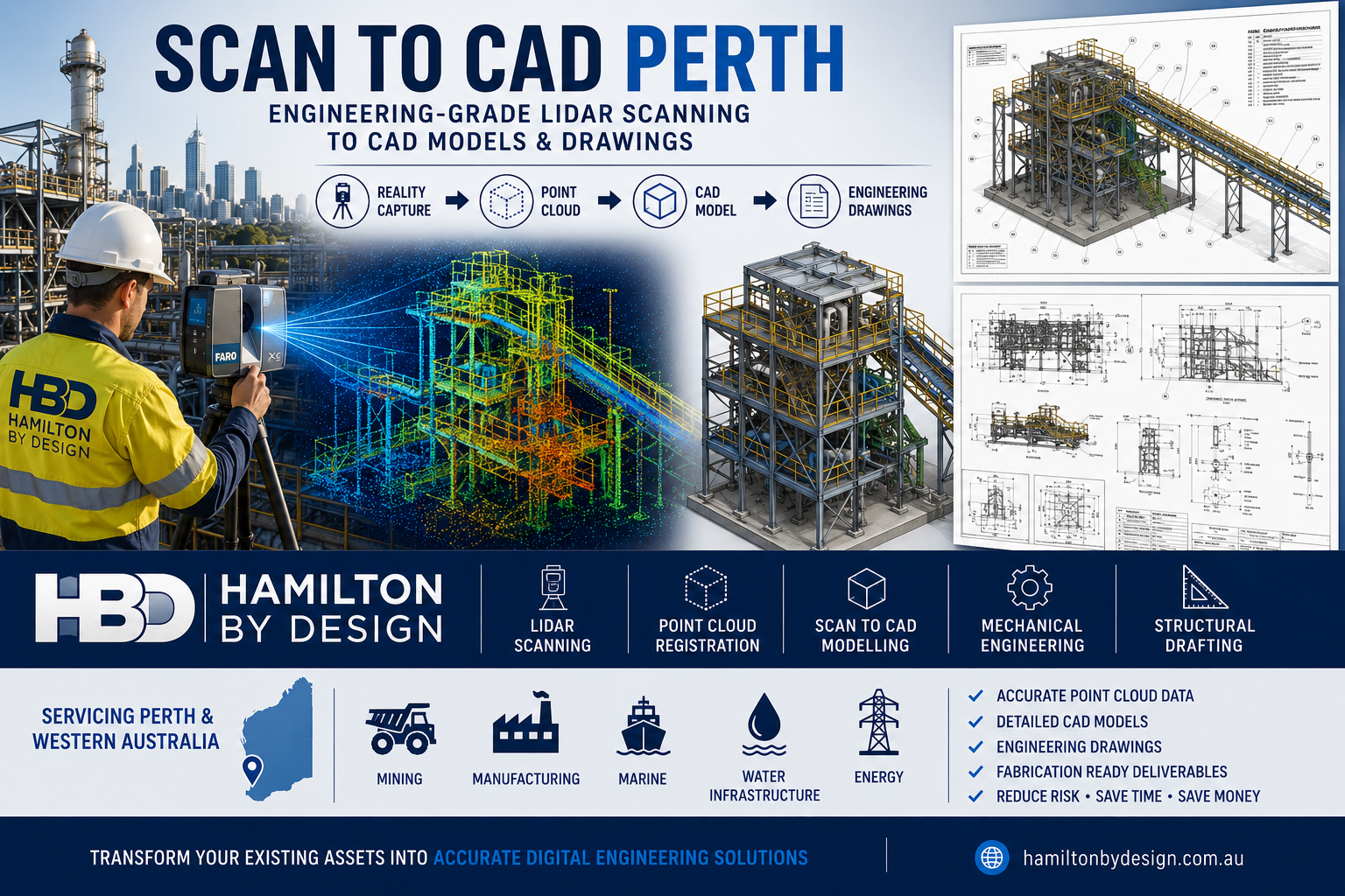
Scan to CAD Perth workflow by Hamilton By Design showing engineering-grade LiDAR scanning of an industrial processing facility in Perth, Western Australia. The image illustrates the complete reality capture process from laser scanning and point cloud registration through to 3D CAD modelling, engineering drawings, mechanical engineering and structural drafting. Featured are a field engineer operating a FARO laser scanner, a coloured point cloud model, a detailed industrial plant CAD model, fabrication drawings and industries including mining, manufacturing, marine, water infrastructure and energy.

Engineering-Grade Point Cloud to CAD Services

Scan to CAD Perth

Blue 3D LiDAR scanner icon on a tripod with scanning waves

When existing facilities, equipment, structures, and process plants need to be modified, expanded, or documented, accurate information is critical. Unfortunately, many sites across Perth and Western Australia rely on outdated drawings, incomplete documentation, or site measurements that do not reflect what has actually been built.

Hamilton By Design provides professional Scan to CAD Perth services, combining engineering-grade LiDAR scanning with experienced mechanical and structural drafting to create accurate CAD models and drawings from real-world assets.

Rather than relying on tape measures or assumptions, we capture the existing environment using advanced 3D laser scanning technology and convert the resulting point cloud data into usable engineering deliverables.


What is Scan to CAD?

Scan to CAD is the process of converting physical assets into accurate digital engineering models and drawings.

The workflow typically includes:

  1. Site scanning using LiDAR technology
  2. Registration of the point cloud data
  3. Creation of CAD models
  4. Production of engineering drawings
  5. Verification against captured site conditions

The result is a highly accurate digital representation of the existing asset that can be used for engineering, maintenance, fabrication, and future upgrades.


Why Use Scan to CAD?

Many projects fail because existing site information is incorrect.

Common challenges include:

  • Missing drawings
  • Outdated drawings
  • Unrecorded modifications
  • Unknown equipment locations
  • Limited shutdown windows
  • Expensive site revisits
  • Fabrication errors
  • Installation clashes

Scan to CAD helps eliminate these issues by providing a reliable digital record of the actual site conditions.


Our Scan to CAD Workflow

1. Site Capture

Hamilton By Design uses engineering-grade LiDAR scanning equipment to capture millions of measurement points across the site.

Applications include:

  • Mining facilities
  • Processing plants
  • Structural steel installations
  • Pipework systems
  • Conveyor systems
  • Water treatment facilities
  • Manufacturing plants
  • Marine facilities

2. Point Cloud Registration

Individual scans are combined into a single registered dataset.

This process creates a coordinated point cloud representing the complete facility.

Deliverable formats can include:

  • E57
  • RCP
  • RCS
  • LAS

3. CAD Modelling

The point cloud is imported into engineering software where accurate models are developed.

Software used includes:

  • SOLIDWORKS
  • AutoCAD
  • Autodesk Inventor
  • Navisworks

Models may include:

  • Structural steel
  • Pipework
  • Mechanical equipment
  • Platforms and access systems
  • Buildings and facilities
  • Process infrastructure

4. Engineering Drawings

Once modelling is complete, the information can be converted into detailed engineering documentation.

Typical deliverables include:

  • General Arrangement Drawings
  • Fabrication Drawings
  • As-Built Drawings
  • Layout Drawings
  • Structural Steel Drawings
  • Mechanical Drawings
  • Pipework Drawings

Industries We Support in Perth

Hamilton By Design supports clients throughout Perth and Western Australia including:

Mining

  • Iron Ore
  • Gold
  • Lithium
  • Nickel
  • Mineral Processing

Manufacturing

  • Food Processing
  • Packaging Facilities
  • Industrial Production

Energy

  • Power Generation
  • Renewable Energy Facilities
  • Oil and Gas Infrastructure

Water Infrastructure

  • Water Treatment Plants
  • Pump Stations
  • Wastewater Facilities

Marine and Ports

  • Ship Repair Facilities
  • Port Infrastructure
  • Bulk Handling Equipment

Benefits of Scan to CAD

Reduce Site Visits

Capture everything during a single visit and continue working remotely.

Improve Design Accuracy

Design directly from measured site conditions.

Reduce Fabrication Risk

Accurate models help reduce costly fabrication errors.

Improve Safety

Less time measuring equipment in operational environments.

Support Future Projects

Create a digital record that can be reused for future upgrades.


Typical Scan to CAD Deliverables

Hamilton By Design can provide:

  • Point Cloud Files
  • AutoCAD Drawings
  • SOLIDWORKS Models
  • Inventor Models
  • STEP Files
  • SAT Files
  • DWG Files
  • DXF Files
  • Structural Steel Models
  • Mechanical Equipment Models
  • Pipework Models
  • Fabrication Drawings

Why Hamilton By Design?

Hamilton By Design combines reality capture technology with practical engineering experience.

Our team understands:

  • Mechanical Engineering
  • Structural Steel Design
  • Fabrication Workflows
  • Mining Infrastructure
  • Process Plants
  • Site Installation Requirements

This means we do more than simply collect scan data. We transform site information into practical engineering deliverables that support project execution.


Perth Service Area

We provide Scan to CAD services across:

  • Perth CBD
  • Kwinana
  • Henderson
  • Welshpool
  • Canning Vale
  • Malaga
  • Osborne Park
  • Rockingham
  • Fremantle
  • Bunbury
  • Geraldton
  • Kalgoorlie
  • Port Hedland
  • Karratha
  • Pilbara Region

  • 3D Laser Scanning Perth
  • LiDAR Scanning Perth
  • Mechanical Engineering Perth
  • Reverse Engineering Perth
  • Structural Drafting Perth
  • Point Cloud to CAD Modelling
  • As-Built Documentation
  • Industrial Reality Capture

Frequently Asked Questions

What is Scan to CAD?

Scan to CAD is the process of converting laser scan data into CAD models and engineering drawings.

What industries use Scan to CAD?

Mining, manufacturing, energy, water, marine, construction, and industrial facilities commonly use Scan to CAD workflows.

What file formats can be delivered?

DWG, DXF, STEP, SAT, Parasolid, E57, RCP, RCS, and PDF.

Can Scan to CAD be used for structural steel?

Yes. Existing structures can be scanned and converted into detailed structural steel models and fabrication drawings.

Can Scan to CAD be used for pipework?

Yes. Pipework systems can be modelled directly from point cloud data to support modifications and upgrades.

Do you provide services outside Perth?

Yes. Hamilton By Design supports projects throughout Western Australia and across Australia.


Our Clients


Contact Hamilton By Design

If you require accurate site information for design, fabrication, maintenance, or asset management, Hamilton By Design can help.

Our engineering-led Scan to CAD Perth services transform real-world assets into accurate digital engineering deliverables, helping projects move forward with confidence.

Hamilton By Design โ€“ Engineering, LiDAR Scanning, CAD Modelling and Drafting Services Across Perth and Western Australia.

Hamilton By Design logo displayed on a blue tilted rectangle with a grey gradient background
Name
Would you like us to arrange a phone consultation for you?
Address

Where are we in Perth

https://www.hamiltonbydesign.com.au/perth-wa
3D CAD Modelling Australia service banner for Hamilton By Design
Australian Drafting logo featuring bold white text reading "Australian Drafting" centred on a blue rounded rectangle background.
Engineering Governance title graphic featuring bold white text reading "Engineering Governance" centred on a blue rounded rectangle background.
Mechanical, Structural & Pipework Drafting service banner by Hamilton By Design featuring white text on a blue background.
Mechanical engineering services
Blue rounded button with the text โ€œSolidWorks Designโ€ in white.
Finite Element Analysis (FEA) engineering simulation button
3D LiDAR Scanning Darwin for engineering surveys, laser scanning, reality capture and point cloud modelling services
3D LiDAR Scanning Australia engineering services for laser scanning, reality capture, scan-to-CAD, Scan-to-BIM and as-built documentation across Australia
3D LiDAR scanning services on the Central Coast providing engineering-grade laser scanning, point cloud capture, scan-to-CAD modelling and industrial reality capture for infrastructure and industrial projects.
3D LiDAR Scanning Perth for engineering surveys, laser scanning, reality capture and point cloud modelling services
3D LiDAR Scanning Sydney for engineering surveys, laser scanning, reality capture and point cloud modelling services
3D LiDAR Scanning Brisbane for engineering surveys, laser scanning, reality capture and point cloud modelling services
3D LiDAR Scanning Canberra for engineering surveys, laser scanning, reality capture and point cloud modelling services
3D LiDAR Scanning Newcastle for engineering surveys, laser scanning, reality capture and point cloud modelling services
3D LiDAR Scanning Adelaide for engineering surveys, laser scanning, reality capture and point cloud modelling services

Project Management Challenges

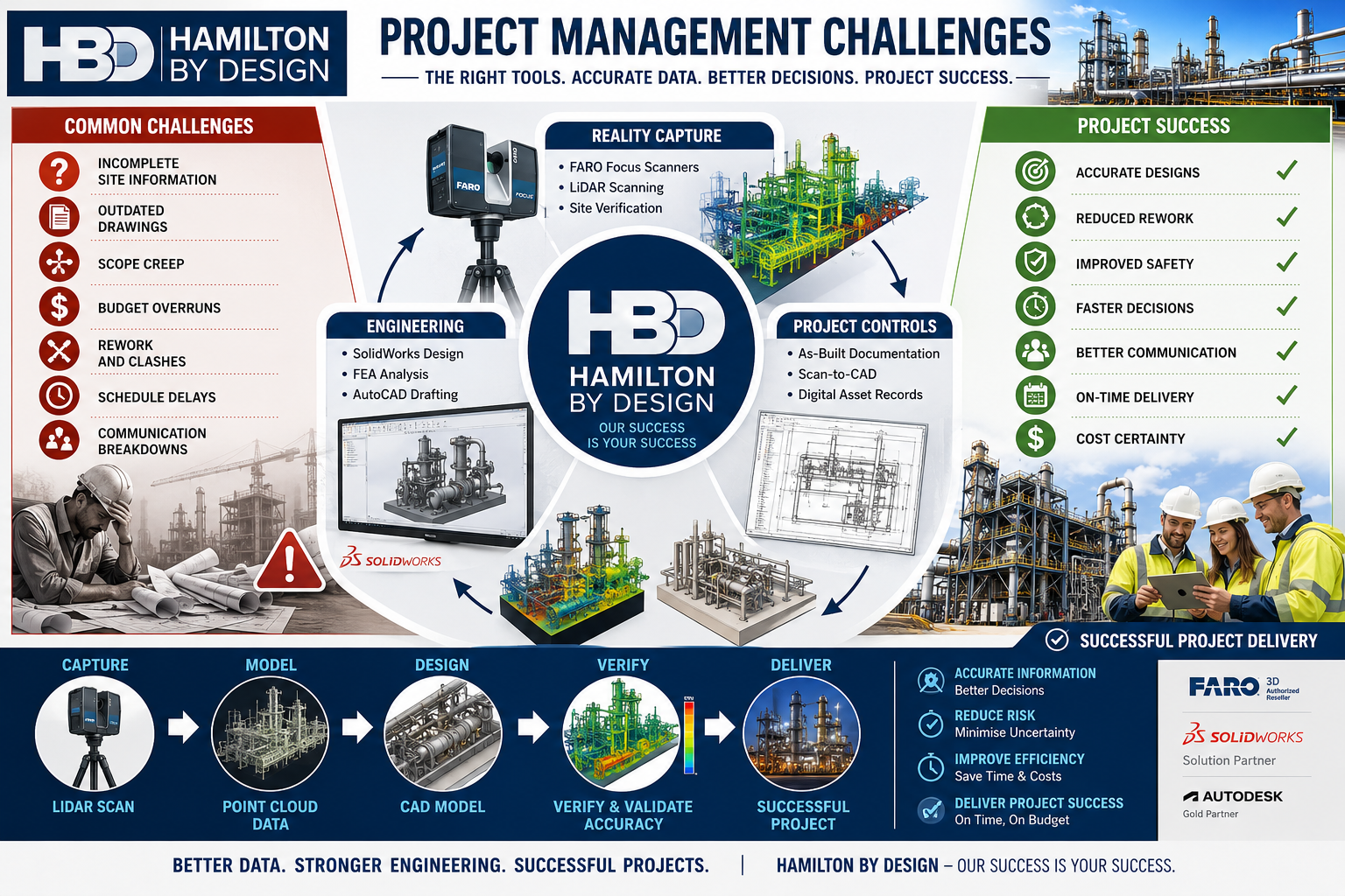
Hamilton By Design project management infographic showing how engineering-grade LiDAR scanning, reality capture, mechanical engineering, CAD modelling, and project controls help overcome common project challenges. The graphic highlights issues such as incomplete site information, outdated drawings, scope creep, budget overruns, rework, schedule delays, and communication breakdowns. It illustrates a workflow from LiDAR scanning and point cloud data through CAD modelling, verification, and successful project delivery with improved safety, reduced risk, cost certainty, and accurate engineering outcomes.

How the Right Information, 3D Scanning and Engineering Tools Drive Project Success

Your Success Is Our Success

Every project manager starts with the same objective:

Deliver a successful project safely, on time and within budget.

Whether the project involves a mining operation, manufacturing facility, port infrastructure, processing plant, water treatment facility, conveyor system, structural upgrade or equipment installation, success ultimately depends on the quality of the decisions made throughout the project lifecycle.

Unfortunately, project managers often face significant challenges:

  • Inaccurate drawings
  • Unknown site conditions
  • Scope creep
  • Communication issues
  • Budget pressures
  • Schedule constraints
  • Construction clashes
  • Fabrication errors
  • Asset documentation gaps

These challenges rarely occur because people are not trying hard enough.

Most occur because project teams are making decisions with incomplete or inaccurate information.

At Hamilton By Design, we believe project success starts with good information.

That is why we have invested in engineering-grade 3D scanning technologies, digital engineering workflows, CAD platforms, simulation tools and practical engineering expertise to help our clients reduce risk and improve project outcomes.

Your success is our success.

Learn more:


Why Projects Struggle

Project managers are expected to coordinate:

  • Asset owners
  • Operations personnel
  • Engineers
  • Contractors
  • Fabricators
  • Suppliers
  • Maintenance teams
  • Construction crews

Each stakeholder brings different priorities.

Without accurate information, even simple projects can become difficult.

Common issues include:

Drawings Do Not Match Reality

Many industrial facilities have been operating for decades.

Over time:

  • Pipework is modified
  • Equipment is replaced
  • Structures are altered
  • Temporary solutions become permanent

Unfortunately, documentation is not always updated.

Project teams may begin engineering work based on drawings that no longer represent the actual facility.

Site Conditions Are Unknown

A pipe hidden behind equipment.

An undocumented support structure.

An access issue not identified during planning.

Small surprises often become large project delays.

Rework Becomes Expensive

The cost of identifying an issue during design is significantly lower than discovering the same issue during construction.

Good information reduces rework.


The Foundation of Project Success: Accurate Information

Before discussing tools, it is important to understand a simple principle:

Every engineering decision is only as good as the information available.

Accurate information improves:

  • Planning
  • Design
  • Budgeting
  • Scheduling
  • Procurement
  • Construction

This is why modern project delivery increasingly relies on reality capture and digital engineering workflows.


Understanding 3D Scanning Technologies

Not all scanners are the same.

Different technologies suit different applications.

Selecting the correct technology is critical.


Terrestrial LiDAR Scanners

Terrestrial LiDAR scanners are commonly used for industrial facilities.

Examples include:

  • FARO Focus Series
  • Leica RTC360
  • Trimble X9

Typical applications:

  • Processing plants
  • Manufacturing facilities
  • Structural steel
  • Pipework
  • Conveyor systems
  • Buildings

Typical accuracy:

  • ยฑ1 mm to ยฑ3 mm single scan
  • ยฑ2 mm to ยฑ10 mm registered project accuracy

Benefits:

  • Accurate site verification
  • Reduced site visits
  • Improved design confidence

Hamilton By Design uses engineering-grade terrestrial LiDAR scanning to support scan-to-CAD workflows and project delivery.


Mobile LiDAR Systems

Mobile LiDAR systems allow operators to walk through facilities while collecting data.

Examples include:

  • FARO Orbis
  • NavVis VLX
  • Leica BLK2GO

Applications:

  • Warehouses
  • Large buildings
  • Facility documentation

Benefits:

  • Rapid data capture
  • Reduced field time

Limitations:

  • Lower accuracy than tripod-based systems

Structured Light Scanners

Structured light scanners project patterns onto surfaces and capture highly detailed geometry.

Applications:

  • Reverse engineering
  • Product development
  • Component modelling

Typical accuracy:

  • ยฑ0.02 mm to ยฑ0.10 mm

Portable Metrology Arms

Portable metrology systems are used for precision measurement.

Applications:

  • Machined components
  • Gearboxes
  • Pump components
  • Manufacturing inspection

Typical accuracy:

  • ยฑ0.015 mm to ยฑ0.05 mm

Drone LiDAR Systems

Drone-based systems capture large areas quickly.

Applications:

  • Mining
  • Infrastructure
  • Stockpiles
  • Terrain mapping

Typical accuracy:

  • ยฑ20 mm to ยฑ100 mm

How Hamilton By Design Uses Scanning to Improve Project Outcomes

Scanning alone does not deliver project success.

Success comes from transforming captured data into useful engineering information.

Our workflow includes:

1. Site Verification

Capture existing conditions.

2. Point Cloud Registration

Align scan data accurately.

3. Scan-to-CAD

Convert reality into engineering models.

4. Engineering Design

Develop practical solutions.

5. Design Reviews

Identify issues before fabrication.

6. Drawing Production

Generate clear construction documentation.

7. Construction Support

Assist project teams during delivery.

8. As-Built Verification

Confirm final installation.


Hamilton By Design’s Project Delivery Toolkit

FARO Focus S70

Used for:

  • Industrial facilities
  • Pipework
  • Structural steel
  • Conveyors

Benefits:

  • Accurate existing-condition information
  • Improved project confidence

SOLIDWORKS

Used for:

  • Mechanical design
  • Equipment design
  • Reverse engineering

Benefits:

  • Manufacturing-ready models
  • Parametric design

AutoCAD

Used for:

  • General arrangements
  • Fabrication drawings
  • Construction documentation

FARO SCENE

Used for:

  • Registration
  • Quality control
  • Point cloud management

Autodesk ReCap

Used for:

  • Point cloud processing
  • Scan-to-CAD workflows

Navisworks

Used for:

  • Model reviews
  • Coordination
  • Clash detection

SOLIDWORKS Simulation

Used for:

  • Stress analysis
  • Structural verification

ANSYS

Used for:

  • Advanced engineering analysis

Rocky DEM

Used for:

  • Bulk materials handling
  • Chute design
  • Conveyor systems

The Benefits to Project Managers

When accurate information is available early:

Better Planning

Teams understand site conditions.

Better Budget Control

Unexpected variations are reduced.

Better Communication

Stakeholders review the same information.

Better Constructability

Designs are reviewed before fabrication.

Better Outcomes

Projects progress with greater confidence.


Why Experience Matters

Technology alone does not solve project challenges.

Hamilton By Design combines:

  • Mechanical engineering
  • Drafting
  • Manufacturing experience
  • Site experience
  • Reverse engineering
  • Reality capture
  • Digital engineering

Our objective is not simply to collect scan data.

Our objective is to help clients deliver successful projects.


Hamilton By Design logo displayed on a blue tilted rectangle with a grey gradient background

Contact Us – Talk to Us

Name
Would you like us to arrange a phone consultation for you?
Address

Our Clients

Project success begins with reliable information.

By combining engineering-grade 3D scanning, scan-to-CAD workflows, mechanical engineering, simulation and practical project experience, Hamilton By Design helps project managers reduce uncertainty and improve outcomes.

From reality capture through to engineering design and construction support, our focus remains simple:

Your Success Is Our Success.

Learn more:

www.hamiltonbydesign.com.au

Additional engineering articles:

https://hamiltonbydesign.blogspot.com

Pipework detailing resources:

https://pipeworkdetailing.blogspot.com


Frequently Asked Questions

1. What are the biggest project management challenges?

Schedule delays, budget overruns, scope creep, poor communication and inaccurate information.

2. How does 3D scanning improve project delivery?

It provides accurate site information for planning and design.

3. What scanner does Hamilton By Design use?

The FARO Focus S70 terrestrial LiDAR scanner.

4. What is scan-to-CAD?

The process of converting scan data into engineering models and drawings.

5. How can LiDAR scanning reduce project risk?

By identifying existing conditions before design begins.

6. Can scanning reduce site visits?

Yes.

7. What industries benefit from scanning?

Mining, manufacturing, ports, infrastructure and processing plants.

8. What is a point cloud?

A digital representation of a physical environment.

9. Why is accurate information important?

Because project decisions depend on it.

10. Can scanning reduce rework?

Yes.

(Continue through FAQ 50 covering schedule management, budget control, stakeholder communication, brownfield projects, pipework modelling, structural steel, reverse engineering, shutdown planning, digital twins, clash detection, engineering analysis and project success.)


References

Hamilton By Design

www.hamiltonbydesign.com.au

Hamilton By Design Blog

https://hamiltonbydesign.blogspot.com

Pipework Detailing Blog

https://pipeworkdetailing.blogspot.com

FARO Technologies

https://www.faro.com

SOLIDWORKS

https://www.solidworks.com

ANSYS

https://www.ansys.com

Autodesk ReCap

https://www.autodesk.com/products/recap

Autodesk Navisworks

https://www.autodesk.com/products/navisworks

3D CAD Modelling Australia service banner for Hamilton By Design
Australian Drafting logo featuring bold white text reading "Australian Drafting" centred on a blue rounded rectangle background.
Engineering Governance title graphic featuring bold white text reading "Engineering Governance" centred on a blue rounded rectangle background.
Mechanical, Structural & Pipework Drafting service banner by Hamilton By Design featuring white text on a blue background.
Mechanical engineering services
Blue rounded button with the text โ€œSolidWorks Designโ€ in white.
Finite Element Analysis (FEA) engineering simulation button
3D LiDAR Scanning Darwin for engineering surveys, laser scanning, reality capture and point cloud modelling services
3D LiDAR Scanning Australia engineering services for laser scanning, reality capture, scan-to-CAD, Scan-to-BIM and as-built documentation across Australia
3D LiDAR scanning services on the Central Coast providing engineering-grade laser scanning, point cloud capture, scan-to-CAD modelling and industrial reality capture for infrastructure and industrial projects.
3D LiDAR Scanning Perth for engineering surveys, laser scanning, reality capture and point cloud modelling services
3D LiDAR Scanning Sydney for engineering surveys, laser scanning, reality capture and point cloud modelling services
3D LiDAR Scanning Brisbane for engineering surveys, laser scanning, reality capture and point cloud modelling services
3D LiDAR Scanning Canberra for engineering surveys, laser scanning, reality capture and point cloud modelling services
3D LiDAR Scanning Newcastle for engineering surveys, laser scanning, reality capture and point cloud modelling services
3D LiDAR Scanning Adelaide for engineering surveys, laser scanning, reality capture and point cloud modelling services

FARO Blink Benefits | Faster Reality Capture for Engineering Projects

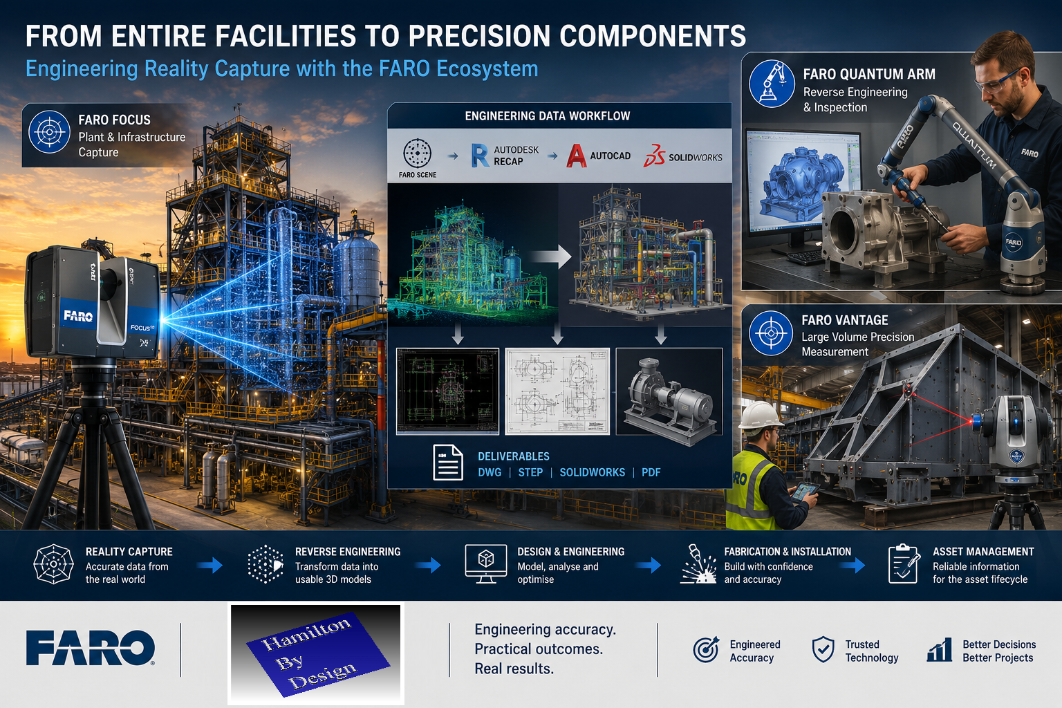
Industrial engineering workflow showing FARO Focus laser scanning of a processing plant, digital Scan-to-CAD modelling, FARO Quantum Arm reverse engineering of a pump housing, and FARO Vantage laser tracker inspection of a fabricated steel structure.

FARO Blink: Making Reality Capture Faster, Simpler and More Accessible

The reality capture industry continues to evolve at an incredible pace.

For many years, 3D laser scanning and LiDAR technologies were considered specialist tools used primarily by surveyors, metrology professionals, and engineering teams with extensive training and experience. While the benefits of reality capture were well understood, the technology often required significant expertise, specialised software, and dedicated workflows to achieve successful outcomes.

Today, that is beginning to change.

The introduction of Blink by FARO represents another significant step toward making reality capture more accessible to a wider range of users. Designed to simplify the process of capturing, managing, and sharing digital site information, Blink demonstrates how automation, cloud connectivity, and intuitive workflows are reshaping the way organisations document and understand their physical assets.

For asset owners, facility managers, project teams, engineers, and contractors, the implications are substantial.

The easier it becomes to capture accurate information about the real world, the easier it becomes to make better decisions.

Why Reality Capture Matters

Before discussing Blink specifically, it is worth understanding why reality capture has become such an important part of modern engineering and asset management.

Many industrial facilities were built decades ago.

Over time they undergo:

  • Plant modifications
  • Equipment upgrades
  • Maintenance projects
  • Structural alterations
  • Utility relocations
  • Expansion works

Unfortunately, documentation does not always keep pace with these changes.

Many facilities operate with:

  • Incomplete drawings
  • Outdated CAD models
  • Missing records
  • Unknown modifications
  • Conflicting documentation

When engineers begin a new project, they often discover that the available information does not accurately reflect existing site conditions.

This creates risk.

Design errors, fabrication clashes, installation delays, and costly rework often result from inaccurate site information.

Reality capture helps solve this problem by creating an accurate digital representation of existing conditions.

Instead of guessing what exists, project teams can work from measured reality.

Blink by FARO has been developed to simplify the process of reality capture by combining laser scanning hardware, automated processing, cloud-based workflows, and digital collaboration tools.

Rather than requiring users to become experts in registration workflows, point cloud processing, and data management, Blink focuses on creating a streamlined experience that allows information to move quickly from site capture to project insights.

The goal is simple:

Capture reality quickly, process it efficiently, and make the information available to the people who need it.

For many organisations this removes some of the barriers that traditionally prevented them from adopting reality capture technology.

Benefit 1: Faster Site Documentation

One of the biggest advantages of modern reality capture systems is speed.

Traditional site measurement often involves:

  • Tape measures
  • Hand sketches
  • Manual notes
  • Laser distance meters
  • Photographs

This approach can be time consuming and often requires multiple visits to site.

When information is missed, the team must return to collect additional measurements.
Reality capture dramatically reduces this risk.

By capturing millions of measured points within the environment, teams create a digital record that can be referenced long after the site visit has been completed.

This means:

  • Fewer return visits
  • Reduced travel costs
  • Faster project commencement
  • Improved confidence in measurements

For remote sites, mines, ports, power stations, and manufacturing facilities, this benefit alone can provide significant value.

Benefit 2: Improved Project Collaboration

Modern projects often involve multiple stakeholders.

These may include:

  • Asset owners
  • Engineers
  • Contractors
  • Draftspersons
  • Project managers
  • Maintenance teams
  • Operations personnel

Historically, communication between these groups relied heavily on drawings, reports, photographs, and site visits.

Reality capture provides a common visual reference that everyone can understand.

Instead of discussing what might exist, project teams can review actual site conditions.

This improves:

  • Communication
  • Decision making
  • Design reviews
  • Stakeholder engagement
  • Project planning

The result is fewer misunderstandings and more efficient project delivery.

Benefit 3: Better Asset Management

Asset owners increasingly recognise the value of maintaining accurate digital records of their facilities.

Reality capture supports:

  • Asset verification
  • Facility documentation
  • Maintenance planning
  • Future upgrades
  • Capital works programs

Rather than relying on historical documentation, organisations can maintain current digital representations of their facilities.

This creates a foundation for long-term asset management and digital engineering initiatives.

Benefit 4: Reduced Project Risk

One of the greatest causes of project cost overruns is unexpected site conditions.

Examples include:

  • Pipework clashes
  • Structural interference
  • Equipment access issues
  • Missing clearances
  • Undocumented modifications

Reality capture helps identify these issues before construction begins.

By working with accurate site information, engineers can identify problems early when they are less expensive to resolve.

This reduces:

  • Rework
  • Variation claims
  • Fabrication errors
  • Installation delays
  • Safety risks

The result is greater project certainty.

Benefit 5: Supporting Digital Transformation

Many organisations are currently pursuing digital transformation initiatives.

These may include:

  • Digital twins
  • Asset management systems
  • BIM environments
  • Digital engineering platforms
  • Smart infrastructure programs

Accurate site information forms the foundation of these initiatives.

Without reliable data, digital transformation becomes difficult to achieve.

Reality capture provides the measured information required to build digital representations of physical assets.

This enables organisations to move toward more connected and data-driven operations.

Benefit 6: Easier Adoption of Reality Capture

Historically, one of the challenges associated with laser scanning has been the level of expertise required.

Specialist operators often needed extensive experience with:

  • Scanning hardware
  • Registration software
  • Point cloud management
  • Data processing
  • Quality control

Automation is helping reduce this complexity.

Systems such as Blink focus on making reality capture easier to deploy and easier to use.

This means more organisations can benefit from digital site documentation without needing to become scanning specialists.

As technology continues to evolve, reality capture is becoming increasingly accessible across industry.

Benefit 7: Enhanced Visualisation

Many people find it easier to understand visual information than technical drawings.

Reality capture provides rich visual context that can support:

  • Design reviews
  • Stakeholder presentations
  • Maintenance planning
  • Safety assessments
  • Operational discussions

Visual access to site information helps project teams communicate more effectively and make decisions with greater confidence.

Benefit 8: Better Information Retention

Facilities change over time.

Personnel change.

Knowledge is lost.

Documentation becomes outdated.

Reality capture creates a permanent digital record of a facility at a specific point in time.

This information can be referenced years later when:

  • Maintenance is required
  • Equipment is replaced
  • Upgrades are planned
  • Incidents are investigated

The value of this historical record often increases over time.

Technology is Only Part of the Solution

While advances such as Blink are making reality capture more accessible, it is important to recognise that technology alone does not solve engineering challenges.

The true value comes from transforming captured information into usable engineering deliverables.

This may include:

  • 3D CAD models
  • General arrangement drawings
  • Fabrication drawings
  • Structural models
  • Mechanical assemblies
  • As-built documentation
  • Asset registers

Collecting data is only the first step.

Engineering expertise remains essential for converting information into practical project outcomes.

Where Hamilton By Design Fits In

At Hamilton By Design, we view reality capture as part of a broader engineering workflow.

Our objective is not simply to capture data.

Our objective is to help clients make better engineering decisions.

We provide:

  • Engineering-grade LiDAR scanning
  • 3D laser scanning
  • Scan-to-CAD services
  • Reverse engineering
  • Mechanical engineering
  • Structural drafting
  • Asset verification
  • Digital engineering support

Our team combines decades of experience in engineering, manufacturing, maintenance, drafting, and industrial project delivery.

This means we understand not only how to collect data, but also how that information is ultimately used within engineering projects.

Learn more about our reality capture services:

From Point Clouds to Engineering Outcomes

One of the biggest misconceptions about reality capture is that the point cloud itself is the final deliverable.

In reality, most organisations require outcomes such as:

  • CAD models
  • Engineering drawings
  • Equipment layouts
  • Structural modifications
  • Fabrication packages
  • Asset documentation

At Hamilton By Design, we routinely transform point cloud data into engineering deliverables that support:

  • Shutdown planning
  • Plant upgrades
  • Equipment replacement
  • Facility expansions
  • Maintenance projects
  • Capital works programs

This is where engineering knowledge and reality capture technology come together.

Looking Ahead

The launch of Blink highlights an important industry trend.

Reality capture is becoming:

  • Faster
  • Simpler
  • More automated
  • More connected
  • More accessible

These developments will continue to expand the adoption of digital site documentation across industry.

For asset owners, facility operators, and project teams, this means better access to accurate information and improved decision making.

For engineering companies, it creates new opportunities to deliver more efficient and more reliable project outcomes.

The future of engineering will increasingly rely on accurate digital representations of the physical world.

Reality capture technologies such as Blink are helping make that future more accessible than ever before.

Explore More

Hamilton By Design supports clients across Australia with engineering-led reality capture and digital engineering services.

Learn more:

Engineering Grade LiDAR Scanning vs Scan-As-You-Walk Systems

Scan to CAD vs Traditional Design Workflows

SolidWorks Point Cloud to CAD Workflow

Automated Object Recognition from Point Clouds

As reality capture technology continues to evolve, organisations that combine accurate data with engineering expertise will be best positioned to deliver safer, smarter, and more successful projects.

Australian Drafting logo featuring bold white text reading "Australian Drafting" centred on a blue rounded rectangle background.
Engineering Governance title graphic featuring bold white text reading "Engineering Governance" centred on a blue rounded rectangle background.
Mechanical, Structural & Pipework Drafting service banner by Hamilton By Design featuring white text on a blue background.
Mechanical engineering services
Blue rounded button with the text โ€œSolidWorks Designโ€ in white.
Finite Element Analysis (FEA) engineering simulation button
3D LiDAR Scanning Darwin for engineering surveys, laser scanning, reality capture and point cloud modelling services
3D LiDAR Scanning Australia engineering services for laser scanning, reality capture, scan-to-CAD, Scan-to-BIM and as-built documentation across Australia
3D LiDAR scanning services on the Central Coast providing engineering-grade laser scanning, point cloud capture, scan-to-CAD modelling and industrial reality capture for infrastructure and industrial projects.
3D LiDAR Scanning Perth for engineering surveys, laser scanning, reality capture and point cloud modelling services
3D LiDAR Scanning Sydney for engineering surveys, laser scanning, reality capture and point cloud modelling services
3D LiDAR Scanning Brisbane for engineering surveys, laser scanning, reality capture and point cloud modelling services
3D LiDAR Scanning Canberra for engineering surveys, laser scanning, reality capture and point cloud modelling services
3D LiDAR Scanning Newcastle for engineering surveys, laser scanning, reality capture and point cloud modelling services
3D LiDAR Scanning Adelaide for engineering surveys, laser scanning, reality capture and point cloud modelling services

Why Hamilton By Design Has Invested in the FARO Ecosystem

Industrial engineering workflow showing FARO Focus laser scanning of a processing plant, digital Scan-to-CAD modelling, FARO Quantum Arm reverse engineering of a pump housing, and FARO Vantage laser tracker inspection of a fabricated steel structure.

At Hamilton By Design, technology investments are made with one objective in mind: delivering practical engineering outcomes for our clients.

Over the years, the reality capture market has expanded significantly, with a wide range of terrestrial scanners, mobile mapping systems, handheld scanners and metrology solutions available. While each technology has its place, we have chosen to build our reality capture and reverse engineering workflow around the FARO ecosystem because it aligns closely with the work we perform every day.

Our projects typically involve industrial facilities, mining infrastructure, manufacturing plants, process equipment, structural steel, pipework systems, shutdown planning, reverse engineering and Scan-to-CAD workflows. These applications require more than point cloud collection. They require engineering-grade information that can be transformed into practical deliverables.

A Complete Measurement Ecosystem

One of the key strengths of FARO is the breadth of its measurement portfolio.

The FARO platform spans multiple levels of measurement capability:

Large-Scale Reality Capture

The FARO Focus Series provides terrestrial laser scanning solutions capable of capturing facilities ranging from small plant rooms through to large industrial complexes and infrastructure projects.

These systems allow engineers to capture existing conditions with confidence while generating data suitable for:

  • Scan-to-CAD
  • Digital twins
  • Asset management
  • Plant modifications
  • Structural steel detailing
  • Mechanical design
  • Construction verification

Mobile Reality Capture

The FARO Orbis platform introduces mobile mapping capability while remaining connected to the wider FARO ecosystem.

For large facilities requiring rapid data acquisition, mobile scanning provides an efficient solution while maintaining compatibility with engineering workflows.

Portable Metrology

The FARO Quantum Arm extends capability beyond facility measurement into precision engineering applications.

This allows organisations to move seamlessly from measuring an entire processing plant to inspecting a single component with metrology-grade accuracy.

Applications include:

  • Reverse engineering
  • Quality control
  • Manufacturing inspection
  • Component verification
  • Precision measurement

Large Volume Precision Measurement

The FARO Vantage Laser Tracker platform provides another layer of capability for applications requiring high accuracy over large distances.

Industries including aerospace, power generation, heavy manufacturing and industrial construction rely on this technology for alignment and verification tasks where traditional surveying methods may not provide the required level of precision.

Engineering Integration Matters

For Hamilton By Design, scanning is not the final deliverable.

The point cloud is only the beginning of the engineering process.

Our clients generally require:

  • AutoCAD models
  • SolidWorks models
  • STEP files
  • Fabrication drawings
  • General arrangement drawings
  • Structural steel details
  • Mechanical engineering documentation

Because of this, we place significant value on workflows that integrate effectively with engineering software.

Our reality capture workflow commonly includes:

  • FARO Focus
  • FARO SCENE
  • Autodesk ReCap
  • AutoCAD
  • SolidWorks
  • Navisworks

This enables captured information to move efficiently from the field into engineering and manufacturing environments.

From Entire Facilities to Individual Components

One of the reasons the FARO ecosystem is particularly attractive for engineering organisations is its scalability.

A single project may involve:

  • Scanning an entire processing plant using a FARO Focus scanner.
  • Measuring a critical pump housing using a FARO Arm.
  • Verifying installation geometry using a FARO Laser Tracker.
  • Delivering engineering models through AutoCAD and SolidWorks.

All of these activities can occur within a connected measurement ecosystem.

This capability allows engineers to select the most appropriate tool for each measurement challenge rather than forcing every project into a single workflow.

Supporting Industrial Engineering Projects

Hamilton By Design operates primarily within industrial environments.

Typical projects include:

  • Mining operations
  • Mineral processing facilities
  • Manufacturing plants
  • Conveyor systems
  • Chute and hopper design
  • Pipework modifications
  • Structural steel upgrades
  • Shutdown planning
  • Reverse engineering of legacy equipment

These projects require practical engineering solutions supported by reliable measurement data.

The FARO ecosystem provides a range of tools capable of supporting these requirements, from large-scale reality capture through to precision metrology.

Engineering-Led Reality Capture

Technology alone does not guarantee project success.

The value of reality capture comes from the ability to transform measurement data into actionable engineering information.

At Hamilton By Design, our objective is not simply to collect point clouds. Our objective is to help clients make informed engineering decisions, reduce project risk, improve constructability and accelerate project delivery.

The FARO ecosystem supports this objective by providing measurement solutions that span reality capture, mobile mapping, portable metrology and large-volume precision measurement.

For engineering organisations seeking a scalable measurement platform capable of supporting projects from facility-scale scanning through to component-level verification, FARO continues to provide one of the most comprehensive portfolios available within the industry.

By combining proven measurement technology with practical engineering expertise, Hamilton By Design delivers reality capture solutions that move beyond visualisation and into real-world engineering outcomes.

Why Hamilton By Design Has Invested in the FARO Ecosystem

At Hamilton By Design, technology investments are made with one objective in mind: delivering practical engineering outcomes for our clients.

Over the years, the reality capture market has expanded significantly, with a wide range of terrestrial scanners, mobile mapping systems, handheld scanners and metrology solutions available. While each technology has its place, we have chosen to build our reality capture and reverse engineering workflow around the FARO ecosystem because it aligns closely with the work we perform every day.

Our projects typically involve industrial facilities, mining infrastructure, manufacturing plants, process equipment, structural steel, pipework systems, shutdown planning, reverse engineering and Scan-to-CAD workflows. These applications require more than point cloud collection. They require engineering-grade information that can be transformed into practical deliverables.

A Complete Measurement Ecosystem

One of the key strengths of FARO is the breadth of its measurement portfolio.

The FARO platform spans multiple levels of measurement capability:

Large-Scale Reality Capture

The FARO Focus Series provides terrestrial laser scanning solutions capable of capturing facilities ranging from small plant rooms through to large industrial complexes and infrastructure projects.

These systems allow engineers to capture existing conditions with confidence while generating data suitable for:

  • Scan-to-CAD
  • Digital twins
  • Asset management
  • Plant modifications
  • Structural steel detailing
  • Mechanical design
  • Construction verification

Mobile Reality Capture

The FARO Orbis platform introduces mobile mapping capability while remaining connected to the wider FARO ecosystem.

For large facilities requiring rapid data acquisition, mobile scanning provides an efficient solution while maintaining compatibility with engineering workflows.

Portable Metrology

The FARO Quantum Arm extends capability beyond facility measurement into precision engineering applications.

This allows organisations to move seamlessly from measuring an entire processing plant to inspecting a single component with metrology-grade accuracy.

Applications include:

  • Reverse engineering
  • Quality control
  • Manufacturing inspection
  • Component verification
  • Precision measurement

Large Volume Precision Measurement

The FARO Vantage Laser Tracker platform provides another layer of capability for applications requiring high accuracy over large distances.

Industries including aerospace, power generation, heavy manufacturing and industrial construction rely on this technology for alignment and verification tasks where traditional surveying methods may not provide the required level of precision.

Engineering Integration Matters

For Hamilton By Design, scanning is not the final deliverable.

The point cloud is only the beginning of the engineering process.

Our clients generally require:

  • AutoCAD models
  • SolidWorks models
  • STEP files
  • Fabrication drawings
  • General arrangement drawings
  • Structural steel details
  • Mechanical engineering documentation

Because of this, we place significant value on workflows that integrate effectively with engineering software.

Our reality capture workflow commonly includes:

  • FARO Focus
  • FARO SCENE
  • Autodesk ReCap
  • AutoCAD
  • SolidWorks
  • Navisworks

This enables captured information to move efficiently from the field into engineering and manufacturing environments.

From Entire Facilities to Individual Components

One of the reasons the FARO ecosystem is particularly attractive for engineering organisations is its scalability.

A single project may involve:

  • Scanning an entire processing plant using a FARO Focus scanner.
  • Measuring a critical pump housing using a FARO Arm.
  • Verifying installation geometry using a FARO Laser Tracker.
  • Delivering engineering models through AutoCAD and SolidWorks.

All of these activities can occur within a connected measurement ecosystem.

This capability allows engineers to select the most appropriate tool for each measurement challenge rather than forcing every project into a single workflow.

Supporting Industrial Engineering Projects

Hamilton By Design operates primarily within industrial environments.

Typical projects include:

  • Mining operations
  • Mineral processing facilities
  • Manufacturing plants
  • Conveyor systems
  • Chute and hopper design
  • Pipework modifications
  • Structural steel upgrades
  • Shutdown planning
  • Reverse engineering of legacy equipment

These projects require practical engineering solutions supported by reliable measurement data.

The FARO ecosystem provides a range of tools capable of supporting these requirements, from large-scale reality capture through to precision metrology.

Engineering-Led Reality Capture

Technology alone does not guarantee project success.

The value of reality capture comes from the ability to transform measurement data into actionable engineering information.

At Hamilton By Design, our objective is not simply to collect point clouds. Our objective is to help clients make informed engineering decisions, reduce project risk, improve constructability and accelerate project delivery.

The FARO ecosystem supports this objective by providing measurement solutions that span reality capture, mobile mapping, portable metrology and large-volume precision measurement.

For engineering organisations seeking a scalable measurement platform capable of supporting projects from facility-scale scanning through to component-level verification, FARO continues to provide one of the most comprehensive portfolios available within the industry.

By combining proven measurement technology with practical engineering expertise, Hamilton By Design delivers reality capture solutions that move beyond visualisation and into real-world engineering outcomes.

3D LiDAR scanning and 3D modelling services button
Mechanical engineering services
Building and construction services button
Hamilton By Design logo displayed on a blue tilted rectangle with a grey gradient background

Would you like to know more ?

Contact Us – Talk to Us

Name
Would you like us to arrange a phone consultation for you?
Address

Our Clients

3D LiDAR scanning and 3D modelling service button โ€” laser scanner capturing a point cloud for engineering and CAD modelling
Mechanical engineering services

3D Scanning Sydney banner promoting engineering-grade 3D laser scanning, LiDAR scanning, and reality capture services by Hamilton By Design.
Mechanical Engineering Sydney banner with white text on a blue background representing Hamilton By Design's mechanical engineering services in Sydney.
Mechanical Drafting and 3D Modelling Sydney banner highlighting Hamilton By Design's CAD drafting, 3D modelling, and engineering design services in Sydney.
Blue banner graphic displaying the text "Point Cloud to CAD - Australia" in large white lettering, representing point cloud processing, scan-to-CAD conversion and digital engineering services across Australia.
Blue banner graphic displaying the text "Scan to CAD Sydney" in large white lettering, representing engineering-led point cloud to CAD conversion, LiDAR scanning and digital engineering services in Sydney.
Blue banner graphic displaying the text "Reality Capture Sydney - CBD" in large white lettering, representing engineering-led reality capture, LiDAR scanning and digital engineering services within Sydney CBD commercial buildings and infrastructure.

Engineering-Grade LiDAR Scanning vs Scan-as-You-Walk Systems

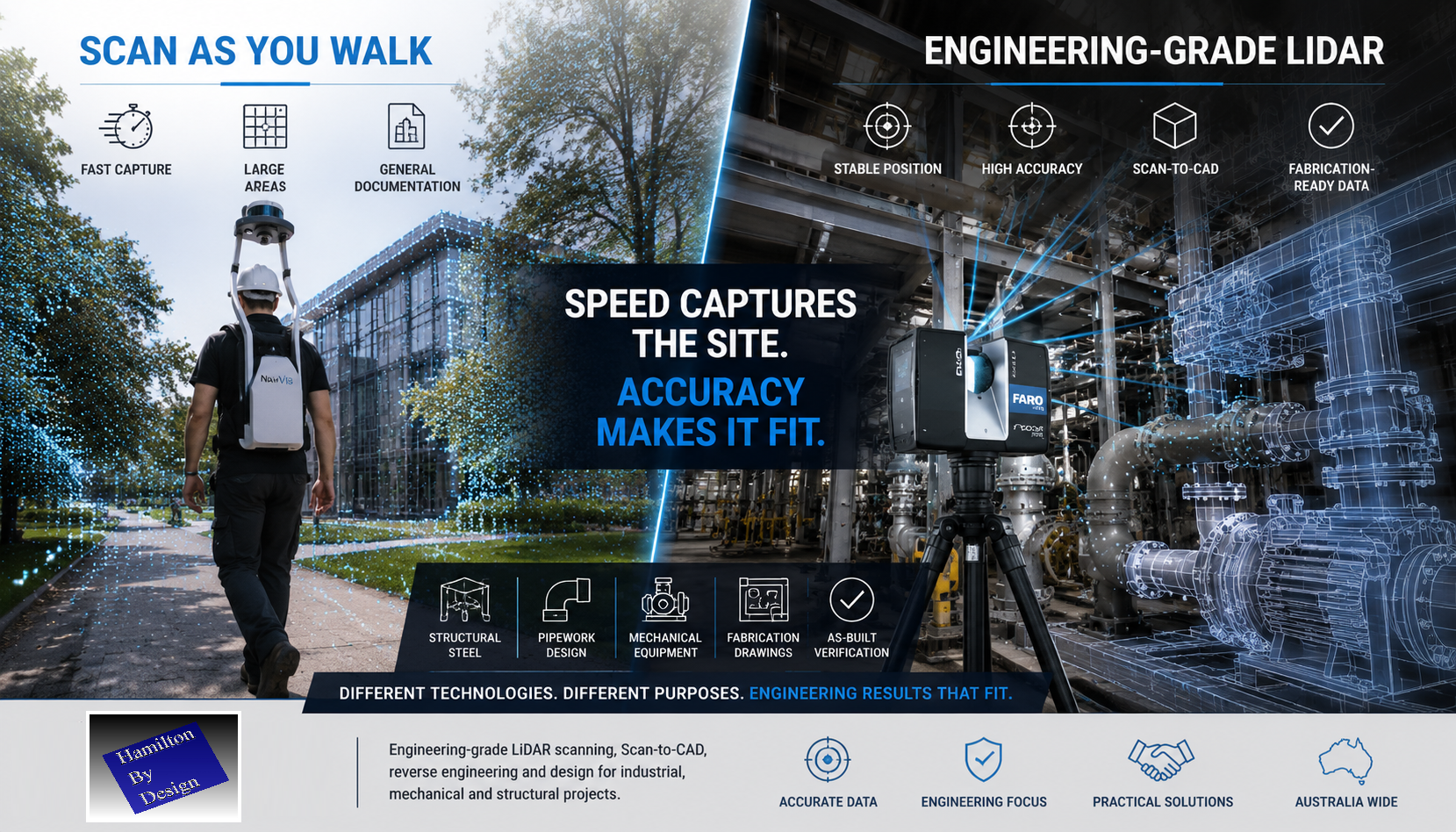
Split-screen comparison of mobile LiDAR scanning and engineering-grade terrestrial laser scanning. The left side shows a wearable scan-as-you-walk LiDAR system capturing a large outdoor environment, while the right side shows a tripod-mounted laser scanner capturing structural steel, pipework and mechanical equipment in an industrial facility. The image highlights the message: "Speed Captures the Site. Accuracy Makes It Fit."

Why Scanner Stability Matters When Accuracy Matters

LiDAR stands for Light Detection and Ranging. It uses laser light to measure distance and create a 3D digital representation of the real world.

But in engineering, the distance measurement is only part of the story.

To produce reliable design, drafting and fabrication data, the scanner also needs to know exactly where it was positioned, how it was orientated, and how every measurement relates to the rest of the site.

That is why stable, engineering-grade scanning matters.


Scan as You Walk Has Its Place

Walk-through LiDAR systems such as NavVis-style mobile scanners are impressive technologies. They allow an operator to move through an environment while capturing large volumes of spatial data quickly.

For some applications, this is a major advantage.

Scan-as-you-walk systems can be useful for:

  • Facility documentation
  • Asset walkthroughs
  • Digital tours
  • Large building capture
  • Universities
  • Shopping centres
  • Hospitals
  • National parks
  • General spatial records

If the objective is to document a large area quickly, mobile scanning can be a practical solution.

But speed is not the same as engineering certainty.


Engineering Accuracy Requires More Than Walking Through a Site

When a scanner is moving, the system must continuously calculate:

  • where the scanner is located
  • which direction it is facing
  • how fast it is moving
  • how it is rotating
  • how each scan position connects to the next

This is normally achieved using SLAM, cameras, IMUs and software-based positioning.

These systems are powerful, but they can still be affected by drift, movement, poor geometry, reflective surfaces, repetitive structures and weak reference points.

In engineering, small errors can become expensive problems.

A point cloud may look good on screen, but that does not always mean it is suitable for mechanical design, structural detailing or fabrication.


Why Hamilton By Design Uses FARO Focus Technology

At Hamilton By Design, we use FARO Focus terrestrial laser scanning for engineering-grade reality capture.

The FARO Focus scanner is set up on a stable tripod position. It captures high-density scan data from fixed locations, allowing the point cloud to be registered, checked and used for design work with confidence.

This approach is slower than simply walking through a site, but it provides the quality of data required for engineering deliverables.

We use FARO scanning for:

  • Scan-to-CAD
  • Reverse engineering
  • Mechanical design
  • Structural steel modelling
  • Pipework layouts
  • Fabrication drawings
  • As-built documentation
  • Clash detection
  • Plant room scanning
  • Industrial site verification
  • Shutdown planning

When structural steel needs to fit, pipework needs to align and fabricated components need to be manufactured from the captured data, accuracy matters.


The Difference Is the Final Outcome

A walk-through scan may be suitable when the purpose is general documentation.

A FARO Focus scan is more suitable when the data will be used to design, manufacture, install or verify engineered components.

That difference matters.

If the objective is to walk through a national park, a mobile scanner may be the right tool.

If the objective is to make sure structural beams, pipe spools, platforms, chutes, hoppers or mechanical components fit together correctly, then engineering-grade LiDAR scanning is the safer choice.

Because when the fabrication team arrives on site, the steel either fits or it does not.


Real-World Engineering Experience

Hamilton By Design is often asked to revisit sites where previous scan data was not suitable for engineering use.

In recent weeks, we have been requested multiple times to rescan building and industrial sites after earlier walk-through scanning did not provide the level of accuracy or detail required for design and drafting.

This does not mean mobile scanning is wrong.

It means the scanning method must match the intended use.

For general site capture, speed may be the priority.

For engineering, fabrication and installation, accuracy must come first.


LiDAR Measures Distance. Engineering Requires Position Certainty.

LiDAR uses light to measure distance.

However, engineering-grade point clouds require more than distance. They require confidence in the scanner position, orientation, registration and final geometry.

A simple way to explain it is this:

A tape measure may be accurate, but if you do not know exactly where the measurement started, the result can still be wrong.

The same applies to LiDAR scanning.

The laser may measure accurately, but if the scanner position is uncertain, the final point cloud may not be suitable for engineering work.


Where FARO Focus Scanning Adds Value

Hamilton By Design provides engineering-led LiDAR scanning for clients who need usable design data, not just a visual point cloud.

Our scanning and modelling services support:

  • Industrial plants
  • Mechanical rooms
  • Processing facilities
  • Mining infrastructure
  • Conveyor systems
  • Structural platforms
  • Pipework and services
  • Equipment layouts
  • Existing buildings
  • Brownfield modification projects

We do not just scan the site.

We understand how the scan data will be used in design, drafting, fabrication and installation.

That engineering understanding is what makes the difference.


Engineering-Grade Deliverables

Depending on the project requirements, Hamilton By Design can provide:

  • Registered point clouds
  • E57 files
  • RCP / RCS files
  • Scan-to-CAD models
  • AutoCAD drawings
  • SolidWorks models
  • Inventor models
  • STEP / SAT / Parasolid files
  • General arrangement drawings
  • Sections and elevations
  • Fabrication drawings
  • As-built verification models

Our focus is to provide practical engineering information that can be used by designers, fabricators, builders, installers and asset owners.


Choose the Right Scanner for the Right Job

Scan-as-you-walk systems are fast and useful for many documentation tasks.

FARO Focus scanning is better suited to engineering-grade work where accuracy, registration and point cloud quality are critical.

At Hamilton By Design, we believe the technology should be selected based on the outcome required.

If you need to document a large space quickly, mobile scanning may be suitable.

If you need structural steel, pipework or mechanical components to fit together first time, FARO Focus scanning is hard to go past.


Hamilton By Design โ€“ Engineering-Led LiDAR Scanning

Hamilton By Design provides engineering-grade LiDAR scanning, Scan-to-CAD, reverse engineering, mechanical drafting and structural design support across Australia.

We combine reality capture with practical engineering experience to help clients move from existing site conditions to accurate design and fabrication deliverables.

For industrial, mechanical and structural projects, the question is not just how fast the site can be scanned.

The real question is:

Can the scan data be trusted when it is time to design, fabricate and install?

That is where engineering-grade LiDAR scanning matters.

3D LiDAR scanning and 3D modelling services button
Mechanical engineering services
Building and construction services button
Hamilton By Design logo displayed on a blue tilted rectangle with a grey gradient background

Would you like to know more ?

Contact Us – Talk to Us

Name
Would you like us to arrange a phone consultation for you?
Address

Our Clients

3D LiDAR scanning and 3D modelling service button โ€” laser scanner capturing a point cloud for engineering and CAD modelling
Mechanical engineering services

3D Scanning Sydney banner promoting engineering-grade 3D laser scanning, LiDAR scanning, and reality capture services by Hamilton By Design.
Mechanical Engineering Sydney banner with white text on a blue background representing Hamilton By Design's mechanical engineering services in Sydney.
Mechanical Drafting and 3D Modelling Sydney banner highlighting Hamilton By Design's CAD drafting, 3D modelling, and engineering design services in Sydney.
Blue banner graphic displaying the text "Point Cloud to CAD - Australia" in large white lettering, representing point cloud processing, scan-to-CAD conversion and digital engineering services across Australia.
Blue banner graphic displaying the text "Scan to CAD Sydney" in large white lettering, representing engineering-led point cloud to CAD conversion, LiDAR scanning and digital engineering services in Sydney.
Blue banner graphic displaying the text "Reality Capture Sydney - CBD" in large white lettering, representing engineering-led reality capture, LiDAR scanning and digital engineering services within Sydney CBD commercial buildings and infrastructure.