Creating a Digital Source of Truth: Improving Asset Management Through Digital Engineering

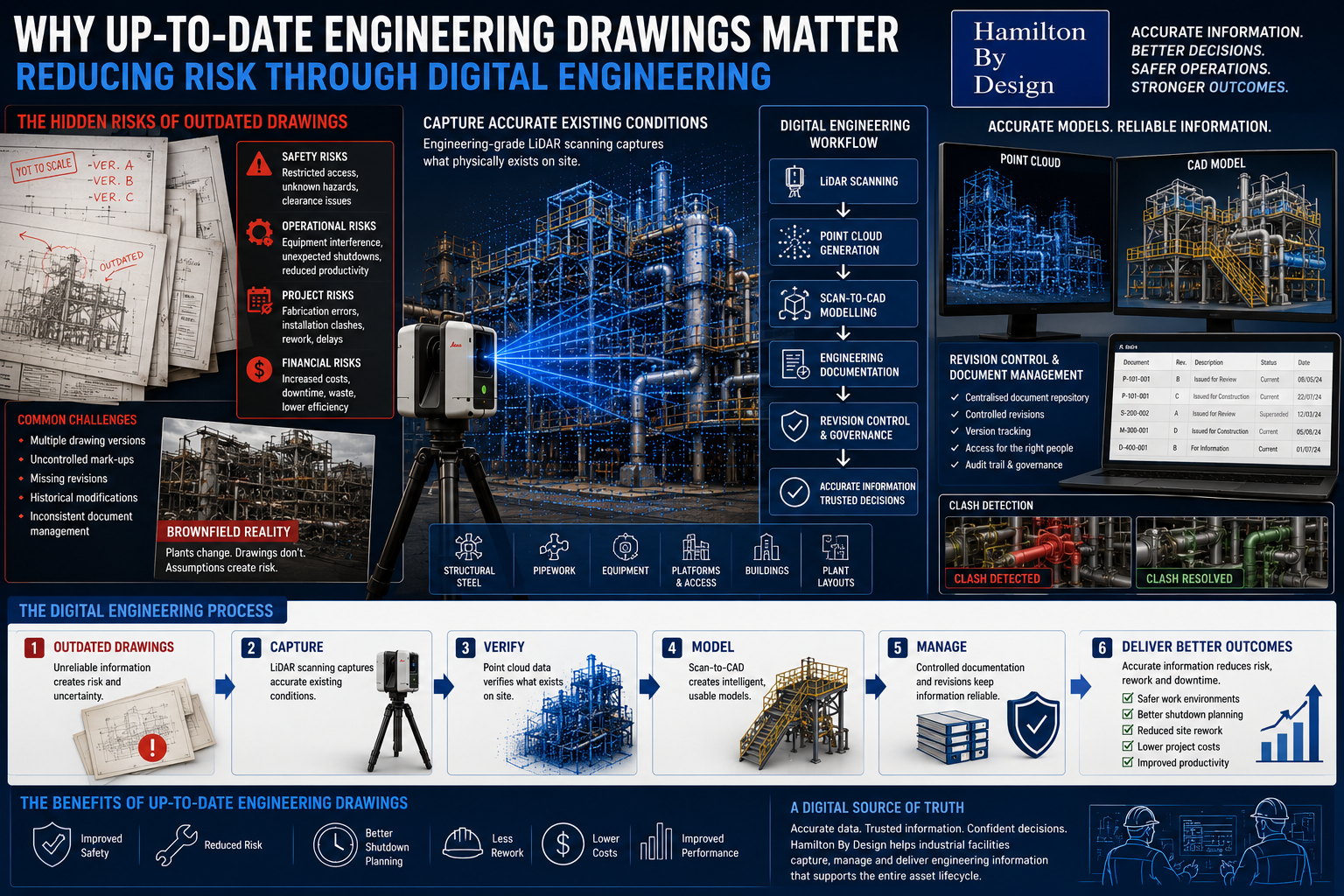
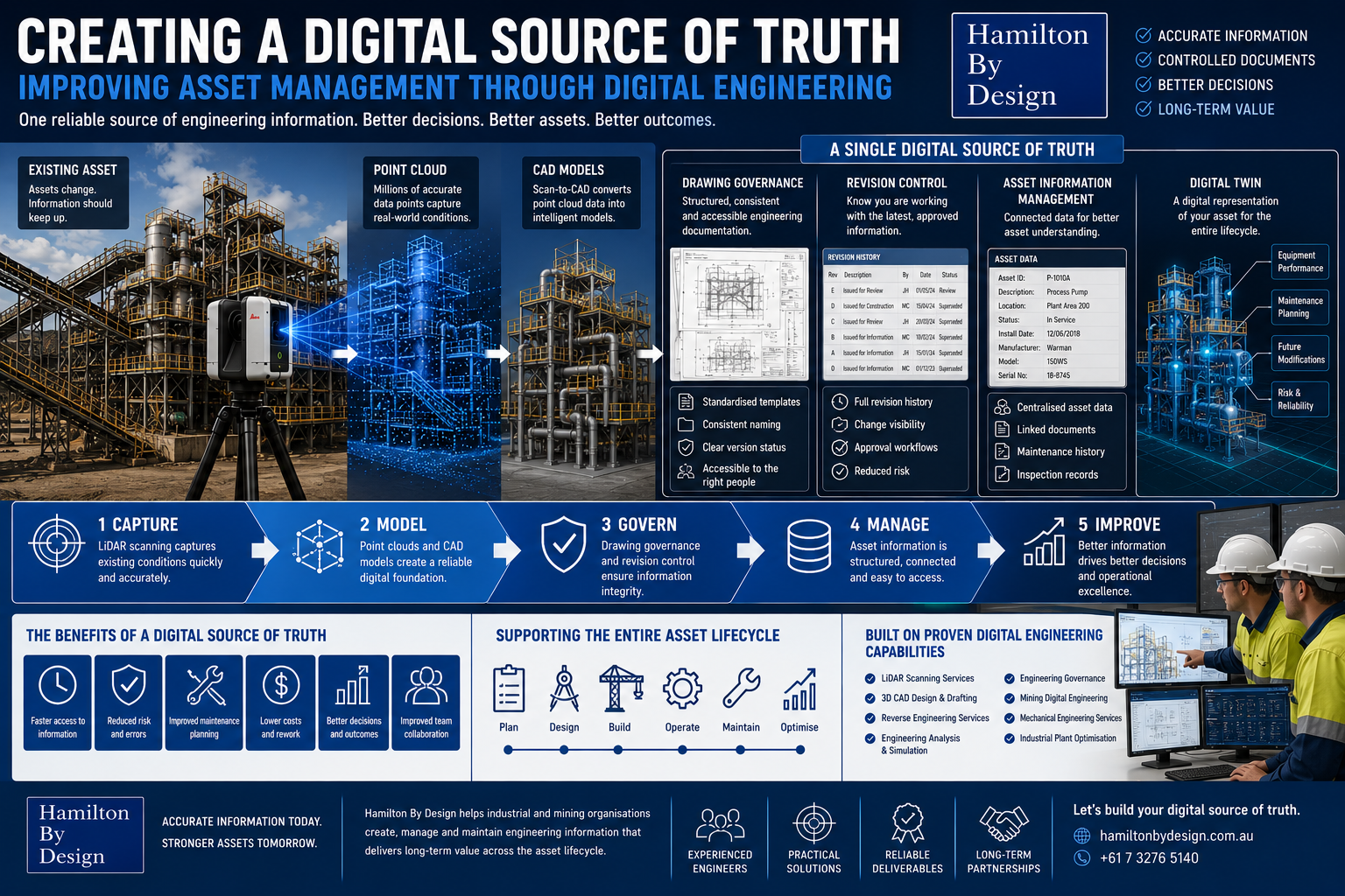
Engineering-grade LiDAR scanning and digital engineering workflow showing how a digital source of truth improves long-term asset management.

Industrial assets change over time. Equipment is upgraded, drawings are revised, platforms are modified, components are replaced, and maintenance activities gradually reshape the plant.

When engineering information is spread across old drawings, uncontrolled PDFs, manual mark-ups, spreadsheets, and individual folders, asset management becomes harder than it needs to be.

A digital source of truth helps bring engineering information together so teams can make decisions using reliable, current, and controlled data.

At Hamilton By Design, we support digital engineering asset management by combining LiDAR scanning, CAD modelling, drawing governance, revision control, and digital engineering workflows.

What is a Digital Source of Truth?

A digital source of truth is a controlled location where accurate engineering information can be stored, managed, accessed, and updated.

It may include:

  • Engineering drawings
  • CAD models
  • Point cloud data
  • Asset information
  • Revision history
  • Inspection records
  • Fabrication documentation
  • Engineering reports

The goal is simple:

One reliable place for engineering information.

Why Asset Information Management Matters

Poorly controlled information can create:

  • Outdated drawings
  • Duplicate files
  • Missing revisions
  • Conflicting information
  • Fabrication errors
  • Shutdown delays
  • Maintenance confusion

Good asset information management improves:

  • Decision making
  • Project planning
  • Maintenance efficiency
  • Drawing control
  • Long-term asset performance

Digital Engineering Workflows

Hamilton By Design can support workflows such as:

  • Engineering-grade LiDAR scanning
  • Existing condition capture
  • Point cloud generation
  • Scan-to-CAD conversion
  • CAD modelling
  • Engineering drawings
  • Revision-controlled documentation
  • Digital asset records

This turns real-world site information into usable engineering data.

Drawing Governance and Revision Control

Drawing governance helps ensure the right people are using the right information.

This includes:

  • Controlled drawing revisions
  • Clear document naming
  • Updated engineering records
  • Managed mark-ups
  • Approval workflows
  • Accessible project information
3D CAD Modelling Australia service banner for Hamilton By Design

Without revision control, teams may unknowingly use superseded drawings.

Digital Twins and Long-Term Asset Management

A digital twin does not need to start as a complex system. For many industrial sites, it begins with accurate geometry, controlled drawings, and reliable asset records.

Digital engineering can support:

  • Plant upgrades
  • Maintenance planning
  • Shutdown preparation
  • Reverse engineering
  • Engineering analysis
  • Future modifications

Long-Term Operational Efficiency

A digital source of truth can reduce:

  • Time spent searching for drawings
  • Rework caused by outdated information
  • Repeated site measurements
  • Fabrication errors
  • Project uncertainty

It can improve:

  • Maintenance planning
  • Engineering confidence
  • Asset visibility
  • Operational efficiency
  • Project delivery

How Hamilton By Design Supports This

Hamilton By Design supports digital engineering asset management through:

  • 3D CAD Design & Drafting
  • Engineering Governance
  • LiDAR Scanning Services
  • Industrial Plant Optimisation
  • Engineering Analysis & Simulation
  • Mining Digital Engineering
  • Mechanical Engineering Services
  • Reverse Engineering Services

The objective is not just to create drawings or models.

The objective is to create engineering information that remains useful throughout the asset lifecycle.


3D LiDAR scanning and 3D modelling service button — laser scanner capturing a point cloud for engineering and CAD modelling
Mechanical engineering services

Conclusion

Industrial asset management depends on reliable information.

A digital source of truth helps organisations move from scattered documents and outdated drawings toward controlled, current, and usable engineering data.

Better information supports better asset decisions.

Hamilton By Design logo displayed on a blue tilted rectangle with a grey gradient background

Our Clients:

Name
Would you like us to arrange a phone consultation for you?
Address
3D CAD Modelling Australia service banner for Hamilton By Design
Australian Drafting logo featuring bold white text reading "Australian Drafting" centred on a blue rounded rectangle background.
Engineering Governance title graphic featuring bold white text reading "Engineering Governance" centred on a blue rounded rectangle background.
Mechanical, Structural & Pipework Drafting service banner by Hamilton By Design featuring white text on a blue background.
Mechanical engineering services
Blue rounded button with the text “SolidWorks Design” in white.
Finite Element Analysis (FEA) engineering simulation button
3D LiDAR Scanning Darwin for engineering surveys, laser scanning, reality capture and point cloud modelling services
3D LiDAR Scanning Australia engineering services for laser scanning, reality capture, scan-to-CAD, Scan-to-BIM and as-built documentation across Australia
3D LiDAR scanning services on the Central Coast providing engineering-grade laser scanning, point cloud capture, scan-to-CAD modelling and industrial reality capture for infrastructure and industrial projects.
3D LiDAR Scanning Perth for engineering surveys, laser scanning, reality capture and point cloud modelling services
3D LiDAR Scanning Sydney for engineering surveys, laser scanning, reality capture and point cloud modelling services
3D LiDAR Scanning Brisbane for engineering surveys, laser scanning, reality capture and point cloud modelling services
3D LiDAR Scanning Canberra for engineering surveys, laser scanning, reality capture and point cloud modelling services
3D LiDAR Scanning Newcastle for engineering surveys, laser scanning, reality capture and point cloud modelling services
3D LiDAR Scanning Adelaide for engineering surveys, laser scanning, reality capture and point cloud modelling services

Why Up-to-Date Engineering Drawings Matter: Reducing Risk Through Digital Engineering

Engineering-grade LiDAR scanning and digital engineering workflow showing how updated engineering drawings reduce project risk and improve asset management.

Industrial facilities rarely remain unchanged throughout their operating life. Equipment is upgraded, structural modifications occur, pipework is rerouted, platforms are added, and maintenance-driven changes become part of everyday operations.

Over time, these modifications can create a disconnect between what exists on site and what engineering documentation says exists.

When engineering drawings no longer accurately represent site conditions, the consequences can extend beyond inconvenience. Outdated information can introduce operational risk, safety concerns, project delays, and increased costs.

At Hamilton By Design, we believe engineering decisions should be based on accurate, measured information rather than assumptions.

Digital engineering workflows help transform existing assets into reliable engineering information that supports safer and more efficient project outcomes.

Why Engineering Drawings Matter

Engineering drawings provide more than dimensions and layouts.

They support:

  • Equipment maintenance
  • Plant upgrades
  • Shutdown activities
  • Fabrication works
  • Safety planning
  • Operational decisions
  • Future modifications

Drawings often become the primary source of information used by:

  • Engineers
  • Maintenance personnel
  • Project teams
  • Contractors
  • Fabricators
  • Operations personnel

If the information is incorrect, downstream decisions may also become incorrect.

3D CAD Modelling Australia service banner for Hamilton By Design

Risks Created by Outdated Drawings

Even relatively small discrepancies between site conditions and engineering documentation can create significant problems.

Potential risks include:

Safety Risks

Outdated information may create:

  • Restricted access areas
  • Unidentified hazards
  • Clearance issues
  • Manual handling challenges
  • Unsafe work conditions

Operational Risks

Incorrect information can contribute to:

  • Equipment interference
  • Unexpected shutdown activities
  • Reduced productivity
  • Increased maintenance complexity

Project Risks

Engineering teams may encounter:

  • Fabrication errors
  • Installation clashes
  • Rework requirements
  • Increased labour costs
  • Schedule delays

Financial Risks

Minor inaccuracies can result in:

  • Increased project costs
  • Extended downtime
  • Material waste
  • Reduced project efficiency

Drawing Revisions and Version Control

Many industrial facilities operate using drawings developed over long periods of time.

Common challenges include:

  • Multiple drawing versions
  • Uncontrolled mark-ups
  • Missing revisions
  • Historical modifications
  • Inconsistent document management

Without effective version control, personnel may unknowingly use outdated information.

Digital engineering workflows support:

  • Revision tracking
  • Controlled updates
  • Centralised documentation
  • Improved information accessibility
  • Better engineering governance

Maintaining a controlled environment for engineering information helps reduce risk.

Existing Condition Capture

One of the most effective methods of maintaining drawing accuracy is capturing what physically exists on site.

Hamilton By Design supports projects through engineering-grade 3D LiDAR scanning to capture:

  • Structural steel
  • Pipework
  • Platforms
  • Mechanical equipment
  • Buildings
  • Existing plant layouts
  • Access systems

Existing condition capture allows engineering teams to work with measured information rather than assumptions.

Brownfield Projects Create Additional Challenges

Brownfield environments commonly include:

  • Historical modifications
  • Legacy equipment
  • Congested layouts
  • Existing structures
  • Limited access areas
  • Undocumented changes

Original documentation often no longer reflects actual site conditions.

Using inaccurate information during brownfield projects can increase:

  • Design uncertainty
  • Installation difficulties
  • Rework
  • Shutdown impacts
  • Fabrication risk

Engineering Governance and Digital Engineering

Digital engineering supports a structured approach to managing engineering information.

Engineering governance may include:

  • Revision control systems
  • Centralised documentation
  • Scan-to-CAD workflows
  • Digital asset information
  • Controlled engineering updates
  • Long-term information management

The objective is creating a digital source of truth where project teams can access reliable information.

Supporting Shutdown Planning

Shutdown periods are often constrained by:

  • Time limitations
  • Labour availability
  • Production requirements
  • Safety considerations

Incorrect engineering information during shutdowns can create:

  • Unexpected site modifications
  • Delays
  • Increased labour requirements
  • Reduced productivity

Accurate digital engineering information supports:

  • Improved planning
  • Better coordination
  • Reduced uncertainty
  • Reduced downtime

Reducing Site Rework

Site rework often results from discovering problems after fabrication or installation begins.

Typical causes include:

  • Missing dimensions
  • Existing condition inaccuracies
  • Equipment clashes
  • Incorrect assumptions
  • Documentation errors

Digital workflows including:

  • Existing condition capture
  • Point cloud modelling
  • Scan-to-CAD processes
  • Clash detection

can help identify issues before they become site problems.

How Hamilton By Design Supports Digital Engineering

Hamilton By Design combines engineering experience with digital workflows including:

  • Engineering-grade 3D LiDAR scanning
  • Existing condition capture
  • Scan-to-CAD workflows
  • CAD modelling
  • Engineering documentation
  • Engineering governance
  • Fabrication-ready deliverables

The goal is not simply creating drawings.

The goal is creating reliable engineering information that supports better operational decisions.

3D LiDAR scanning and 3D modelling service button — laser scanner capturing a point cloud for engineering and CAD modelling
Mechanical engineering services

Better Information Creates Better Outcomes

Drawings influence every stage of an asset lifecycle.

When information becomes outdated, risk increases.

Maintaining accurate engineering documentation supports:

  • Safety improvements
  • Reduced project risk
  • Better shutdown outcomes
  • Reduced rework
  • Improved operational performance

Up-to-date engineering drawings create confidence across engineering, maintenance, and project delivery activities.

Hamilton By Design logo displayed on a blue tilted rectangle with a grey gradient background

Our Clients:

Name
Would you like us to arrange a phone consultation for you?
Address
Finite Element Analysis (FEA) engineering simulation button
Mechanical engineering services

From Existing Component to Fabrication Drawing: How Scan-to-CAD Supports Reverse Engineering

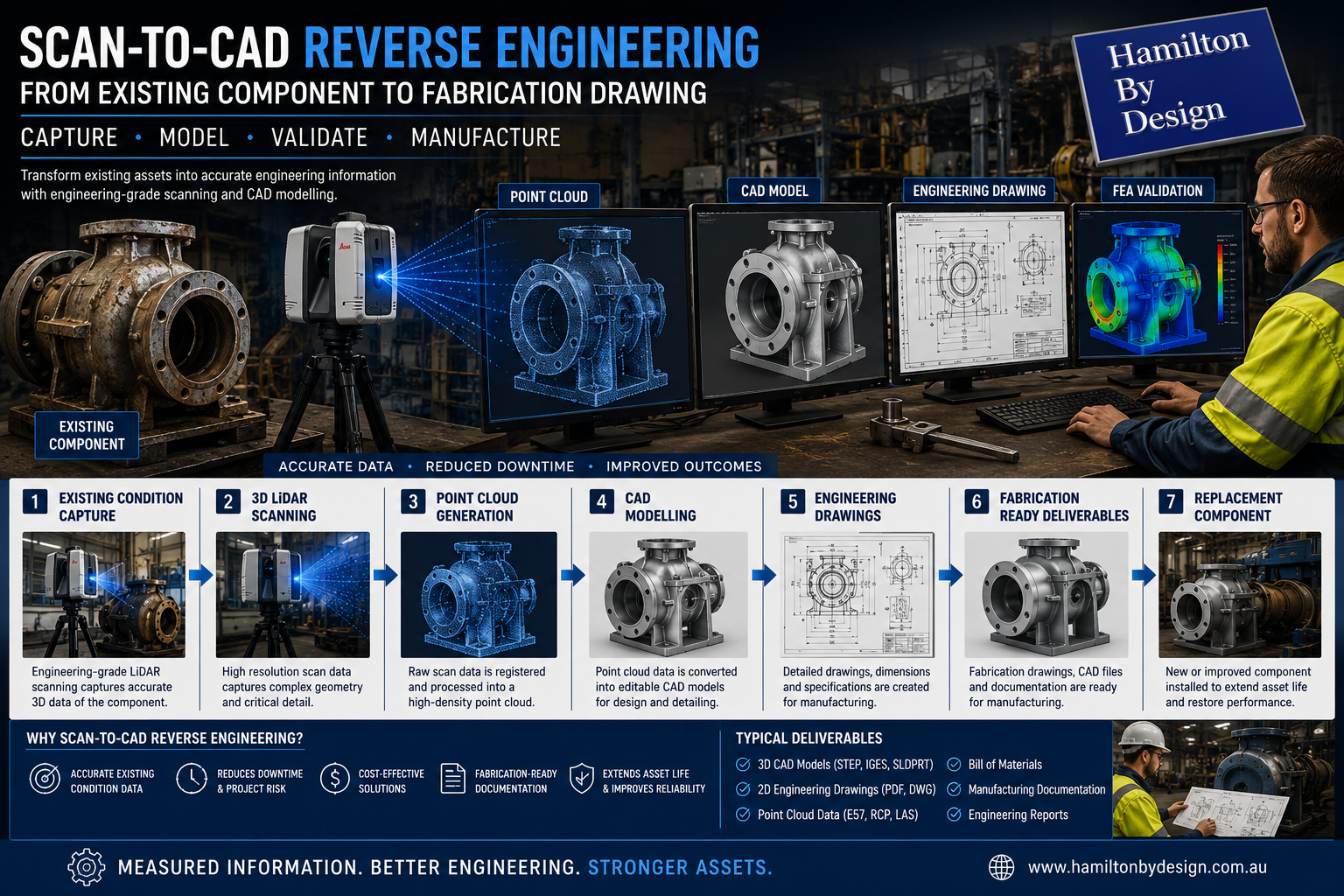
Engineering-grade Scan-to-CAD reverse engineering workflow converting existing industrial equipment into CAD models and fabrication-ready drawings.

Industrial facilities commonly rely on equipment that has operated for many years through upgrades, repairs, and ongoing modifications. Over time, engineering drawings may be lost, equipment may be altered from original configurations, or replacement components may become difficult to source.

When maintenance teams need to reproduce a component or modify an existing system, the challenge often becomes clear:

“We have the physical component, but we do not have the engineering information.”

Reverse engineering supported by Scan-to-CAD workflows provides a practical solution by converting physical assets into accurate digital engineering information.

At Hamilton By Design, we combine engineering-grade 3D LiDAR scanning, CAD modelling, and engineering documentation to transform existing components into fabrication-ready deliverables that support maintenance, upgrades, and improved asset management.

What is Scan-to-CAD Reverse Engineering?

Scan-to-CAD reverse engineering involves capturing a physical object or existing asset and converting it into editable engineering models and documentation.

Rather than relying on manual measurements or assumptions, engineering teams can create digital representations based on accurate measured information.

The workflow typically moves through:

Physical Component → Digital Capture → CAD Model → Engineering Documentation → Fabrication

The objective is creating engineering information that can support manufacturing and future asset management.

Existing Condition Capture

Reverse engineering begins with understanding the actual condition of an existing component.

Equipment operating in mining and industrial environments commonly experiences:

  • Wear
  • Modifications
  • Distortion
  • Repairs
  • Build-up
  • Material loss
  • Damage

Capturing existing conditions accurately becomes critical.

Typical assets may include:

  • Pump components
  • Shafts
  • Conveyor systems
  • Transfer chutes
  • Structural components
  • Wear liners
  • Mechanical assemblies
  • Processing equipment

Accurate existing condition capture reduces uncertainty before engineering work begins.

3D CAD Modelling Australia service banner for Hamilton By Design

Engineering-Grade 3D LiDAR Scanning

Hamilton By Design uses engineering-grade 3D LiDAR scanning to capture component geometry and surrounding environments.

LiDAR scanning can capture:

  • Complex geometry
  • Existing plant layouts
  • Mechanical equipment
  • Structural components
  • Dimensional relationships
  • Access constraints

Benefits may include:

  • Reduced manual measurement requirements
  • Improved accuracy
  • Faster information capture
  • Existing condition verification
  • Reduced engineering assumptions

Point Cloud Generation

Following site capture, scan information is processed into a point cloud dataset.

Point clouds provide:

  • Measured spatial information
  • Existing geometry
  • Dimensional verification
  • Digital representation of physical assets

Point cloud information becomes the foundation for further engineering development.

Point cloud deliverables may include:

  • .E57 files
  • .RCP files
  • .LAS files
  • Registration reports

Rather than relying on estimated dimensions, engineering decisions can be based on measured information.

CAD Modelling

Once point cloud information is generated, components can be converted into editable engineering models.

CAD modelling allows engineers to create:

  • Parametric models
  • Mechanical assemblies
  • Manufacturing geometry
  • Equipment layouts
  • Design modifications
  • Engineering improvements

Benefits include:

  • Improved visualisation
  • Future design flexibility
  • Digital asset information
  • Improved project coordination

For reverse engineering projects, editable CAD models become valuable long-term assets.

Engineering Drawings

Digital models can then be transformed into engineering documentation supporting fabrication and manufacturing activities.

Typical outputs include:

  • General arrangement drawings
  • Detail drawings
  • Assembly drawings
  • Dimensional drawings
  • Manufacturing drawings
  • Bills of materials

Documentation provides manufacturing teams with clear information for production.

Fabrication-Ready Deliverables

The final stage involves developing information that supports practical project execution.

Hamilton By Design deliverables may include:

  • 3D CAD models
  • PDF engineering drawings
  • DWG files
  • STEP files
  • Point cloud datasets
  • Manufacturing documentation
  • Engineering reports

The goal is delivering information that moves beyond visualisation and becomes usable engineering data.

Why Scan-to-CAD Matters for Reverse Engineering

Without digital engineering workflows, organisations may face:

  • Manual measurement errors
  • Missing information
  • Extended downtime
  • Increased fabrication risk
  • Higher project costs
  • Rework during installation

Scan-to-CAD workflows can improve:

  • Accuracy
  • Planning
  • Asset management
  • Fabrication outcomes
  • Project confidence
  • Long-term equipment support
3D LiDAR scanning and 3D modelling service button — laser scanner capturing a point cloud for engineering and CAD modelling
Mechanical engineering services

How Hamilton By Design Supports Reverse Engineering Projects

Hamilton By Design combines practical engineering experience with digital engineering tools including:

  • Engineering-grade 3D LiDAR scanning
  • Existing condition capture
  • Scan-to-CAD workflows
  • CAD modelling
  • Engineering drawings
  • Fabrication documentation
  • Reverse engineering services

The objective is not simply reproducing components.

The objective is transforming existing assets into accurate engineering information that supports maintenance, manufacturing, and long-term operational performance.

Measured information creates better engineering outcomes than assumptions.

Our Clients:

Hamilton By Design logo displayed on a blue tilted rectangle with a grey gradient background
Name
Would you like us to arrange a phone consultation for you?
Address
3D CAD Modelling Australia service banner for Hamilton By Design
Australian Drafting logo featuring bold white text reading "Australian Drafting" centred on a blue rounded rectangle background.
Engineering Governance title graphic featuring bold white text reading "Engineering Governance" centred on a blue rounded rectangle background.
Mechanical, Structural & Pipework Drafting service banner by Hamilton By Design featuring white text on a blue background.
Mechanical engineering services
Blue rounded button with the text “SolidWorks Design” in white.
Finite Element Analysis (FEA) engineering simulation button
3D LiDAR Scanning Darwin for engineering surveys, laser scanning, reality capture and point cloud modelling services
3D LiDAR Scanning Australia engineering services for laser scanning, reality capture, scan-to-CAD, Scan-to-BIM and as-built documentation across Australia
3D LiDAR scanning services on the Central Coast providing engineering-grade laser scanning, point cloud capture, scan-to-CAD modelling and industrial reality capture for infrastructure and industrial projects.
3D LiDAR Scanning Perth for engineering surveys, laser scanning, reality capture and point cloud modelling services
3D LiDAR Scanning Sydney for engineering surveys, laser scanning, reality capture and point cloud modelling services
3D LiDAR Scanning Brisbane for engineering surveys, laser scanning, reality capture and point cloud modelling services
3D LiDAR Scanning Canberra for engineering surveys, laser scanning, reality capture and point cloud modelling services
3D LiDAR Scanning Newcastle for engineering surveys, laser scanning, reality capture and point cloud modelling services
3D LiDAR Scanning Adelaide for engineering surveys, laser scanning, reality capture and point cloud modelling services

Why Existing Conditions Matter: Reducing Safety Risks with Engineering-Grade LiDAR Scanning

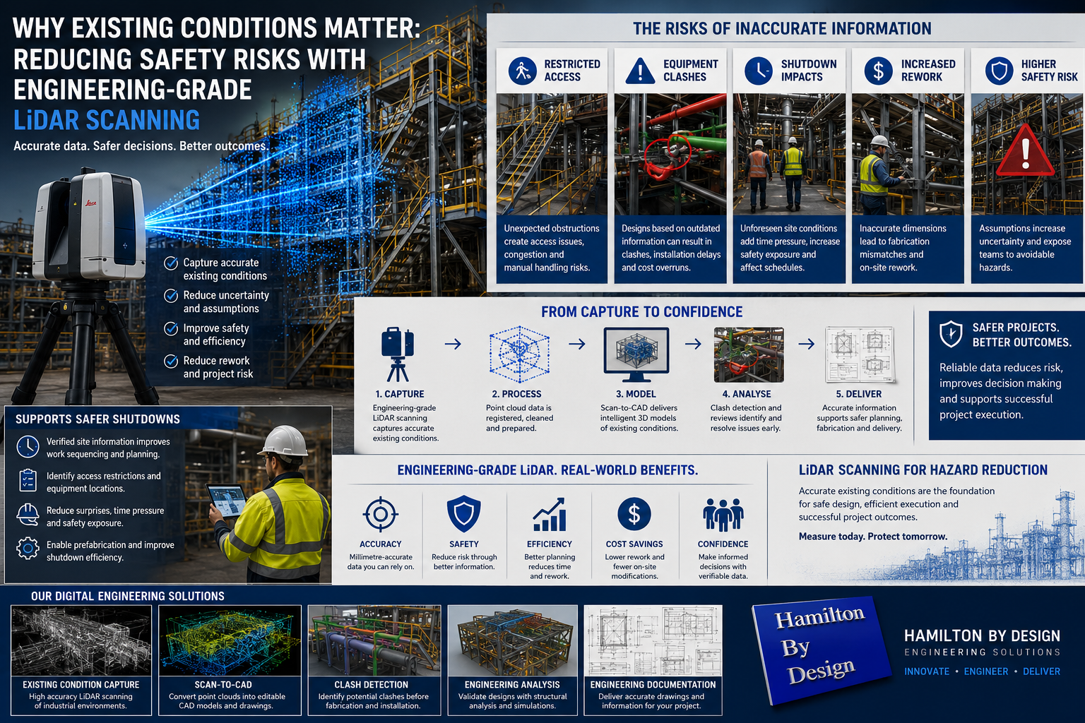
Engineering-grade LiDAR scanning workflow showing how existing condition capture reduces safety risks through clash detection, scan-to-CAD modelling, engineering analysis, and improved shutdown planning in industrial facilities.

Industrial projects are often built around a simple assumption:

“The existing drawings are correct.”

Unfortunately, in many industrial facilities that assumption can introduce significant risk.

Mining plants, processing facilities, manufacturing sites, and timber processing operations commonly undergo years or decades of modifications. Equipment changes, structural additions, maintenance alterations, temporary fixes, and undocumented upgrades can gradually move facilities away from their original engineering documentation.

When engineering decisions are based on outdated drawings or manual measurements, project teams may unknowingly introduce safety risks that affect shutdown activities, maintenance work, and plant upgrades.

At Hamilton By Design, engineering-grade LiDAR scanning supports safer project outcomes by replacing assumptions with measurable site information.

Why Existing Conditions Matter

Existing conditions represent the actual site environment rather than what historical drawings suggest exists.

In industrial environments, discrepancies can develop through:

  • Historical modifications
  • Unrecorded changes
  • Structural alterations
  • Equipment replacements
  • Temporary repairs becoming permanent solutions
  • Missing documentation
  • Inaccurate field measurements

A few centimetres of difference can appear minor on a drawing but become significant when:

  • Installing new equipment
  • Modifying conveyor systems
  • Designing platforms
  • Routing pipework
  • Planning shutdown activities
  • Fabricating structural steel

Small errors can create larger project impacts.

Safety Risks Created by Inaccurate Information

Assumptions can introduce several operational and safety challenges.

3D CAD Modelling Australia service banner for Hamilton By Design

Examples include:

Restricted Access Areas

Access routes may differ from original layouts, creating:

  • Maintenance access issues
  • Congestion
  • restricted clearances
  • Manual handling risks

Equipment Clashes

New designs based on incorrect information may result in:

  • Structural clashes
  • Pipework interferences
  • Equipment conflicts
  • Installation delays

Increased Exposure During Shutdown Activities

Shutdown periods often involve:

  • Tight schedules
  • Multiple work groups
  • Limited access windows
  • High activity levels

Unexpected site conditions discovered during shutdowns can increase:

  • Time pressure
  • Additional field modifications
  • Safety exposure
  • Project costs

Brownfield Projects Present Additional Challenges

Brownfield environments rarely match original design documentation.

Common challenges include:

  • Congested plant layouts
  • Existing services
  • Structural interferences
  • Legacy equipment
  • Multiple generations of modifications

Designing around assumptions in these environments increases uncertainty.

Existing Condition Capture Using Engineering-Grade LiDAR

Engineering-grade LiDAR scanning captures existing conditions by collecting highly accurate site geometry and generating point cloud data.

Capture can include:

  • Structural steel
  • Platforms
  • Conveyors
  • Pipework
  • Equipment
  • Buildings
  • Access systems
  • Existing plant layouts

Rather than relying solely on manual measurements, project teams gain access to measurable site information.

Benefits can include:

  • Improved accuracy
  • Existing condition verification
  • Better planning
  • Reduced uncertainty
  • Reduced installation risk

Clash Detection Before Construction

Once captured, point cloud information can be integrated into engineering workflows.

Scan-to-CAD processes allow:

  • Existing condition modelling
  • Design development
  • Clash detection
  • Constructability reviews
  • Layout optimisation

Potential problems can be identified before fabrication and site installation begin.

Finding issues digitally generally costs less than discovering them during construction activities.

Supporting Shutdown Planning

Shutdown windows are often measured in hours or days rather than weeks.

Unexpected field discoveries can quickly affect:

  • Production schedules
  • Labour requirements
  • Equipment availability
  • Project budgets

LiDAR scanning can support shutdown planning by:

  • Capturing actual site conditions
  • Identifying access restrictions
  • Verifying equipment locations
  • Improving work sequencing
  • Supporting prefabrication

Better information often leads to more predictable project execution.

Reducing Site Rework

Rework commonly results from:

  • Inaccurate dimensions
  • Design clashes
  • Existing condition errors
  • Fabrication mismatches

Reducing rework can improve:

  • Safety performance
  • Project schedules
  • Labour efficiency
  • Installation outcomes
  • Overall project cost

How Hamilton By Design Supports Safer Industrial Projects

Hamilton By Design combines practical engineering experience with digital engineering workflows to support safer project delivery.

Services can include:

Engineering-Grade LiDAR Scanning

Capture accurate site geometry and existing conditions.

Scan-to-CAD Workflows

Convert point cloud information into:

  • Editable CAD models
  • Engineering drawings
  • Existing condition layouts

Engineering Analysis

Support project decisions through:

  • Design validation
  • Engineering reviews
  • Structural assessment
  • Simulation and analysis
3D LiDAR scanning and 3D modelling service button — laser scanner capturing a point cloud for engineering and CAD modelling
Mechanical engineering services

Engineering Documentation

Deliver:

  • General arrangement drawings
  • Fabrication drawings
  • Engineering models
  • Project information

Moving Beyond Assumptions

Existing conditions influence safety, constructability, and project outcomes.

When projects rely on assumptions rather than measurable information, risks can increase.

Engineering-grade LiDAR scanning helps organisations move from:

Estimated conditions → Verified conditions

The result is improved confidence, reduced risk, safer project execution, and better engineering decisions.

Finite Element Analysis (FEA) engineering simulation button
Mechanical engineering services

Engineer-Led Scan to CAD Services in Singleton NSW

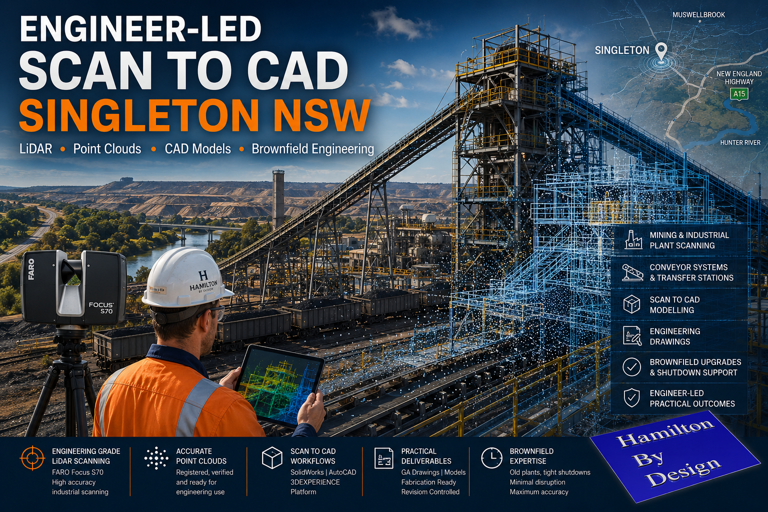
Engineer-led scan to CAD services in Singleton NSW using industrial LiDAR scanning, point cloud modelling and brownfield engineering workflows for Hunter Valley mining infrastructure.

Engineer-Led Scan to CAD Services Singleton NSW | Industrial LiDAR Engineering

Blue 3D LiDAR scanner icon on a tripod with scanning waves

Mining and industrial facilities across Singleton and the wider Hunter Valley continue to operate within complex brownfield environments. Many plants have evolved over decades through shutdown upgrades, emergency modifications, structural alterations and conveyor system changes. In many cases, original drawings no longer reflect actual site conditions.

Hamilton By Design provides engineer-led scan-to-CAD services in Singleton NSW, helping mining and industrial operations convert real-world site conditions into practical engineering deliverables using engineering-grade LiDAR scanning and CAD modelling workflows.

Unlike general scanning providers that focus only on collecting point cloud data, our workflows are built around mechanical engineering, structural drafting and industrial plant modification projects.

Engineering-Grade LiDAR Scanning for Industrial Environments

Industrial plants present unique challenges that require more than basic reality capture.

Conveyor systems, transfer towers, maintenance platforms, pump skids, structural steel, pipework and access systems all require accurate understanding of existing geometry before fabrication or installation begins.

Hamilton By Design uses engineering-grade terrestrial LiDAR systems including the FARO Focus S70 to capture accurate site conditions within mining and industrial environments across Singleton and the Hunter Valley.

3D CAD Modelling Australia service banner for Hamilton By Design

Our services support:

  • Coal Handling Preparation Plants (CHPP)
  • Conveyor systems and transfer stations
  • Structural steel modifications
  • Mining workshops
  • Maintenance access platforms
  • Pipework upgrades
  • Brownfield plant expansions
  • Shutdown engineering projects
  • Mechanical equipment layouts
  • Industrial drafting and modelling workflows

Why Scan to CAD Matters in Brownfield Mining Environments

Many industrial projects fail due to inaccurate site information.

Legacy drawings may not reflect years of plant modifications, undocumented steelwork changes or conveyor alterations completed during shutdown periods. Small discrepancies in field measurements can result in fabrication errors, installation clashes and costly project delays.

Engineer-led scan-to-CAD workflows help reduce these risks by providing accurate as-built information before design and fabrication begins.

Accurate point cloud data allows engineering teams to:

  • Verify existing plant geometry
  • Identify clashes before fabrication
  • Reduce rework during shutdowns
  • Improve fit-up accuracy
  • Validate structural interfaces
  • Improve safety planning
  • Coordinate multiple contractors
  • Support fabrication-ready drafting

For mining and industrial facilities operating under tight shutdown windows, accurate site data can significantly improve planning confidence and reduce construction risk.

Engineer-Led Workflows — Not Just Point Clouds

Hamilton By Design operates as an engineer-led organisation.

This means the scanning process is aligned with downstream engineering outcomes rather than simply delivering large volumes of unmanaged scan data.

Our workflows are designed to support:

  • Mechanical engineering
  • Structural engineering
  • Fabrication detailing
  • General arrangement drafting
  • Engineering governance
  • Revision-controlled documentation
  • Brownfield plant integration

We understand that industrial projects require practical deliverables that can move into fabrication, procurement and construction workflows.

3D LiDAR Scanning Hunter & Newcastle banner with white text on a blue background promoting engineering-grade laser scanning services for industrial, mining and infrastructure projects across the Hunter Valley and Newcastle region.
Mechanical Engineering Hunter & Newcastle banner promoting mechanical engineering services for mining, industrial plants, power generation, manufacturing and heavy industry throughout the Hunter Valley and Newcastle region.
Structural Drafting Hunter & Newcastle banner promoting structural drafting services for mining, industrial plants, power generation, manufacturing and infrastructure projects across the Hunter Valley and Newcastle region.

Typical Scan to CAD Workflow

1. Site LiDAR Scanning

Engineering-grade LiDAR scanners are used to capture existing site conditions across the required plant area.

Typical environments include:

  • Conveyors
  • Transfer towers
  • Access platforms
  • Pipework systems
  • Structural steel
  • Mechanical equipment
  • Processing infrastructure

2. Point Cloud Registration

Scan data is processed and registered using industrial workflows to align scans into a coordinated point cloud environment.

Deliverables may include:

  • Registered point clouds
  • Scan location plans
  • Registration reports
  • .E57 exports
  • .RCP exports
  • .LAS exports

3. Scan to CAD Modelling

Point cloud data is converted into practical engineering models and drafting outputs using platforms such as:

  • SolidWorks
  • AutoCAD
  • 3DEXPERIENCE Platform

4. Engineering Deliverables

Final deliverables may include:

  • General arrangement drawings
  • Structural layouts
  • Mechanical drafting
  • Conveyor layouts
  • Fabrication-ready models
  • Revision-controlled PDF issue packs

Supporting Singleton and Hunter Valley Industry

Singleton remains one of Australia’s most significant mining and industrial regions, supporting coal operations, bulk materials handling infrastructure and heavy industrial maintenance activities throughout the Hunter Valley.

Hamilton By Design supports companies operating across Singleton and surrounding regions by providing practical engineering-focused scanning and modelling workflows designed specifically for industrial environments.

Our focus is not on marketing-driven promises or unrealistic scanning claims.

Our focus is on delivering practical engineering outcomes that support real-world industrial projects.

3D LiDAR scanning and 3D modelling service button — laser scanner capturing a point cloud for engineering and CAD modelling
Mechanical engineering services

Engineering Governance and Drawing Control

Industrial projects require more than accurate geometry.

Engineering governance, revision control and drawing lifecycle management remain critical for long-term project success.

Hamilton By Design can support structured engineering workflows through controlled drafting environments and the 3DEXPERIENCE platform, helping maintain:

  • Revision history
  • Controlled approvals
  • Issue status management
  • Audit traceability
  • Single source of truth documentation

This becomes increasingly important on large industrial and shutdown projects involving multiple stakeholders and contractors.

Hamilton By Design logo displayed on a blue tilted rectangle with a grey gradient background

Planning a Brownfield Upgrade in Singleton?

If your operation is planning a conveyor upgrade, plant modification, shutdown project or industrial expansion in Singleton NSW, Hamilton By Design can assist with engineer-led scan-to-CAD and industrial LiDAR workflows tailored to mining and heavy industrial environments.

For more information, lets connect

Name
Would you like us to arrange a phone consultation for you?
Address

Our clients

3D CAD Modelling Australia service banner for Hamilton By Design
CHPP Engineering title graphic featuring bold white text reading "CHPP Engineering" centred on a blue rounded rectangle background.
Pipework Drafting title graphic featuring bold white text reading "Pipework Drafting" centred on a blue rounded rectangle background.
3D LiDAR Scanning for Engineering Projects title graphic featuring bold white text on a blue rounded rectangle background.
Finite Element Analysis (FEA) engineering simulation button
Structural drafting services button
Mechanical drafting services button
Mechanical engineering services
Australian Drafting logo featuring bold white text reading "Australian Drafting" centred on a blue rounded rectangle background.

3D LiDAR Scanning for Fit-Outs, Engineering and As-Built Verification

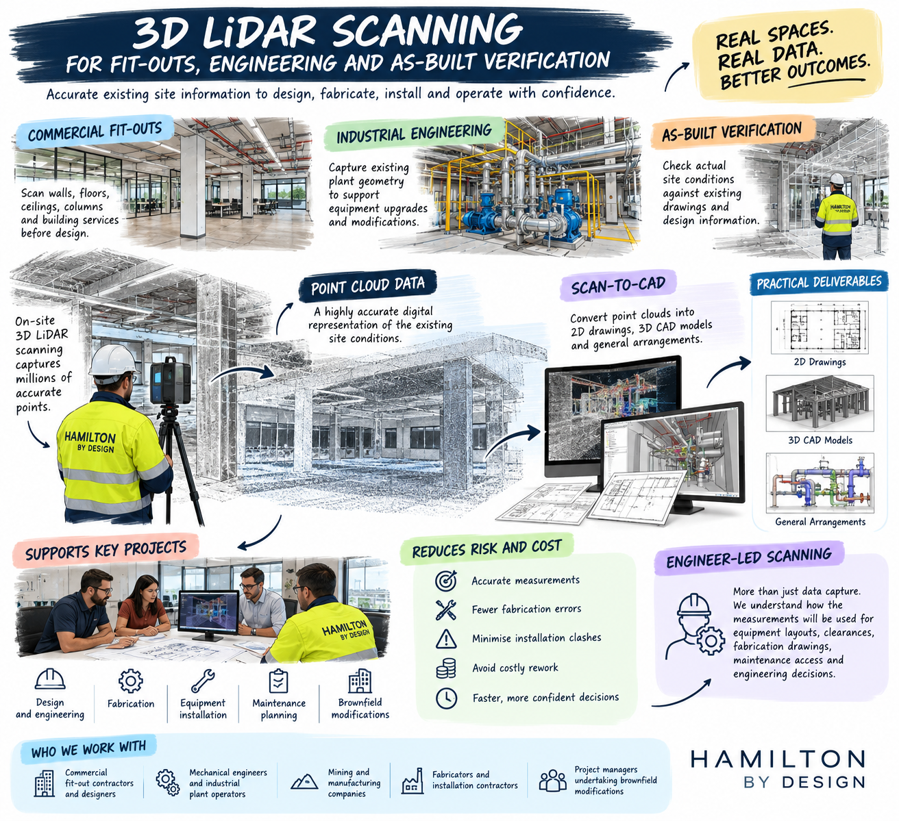
3D LiDAR scanning for commercial fit-outs, industrial engineering and as-built verification by Hamilton By Design, illustrating point cloud capture, scan-to-CAD modelling, engineering drawings and plant modifications.

3D LiDAR Scanning for Fit-Outs, Engineering & As-Built Verification | Hamilton By Design

For high-quality fit-outs, industrial upgrades and brownfield engineering projects, accurate site information matters before design work begins.

Blue 3D LiDAR scanner icon on a tripod with scanning waves

Hamilton By Design provides engineer-led 3D LiDAR scanning, point cloud processing and scan-to-CAD services for clients who need reliable site data for mechanical, structural and fit-out projects.

We do not promise what cannot be delivered. Every site is different, and every client needs a different level of information. Our role is to understand the project, capture the required data, and provide practical deliverables that support design, fabrication, installation and approval.

Why 3D LiDAR Scanning Matters

Fit-out and engineering projects often fail when drawings do not match the real site.

Walls may not be square. Floors may not be level. Services may have moved. Structural steel, pipework, ducts, cable trays and access constraints may not be shown correctly on older drawings.

3D LiDAR scanning helps capture the existing conditions before decisions are made.

This can assist with:

  • retail and commercial fit-outs
  • mechanical plant upgrades
  • structural steel modifications
  • brownfield industrial projects
  • conveyor, chute and pipework layouts
  • plant rooms and service corridors
  • fabrication and installation planning
  • as-built verification
  • scan-to-CAD modelling
3D CAD Modelling Australia service banner for Hamilton By Design

Engineer-Led Scanning, Not Just Survey Data

Hamilton By Design predominantly works with terrestrial LiDAR sensors for engineering-grade site capture. We also have access to SLAM scanning technology where the project suits that method.

The difference is not just the scanner. The difference is understanding what the scan is being used for.

A real estate scan may help sell or present a property. An engineering scan may need to support design decisions, clearances, fabrication drawings, structural interfaces, maintenance access and construction risk.

We can work with real estate agents if they want to pay mining and engineering industry rates. However, our main focus is mechanical, structural and industrial clients who need accurate data for real project outcomes.

Applications for Fit-Out and Commercial Projects

High-end fit-outs often require a detailed understanding of the existing building envelope. Cabinetry, counters, displays, ceilings, lighting, mechanical services and architectural features all need to fit within the real space.

A 3D point cloud can help designers and project teams review:

  • walls, floors and ceiling levels
  • columns, beams and bulkheads
  • mechanical, electrical and plumbing services
  • access restrictions
  • floor changes and set-downs
  • existing structural constraints
  • space available for custom joinery or equipment

This can reduce the risk of site rework, poor fit-up, late design changes and installation delays.

Applications for Industrial and Mining Projects

Hamilton By Design is especially suited to industrial and mining environments where site conditions are complex and the consequences of poor measurement are higher.

We assist with:

  • mechanical equipment layouts
  • structural steel layouts
  • conveyor and transfer point upgrades
  • pipework and pump skids
  • shutdown planning
  • brownfield plant modifications
  • access and maintenance reviews
  • clash checking against existing conditions
  • CAD models and drawings from point cloud data

Deliverables

Depending on the project, deliverables may include:

  • registered point clouds
  • scan location plans
  • 2D plans, sections and elevations
  • 3D CAD models
  • general arrangement drawings
  • fabrication support drawings
  • as-built records
  • marked-up review packs
  • engineering design support

We only provide the level of detail required for the project. Some clients only need registered point clouds. Others need CAD models, drawings and engineering input.

Our Approach

  1. Understand the project purpose
  2. Confirm the level of detail required
  3. Select the right scanning method
  4. Capture the site safely and efficiently
  5. Register and process the point cloud
  6. Develop CAD or drawing outputs where required
  7. Support review, design and fabrication decisions
3D LiDAR scanning and 3D modelling service button — laser scanner capturing a point cloud for engineering and CAD modelling
Mechanical engineering services

Why Work With Hamilton By Design

Hamilton By Design combines 3D LiDAR scanning with mechanical and structural engineering experience.

That means we are not only capturing geometry. We are thinking about how the data will be used by engineers, fabricators, project managers, installers and asset owners.

For projects where accuracy, access, fit-up and engineering judgement matter, engineer-led scanning can provide better value than a low-cost scan with no design understanding.

Call to Action

Need accurate site data before design, fabrication or fit-out work begins?

Contact Hamilton By Design to discuss 3D LiDAR scanning, point cloud processing and scan-to-CAD support for your next project.

Finite Element Analysis (FEA) engineering simulation button
Mechanical engineering services