Mechanical Engineering | 3D Scanning | 3D Modelling
Tag: Greater Sydney
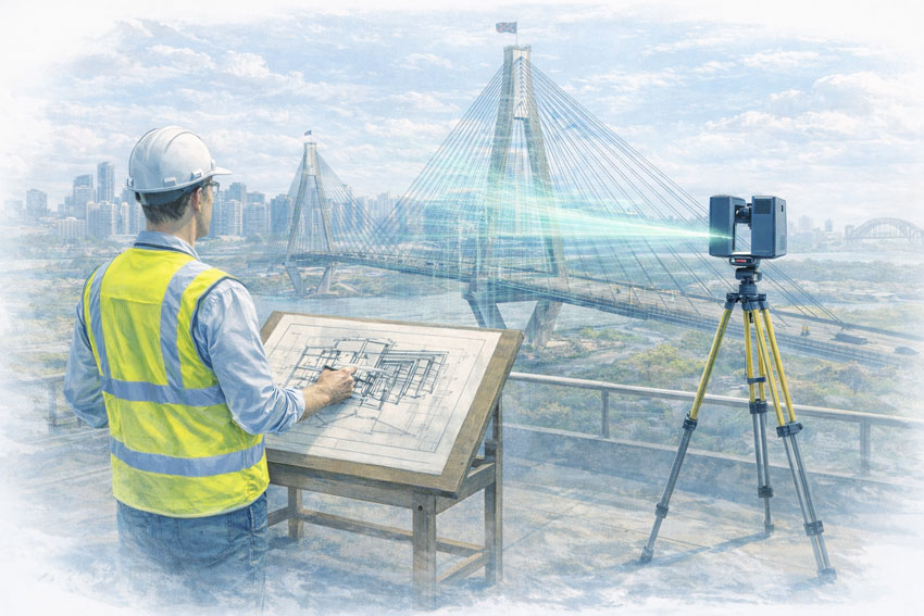
Engineering services across Greater Sydney including engineering-grade 3D laser scanning, LiDAR, scan-to-CAD, mechanical design, drafting, reverse engineering, and industrial project support for mining and heavy industry.
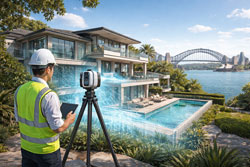
3D Laser Scanning in Kirribilli NSW – Engineering-Grade Reality Capture for Harbour-Side Projects
Harbour-side buildings and infrastructure present unique challenges for refurbishment, compliance and upgrade works. Tight access, ageing structures and complex services make accurate site data critical before design or construction begins.
Hamilton By Design provides engineering-grade 3D laser scanning and LiDAR services in Kirribilli and across Sydney’s Lower North Shore, delivering accurate point cloud data that supports safe, buildable and cost-effective engineering outcomes.
Why 3D Scanning Is Critical in Kirribilli and Harbour Precincts
Kirribilli is characterised by:
heritage and character buildings
dense strata developments
limited access for survey and construction
proximity to critical transport and harbour infrastructure
Traditional measurement methods are often inadequate for:
structural modifications
mechanical plant upgrades
access compliance works
fabrication-ready design
3D laser scanning captures millions of accurate spatial data points, creating a true digital record of existing conditions before design begins — reducing rework, RFIs and site clashes.
From Point Cloud to Build-Ready CAD and BIM Models
Our service does not stop at site capture.
We convert scan data into:
engineering CAD models
fabrication drawings
BIM-compatible geometry
detailed as-built documentation
This supports downstream workflows such as:
steel fabrication
mechanical installation
access system upgrades (AS 1657)
structural strengthening designs
Deliverables are tailored to suit engineers, architects and construction teams — not just visualisation.
Typical Applications in Kirribilli and the Lower North Shore
3D scanning is commonly used for:
strata refurbishments and upgrades
heritage façade documentation
lift and stair compliance modifications
plant room reconfiguration
services routing and clash detection
harbour-adjacent infrastructure assessments
Because scanning is non-contact and fast to deploy, it allows data capture in occupied buildings with minimal disruption to residents and businesses.
Engineering-Led Scanning — Not Just Survey Output
Hamilton By Design is an engineering-led consultancy, not just a scanning provider.
This means:
scan planning is driven by design requirements
critical interfaces are prioritised
modelling supports fabrication and construction
risk is addressed early in the project lifecycle
This approach is particularly valuable in brownfield and retrofit environments where unknown conditions often drive cost overruns.
Servicing Kirribilli, North Sydney and Sydney Harbour Precincts
We regularly support projects across:
Kirribilli
Milsons Point
North Sydney
Neutral Bay
Chatswood
Sydney CBD
And integrate scanning with mechanical, structural and drafting services where required.
Whether the project involves refurbishment, compliance or asset documentation, accurate reality capture forms the foundation for reliable engineering decisions.
Supporting Safe Design and Risk Reduction
Accurate site data enables:
early hazard identification
better access system design
improved constructability reviews
reduced site modifications during shutdowns
This aligns with Safe Design principles and reduces downstream safety and scheduling risks.
Talk to Us About 3D Scanning in Kirribilli
If you’re planning refurbishment, compliance upgrades or engineering works in Kirribilli or across Sydney’s harbour precincts, engineering-grade 3D scanning can eliminate costly unknowns before construction begins.
Contact Hamilton By Design to discuss site capture, modelling and design support for your project.
3D Scanning in Greater Sydney NSW | Point Cloud to BIM & Digital Twins for Smarter Projects
Across Greater Sydney — including industrial hubs like Blacktown — asset owners and project teams are under increasing pressure to deliver upgrades, expansions, and maintenance projects with less downtime and lower risk. In congested brownfield environments, the biggest challenge is often not design — it is knowing exactly what already exists on site.
This is where engineering-grade 3D laser scanning and point cloud to BIM workflows are transforming the way projects are planned and delivered across NSW.
At Hamilton By Design, we support industrial and infrastructure projects by converting accurate site data into practical engineering models that improve project certainty from concept through to construction.
Why Accurate Site Data Matters in Greater Sydney
Many industrial facilities across Greater Sydney have evolved over decades. Services are added, conveyors rerouted, platforms extended, and temporary fixes become permanent. Unfortunately, drawings are rarely updated to reflect these changes.
For project managers, this creates risks such as:
Late discovery of clashes during installation
Unplanned scope changes and shutdown delays
Increased safety exposure during site rework
Cost overruns due to fabrication errors
Without accurate as-built data, project planning becomes reactive instead of proactive.
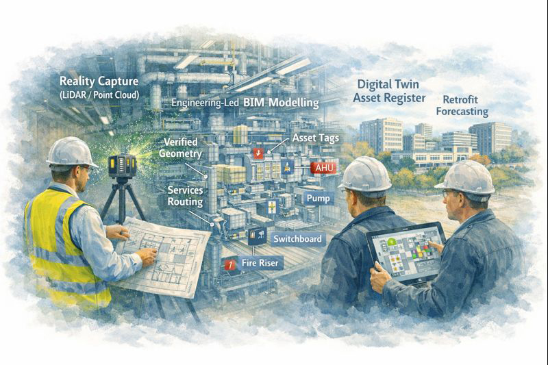
From 3D Scanning to Point Cloud to BIM
Using engineering-grade LiDAR scanners, we capture millions of spatial data points across entire facilities, producing highly accurate point clouds that represent the real-world geometry of structures, conveyors, services, and equipment.
These point clouds are then converted into:
BIM-ready 3D models
Fabrication-ready CAD geometry
Digital twins for ongoing asset management
This point cloud to BIM process allows project teams to design, coordinate, and review upgrades in a digital environment before any physical work begins.
For project management, this means fewer surprises and far better control over scope, schedule, and cost.
Digital Twin Creation for Ongoing Asset Management
Beyond individual projects, many asset owners in NSW are now adopting digital twins to manage facilities across their full lifecycle.
A digital twin created from accurate scan data allows teams to:
Visualise plant layouts remotely
Plan future upgrades with confidence
Improve maintenance access planning
Support safety reviews and training
In multi-site operations across Greater Sydney, digital twins also support consistent engineering standards and faster project scoping.
Rather than starting from scratch for every shutdown, project teams can build on a continually updated digital asset model.
Supporting Conveyor Design in Brownfield Environments
Conveyor systems remain critical to manufacturing, logistics, waste processing, and bulk materials handling facilities across Sydney’s western suburbs, including Blacktown and surrounding industrial precincts.
When conveyors are upgraded or rerouted, spatial constraints often drive:
Poor maintenance access
Compromised guarding
Clashes with services and structures
Scan-based conveyor modelling allows engineers to:
Verify belt paths, transfer points, and head drives
Design guarding that fits existing structures
Improve access platforms and walkways
Reduce installation time during shutdowns
For project managers, this directly translates into reduced safety risk and fewer installation delays.
Project Management Benefits of 3D Scanning
From a project delivery perspective, engineering-grade scanning supports:
More accurate scope definition
Better contractor coordination
Improved constructability reviews
Reduced variation claims
Safer installation planning
When all stakeholders are working from the same verified model, communication improves and decision-making becomes faster and more reliable.
This is particularly valuable on fast-tracked shutdown projects where every hour of downtime has a production cost.
Local Support Across Greater Sydney NSW
Hamilton By Design provides on-site 3D scanning, BIM modelling, and mechanical engineering support across Greater Sydney, including:
Blacktown
Western Sydney industrial precincts
Central Sydney infrastructure sites
Logistics and manufacturing facilities across NSW
As an engineering-led business, we integrate scanning directly into design, drafting, and fabrication support — ensuring that digital models deliver practical, buildable outcomes.
Our focus is not just capturing data, but turning it into engineering solutions that reduce risk and improve project performance.
Turning Reality Capture into Project Confidence
Whether planning a conveyor upgrade, plant expansion, or long-term asset management strategy, accurate site data is the foundation of successful delivery.
By moving from point cloud to BIM and digital twins, project teams across Greater Sydney are gaining better visibility, stronger risk control, and far greater confidence in their project outcomes.
Hamilton By Design provides engineering-led 3D scanning, LiDAR scanning, mechanical engineering and digital engineering services throughout Sydney and Greater Sydney.
Explore our related Sydney services:
3D Scanning Sydney – Engineering-grade terrestrial laser scanning, as-built surveys and point cloud capture for industrial, infrastructure and commercial projects.
Reality Capture Sydney – High-accuracy reality capture, digital twins, asset documentation and engineering-grade site verification.
Scan to CAD Sydney – Convert point cloud data into AutoCAD, SolidWorks, Inventor and other engineering-ready CAD deliverables.
Point Cloud Modelling Sydney– Engineering-grade point cloud processing, clash detection, as-built verification and 3D modelling.
Mechanical Engineering Sydney – Mechanical design, plant upgrades, materials handling systems, conveyors, chutes, platforms and engineering support.
Structural Drafting Sydney– Structural steel drafting, fabrication drawings, GA drawings, workshop detailing and as-built documentation.
Hamilton By Design supports projects throughout Sydney CBD, Parramatta, Liverpool, Penrith, Blacktown, Chatswood, Alexandria, Mascot, Newcastle and the Central Coast.
3D Laser Scanning for Conveyor Design & Safe Engineering in Parramatta
Parramatta continues to grow as a major industrial and infrastructure hub for Western Sydney. With ageing plant, frequent upgrades, and tighter safety expectations, many facilities are now turning to engineering-grade 3D laser scanning to improve the way conveyor systems and material handling equipment are designed, modified, and maintained.
At Hamilton By Design, we use high-accuracy LiDAR scanning to capture existing conditions and convert them into precise 3D models that engineers, designers, and maintenance teams can rely on — before anyone picks up a spanner or starts cutting steel.
Why Conveyor Systems Are High-Risk Assets
Conveyors are involved in a significant number of serious workplace incidents across Australia. Common contributors include:
Inadequate guarding and access control
Poor visibility of nip points and transfer zones
Modifications made without updated drawings
Space constraints forcing unsafe maintenance practices
In many older facilities around Parramatta, conveyors have been extended, rerouted, or repaired multiple times over decades — often without accurate as-built documentation. This creates real risk when new upgrades or safety improvements are planned.
Without reliable spatial data, design decisions are often made on assumptions, outdated drawings, or rough site measurements.
Engineering-Grade Scanning: Not Just “Pretty Pictures”
Not all 3D scans are suitable for engineering or safety-critical work.
We use engineering-grade LiDAR scanning capable of delivering dimensional accuracy of approximately ±2 mm over 70 metres, which allows us to:
Model conveyor structures, walkways, guards, and transfer stations
Detect clashes before fabrication
Verify compliance with safe access and guarding requirements
Support certified engineering design and sign-off
The resulting point cloud and CAD models become the foundation for proper conveyor design, safety reviews, and fabrication drawings.
This is critical when safe design obligations must be demonstrated under WHS legislation.
Supporting Safe Design from Concept to Commissioning
Safe Design is not just about guarding at the end of a project — it starts at the design stage.
By scanning your existing plant, we can support:
Risk assessments using accurate spatial context
Redesign of transfer points and access platforms
Guarding upgrades that actually fit the site
Maintenance access improvements without production impact
Because models are generated from real geometry, engineers can confidently design modifications knowing they will physically fit when installed.
This reduces shutdown risk, rework, and last-minute site changes — all common contributors to project delays and safety incidents.
Learning from Industry Incidents — and Preventing the Next One
Many conveyor-related incidents share similar root causes:
Poor access for cleaning or inspection
Unplanned modifications
Incomplete hazard identification during design
Reliance on legacy drawings that no longer match reality
3D scanning allows hazards to be identified early and reviewed by multiple stakeholders — engineering, safety, operations, and maintenance — using the same accurate model.
It also creates a permanent digital record of the asset at a point in time, which is invaluable for:
Incident investigations
Compliance documentation
Future upgrade planning
In high-risk environments, accurate data is not a luxury — it is a control measure.
Local Scanning and Engineering Support in Parramatta
Hamilton By Design provides on-site 3D scanning and engineering services across Parramatta and Western Sydney, supporting:
Conveyor upgrades and replacements
Safety improvement projects
Plant expansions and brownfield modifications
Fabrication and installation planning
Our team is engineering-led, meaning scanning is not treated as a standalone service — it is directly integrated into mechanical design, drafting, and project delivery.
We also provide fabrication-ready drawings and can support workshops with shop details derived directly from scan-based models.
From Point Cloud to Practical Outcomes
3D scanning is only valuable if it leads to better decisions on the ground.
Our workflow typically includes:
On-site LiDAR scanning with minimal disruption to operations
Registration and cleaning of point cloud data
Conversion into CAD models suitable for engineering design
Design development, safety reviews, and fabrication drawings
This ensures your project is driven by real-world data — not assumptions.
Related Sydney Services
Hamilton By Design provides engineering-led 3D scanning, LiDAR scanning, mechanical engineering and digital engineering services throughout Sydney and Greater Sydney.
Explore our related Sydney services:
3D Scanning Sydney – Engineering-grade terrestrial laser scanning, as-built surveys and point cloud capture for industrial, infrastructure and commercial projects.
Reality Capture Sydney – High-accuracy reality capture, digital twins, asset documentation and engineering-grade site verification.
Scan to CAD Sydney – Convert point cloud data into AutoCAD, SolidWorks, Inventor and other engineering-ready CAD deliverables.
Point Cloud Modelling Sydney– Engineering-grade point cloud processing, clash detection, as-built verification and 3D modelling.
Mechanical Engineering Sydney – Mechanical design, plant upgrades, materials handling systems, conveyors, chutes, platforms and engineering support.
Structural Drafting Sydney– Structural steel drafting, fabrication drawings, GA drawings, workshop detailing and as-built documentation.
Hamilton By Design supports projects throughout Sydney CBD, Parramatta, Liverpool, Penrith, Blacktown, Chatswood, Alexandria, Mascot, Newcastle and the Central Coast.
3D LiDAR Scanning for Industrial Facilities in Western Sydney | Engineering-Led Reality Capture
Engineering-Led Reality Capture for Safer, More Accurate Project Outcomes
Western Sydney is one of Australia’s most active industrial and construction corridors. From large-scale warehousing and manufacturing facilities to logistics hubs, utilities, and infrastructure assets, the region demands accurate site data, safe project delivery, and engineering accountability.
At Hamilton By Design, we provide engineering-led 3D LiDAR scanning services across Western Sydney to support industrial facilities through design, modification, shutdown planning, and asset upgrades—bridging the gap between site reality and build-ready engineering models.
Why Western Sydney Industrial Projects Demand Engineering-Grade Scanning
Industrial sites in Western Sydney often present complex challenges:
Live operations with limited access windows
Legacy assets with incomplete or outdated drawings
Tight safety requirements and compliance obligations
Cost pressure from construction programs and shutdown schedules
In these environments, assumptions are expensive. Engineering-grade reality capture removes uncertainty before it reaches site.
Hot Topics Driving Engineering & Construction Decisions
1. Safety Starts With Accurate Information
Safety in industrial facilities begins long before construction or installation.
3D LiDAR scanning allows engineers to:
Identify clashes before fabrication
Design access platforms, walkways, and guards accurately
Reduce site rework, hot works, and manual re-measurement
Support safer shutdown planning and installation sequencing
Accurate digital site data reduces exposure hours and lowers risk across the project lifecycle.
2. Australian Engineering Quality vs Low-Cost Shortcuts
Cheaper scanning or modelling options often focus on speed over accuracy—leaving engineers to resolve issues later on site.
Hamilton By Design’s approach is different:
Engineer-led scanning, not technician-only capture
Models developed with mechanical, structural, and fabrication intent
Practical site experience informing what actually matters in design
This Australian engineering know-how delivers defensible, buildable outcomes, not just visually impressive models.
3. Scan-to-CAD: Turning Reality Into Buildable Design
Industrial clients don’t just need point clouds — they need usable engineering deliverables.
Our scan-to-CAD workflows support:
Mechanical and structural design
Conveyor, plant, and equipment modifications
Brownfield upgrades and extensions
Fabrication-ready drawings
By aligning reality capture directly with CAD and engineering workflows, we reduce rework, RFIs, and late-stage changes.
4. Supporting Digital Twins for Industrial Assets
3D LiDAR scanning is increasingly used as the foundation for digital twins in industrial environments.
For Western Sydney facilities, this supports:
Asset documentation and lifecycle management
Future expansion planning
Maintenance access reviews
Engineering audits and compliance records
Reality capture ensures digital twins are based on what exists, not what drawings suggest.
Typical Western Sydney Industrial Applications
Hamilton By Design supports a wide range of industrial facilities across Western Sydney, including:
Warehouses and logistics centres
Manufacturing plants
Processing and handling facilities
Utilities and infrastructure assets
Brownfield industrial upgrades
Our services are suited to both small targeted scans and large-scale facility capture, depending on project needs.
How This Supports Sydney-Wide 3D Scanning Services
Western Sydney projects form a key part of our broader Sydney-based 3D scanning services, supporting engineering and construction projects across metropolitan and regional NSW.
By combining engineering oversight, LiDAR accuracy, and scan-to-CAD expertise, we help clients move from uncertainty to confident decision-making.
👉 Learn more about our engineering-led 3D scanning services across Sydney through our dedicated Sydney page.
(Use a partial-match internal link here — not exact-match anchor text.)
Speak With an Engineer
If you’re planning:
An industrial upgrade or expansion
A brownfield modification
A shutdown or complex installation
A scan-to-CAD workflow for engineering design
Hamilton By Design provides engineering-led 3D LiDAR scanning that supports safer, more predictable outcomes across Western Sydney.
Large-Scale LiDAR Scanning Across Sydney’s Built Environment
Sydney 3D LiDAR scanning is increasingly used to understand, document, and manage complex, large-scale assets where traditional surveying or manual measurement is impractical, unsafe, or incomplete.
Across Sydney, LiDAR scanning supports infrastructure owners, asset managers, engineers, and project teams who need accurate spatial data of buildings, structures, corridors, and public assets — often while those assets remain operational.
At Hamilton By Design, we use LiDAR as a reality capture tool for understanding scale, geometry, and condition, not just producing drawings.
What Makes LiDAR Scanning Different at City Scale
Unlike small-area scanning for fabrication, urban LiDAR scanning is about:
Capturing entire structures, not just components
Understanding geometry across long distances and height
Recording spatial relationships between assets
Creating a permanent digital record of existing conditions
This makes LiDAR particularly effective for:
Bridges and transport infrastructure
Towers and vertical structures
Campuses, precincts, and CBD assets
Waterfront and port facilities
Public and private buildings with restricted access
Common Uses of Sydney 3D LiDAR Scanning
LiDAR scanning in Sydney is frequently used for:
As-built condition documentation
Asset verification prior to upgrade or refurbishment
Structural geometry validation
Clearance and envelope studies
Planning and constructability assessments
Long-term asset management records
In many cases, LiDAR replaces assumptions, outdated drawings, or partial surveys with defensible spatial data.
Working in Live, Operational Environments
Sydney assets are rarely isolated or shutdown-friendly.
LiDAR scanning allows data capture:
Without disrupting operations
Without physical contact with structures
From safe stand-off locations
With repeatable, measurable accuracy
This is particularly valuable for:
Transport corridors
Public infrastructure
High-traffic urban locations
Heritage or difficult-access assets
Deliverables from a Sydney LiDAR Scan
Depending on project needs, deliverables may include:
Registered point clouds (E57 / RCP / RCS)
Plan, elevation, and section views
Reference geometry for engineering studies
Context models for planning and approvals
Baseline datasets for future comparison
LiDAR data can stand alone as a digital record, or be used to inform later engineering and design work.
LiDAR as a Risk-Reduction Tool
For many Sydney projects, LiDAR scanning is commissioned before design decisions are locked in.
Typical drivers include:
Uncertainty in existing documentation
Risk of clashes or spatial conflicts
Asset modifications in constrained environments
High cost of access or rework
By capturing reality early, project teams reduce:
Unknowns
Re-measurement
Design assumptions
Late-stage surprises
Our clients:
Sydney Experience with National Reach
While our scanning work spans Australia, Sydney projects benefit from experience gained on:
Large industrial sites
Infrastructure upgrades
Brownfield environments
High-risk, high-consequence assets
This ensures LiDAR data is captured with engineering awareness, even when the immediate output is not a fabrication model.
When Sydney 3D LiDAR Scanning Makes Sense
LiDAR scanning is worth considering when:
Assets are large, tall, or complex
Access is limited or unsafe
Existing drawings are incomplete
Geometry matters more than aesthetics
You need a defensible digital baseline
Start with Reality, Then Decide the Path Forward
Sydney 3D LiDAR scanning provides clarity before decisions are made — not after problems appear.
If you need reliable spatial data to support planning, verification, or future engineering work, we can help.
Connect with us by filling out the form below to discuss your Sydney LiDAR scanning requirements.
Hamilton By Design provides engineering-led 3D scanning, LiDAR scanning, mechanical engineering and digital engineering services throughout Sydney and Greater Sydney.
Explore our related Sydney services:
3D Scanning Sydney – Engineering-grade terrestrial laser scanning, as-built surveys and point cloud capture for industrial, infrastructure and commercial projects.
Reality Capture Sydney – High-accuracy reality capture, digital twins, asset documentation and engineering-grade site verification.
Scan to CAD Sydney – Convert point cloud data into AutoCAD, SolidWorks, Inventor and other engineering-ready CAD deliverables.
Point Cloud Modelling Sydney– Engineering-grade point cloud processing, clash detection, as-built verification and 3D modelling.
Mechanical Engineering Sydney – Mechanical design, plant upgrades, materials handling systems, conveyors, chutes, platforms and engineering support.
Structural Drafting Sydney– Structural steel drafting, fabrication drawings, GA drawings, workshop detailing and as-built documentation.
Hamilton By Design supports projects throughout Sydney CBD, Parramatta, Liverpool, Penrith, Blacktown, Chatswood, Alexandria, Mascot, Newcastle and the Central Coast.
Hamilton By Design delivers engineering-grade LiDAR scanning services throughout Sydney CBD, Parramatta, Liverpool, Penrith, Chatswood, Alexandria, Mascot, Newcastle and the Central Coast. Accurate point cloud data supports industrial upgrades, infrastructure projects, as-built documentation and engineering design activities.
Preserving Today’s Information for Tomorrow’s Engineering Decisions
Buildings are long-life assets, but the information describing how they were actually built is often short-lived. Drawings become outdated, undocumented changes accumulate, and critical details disappear once concrete is poured or walls are closed.
Hamilton By Design provides engineering-grade 3D scanning and as-built BIM documentation across Greater Sydney, capturing what actually exists on site and converting it into reliable, decision-ready information that supports maintenance, compliance, refurbishment, sustainability upgrades, and long-term asset planning.
The data we collect today supports the engineering choices of tomorrow.
BIM Is Not a Concept Model — BIM Is As-Built Truth
BIM is often misunderstood as a design or visualisation tool. In practice, BIM only becomes valuable when it documents what was actually built, not what was originally intended.
This approach ensures that BIM outputs reflect real geometry, tolerances, and interfaces, remain useful years after construction, and support future engineering decisions.
Why Preserving As-Built Information Matters
Once a building enters service, change is constant. Services are rerouted during refurbishments and fit-outs, structural elements are modified, penetrations are added, and access conditions evolve.
Without a verified baseline, future engineers are forced to rely on assumptions.
By combining engineering-grade 3D laser scanning in Sydney with fit-for-purpose BIM documentation, we create a defensible digital record of the asset at a known point in time: https://www.hamiltonbydesign.com.au/3d-scanning-sydney/
This record becomes a reference that can be trusted long after drawings, photos, and site knowledge have disappeared.
Capturing Information Before It Becomes Hidden
Timing is critical.
3D scanning delivers the greatest long-term value when undertaken before concrete is poured, before walls or gyprock are fixed, before ceilings are closed, or before major refurbishments begin.
Once these elements are concealed, understanding what exists becomes invasive, interpretive, and costly. Early-stage reality capture creates a permanent digital record of conditions that would otherwise be lost forever.
Engineering-Led Scan-to-BIM
Accurate BIM requires more than software. Our workflows are grounded in engineering-led decision making and documentation, ensuring models are aligned with how assets actually perform and are modified over time: https://www.hamiltonbydesign.com.au/mechanical-engineering-services/
This approach ensures BIM outputs are fit for real engineering use, suitable for upgrades and modification, defensible for compliance and due diligence, and useful for fabrication, coordination, and access planning.
Supporting Commercial Buildings Across Sydney
Greater Sydney contains some of the most complex built environments in Australia, including high-density CBD assets, mixed-use developments, healthcare facilities, campuses, and strata buildings with shared services.
Preserved as-built information reduces uncertainty and allows design teams to plan works with confidence rather than assumptions.
Supporting Long-Life Industrial and Production Assets
Industrial and production facilities demand a higher level of certainty. Equipment upgrades, maintenance access, and future expansion depend on knowing exactly what exists.
In these environments, preserved information is a core risk-management tool.
Defects Investigations in 5–10 Years’ Time
Many building defects do not appear immediately. Water ingress, façade issues, slab movement, services failures, and vibration complaints often emerge years after construction.
A verified as-built scan and BIM baseline allows future engineers to compare conditions over time, identify hidden interfaces and penetrations, reduce destructive investigation, and diagnose issues more efficiently.
Without preserved data, defect investigations often start with uncertainty.
Post-Event Documentation
When an event occurs, whether seismic movement, impact damage, fire, or storm, rapid and accurate documentation becomes critical.
3D scanning after an event can capture a defensible condition record, support engineering assessment and triage, inform reinstatement scope, and assist insurers, owners, and regulators.
When paired with earlier scans, change becomes measurable rather than speculative.
Designing for Sustainability and User Experience Over the Next 10 Years
Sustainability upgrades fail when as-built reality is wrong.
Over the next decade, many Sydney assets will pursue energy upgrades, electrification pathways, improved HVAC performance, and better occupant comfort.
Scan-backed BIM supports these outcomes by ensuring plant rooms and services routes are understood, space constraints are known early, upgrades are coordinated before trades mobilise, and disruption is minimised.
Better information leads to better engineering choices and better outcomes for building users.
Engineering Decisions That Stand the Test of Time
The long-term consequences of poor documentation are well understood in engineering. Decisions made today echo years later.
Accurate as-built information underpins compliance, safety, and long-term asset performance. While 3D scanning and BIM are not mandated by a single Australian regulation, the intent of Australia’s building codes, standards, and information-management frameworks relies on reliable, traceable documentation of what has actually been constructed.
National Construction Code (NCC)
National Construction Code
The National Construction Code establishes performance requirements for structure, fire safety, access, health, amenity, and services. Although the NCC does not prescribe BIM or laser scanning, it assumes building work is supported by accurate and verifiable documentation. Scan-derived as-built BIM supports this intent by reducing reliance on assumptions during refurbishment, compliance reviews, and future upgrades.
ISO 19650 – Information Management Using BIM
ISO 19650
ISO 19650 defines best practice for managing information throughout the lifecycle of a built asset. Preserving today’s information for tomorrow’s engineering decisions aligns directly with this standard, particularly where as-built BIM is informed by reality capture and maintained as a lifecycle information resource.
Relevant Australian Standards
AS 1100 AS 3600 AS/NZS 3000 AS/NZS 3500 ISO 55000
These standards rely on accurate representation of geometry, services, and constructed conditions. Reality capture and as-built BIM support their intent by improving clarity, traceability, and long-term usability of engineering information.
Hamilton By Design does not claim that BIM itself guarantees compliance. Instead, our workflows support the intent of the NCC, ISO 19650, and relevant Australian Standards by improving the quality and reliability of building information used for engineering decisions.
Coverage Across Greater Sydney
Hamilton By Design provides 3D scanning and BIM documentation across Greater Sydney, including Sydney CBD, North Sydney, Chatswood, Parramatta, Macquarie Park, Ryde, Homebush, Alexandria, Mascot, Botany, Bankstown, Liverpool, Blacktown, Penrith, Castle Hill, Bella Vista, Brookvale, Manly, Hurstville, Sutherland, Cronulla, and surrounding precincts.
The Data We Collect Today Supports the Engineering Choices of Tomorrow
3D scanning and as-built BIM are not about creating a digital model for today’s project alone. They are about preserving truth before it disappears, reducing uncertainty years later, enabling sustainable upgrades, and supporting safer, smarter engineering decisions across the life of an asset.
That is the real value of BIM.
Our clients
Related Sydney Services
Hamilton By Design provides engineering-led 3D scanning, LiDAR scanning, mechanical engineering and digital engineering services throughout Sydney and Greater Sydney.
Explore our related Sydney services:
3D Scanning Sydney – Engineering-grade terrestrial laser scanning, as-built surveys and point cloud capture for industrial, infrastructure and commercial projects.
Reality Capture Sydney – High-accuracy reality capture, digital twins, asset documentation and engineering-grade site verification.
Scan to CAD Sydney – Convert point cloud data into AutoCAD, SolidWorks, Inventor and other engineering-ready CAD deliverables.
Point Cloud Modelling Sydney– Engineering-grade point cloud processing, clash detection, as-built verification and 3D modelling.
Mechanical Engineering Sydney – Mechanical design, plant upgrades, materials handling systems, conveyors, chutes, platforms and engineering support.
Structural Drafting Sydney– Structural steel drafting, fabrication drawings, GA drawings, workshop detailing and as-built documentation.
Hamilton By Design supports projects throughout Sydney CBD, Parramatta, Liverpool, Penrith, Blacktown, Chatswood, Alexandria, Mascot, Newcastle and the Central Coast.
To provide the best experiences, we use technologies like cookies to store and/or access device information. Consenting to these technologies will allow us to process data such as browsing behaviour or unique IDs on this site. Not consenting or withdrawing consent, may adversely affect certain features and functions.
Functional
Always active
The technical storage or access is strictly necessary for the legitimate purpose of enabling the use of a specific service explicitly requested by the subscriber or user, or for the sole purpose of carrying out the transmission of a communication over an electronic communications network.
Preferences
The technical storage or access is necessary for the legitimate purpose of storing preferences that are not requested by the subscriber or user.
Statistics
The technical storage or access that is used exclusively for statistical purposes.The technical storage or access that is used exclusively for anonymous statistical purposes. Without a subpoena, voluntary compliance on the part of your Internet Service Provider, or additional records from a third party, information stored or retrieved for this purpose alone cannot usually be used to identify you.
Marketing
The technical storage or access is required to create user profiles to send advertising, or to track the user on a website or across several websites for similar marketing purposes.