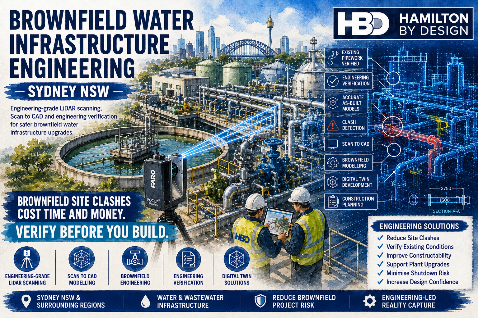
Brownfield engineering projects within smelters are among the most technically challenging industrial projects undertaken in Australia. Unlike greenfield developments, where infrastructure is built on an empty site, brownfield projects require new equipment to be integrated into complex, operating facilities that have often evolved over decades.
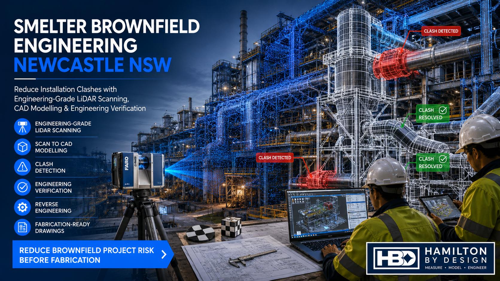
For engineering teams working in Newcastle NSW and throughout the Hunter region, one of the most common and costly problems is discovering during installation that new equipment does not fit the existing plant. Hidden structural steel, undocumented pipework, cable trays, process equipment and access platforms frequently cause clashes that result in expensive rework and extended shutdowns.
At Hamilton By Design, we help reduce these risks by combining engineering-grade LiDAR scanning, Scan to CAD modelling, engineering verification, and detailed mechanical design to ensure every project is based on accurate, up-to-date site information before fabrication begins.
Why Brownfield Engineering Is Different
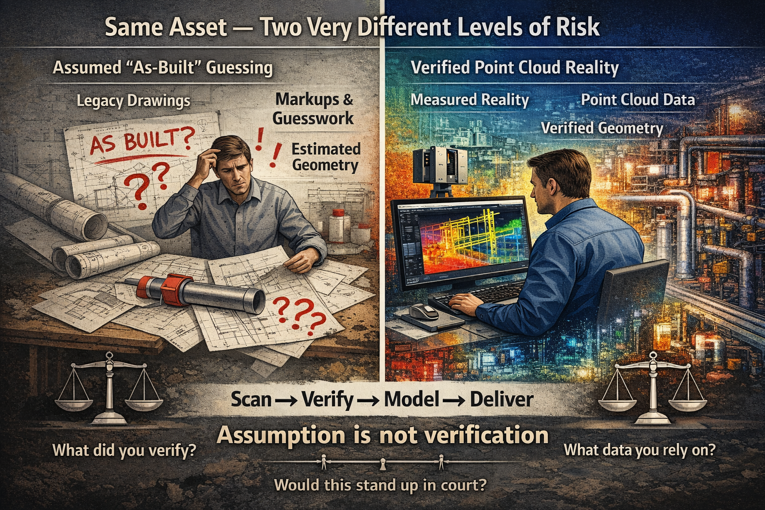
Smelters are continually evolving. New conveyors, upgraded furnaces, replacement ducting, additional pipework and revised process equipment are installed over many years, often without every modification being reflected in the original engineering drawings.
As a result, many facilities have:
- Outdated General Arrangement (GA) drawings
- Missing structural information
- Incomplete pipe routing documentation
- Legacy equipment with no CAD models
- Multiple undocumented modifications
- Limited confidence in existing dimensions
Designing from outdated drawings significantly increases the likelihood of installation problems.
Brownfield engineering begins with understanding the facility exactly as it exists today—not as it was originally designed.
The Biggest Problem: Equipment Clashes During Installation
One of the most expensive discoveries during a shutdown is finding that newly fabricated equipment cannot be installed because it clashes with existing infrastructure.
Common clashes include:
- Structural steel columns and beams
- Existing conveyors
- Pipework and valves
- Dust extraction ducting
- Cable trays
- Walkways and platforms
- Handrails
- Access ladders
- Maintenance clearances
- Crane operating envelopes
Even relatively small clashes can delay installation, requiring emergency redesigns, on-site fabrication, additional welding, crane hire and extended contractor time.
For smelter operators, these delays often translate directly into lost production and increased project costs.
Engineering-Grade LiDAR Scanning
Modern terrestrial LiDAR scanning has transformed how brownfield projects are planned.
Rather than relying solely on tape measures or outdated drawings, millions of highly accurate measurements are captured across the entire facility.
The resulting point cloud provides an engineering-grade digital representation of the plant, allowing designers to work from verified site conditions.
Hamilton By Design delivers registered point cloud datasets suitable for engineering workflows, including:
- E57
- Autodesk ReCap (RCP/RCS)
- LAS
- Engineering coordinate systems where required
These datasets become the foundation for accurate design and verification.
From Point Cloud to Engineering CAD
Capturing the site is only the first step.
Our engineering team converts laser scan data into intelligent CAD models suitable for design, fabrication and construction.
Typical deliverables include:
- Mechanical assemblies
- Structural steel models
- Pipework layouts
- Equipment models
- Access platforms
- Conveyors
- Chutes
- Hoppers
- General Arrangement drawings
- Fabrication drawings
Depending on project requirements, models can be produced using:
- SOLIDWORKS
- Autodesk Inventor
- AutoCAD
- Autodesk Navisworks
- Revit (where BIM integration is required)
These models provide designers with accurate existing conditions before any new equipment is developed.
Engineering Verification Before Fabrication
Perhaps the greatest value in brownfield engineering comes from verifying the proposed design before fabrication begins.
Using the verified point cloud, engineers can overlay new equipment onto the existing facility to ensure:
- Equipment fits correctly
- Pipe routes are achievable
- Structural supports align correctly
- Maintenance access is maintained
- Walkways comply with clearance requirements
- Crane access is available
- Installation sequences are practical
This engineering verification process significantly reduces uncertainty before manufacturing begins.
Clash Detection Saves Time and Money
Once both the existing plant and proposed design are available digitally, clash detection becomes possible.
Instead of discovering problems during installation, potential conflicts are identified during the design phase.
Typical clashes include:
- Pipe-to-pipe interference
- Pipe-to-structure clashes
- Equipment-to-platform conflicts
- Structural steel intersections
- Cable tray interference
- Insufficient maintenance access
- Restricted lifting paths
Resolving these issues digitally is considerably faster and less expensive than making changes during a shutdown.
Supporting Smelter Shutdown Projects
Shutdown windows are often measured in days rather than weeks.
Every hour counts.
Accurate engineering information enables contractors to:
- Fabricate components with confidence
- Minimise on-site modifications
- Reduce hot work
- Improve installation efficiency
- Shorten commissioning time
- Reduce overall shutdown duration
By planning installation around verified site data, projects proceed more smoothly with fewer unexpected issues.
Typical Brownfield Engineering Applications
Hamilton By Design supports a wide range of smelter upgrade projects throughout Newcastle NSW and the Hunter region, including:
- Conveyor upgrades
- Furnace modifications
- Dust extraction systems
- Gas handling upgrades
- Structural strengthening
- Maintenance platform design
- Pipe rerouting
- Equipment replacement
- Pump installations
- Tank modifications
- Material handling systems
- Mechanical plant upgrades
- Process equipment integration
Each project begins with accurate reality capture and ends with engineering documentation suitable for construction.
Why Choose Hamilton By Design?
Hamilton By Design combines practical engineering experience with advanced reality capture technology to deliver solutions tailored to complex industrial environments.
Our services include:
- Engineering-grade terrestrial LiDAR scanning
- Scan to CAD conversion
- Reverse engineering of existing equipment
- Mechanical engineering design
- Structural steel detailing
- Engineering drafting
- 3D CAD modelling
- As-built documentation
- Engineering verification
- Digital asset capture
- Brownfield project support
- Shutdown engineering assistance
Because we are engineers—not simply surveyors or scanning technicians—we understand how captured data is used throughout the engineering design process.
Our workflow is designed to support fabrication, installation and long-term asset management.
Reducing Brownfield Project Risk
Successful brownfield engineering depends on having reliable information before work begins.
Accurate LiDAR scanning, detailed CAD modelling and engineering verification reduce uncertainty, minimise costly installation clashes and improve project outcomes.
For smelter operators in Newcastle NSW, investing in accurate reality capture before fabrication helps avoid shutdown delays, reduces rework, improves safety and provides confidence that new equipment will integrate with the existing facility.
Whether you are replacing a conveyor, upgrading a furnace, installing new process equipment or planning a major brownfield expansion, Hamilton By Design provides the engineering-led reality capture and design services needed to deliver successful outcomes.

Partner with Hamilton By Design
If your next smelter project requires accurate as-built information, engineering-grade LiDAR scanning or detailed Scan to CAD modelling, Hamilton By Design can help.
Our experienced engineering team delivers practical brownfield solutions that reduce installation risk and support efficient project execution across Newcastle, the Hunter region and industrial facilities throughout New South Wales.
From initial site capture through to engineering verification and fabrication-ready documentation, we help ensure your project is built on accurate data—so new equipment fits the first time.
Talk to Us – Contact Us
Our clients: