Industrial projects are often built around a simple assumption:
“The existing drawings are correct.”
Unfortunately, in many industrial facilities that assumption can introduce significant risk.
Mining plants, processing facilities, manufacturing sites, and timber processing operations commonly undergo years or decades of modifications. Equipment changes, structural additions, maintenance alterations, temporary fixes, and undocumented upgrades can gradually move facilities away from their original engineering documentation.
When engineering decisions are based on outdated drawings or manual measurements, project teams may unknowingly introduce safety risks that affect shutdown activities, maintenance work, and plant upgrades.
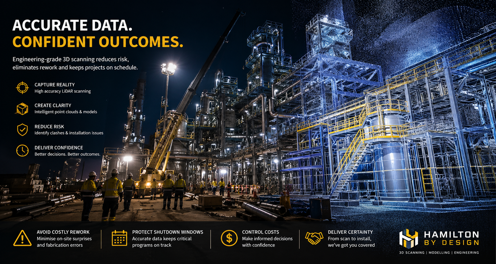
At Hamilton By Design, engineering-grade LiDAR scanning supports safer project outcomes by replacing assumptions with measurable site information.
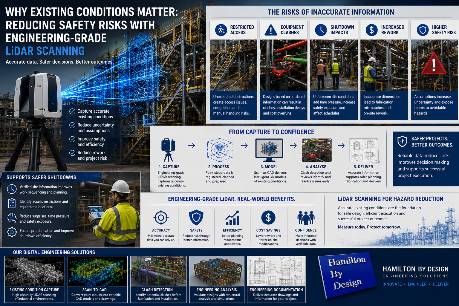
Why Existing Conditions Matter
Existing conditions represent the actual site environment rather than what historical drawings suggest exists.
In industrial environments, discrepancies can develop through:
- Historical modifications
- Unrecorded changes
- Structural alterations
- Equipment replacements
- Temporary repairs becoming permanent solutions
- Missing documentation
- Inaccurate field measurements
A few centimetres of difference can appear minor on a drawing but become significant when:
- Installing new equipment
- Modifying conveyor systems
- Designing platforms
- Routing pipework
- Planning shutdown activities
- Fabricating structural steel
Small errors can create larger project impacts.
Safety Risks Created by Inaccurate Information
Assumptions can introduce several operational and safety challenges.


Examples include:
Restricted Access Areas
Access routes may differ from original layouts, creating:
- Maintenance access issues
- Congestion
- restricted clearances
- Manual handling risks
Equipment Clashes
New designs based on incorrect information may result in:
- Structural clashes
- Pipework interferences
- Equipment conflicts
- Installation delays
Increased Exposure During Shutdown Activities
Shutdown periods often involve:
- Tight schedules
- Multiple work groups
- Limited access windows
- High activity levels
Unexpected site conditions discovered during shutdowns can increase:
- Time pressure
- Additional field modifications
- Safety exposure
- Project costs
Brownfield Projects Present Additional Challenges
Brownfield environments rarely match original design documentation.
Common challenges include:
- Congested plant layouts
- Existing services
- Structural interferences
- Legacy equipment
- Multiple generations of modifications
Designing around assumptions in these environments increases uncertainty.
Existing Condition Capture Using Engineering-Grade LiDAR
Engineering-grade LiDAR scanning captures existing conditions by collecting highly accurate site geometry and generating point cloud data.
Capture can include:
- Structural steel
- Platforms
- Conveyors
- Pipework
- Equipment
- Buildings
- Access systems
- Existing plant layouts
Rather than relying solely on manual measurements, project teams gain access to measurable site information.
Benefits can include:
- Improved accuracy
- Existing condition verification
- Better planning
- Reduced uncertainty
- Reduced installation risk
Clash Detection Before Construction
Once captured, point cloud information can be integrated into engineering workflows.
Scan-to-CAD processes allow:
- Existing condition modelling
- Design development
- Clash detection
- Constructability reviews
- Layout optimisation
Potential problems can be identified before fabrication and site installation begin.
Finding issues digitally generally costs less than discovering them during construction activities.
Supporting Shutdown Planning
Shutdown windows are often measured in hours or days rather than weeks.
Unexpected field discoveries can quickly affect:
- Production schedules
- Labour requirements
- Equipment availability
- Project budgets
LiDAR scanning can support shutdown planning by:
- Capturing actual site conditions
- Identifying access restrictions
- Verifying equipment locations
- Improving work sequencing
- Supporting prefabrication
Better information often leads to more predictable project execution.
Reducing Site Rework
Rework commonly results from:
- Inaccurate dimensions
- Design clashes
- Existing condition errors
- Fabrication mismatches
Reducing rework can improve:
- Safety performance
- Project schedules
- Labour efficiency
- Installation outcomes
- Overall project cost
How Hamilton By Design Supports Safer Industrial Projects
Hamilton By Design combines practical engineering experience with digital engineering workflows to support safer project delivery.
Services can include:
Engineering-Grade LiDAR Scanning
Capture accurate site geometry and existing conditions.
Scan-to-CAD Workflows
Convert point cloud information into:
- Editable CAD models
- Engineering drawings
- Existing condition layouts
Engineering Analysis
Support project decisions through:
- Design validation
- Engineering reviews
- Structural assessment
- Simulation and analysis


Engineering Documentation
Deliver:
- General arrangement drawings
- Fabrication drawings
- Engineering models
- Project information
Moving Beyond Assumptions
Existing conditions influence safety, constructability, and project outcomes.
When projects rely on assumptions rather than measurable information, risks can increase.
Engineering-grade LiDAR scanning helps organisations move from:
Estimated conditions → Verified conditions
The result is improved confidence, reduced risk, safer project execution, and better engineering decisions.