Project Management Challenges

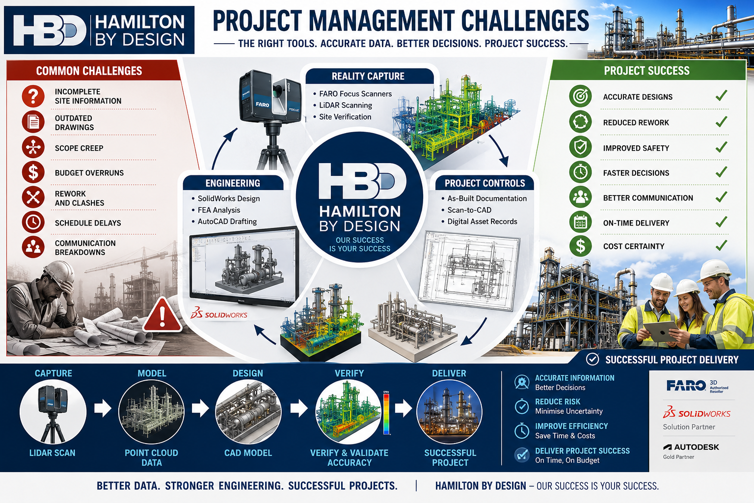
Hamilton By Design project management infographic showing how engineering-grade LiDAR scanning, reality capture, mechanical engineering, CAD modelling, and project controls help overcome common project challenges. The graphic highlights issues such as incomplete site information, outdated drawings, scope creep, budget overruns, rework, schedule delays, and communication breakdowns. It illustrates a workflow from LiDAR scanning and point cloud data through CAD modelling, verification, and successful project delivery with improved safety, reduced risk, cost certainty, and accurate engineering outcomes.

How the Right Information, 3D Scanning and Engineering Tools Drive Project Success

Your Success Is Our Success

Every project manager starts with the same objective:

Deliver a successful project safely, on time and within budget.

Whether the project involves a mining operation, manufacturing facility, port infrastructure, processing plant, water treatment facility, conveyor system, structural upgrade or equipment installation, success ultimately depends on the quality of the decisions made throughout the project lifecycle.

Unfortunately, project managers often face significant challenges:

  • Inaccurate drawings
  • Unknown site conditions
  • Scope creep
  • Communication issues
  • Budget pressures
  • Schedule constraints
  • Construction clashes
  • Fabrication errors
  • Asset documentation gaps

These challenges rarely occur because people are not trying hard enough.

Most occur because project teams are making decisions with incomplete or inaccurate information.

At Hamilton By Design, we believe project success starts with good information.

That is why we have invested in engineering-grade 3D scanning technologies, digital engineering workflows, CAD platforms, simulation tools and practical engineering expertise to help our clients reduce risk and improve project outcomes.

Your success is our success.

Learn more:


Why Projects Struggle

Project managers are expected to coordinate:

  • Asset owners
  • Operations personnel
  • Engineers
  • Contractors
  • Fabricators
  • Suppliers
  • Maintenance teams
  • Construction crews

Each stakeholder brings different priorities.

Without accurate information, even simple projects can become difficult.

Common issues include:

Drawings Do Not Match Reality

Many industrial facilities have been operating for decades.

Over time:

  • Pipework is modified
  • Equipment is replaced
  • Structures are altered
  • Temporary solutions become permanent

Unfortunately, documentation is not always updated.

Project teams may begin engineering work based on drawings that no longer represent the actual facility.

Site Conditions Are Unknown

A pipe hidden behind equipment.

An undocumented support structure.

An access issue not identified during planning.

Small surprises often become large project delays.

Rework Becomes Expensive

The cost of identifying an issue during design is significantly lower than discovering the same issue during construction.

Good information reduces rework.


The Foundation of Project Success: Accurate Information

Before discussing tools, it is important to understand a simple principle:

Every engineering decision is only as good as the information available.

Accurate information improves:

  • Planning
  • Design
  • Budgeting
  • Scheduling
  • Procurement
  • Construction

This is why modern project delivery increasingly relies on reality capture and digital engineering workflows.


Understanding 3D Scanning Technologies

Not all scanners are the same.

Different technologies suit different applications.

Selecting the correct technology is critical.


Terrestrial LiDAR Scanners

Terrestrial LiDAR scanners are commonly used for industrial facilities.

Examples include:

  • FARO Focus Series
  • Leica RTC360
  • Trimble X9

Typical applications:

  • Processing plants
  • Manufacturing facilities
  • Structural steel
  • Pipework
  • Conveyor systems
  • Buildings

Typical accuracy:

  • ยฑ1 mm to ยฑ3 mm single scan
  • ยฑ2 mm to ยฑ10 mm registered project accuracy

Benefits:

  • Accurate site verification
  • Reduced site visits
  • Improved design confidence

Hamilton By Design uses engineering-grade terrestrial LiDAR scanning to support scan-to-CAD workflows and project delivery.


Mobile LiDAR Systems

Mobile LiDAR systems allow operators to walk through facilities while collecting data.

Examples include:

  • FARO Orbis
  • NavVis VLX
  • Leica BLK2GO

Applications:

  • Warehouses
  • Large buildings
  • Facility documentation

Benefits:

  • Rapid data capture
  • Reduced field time

Limitations:

  • Lower accuracy than tripod-based systems

Structured Light Scanners

Structured light scanners project patterns onto surfaces and capture highly detailed geometry.

Applications:

  • Reverse engineering
  • Product development
  • Component modelling

Typical accuracy:

  • ยฑ0.02 mm to ยฑ0.10 mm

Portable Metrology Arms

Portable metrology systems are used for precision measurement.

Applications:

  • Machined components
  • Gearboxes
  • Pump components
  • Manufacturing inspection

Typical accuracy:

  • ยฑ0.015 mm to ยฑ0.05 mm

Drone LiDAR Systems

Drone-based systems capture large areas quickly.

Applications:

  • Mining
  • Infrastructure
  • Stockpiles
  • Terrain mapping

Typical accuracy:

  • ยฑ20 mm to ยฑ100 mm

How Hamilton By Design Uses Scanning to Improve Project Outcomes

Scanning alone does not deliver project success.

Success comes from transforming captured data into useful engineering information.

Our workflow includes:

1. Site Verification

Capture existing conditions.

2. Point Cloud Registration

Align scan data accurately.

3. Scan-to-CAD

Convert reality into engineering models.

4. Engineering Design

Develop practical solutions.

5. Design Reviews

Identify issues before fabrication.

6. Drawing Production

Generate clear construction documentation.

7. Construction Support

Assist project teams during delivery.

8. As-Built Verification

Confirm final installation.


Hamilton By Design’s Project Delivery Toolkit

FARO Focus S70

Used for:

  • Industrial facilities
  • Pipework
  • Structural steel
  • Conveyors

Benefits:

  • Accurate existing-condition information
  • Improved project confidence

SOLIDWORKS

Used for:

  • Mechanical design
  • Equipment design
  • Reverse engineering

Benefits:

  • Manufacturing-ready models
  • Parametric design

AutoCAD

Used for:

  • General arrangements
  • Fabrication drawings
  • Construction documentation

FARO SCENE

Used for:

  • Registration
  • Quality control
  • Point cloud management

Autodesk ReCap

Used for:

  • Point cloud processing
  • Scan-to-CAD workflows

Navisworks

Used for:

  • Model reviews
  • Coordination
  • Clash detection

SOLIDWORKS Simulation

Used for:

  • Stress analysis
  • Structural verification

ANSYS

Used for:

  • Advanced engineering analysis

Rocky DEM

Used for:

  • Bulk materials handling
  • Chute design
  • Conveyor systems

The Benefits to Project Managers

When accurate information is available early:

Better Planning

Teams understand site conditions.

Better Budget Control

Unexpected variations are reduced.

Better Communication

Stakeholders review the same information.

Better Constructability

Designs are reviewed before fabrication.

Better Outcomes

Projects progress with greater confidence.


Why Experience Matters

Technology alone does not solve project challenges.

Hamilton By Design combines:

  • Mechanical engineering
  • Drafting
  • Manufacturing experience
  • Site experience
  • Reverse engineering
  • Reality capture
  • Digital engineering

Our objective is not simply to collect scan data.

Our objective is to help clients deliver successful projects.


Hamilton By Design logo displayed on a blue tilted rectangle with a grey gradient background

Contact Us – Talk to Us

Name
Would you like us to arrange a phone consultation for you?
Address

Our Clients

Project success begins with reliable information.

By combining engineering-grade 3D scanning, scan-to-CAD workflows, mechanical engineering, simulation and practical project experience, Hamilton By Design helps project managers reduce uncertainty and improve outcomes.

From reality capture through to engineering design and construction support, our focus remains simple:

Your Success Is Our Success.

Learn more:

www.hamiltonbydesign.com.au

Additional engineering articles:

https://hamiltonbydesign.blogspot.com

Pipework detailing resources:

https://pipeworkdetailing.blogspot.com


Frequently Asked Questions

1. What are the biggest project management challenges?

Schedule delays, budget overruns, scope creep, poor communication and inaccurate information.

2. How does 3D scanning improve project delivery?

It provides accurate site information for planning and design.

3. What scanner does Hamilton By Design use?

The FARO Focus S70 terrestrial LiDAR scanner.

4. What is scan-to-CAD?

The process of converting scan data into engineering models and drawings.

5. How can LiDAR scanning reduce project risk?

By identifying existing conditions before design begins.

6. Can scanning reduce site visits?

Yes.

7. What industries benefit from scanning?

Mining, manufacturing, ports, infrastructure and processing plants.

8. What is a point cloud?

A digital representation of a physical environment.

9. Why is accurate information important?

Because project decisions depend on it.

10. Can scanning reduce rework?

Yes.

(Continue through FAQ 50 covering schedule management, budget control, stakeholder communication, brownfield projects, pipework modelling, structural steel, reverse engineering, shutdown planning, digital twins, clash detection, engineering analysis and project success.)


References

Hamilton By Design

www.hamiltonbydesign.com.au

Hamilton By Design Blog

https://hamiltonbydesign.blogspot.com

Pipework Detailing Blog

https://pipeworkdetailing.blogspot.com

FARO Technologies

https://www.faro.com

SOLIDWORKS

https://www.solidworks.com

ANSYS

https://www.ansys.com

Autodesk ReCap

https://www.autodesk.com/products/recap

Autodesk Navisworks

https://www.autodesk.com/products/navisworks

3D CAD Modelling Australia service banner for Hamilton By Design
Australian Drafting logo featuring bold white text reading "Australian Drafting" centred on a blue rounded rectangle background.
Engineering Governance title graphic featuring bold white text reading "Engineering Governance" centred on a blue rounded rectangle background.
Mechanical, Structural & Pipework Drafting service banner by Hamilton By Design featuring white text on a blue background.
Mechanical engineering services
Blue rounded button with the text โ€œSolidWorks Designโ€ in white.
Finite Element Analysis (FEA) engineering simulation button
3D LiDAR Scanning Darwin for engineering surveys, laser scanning, reality capture and point cloud modelling services
3D LiDAR Scanning Australia engineering services for laser scanning, reality capture, scan-to-CAD, Scan-to-BIM and as-built documentation across Australia
3D LiDAR scanning services on the Central Coast providing engineering-grade laser scanning, point cloud capture, scan-to-CAD modelling and industrial reality capture for infrastructure and industrial projects.
3D LiDAR Scanning Perth for engineering surveys, laser scanning, reality capture and point cloud modelling services
3D LiDAR Scanning Sydney for engineering surveys, laser scanning, reality capture and point cloud modelling services
3D LiDAR Scanning Brisbane for engineering surveys, laser scanning, reality capture and point cloud modelling services
3D LiDAR Scanning Canberra for engineering surveys, laser scanning, reality capture and point cloud modelling services
3D LiDAR Scanning Newcastle for engineering surveys, laser scanning, reality capture and point cloud modelling services
3D LiDAR Scanning Adelaide for engineering surveys, laser scanning, reality capture and point cloud modelling services

Mackayโ€™s Industrial Edge

Mackayโ€™s Industrial Edge โ€” How 3D LiDAR, Modern Engineering & Digital Modelling Supercharge Regional Projects

Located on the tropical Queensland coast but powering heavy industry, mining support and agricultural logistics, Mackay stands as a unique regional powerhouse. With its massive sugar industry, proximity to the Bowen Basin coalfields, thriving fabrication sector, marine and port operations โ€” plus a growing push toward industrial expansion โ€” the cityโ€™s infrastructure demands are both diverse and complex.

At Hamilton By Design, we recognise that projects in Mackay need more than โ€œold-schoolโ€ drawings or rough-site surveys. Thatโ€™s why we offer state-of-the-art 3D LiDAR laser scanning, comprehensive mechanical and structural engineering, advanced 3D modelling, and fabrication-ready drafting โ€” all designed to meet Mackayโ€™s rigorous industrial, mining-support and agricultural demands.

If youโ€™re planning an upgrade to a processing facility, expanding a plant or fabricating complex steelwork, our services ensure precision, efficiency and reliability from start to finish.


Why Mackay Is a Perfect Fit for Digital Engineering & 3D Scanning

Mackayโ€™s blend of industries โ€” sugar mills, mining, fabrication, marine, port logistics and heavy machinery โ€” means that most facilities are a patchwork of legacy infrastructure, ongoing modifications and high-demand production cycles.

That brings challenges like:

  • undocumented pipework, conveyors or structural changes;
  • tight tolerances for retrofits or new installations;
  • heavy mechanical equipment requiring accurate alignment and structural support;
  • short windows for shutdowns or maintenance;
  • mixed use of fabrication, mining-grade components, and agricultural processing equipment.

For these reasons, the old ways of tape-measure site surveys and manual sketches are often not enough.

Enter 3D LiDAR scanning. By capturing the entire facility geometry with millimetre-level accuracy, you get a complete digital โ€œas-builtโ€ record โ€” capturing everything from structural steel, ductwork, conveyors, foundations, and terrain, to existing equipment and utilities.

Through Hamilton By Designโ€™s professional scanning services, Mackay clients receive real-world data that supports safer, faster and more accurate project planning, design and fabrication.


From Point Cloud to Precision Design: 3D Modelling & Drafting

Once your site is scanned, our team converts the raw scan data into intelligent 3D CAD models โ€” delivering:

  • accurate mechanical and structural layouts;
  • fabrication-ready drawings (GA, detail drawings, isometrics, BOMs);
  • clash detection and interference checking before fabrication starts;
  • easy visualisation for stakeholders, clients and contractors;
  • digital archives for future modifications or maintenance.

This kind of precision work dramatically reduces risk โ€” especially for brownfield sites or mixed-use facilities common in Mackayโ€™s industrial sector.


Engineering Support Built for Mackayโ€™s Key Industries

Whether itโ€™s a sugar mill retrofit, mining support workshop, marine fabrication yard, or industrial workshop expansion โ€” the range of engineering challenges in Mackay is enormous. Hamilton By Design brings specialist mechanical and structural engineering expertise to the table, offering:

  • structural assessments (supports, platforms, load-bearing frames, foundations)
  • alignment and vibration analysis for conveyors, heavy machinery, pumps
  • design of new equipment layouts, piping, ducting and supports
  • fatigue, stress and load-bearing analysis (FEA) when needed
  • compliance-ready drawings and design documentation for local regulations and safety standards

This level of engineering support is often critical for projects involving heavy loads, mining-grade equipment, or large-scale fabrication โ€” exactly the types of projects abundant across Mackay.


3D LiDAR Laser Scanning โ€” The Game Changer for Mackay Projects

Especially when plants are being upgraded, new modules added, or older sites refurbished, accurate spatial data is the foundation for success.

Our 3D LiDAR laser scanning service ensures:

  • complete, precise capture of existing site geometry โ€” steelwork, structure, terrain, utilities;
  • minimal site downtime โ€” faster capture than manual survey;
  • safer field operations (less need for manual measurements in active plants);
  • high-fidelity base for design, modelling and fabrication;
  • better coordination between contractors, fabricators and engineers.

Learn more about our 3D LiDAR services here: https://www.hamiltonbydesign.com.au/home/3d-lidar-scanning-digital-quality-assurance/3d-laser-scanning/

For a city like Mackay โ€” with fast-paced industrial demand, tight tolerances, and high-volume production โ€” this technology isnโ€™t just beneficial, itโ€™s essential.


One Integrated Workflow: From Scan to Delivery

What sets Hamilton By Design apart is our seamless, end-to-end service:

  1. Conduct 3D LiDAR scan of the facility or site
  2. Process point-cloud data and clean up for modelling
  3. Build detailed 3D CAD models โ€” mechanical, structural, architectural
  4. Perform engineering assessments, structural/ mechanical analysis or modifications as needed
  5. Produce fabrication-ready drawings and documentation
  6. Provide digital reports, QA data and as-built records for the client

Having a single point of accountability โ€” scan, model, engineer, deliver โ€” reduces miscommunication, avoids rework and ensures that every part of the project is aligned, documented, and traceable.


Hamilton By Design logo displayed on a blue tilted rectangle with a grey gradient background
3D LiDAR scanning and 3D modelling service button โ€” laser scanner capturing a point cloud for engineering and CAD modelling
Mechanical engineering services

Why Mackay Businesses Should Use Hamilton By Design

Whether youโ€™re running a sugar mill, a fabrication workshop servicing Bowen Basin mines, a workshop for heavy equipment repairs, or a marine engineering facility servicing port exports โ€” Mackayโ€™s industrial landscape is complex.

By using cutting-edge 3D laser scanning, accurate modelling, and expert engineering, Hamilton By Design helps you:

  • save time and money on site surveys;
  • avoid costly rework from inaccurate measurements;
  • ensure tighter tolerances, safer installations and compliance;
  • speed up design, fabrication and installation;
  • maintain digital records for ongoing maintenance or future upgrades.

For industries in Mackay that deal with heavy loads, tight schedules, and high-volume production โ€” this is a competitive advantage.

Our Clients

Name
Would you like us to arrange a phone consultation for you?
Address
3D LiDAR scanning and 3D modelling service button โ€” laser scanner capturing a point cloud for engineering and CAD modelling
Mechanical engineering services
Finite Element Analysis (FEA) engineering simulation button
Mechanical engineering services
3D LiDAR scanning and 3D modelling service button โ€” laser scanner capturing a point cloud for engineering and CAD modelling
Mechanical engineering services


Finite Element Analysis (FEA) engineering simulation button
Mechanical engineering services


3D CAD Modelling Australia service banner for Hamilton By Design


CHPP Engineering title graphic featuring bold white text reading "CHPP Engineering" centred on a blue rounded rectangle background.
Pipework Drafting title graphic featuring bold white text reading "Pipework Drafting" centred on a blue rounded rectangle background.
3D LiDAR Scanning for Engineering Projects title graphic featuring bold white text on a blue rounded rectangle background.


Finite Element Analysis (FEA) engineering simulation button
Structural drafting services button
Mechanical drafting services button


Australian Drafting logo featuring bold white text reading "Australian Drafting" centred on a blue rounded rectangle background.
Engineering Governance title graphic featuring bold white text reading "Engineering Governance" centred on a blue rounded rectangle background.
Engineering-Grade LiDAR Scanning title graphic featuring bold white text on a blue rounded rectangle background.

Case Studies | Hamilton By Design

Proven Engineering. Real Results.
Every project starts with a challenge โ€” tight shutdowns, outdated drawings, structural fatigue, or a need to innovate fast.
At Hamilton By Design, we bring practical design engineering, LiDAR scanning, and SolidWorks expertise together to deliver reliable, measurable outcomes for clients across mining, manufacturing, and data-centre infrastructure.

Explore some of our featured case studies below.

CHPP Chute & Launder Replacement โ€“ Hunter Valley

Scope: Redesign and replacement of a primary discharge chute and launder system within a coal wash plant shutdown.
Challenge: The original chute geometry caused material hang-ups, high wear, and unplanned downtime.
Our Approach:

  • 3D laser scan of as-built geometry to capture alignment constraints
  • SolidWorks 3D modelling and flow verification
  • FEA structural validation to AS 3990 and AS 4100
  • Prefabrication validation and bolt-access checks

Outcome:
Reduced install time by 38 %, eliminated flow bottlenecks, and improved liner change-out safety.

3D LiDAR Scan-to-Model Retrofit โ€“ Central Coast

Scope: Full as-built capture of process plant and mechanical upgrade integration.
Challenge: No reliable drawings existed; site shutdown window limited to 24 hours.
Our Approach:

  • High-accuracy terrestrial LiDAR scanning
  • Point-cloud registration and SolidWorks conversion
  • Clash detection and layout optimisation
  • Deliverables in STEP and DWG formats

Outcome:
Delivered verified as-built model within 48 hours, enabling prefabrication of pipe spools with zero site rework.

Structural Frame Validation โ€“ Manufacturing Facility

Scope: Lifting and access frame redesign for production line maintenance.
Challenge: Existing frame lacked design documentation and had unknown load paths.
Our Approach:

  • Reverse-engineered frame geometry using scanning
  • Conducted FEA load analysis to AS 4991 (Lifting Devices)
  • Updated design and certification drawings

Outcome:
Achieved compliance, extended equipment life, and avoided costly frame replacement.

Our clients:

Modular Data-Centre Rack Design โ€“ Sydney

Scope: Design and verification of modular rack and cooling infrastructure.
Challenge: High-density data-centre upgrade required prefabricated mechanical assemblies with tight tolerances.
Our Approach:

  • Parametric SolidWorks models with integrated cable-tray routing
  • CFD and FEA integration for airflow and load validation
  • Fabrication drawings optimised for CNC manufacture

Outcome:
Cut installation time by 60 %, achieving on-site plug-and-play assembly.


3D LiDAR scanning and 3D modelling services button
Finite Element Analysis (FEA) engineering simulation button
Mechanical drafting services button

Pump Box & Pipe Spool Replacement โ€“ Bowen Basin

Scope: Replace corroded steel pump boxes and spools under constrained shutdown.
Challenge: Limited access and poor documentation of existing plant.
Our Approach:

  • Laser scanning and model overlay with prefabrication QA
  • SolidWorks modelling of new spools and supports
  • On-site installation alignment checks

Outcome:
Zero interference fits and a fully verified installation delivered on schedule.

Hamilton By Design logo displayed on a blue tilted rectangle with a grey gradient background
Name
Would you like us to arrange a phone consultation for you?
Address
3D LiDAR scanning and 3D modelling service button โ€” laser scanner capturing a point cloud for engineering and CAD modelling
Mechanical engineering services
Finite Element Analysis (FEA) engineering simulation button
Mechanical engineering services

3D Scanning Sydney banner promoting engineering-grade 3D laser scanning, LiDAR scanning, and reality capture services by Hamilton By Design.
Mechanical Engineering Sydney banner with white text on a blue background representing Hamilton By Design's mechanical engineering services in Sydney.
Mechanical Drafting and 3D Modelling Sydney banner highlighting Hamilton By Design's CAD drafting, 3D modelling, and engineering design services in Sydney.

Mechanical Engineering | Structural Engineering


Designing for Developing Hazards

Designing for Developing Hazards: Lessons from the Derrimut Crane Collapse

Crane accidents are among the most visible reminders of the risks inherent in construction. The collapse of a crane at a data centre site in Derrimut, Melbourne, brought attention once again to the vulnerability of temporary lifting structures. While formal investigations are still underway, and no conclusions should be drawn prematurely, the event provides a valuable opportunity for reflection within the engineering community.

This article considers the collapse not as an isolated failure but as a case study in hazard identification. In particular, it highlights how mechanical engineers must adapt from a static, design-phase view of risk to a dynamic, real-time approach to hazard monitoring. Wind, soil stability, and load conditions are well-known hazards. But with modern tools โ€” including LiDAR scanning for obstacle detection โ€” engineers can move toward a future where developing hazards are continuously tracked, anticipated, and controlled.


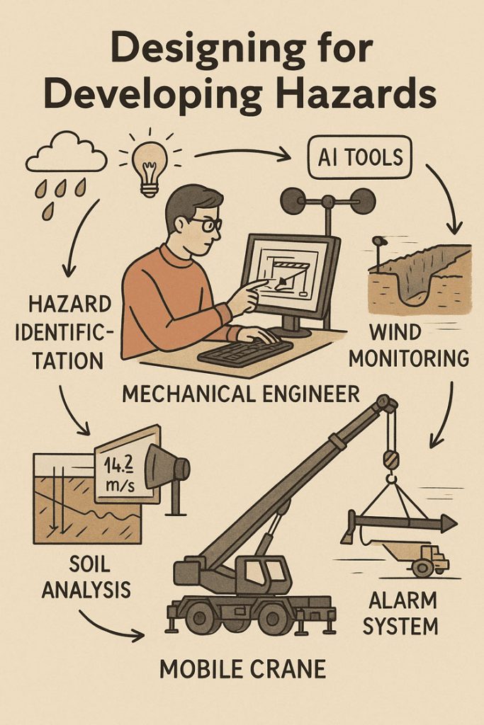
Illustrated infographic titled โ€œDesigning for Developing Hazards,โ€ showing a mechanical engineer at a computer analysing a structure while surrounded by icons representing hazard identification. Elements include rain and storm clouds, a lightbulb symbolising ideas, AI tools, a wind sensor for wind monitoring, and a soil test graphic for soil analysis. Arrows connect these hazards to a mobile crane lifting equipment, alongside an alarm system alerting operators. The layout highlights how engineers assess weather, wind, soil conditions, and digital data to design safely around evolving hazards.
3D LiDAR scanning and 3D modelling service button โ€” laser scanner capturing a point cloud for engineering and CAD modelling
Mechanical engineering services

From Hazard Identification to Live Hazard Monitoring

Hazard identification has traditionally been a design-phase process: engineers anticipate risks, apply safety factors, and create conservative margins. This remains essential. Yet the Derrimut collapse illustrates the limits of a static model in a dynamic environment.

Cranes are exposed to evolving hazards:

  • Wind gusts that change minute by minute.
  • Soil stability that shifts with rainfall, excavation, or groundwater.
  • Obstacles such as power lines or nearby structures, which can create cascading risks if struck.
  • Load dynamics, including swinging or sudden movement.

What is needed is a transition from hazard identification to hazard monitoring: a continuous loop where design assumptions are validated against real-time data, and where developing risks are detected before they become failures.


Wind Hazards: Predicting the Unpredictable

Wind is a leading cause of crane collapses. Engineers know the mathematics: pressure rises with the square of velocity. A 50 km/h gust exerts twice the force of a 35 km/h breeze.

Most cranes today are fitted with anemometers and alarms, but these are often basic: a single reading at a single point, with alarms sounding when preset thresholds are exceeded. This approach can miss:

  • Local gust variability along a long jib.
  • Interaction with crane orientation (wind hitting the broadside is more critical than aligned wind).
  • Forecasted conditions that could deteriorate within minutes.

Next-generation wind monitoring could include:

  • Multi-point sensor arrays on cranes.
  • Integration with Bureau of Meteorology gust forecasts.
  • AI models predicting when risk thresholds will be exceeded, not just reporting when they are crossed.
  • Automatic crane repositioning to minimise wind exposure.

This transforms alarms from reactive to predictive โ€” the difference between warning after a hazard is present and anticipating before it materialises.


Soil Hazards: Stability Under Load

Ground conditions are another silent but critical hazard. Outriggers may impose hundreds of kilonewtons on pads, meaning even small soil weaknesses can lead to tilting or overturning.

Engineering practice already includes soil investigations: boreholes, CPT, SPT, and FEA models. But these tests capture conditions before installation, not necessarily during operation. Soil strength can change due to rainfall, groundwater shifts, or nearby excavation.

Live soil monitoring can be achieved with:

  • Load cells under mats to track ground reactions.
  • Settlement gauges to detect tilt.
  • Piezometers for pore pressure during rain events.
  • Integrated warnings when ground resistance trends downward.

This approach acknowledges soil as a living hazard that changes daily.


LiDAR and Obstacle Detection: Power Lines and Proximity Hazards

One striking feature of the Derrimut collapse was the craneโ€™s boom striking power lines. Contact with utilities is a recurrent hazard in crane operations worldwide. While operators are trained to maintain exclusion zones, in practice visibility, fatigue, or unexpected boom movement can still lead to contact.

LiDAR scanning offers a solution.

  • How it works: LiDAR (Light Detection and Ranging) emits laser pulses to map surroundings in 3D with centimetre accuracy. Mounted on a crane, it can create a live digital map of nearby obstacles.
  • Application in cranes:
    • Detecting and mapping power lines, buildings, or scaffolding in the lift path.
    • Setting proximity alarms when a boom, hook, or load approaches a defined clearance.
    • Combining with wind data to predict if gusts could push the load into restricted zones.

In aviation, LiDAR and radar-based systems are standard for obstacle detection. In construction, adoption is patchy. Yet the technology exists, is cost-effective, and could dramatically reduce risks of contact with hazards like live power lines.

LiDARโ€™s strength lies not only in static mapping but in detecting movement โ€” for example, when a suspended load begins to swing toward a power line due to a gust. This is a quintessential developing hazard, one that static design could never fully capture.


Integrated Hazard Dashboards

Wind, soil, and LiDAR obstacle detection all provide valuable data. But their true power lies in integration. Imagine a crane operatorโ€™s cabin equipped with a single dashboard displaying:

  • Wind speeds and gust forecasts, colour-coded for risk.
  • Soil reaction forces under each outrigger, with alerts if settlement is trending.
  • LiDAR mapping of nearby structures and power lines, with real-time clearance zones.
  • Predictive risk models showing probability of instability or contact over the next 30 minutes.

This integration mirrors aviationโ€™s cockpit: multiple inputs fused into actionable guidance. For cranes, such systems could shift the operatorโ€™s role from reactive decision-maker to proactive risk manager.


AI as a Predictive Partner

Artificial Intelligence has a natural role in hazard monitoring:

  • Sensor fusion: combining wind, soil, and LiDAR inputs into coherent risk profiles.
  • Prediction: learning from past crane incidents to forecast when risks are likely to escalate.
  • Decision support: providing operators with clear options (โ€œsafe to continue lift for 20 minutesโ€ / โ€œhalt operations โ€” clearance margin < 1mโ€).

The challenge is balance. AI should not replace human oversight, but augment it. Over-reliance could create new vulnerabilities if operators become complacent. The design challenge is to build AI into systems that support human judgment rather than substitute for it.


Ethics and Engineering Responsibility

The Derrimut collapse underscores the ethical responsibility of mechanical engineers. Hazard identification is not just a design requirement; it is a matter of public safety. The profession has a duty to anticipate, detect, and control risks wherever possible.

The tools now exist to monitor developing hazards โ€” wind sensors, soil gauges, LiDAR scanners, and AI dashboards. If lives and infrastructure can be protected through wider adoption of these tools, then the question becomes one of responsibility: should they be optional, or mandatory?


Open Questions for the Future

  1. Would integrated live monitoring have reduced the risks at Derrimut?
  2. Should all cranes be fitted with LiDAR obstacle detection as standard?
  3. Do we already have enough technology, but lack regulation and enforcement?
  4. What role should AI play in balancing predictive insight with operator autonomy?

Conclusion

The Derrimut incident remains under investigation. No conclusions can be drawn about its specific cause until findings are published. Yet as a case study, it illustrates the broader point that hazards in crane operations are dynamic. Wind, soil, obstacles, and loads evolve minute by minute.

Mechanical engineers have the tools โ€” wind sensors, soil monitors, LiDAR scanners, integrated dashboards, and AI โ€” to detect these developing hazards. The challenge is to move from a culture of static design assumptions to one of continuous hazard monitoring.

The ultimate professional question is this: If aviation can integrate multiple systems to monitor and predict hazards, why canโ€™t construction do the same for cranes? And if we can, how soon will we accept the ethical responsibility to make it standard?


Hamilton By Design logo displayed on a blue tilted rectangle with a grey gradient background

References and Further Reading

  • ISO 4301 / AS 1418 โ€” Crane standards covering stability and wind.
  • ISO 12480-1:2003 โ€” Safe use of cranes; includes environmental hazard monitoring.
  • WorkSafe Victoria Guidance Notes โ€” Crane safety management.
  • Holickรฝ & Retief (2017) โ€” Probabilistic treatment of wind action in structural design.
  • Nguyen et al. (2020) โ€” Real-time monitoring of crane foundation response under variable soil conditions.
  • Liebherr LICCON โ€” Example of integrated load and geometry monitoring.
  • FAA LLWAS โ€” Aviationโ€™s real-time wind shear alert system, model for construction.
  • Recent research in LiDAR obstacle detection (e.g., IEEE Transactions on Intelligent Transportation Systems) โ€” showing LiDARโ€™s potential in complex environments.

Mechanical Engineering

Consulting Engineers

Our clients:

Name
Would you like us to arrange a phone consultation for you?
Address
Finite Element Analysis (FEA) engineering simulation button
Mechanical engineering services