3D Laser Scanning Chatswood | North Shore

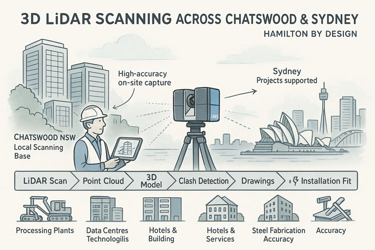
Infographic promoting 3D LiDAR scanning across Chatswood and Sydney, showing a technician operating a laser scanner with Sydney landmarks in the background. The graphic highlights services such as point clouds, 3D modelling, clash detection, drawings and installation fit, with icons representing processing plants, data centres, hotels, buildings, steel fabrication and accuracy.

3D LiDAR Scanning in Chatswood and Sydneyโ€™s North Shore

Hamilton By Design provides high-accuracy 3D LiDAR laser scanning and drafting services for projects across Chatswood, the Lower North Shore and greater Sydney.

Blue 3D LiDAR scanner icon on a tripod with scanning waves

Whether youโ€™re refurbishing an office floor, upgrading a plant room, planning a hotel fit-out or redeveloping an older building, we capture millimetre-accurate as-built data so your team can design with confidence and avoid costly rework on site.


Why 3D LiDAR Scanning for Sydney Projects?

Many Sydney buildings and industrial sites have been modified over decades. Original drawings are incomplete, out of date, or simply wrong. Tape measures and rough sketches arenโ€™t enough when youโ€™re trying to:

  • Fit new services into congested ceiling voids
  • Install new equipment into tight plant rooms
  • Convert offices, retail or hotels to new uses
  • Upgrade mechanical, electrical or hydraulic systems

Our 3D LiDAR scanning captures millions of data points to create an accurate digital twin of your site. This becomes the single source of truth for architects, engineers, builders and fabricators.


3D LiDAR scanning and 3D modelling service button โ€” laser scanner capturing a point cloud for engineering and CAD modelling
Mechanical engineering services

Who We Work With in Chatswood & Greater Sydney

We support a wide range of clients, including:

  • Architects & building designers โ€“ renovation, fit-out and adaptive-reuse projects
  • Property developers & commercial building owners โ€“ feasibility, refurbishment and change-of-use
  • Builders, shop-fitters & interior fit-out contractors โ€“ offices, retail, hospitality and medical suites
  • Industrial & manufacturing facilities โ€“ plant rooms, processing areas, warehouses and workshops
  • Hotel & hospitality operators โ€“ refurbishing guest rooms, lobbies and back-of-house areas
  • Consulting engineers, BIM and drafting teams โ€“ needing reliable as-built data to design from
  • Strata managers & property managers โ€“ accurate base drawings for long-term building management

From Chatswood, North Sydney and Macquarie Park through to the Sydney CBD, Parramatta and wider metropolitan region, we bring the same engineering-grade accuracy to every project.


Our 3D Scanning & Drafting Services

3D LiDAR Laser Scanning

  • On-site 3D LiDAR scanning of buildings, plant rooms, industrial areas and external structures
  • Safe, non-intrusive data capture with minimal disruption to tenants or operations
  • High-resolution point clouds suitable for detailed engineering and architectural design

As-Built Documentation & Point Cloud Deliverables

  • Cleaned and registered point clouds supplied in industry-standard formats
  • 2D plans, sections and elevations derived from the scan
  • As-built drawings for compliance, approvals and record documentation

3D Modelling & Drafting

  • 3D models developed in professional CAD platforms (e.g. SolidWorks and other CAD tools)
  • Structural steel, mechanical plant, pipework and platforms modelled directly from scan data
  • General arrangement drawings, details and DXF files ready for fabrication

Coordination, Clash Checks & Fit-Out Support

  • Model overlays for new works versus existing conditions
  • Early identification of clashes in ceilings, risers and plant rooms
  • Support for coordination meetings between architects, engineers and builders

Typical Projects in Chatswood & Sydney

  • Office and commercial fit-outs in Chatswoodโ€™s commercial towers
  • Refurbishment of aged office buildings into modern workplaces or mixed-use spaces
  • Plant-room upgrades for HVAC, fire, electrical and data infrastructure
  • Retail, hospitality and hotel refurbishments needing accurate existing conditions
  • Layout and expansion projects in industrial estates and light-manufacturing facilities

In each case, our role is to give your team accurate 3D project data so design, pricing and construction decisions are based on reality, not assumptions.


Hamilton By Design provides engineering-led 3D scanning, LiDAR scanning, mechanical engineering and digital engineering services throughout Sydney and Greater Sydney.

Explore our related Sydney services:


  • 3D Scanning Sydney โ€“ Engineering-grade terrestrial laser scanning, as-built surveys and point cloud capture for industrial, infrastructure and commercial projects.
  • Reality Capture Sydney โ€“ High-accuracy reality capture, digital twins, asset documentation and engineering-grade site verification.
  • Scan to CAD Sydney โ€“ Convert point cloud data into AutoCAD, SolidWorks, Inventor and other engineering-ready CAD deliverables.
  • Point Cloud Modelling Sydney โ€“ Engineering-grade point cloud processing, clash detection, as-built verification and 3D modelling.
  • Mechanical Engineering Sydney โ€“ Mechanical design, plant upgrades, materials handling systems, conveyors, chutes, platforms and engineering support.
  • Structural Drafting Sydney โ€“ Structural steel drafting, fabrication drawings, GA drawings, workshop detailing and as-built documentation.

Hamilton By Design supports projects throughout Sydney CBD, Parramatta, Liverpool, Penrith, Blacktown, Chatswood, Alexandria, Mascot, Newcastle and the Central Coast.


Why Work With Hamilton By Design?

  • Mechanical engineering background โ€“ not just survey data, but practical design insight
  • Millimetre-accurate capture for reliable as-built documentation
  • Drafting and design capability โ€“ from point cloud to fabrication-ready drawings
  • Local knowledge of Chatswood and the broader Sydney construction and industrial environment
  • Flexible engagement โ€“ from one-off scans to full scan-to-model-to-fabrication workflows

Letโ€™s Talk About Your Chatswood or Sydney Project

If youโ€™re planning a refurbishment, fit-out or plant upgrade in Chatswood or greater Sydney, accurate 3D data is the simplest way to reduce risk, avoid clashes and keep your project on schedule.

Get in touch with Hamilton By Design to discuss:

  • Your site and project objectives
  • What needs to be scanned
  • The outputs your designers, engineers or fabricators require

Weโ€™ll recommend a practical scanning and drafting scope that fits your budget and timeframes while giving your team the confidence that comes from working with trusted, verified as-built information.


Hamilton By Design logo displayed on a blue tilted rectangle with a grey gradient background
3D LiDAR scanning and 3D modelling service button โ€” laser scanner capturing a point cloud for engineering and CAD modelling
Mechanical engineering services

Lessons from a Landmark Case

Blue banner graphic displaying the text "Point Cloud to CAD - Australia" in large white lettering, representing point cloud processing, scan-to-CAD conversion and digital engineering services across Australia.
Blue banner graphic displaying the text "Scan to CAD Sydney" in large white lettering, representing engineering-led point cloud to CAD conversion, LiDAR scanning and digital engineering services in Sydney.
Blue banner graphic displaying the text "Reality Capture Sydney - CBD" in large white lettering, representing engineering-led reality capture, LiDAR scanning and digital engineering services within Sydney CBD commercial buildings and infrastructure.

How 3D Laser Scanning Supports As-Built Documentation Under Australian Building Codes & Legal Requirements

Accuracy of 3D LiDAR Scanning With FARO

Engineering Services

Our clients

Name
Would you like us to arrange a phone consultation for you?
Address
3D Scanning Sydney banner promoting engineering-grade 3D laser scanning, LiDAR scanning, and reality capture services by Hamilton By Design.
Mechanical Engineering Sydney banner with white text on a blue background representing Hamilton By Design's mechanical engineering services in Sydney.
Mechanical Drafting and 3D Modelling Sydney banner highlighting Hamilton By Design's CAD drafting, 3D modelling, and engineering design services in Sydney.


3D Scanning Sydney


3D Scanning Sydney banner promoting engineering-grade 3D laser scanning, LiDAR scanning, and reality capture services by Hamilton By Design.
Mechanical Engineering Sydney banner with white text on a blue background representing Hamilton By Design's mechanical engineering services in Sydney.
Mechanical Drafting and 3D Modelling Sydney banner highlighting Hamilton By Design's CAD drafting, 3D modelling, and engineering design services in Sydney.

Mechanical Engineering | Structural Engineering


3D Scanning outside of Australia

3D Scanning outside of Australia

In todayโ€™s fast-moving construction, infrastructure and industrial-upgrade sectors โ€” whether in Europe, Asia, North America, Africa or South America โ€” reality is rarely simple. Projects are large, environments complex, and legacy structures old or undocumented. Thatโ€™s where 3D scanning (or 3D LiDAR scanning) becomes a game-changer.

With modern 3D scanning services, you can capture an entire site, plant, asset or building โ€” every surface, every pipe run, every structural detail โ€” in accurate digital form. Traditional measuring tools (tape measures, laser meters, manual surveying) are still useful. But on large or congested sites, or when you donโ€™t have safe access everywhere, manual methods can be slow, error-prone, and often incomplete.

By contrast, 3D scanning uses laser-based (or LiDAR-based) measurements to gather millions of data points quickly and remotely. The result is a dense โ€œpoint cloudโ€ โ€” a highly detailed and accurate 3D snapshot of reality.

3D LiDAR scanning and 3D modelling service button โ€” laser scanner capturing a point cloud for engineering and CAD modelling
Mechanical engineering services

Why 3D Scanning Works โ€” No Matter Where You Are

Hereโ€™s why 3D scanning works so well globally:

  • Speed and Efficiency: A detailed 3D scan that might take days or weeks with traditional survey methods can often be completed in hours. That means faster project starts, shorter downtime, and less disruption.
  • Safety: Because the scan can be done remotely (laser pulses travel to surfaces without the need for physical access), itโ€™s ideal for hazardous zones, tight spaces, or unstable structures.
  • Full Context: Unlike isolated point measurements, 3D scanning captures full spatial context โ€” geometry, dimensions, relationships between elements and spatial orientation. This is invaluable for retrofit design, expansions, refurbishments, or structural assessments.
  • As-Built Accuracy: For heritage buildings, older industrial plants, or legacy infrastructure โ€” where existing drawings may be outdated or missing โ€” 3D scanning provides a reliable, accurate โ€œas-builtโ€ record. Great for restoration, renovation, maintenance, or future planning.
  • Reduced Errors & Rework: Because your base designs, additions, installations or repairs on real-world data, the risk of clashes, misfits, or unexpected surprises drops dramatically โ€” which saves time and money downstream.

Where 3D Scanning Is Already Making a Difference Globally

Across the world, 3D scanning is being used in a range of industries and projects โ€” and its benefits scale with scope and complexity. Some examples:

  • Industrial plants and processing facilities โ€” mapping existing installations for maintenance, retrofits or expansions
  • Construction and infrastructure โ€” buildings, bridges, tunnels, utilities, and structural inspections
  • Heritage and restoration projects โ€” capturing intricate architectural details of historical buildings or monuments without physical contact
  • Manufacturing, factories and heavy industry โ€” reverse engineering, component inspection, machinery layout, and plant upgrades
  • Survey, mapping and urban planning โ€” terrain, topography, urban structures, utilities and civil works

Because 3D scanning is not location-specific, firms and clients worldwide โ€” regardless of local regulations or industry sector โ€” can leverage its advantages.

What Makes a 3D Scanning Service Valuable โ€” Anywhere

If youโ€™re looking to engage a 3D scanning service outside Australia, hereโ€™s what you should check to get the most value:

  • Use of current, high-resolution scanners (LiDAR or equivalent 3D scanning technology), able to generate dense point clouds with millimetre-level detail.
  • Skilled operators who understand not only how to capture data, but how to process it. Raw scans need thoughtful post-processing, registration, and sometimes CAD/BIM conversion to be truly useful.
  • Delivery of actionable, usable outputs โ€” not just raw point clouds. That means as-built models, CAD drawings, BIM-ready files or structural drawings depending on the project.
  • Clear scope definition: What you need โ€” renovation planning, plant upgrade, heritage restoration, clash detection, quality control โ€” and an understanding of what a scan can and cannot do.
  • Flexibility to work in different environments โ€” industrial sites, confined spaces, heritage structures, remote locations.

Why You Should Consider 3D Scanning for Your Next Project

Whether youโ€™re managing a factory upgrade, planning a structural refurbishment, restoring a heritage building, or designing a new facility โ€” 3D scanning gives you clarity. It removes guesswork. It captures reality, not drawings.

In many global markets today, the pressure for speed, accuracy, and cost-effectiveness is growing. Regulations, safety standards, environmental concerns and complexity of infrastructure demand better data โ€” and 3D scanning delivers.

If you havenโ€™t tried 3D scanning yet, or if youโ€™re depending on old drawings or manual survey methods, now may be the time to reconsider. The technology โ€” and the workflow โ€” has matured, and the benefits are real: faster turnarounds, safer operations, clearer documentation, and fewer surprises.

For engineers, architects, contractors, heritage specialists, surveyors and project managers around the world โ€” adopting 3D scanning could be the most efficient way to ensure project success.

Hamilton By Design logo displayed on a blue tilted rectangle with a grey gradient background
3D LiDAR scanning and 3D modelling service button โ€” laser scanner capturing a point cloud for engineering and CAD modelling
Mechanical engineering services
Name
Address
You would like to:

3D Laser Scanning

3D LiDAR Scanning โ€“ Digital Quality Assurance

3D Scanning for Construction

Transforming Projects with 3D Scanning


3D Scanning Sydney banner promoting engineering-grade 3D laser scanning, LiDAR scanning, and reality capture services by Hamilton By Design.
Mechanical Engineering Sydney banner with white text on a blue background representing Hamilton By Design's mechanical engineering services in Sydney.
Mechanical Drafting and 3D Modelling Sydney banner highlighting Hamilton By Design's CAD drafting, 3D modelling, and engineering design services in Sydney.

Mechanical Engineering | Structural Engineering


The Real-World Accuracy of 3D LiDAR Scanning With FARO S150 & S350 Scanners

When people first explore 3D LiDAR scanning, one of the most eye-catching numbers in any product brochure is the advertised accuracy. FAROโ€™s Focus S150 and S350 scanners are often promoted as delivering โ€œยฑ1 mm accuracy,โ€ which sounds definitive and easy to rely on for engineering, mining and fabrication work. But anyone who has spent time working with 3D LiDAR scanning in real industrial environments understands that accuracy isnโ€™t a single number โ€” it is a system of interrelated factors.

This article explains what the ยฑ1 mm specification from FARO really means, how accuracy shifts with distance, and what engineers, project managers and clients need to do to achieve dependable results when applying 3D LiDAR scanning on live sites.
3D LiDAR scanning and 3D modelling service button โ€” laser scanner capturing a point cloud for engineering and CAD modelling
Mechanical engineering services

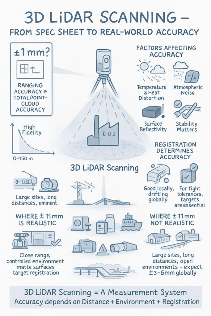
Infographic explaining 3D LiDAR scanning accuracy, showing a scanner capturing a building and highlighting factors that affect accuracy such as temperature, atmospheric noise, surface reflectivity and tripod stability. Includes diagrams comparing realistic versus unrealistic ยฑ1 mm accuracy, the impact of distance, environment and registration quality, and notes that large open sites typically achieve ยฑ3โ€“6 mm global accuracy.

1. What FAROโ€™s โ€œยฑ1 mm Accuracyโ€ Really Means in 3D LiDAR Scanning

The ยฑ1 mm number applies only to the internal distance measurement unit inside the scanner. It reflects how accurately the laser measures a single distance in controlled conditions.

It does not guarantee:

  • ยฑ1 mm for every point in a full plant model
  • ยฑ1 mm for every dimension extracted for engineering
  • ยฑ1 mm global accuracy across large multi-scan datasets

In 3D LiDAR scanning, ranging accuracy is just one ingredient. Real-world accuracy is shaped by distance, reflectivity, scan geometry and how multiple scans are registered together.


2. How Accuracy Changes With Distance in Real Projects

Even though the S150 and S350 list the same ranging accuracy, their 3D LiDAR scanning performance changes as distance increases. This is due to beam divergence, angular error, environment and surface reflectivity.

Typical real-world behaviour:

  • 0โ€“10 m: extremely precise, often sub-millimetre
  • 10โ€“25 m: excellent for engineering work, only slight noise increase
  • 25โ€“50 m: more noticeable noise and increasing angular error
  • 50โ€“100 m: atmospheric distortion and reduced overlap become evident
  • Near maximum range: still useful for mapping conveyors, yards and structures, but not suitable for tight fabrication tolerances

This distance-based behaviour is one of the most important truths to understand about 3D LiDAR scanning in field conditions.


3. Ranging Accuracy vs Positional Accuracy vs Global Accuracy

Anyone planning a project involving 3D LiDAR scanning must distinguish between:

Ranging Accuracy

The ยฑ1 mm value โ€” only the distance measurement.

3D Positional Accuracy

The true X/Y/Z location of a point relative to the scanner.

Global Point Cloud Accuracy

How accurate the entire dataset is after registration.

Global accuracy is the number engineers depend on, and it is normally around ยฑ3โ€“6 mm for large industrial sites โ€” completely normal for terrestrial 3D LiDAR scanning.


4. What Real Field Testing Reveals About FARO S-Series Accuracy

Independent practitioners across mining, infrastructure, CHPPs, plants and structural environments report similar results when validating 3D LiDAR scanning against survey control:

  • ยฑ2โ€“3 mm accuracy in compact plant rooms
  • ยฑ5โ€“10 mm across large facilities
  • Greater drift across long, open, feature-poor areas

These outcomes are not equipment faults โ€” they are the natural result of how 3D LiDAR scanning behaves in open, uncontrolled outdoor environments.


5. Why Registration Matters More Than the Scanner Model

Most real-world error in 3D LiDAR scanning comes from registration, not the laser itself.

Cloud-to-Cloud Registration

Good for dense areas, less reliable for long straight conveyors, open yards or tanks.

Target-Based Registration

Essential for high-precision engineering work.
Allows tie-in to survey control and dramatically improves global accuracy.

If your project needs ยฑ2โ€“3 mm globally, target control is mandatory in all 3D LiDAR scanning workflows.


6. Surface Reflectivity and Environmental Effects

Reflectivity dramatically affects measurement quality during 3D LiDAR scanning:

  • Matte steel and concrete return excellent data
  • Rusted surfaces return good data
  • Dark rubber, black plastics and wet surfaces reduce accuracy
  • Stainless steel and glass behave unpredictably

Environmental factors โ€” wind, heat shimmer, dust, rain โ€” also reduce accuracy. Early morning or late afternoon typically produce better 3D LiDAR scanning results on mining and industrial sites.


7. When ยฑ1 mm Is Actually Achievable

True ยฑ1 mm accuracy in 3D LiDAR scanning is realistic when:

  • Working within 10โ€“15 m
  • Surfaces are matte and reflective
  • Registration uses targets
  • Tripod stability is high
  • Conditions are controlled

This makes it suitable for:

  • Pump rooms
  • Valve skids
  • Structural baseplates
  • Reverse engineering
  • Small mechanical upgrades

But achieving ยฑ1 mm across a full plant, CHPP, or yard is outside the capability of any terrestrial 3D LiDAR scanning workflow.


8. S150 vs S350: Which One for Your Accuracy Needs?

S150 โ€“ Engineering-Focused Precision

Ideal for industrial rooms, skids, structural steel and retrofit design work where short-to-mid-range accuracy is essential.

S350 โ€“ Large-Area Coverage

Perfect for conveyors, rail lines, yards, and outdoor infrastructure.
Global accuracy must be survey-controlled for tight tolerances.

Both scanners deliver excellent 3D LiDAR scanning performance, but the S150 is the engineering favourite while the S350 is the large-site specialist.


9. What to Specify in Contracts to Avoid Misunderstandings

Instead of stating:

โ€œScanner accuracy ยฑ1 mm.โ€

Specify:

  • Local accuracy requirement (e.g., ยฑ2 mm at 15 m)
  • Global accuracy requirement (e.g., ยฑ5 mm total dataset)
  • Registration method (mandatory target control)
  • Environmental constraints

  • Verification method (e.g., independent survey checks)

This ensures everyone understands what 3D LiDAR scanning will realistically deliver.


10. When a Terrestrial Scanner Is Not Enough

Do not rely solely on 3D LiDAR scanning for:

  • Machine alignment <1 mm
  • Bearing or gearbox placement
  • Certified dimensional inspection
  • Metrology-level tolerances

In these cases, supplement scanning with:

  • Laser trackers
  • Total stations
  • Metrology arms
  • Hybrid workflows

Conclusion: The Real Truth About 3D LiDAR Scanning Accuracy

FAROโ€™s S150 and S350 are outstanding tools for industrial 3D LiDAR scanning, but the ยฑ1 mm spec does not tell the full story. Real-world accuracy is a combination of:

  • Distance
  • Registration method
  • Surface reflectivity
  • Site conditions
  • Workflow discipline

When used correctly, these scanners consistently deliver high-quality, engineering-grade point clouds suitable for clash detection, retrofit design, fabrication planning and as-built documentation.

3D LiDAR scanning is not just a laser โ€” it is an entire measurement system.
And when the system is applied with care, it produces reliable, repeatable data that reduces rework, improves safety, and strengthens decision-making across mining, construction, fabrication and industrial operations.

Where Is your project

3D Scanning Sydney CBD3D Scanning Brisbane CBD
3D Scanning across Melbourne3D Scanning across Perth
3D Scanning across Adelaide3D Scanning in The Hunter Valley
3D Scanning Mount Isa3D Scanning Emerald
3D Laser Scanning Central Coast3D Scanning in The Pilbara
3d Scanning other Areas of Australia3D Scanning Outside Australia
Hamilton By Design logo displayed on a blue tilted rectangle with a grey gradient background
3D LiDAR scanning and 3D modelling service button โ€” laser scanner capturing a point cloud for engineering and CAD modelling
Mechanical engineering services
Name
Address
You would like to:

3D CAD Modelling | 3D Scanning

Mechanical Engineering Perth WA banner for Hamilton By Design featuring white text on a blue background.
3D Laser Scanning Perth WA banner for Hamilton By Design with white text on a blue background.
SolidWorks Perth WA banner for Hamilton By Design featuring white text on a blue background.

3D Experience Platform Login

3D Scanning for Construction

Transforming Projects with 3D Scanning

3D LiDAR Scanning โ€“ Digital Quality Assurance

https://www.hamiltonbydesign.com.au/perth-wa
3D CAD Modelling Australia service banner for Hamilton By Design
3D LiDAR scanning and 3D modelling service button โ€” laser scanner capturing a point cloud for engineering and CAD modelling
Mechanical engineering services

3D CAD Modelling Australia service banner for Hamilton By Design
Mechanical, Structural & Pipework Drafting service banner by Hamilton By Design featuring white text on a blue background.
Australian Drafting logo featuring bold white text reading "Australian Drafting" centred on a blue rounded rectangle background.
Blue banner graphic displaying the text "Point Cloud to CAD - Australia" in large white lettering, representing point cloud processing, scan-to-CAD conversion and digital engineering services across Australia.
CHPP Engineering title graphic featuring bold white text reading "CHPP Engineering" centred on a blue rounded rectangle background.
Engineering Governance title graphic featuring bold white text reading "Engineering Governance" centred on a blue rounded rectangle background.
Mechanical engineering services
Australian Drafting logo featuring bold white text reading "Australian Drafting" centred on a blue rounded rectangle background.
3D LiDAR Scanning Hunter & Newcastle banner with white text on a blue background promoting engineering-grade laser scanning services for industrial, mining and infrastructure projects across the Hunter Valley and Newcastle region.
Mechanical Engineering Hunter & Newcastle banner promoting mechanical engineering services for mining, industrial plants, power generation, manufacturing and heavy industry throughout the Hunter Valley and Newcastle region.
Structural Drafting Hunter & Newcastle banner promoting structural drafting services for mining, industrial plants, power generation, manufacturing and infrastructure projects across the Hunter Valley and Newcastle region.
Mechanical Engineering Perth WA banner for Hamilton By Design featuring white text on a blue background.
3D Laser Scanning Perth WA banner for Hamilton By Design with white text on a blue background.
SolidWorks Perth WA banner for Hamilton By Design featuring white text on a blue background.
Fabrication and product design services
Finite Element Analysis (FEA) engineering simulation button
3D LiDAR scanning and 3D modelling service button โ€” laser scanner capturing a point cloud for engineering and CAD modelling
Blue rounded button with the text โ€œSolidWorks Designโ€ in white.
Mechanical drafting services button
Structural drafting services button

3D Scanning Sydney banner promoting engineering-grade 3D laser scanning, LiDAR scanning, and reality capture services by Hamilton By Design.
Mechanical Engineering Sydney banner with white text on a blue background representing Hamilton By Design's mechanical engineering services in Sydney.
Mechanical Drafting and 3D Modelling Sydney banner highlighting Hamilton By Design's CAD drafting, 3D modelling, and engineering design services in Sydney.

Mechanical Engineering | Structural Engineering


3D Laser Scanning in the Pilbara

High-Accuracy LiDAR Capture for Iron Ore, Mining, Processing & Heavy Industrial Projects

The Pilbara is one of the toughest and most productive mining regions in the world โ€” from major iron-ore operations to heavy material-handling infrastructure, port facilities and processing plants. Hamilton By Design provides high-accuracy 3D laser scanning across the Pilbara, delivering millimetre-accurate digital data to support engineering upgrades, shutdowns, maintenance and compliance.

Whether you operate a mine site, rail facility, conveyor system, crusher station, transfer tower or port infrastructure, 3D scanning provides a true digital record of your assets โ€” eliminating guesswork and reducing downtime during critical works.


3D LiDAR scanning and 3D modelling service button โ€” laser scanner capturing a point cloud for engineering and CAD modelling
Mechanical engineering services

Why 3D Scanning is Essential in the Pilbara

Mining infrastructure in the Pilbara runs 24/7 under intense wear, high temperatures and long production cycles.
Manual measurements and tape-based methods simply cannot meet the accuracy or safety requirements of modern mining operations.

Common tape-measure problems in Pilbara operations:

  • Misaligned holes, flanges or bolt patterns
  • Spools or structural components that donโ€™t fit during shutdown
  • Incorrect angles, offsets or clearances
  • Rework and cutting/grinding onsite
  • Cost blowouts due to unexpected geometry
  • Lost shutdown hours due to re-fabrication
  • Safety risks from working at heights or near live plant

3D scanning removes these risks entirely by capturing exact as-built geometry, even in complex or harsh industrial environments.


Hamilton By Designโ€™s 3D Scanning Capabilities in the Pilbara

We use high-accuracy FARO LiDAR scanners and advanced modelling workflows to support engineering teams, fabricators and shutdowns across the region.

As-Built Laser Scanning

Capture the true geometry of:

  • ROM pads & crusher stations
  • Overland conveyors & transfer towers
  • Screen houses
  • Car dumpers
  • Stackers & reclaimers
  • Rail loadout facilities
  • Pump skids & pipe spools
  • Drive stations & take-up systems
  • Port handling systems
  • Structural platforms, stairs & gantries

Perfect for refurbishments, shutdown planning and large brownfield upgrades.

Scan-to-CAD Modelling

From your scans we can produce:

  • SolidWorks models
  • GA drawings
  • Fabrication-ready component models
  • Clash detection models (Navisworks)
  • Digital twins
  • BIM-ready geometry
  • Pipe spools, chutes, frames & mechanical layouts

Accurate, fabrication-ready models reduce installation risk to nearly zero.

Shutdown & Maintenance Support

3D scanning helps Pilbara teams:

  • Verify replacement components before dispatch
  • Capture worn equipment for reverse engineering
  • Ensure new equipment fits existing frames
  • Confirm bolt centres, flange faces & alignment
  • Reduce onsite cutting, grinding & modification
  • Complete shutdowns faster and safer

Digital QA & Dimensional Verification

Before components leave a workshop, we can:

  • Scan the fabricated item
  • Overlay it against the original CAD
  • Validate dimensional accuracy
  • Confirm a perfect onsite fit

This prevents shutdown-day surprises.


Industries & Operations We Support in the Pilbara

Hamilton By Design provides scanning and engineering support to:

  • Iron ore operations
  • Port stockyard & ship-loading infrastructure
  • Screening & crushing plants
  • Conveyor and transfer systems
  • Rail loadout facilities
  • Pumping & dewatering infrastructure
  • Fabrication workshops & OEM suppliers
  • Shutdown and maintenance contractors
  • Structural & mechanical engineering teams

If it moves ore, loads ore, screens ore or supports ore โ€” we can scan it.


Benefits of 3D Scanning for Pilbara Mining Operations

1. Fit-Right-First-Time Fabrication

No more rework, cutting, grinding or on-the-fly adjustments.

2. Millimetre-Accurate Digital Capture

Every measurement is accurate โ€” bolt holes, beam centres, flanges, angles, offsets and clearances.

3. Increased Safety

Scanning is done from the ground, reducing time spent working at heights or near live machinery.

4. Reduced Shutdown Duration

Upgrades install faster when parts actually fit.

5. Better Communication

3D models and point clouds clearly communicate constraints and layout to all stakeholders.

6. Future-Proof Documentation

Your digital twin becomes a long-term asset for planning future works.


Why Choose Hamilton By Design in the Pilbara?

  • Experience scanning iron-ore operations, heavy plant and brownfield facilities
  • Precise, fabrication-ready modelling using SolidWorks & 3DEXPERIENCE
  • Fast mobilisation to Pilbara sites
  • Strong understanding of shutdown pressures and operational constraints
  • Clear, clean, professional deliverables for fabricators & engineers
  • Digital QA & verification before dispatch
  • Practical, hands-on engineering knowledge โ€” not just scanning technology

We partner with mine operators, engineering teams, supervisors, fabricators and shutdown contractors to keep projects accurate, predictable and on schedule.


Book 3D Laser Scanning in the Pilbara

If your operation requires precise site data for a shutdown, upgrade, conveyor modification, structural redesign or new fabrication, Hamilton By Design can deliver fast, reliable and accurate 3D scanning anywhere in the Pilbara.

Hamilton By Design logo displayed on a blue tilted rectangle with a grey gradient background
3D LiDAR scanning and 3D modelling service button โ€” laser scanner capturing a point cloud for engineering and CAD modelling
Mechanical engineering services

Contact us today to book a scan or request a project review.

Name
Address
You would like to:

Enhancing Plant Efficiency with Best Maintenance Practices

3D CAD Modelling Australia service banner for Hamilton By Design
Australian Drafting logo featuring bold white text reading "Australian Drafting" centred on a blue rounded rectangle background.
Engineering Governance title graphic featuring bold white text reading "Engineering Governance" centred on a blue rounded rectangle background.
Mechanical, Structural & Pipework Drafting service banner by Hamilton By Design featuring white text on a blue background.
Mechanical engineering services
Blue rounded button with the text โ€œSolidWorks Designโ€ in white.
Finite Element Analysis (FEA) engineering simulation button
3D LiDAR Scanning Darwin for engineering surveys, laser scanning, reality capture and point cloud modelling services
3D LiDAR Scanning Australia engineering services for laser scanning, reality capture, scan-to-CAD, Scan-to-BIM and as-built documentation across Australia
3D LiDAR scanning services on the Central Coast providing engineering-grade laser scanning, point cloud capture, scan-to-CAD modelling and industrial reality capture for infrastructure and industrial projects.
3D LiDAR Scanning Perth for engineering surveys, laser scanning, reality capture and point cloud modelling services
3D LiDAR Scanning Sydney for engineering surveys, laser scanning, reality capture and point cloud modelling services
3D LiDAR Scanning Brisbane for engineering surveys, laser scanning, reality capture and point cloud modelling services
3D LiDAR Scanning Canberra for engineering surveys, laser scanning, reality capture and point cloud modelling services
3D LiDAR Scanning Newcastle for engineering surveys, laser scanning, reality capture and point cloud modelling services
3D LiDAR Scanning Adelaide for engineering surveys, laser scanning, reality capture and point cloud modelling services

Engineering Projects

3D Point Clouds Are a Game-Changer for Your Projects

Your Experts in 3D Laser Scanning & Mechanical Design

3D CAD Modelling | 3D Scanning

3D Laser Scanning in Emerald

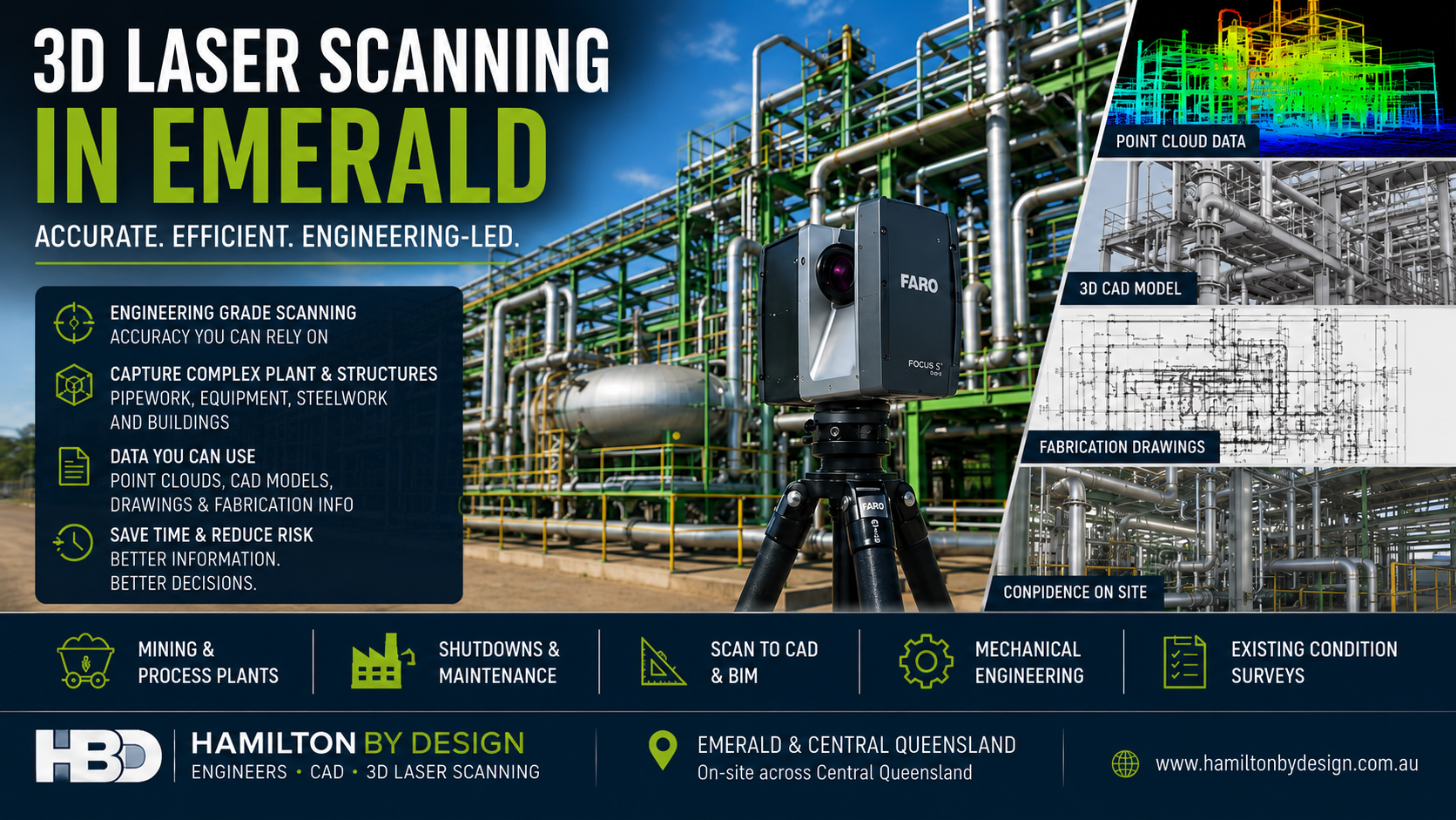
3D laser scanning in Emerald Queensland showing industrial plant, LiDAR point cloud data, CAD modelling and engineering drawings

High-Accuracy As-Built Capture for CHPP Wash Plants, Coal Handling & Heavy Industry

Emerald and the Bowen Basin are home to some of Queenslandโ€™s busiest and most demanding coal-handling and processing facilities. With aging infrastructure, tight shutdown windows, and constant production pressures, accurate site information is critical.

Hamilton By Design provides precise 3D laser scanning to CHPP wash plants, prep plants, conveyors, transfer towers, pump stations, structural frames and pipe networks throughout Emerald and the surrounding mining regions.

Our goal is simple:
Eliminate tape-measure guesswork and deliver millimetre-accurate, fabrication-ready data for every upgrade, repair and shutdown.


3D LiDAR scanning and 3D modelling service button โ€” laser scanner capturing a point cloud for engineering and CAD modelling
Mechanical engineering services

Why CHPP Wash Plants in Emerald Need 3D Laser Scanning

CHPP facilities are complex, congested and constantly changing. When engineers or contractors rely on tape measures, handwritten notes or rough sketches, the risk of error is extremely high.

This often leads to:

  • Components not fitting during installation
  • Bolts or flange centres misaligned
  • Pipes being the wrong length
  • Chutes or liners fouling on existing steelwork
  • Rework during shutdowns
  • Lost production hours
  • Costly on-site modifications by fitters and boilermakers

In coal processing, even small dimensional errors quickly become big operational headaches.

3D laser scanning removes these risks entirely.


The Problems With Tape-Measure Field Measurement

Traditional measurement methods struggle in CHPP environments:

1. Human Error

Heat, dust, noise, confined spaces and poor visibility create inaccuracies.

2. Inconsistent Reference Points

Different people measure from different spots โ€” results vary every time.

3. No True Geometry Capture

Angles, offsets, diagonals and complex mating surfaces are almost impossible to measure with a tape.

4. Difficult or Unsafe Access

Platforms, hoppers, overhead conveyors, vibrating screens and sumps often require working at heights or around operational machinery.

5. No Digital Record

Paper notes get lost, damaged, or misinterpreted.
3D scanning gives you a permanent digital asset.

The result?
Tape measurements introduce errors so large they can jeopardise an entire shutdown.


How 3D Laser Scanning Solves These Problems

Hamilton By Design uses high-accuracy FARO Focus LiDAR scanners to capture millions of real-world points in minutes.

Benefits for CHPP and Coal Handling Facilities

  • Millimetre-level accuracy of all structures, machinery, and clearances
  • Capture large areas quickly โ€” even during partial operation
  • Improved safety โ€” most scanning is done from the ground
  • True geometry of chutes, screens, pumps, frames and conveyors
  • Reduced shutdown time by ensuring parts fit the first time
  • Perfect data for reverse engineering and redesign
  • Digital twins for planning future upgrades
  • Better contractor communication using real 3D models
  • No need to revisit site to re-measure

The scan becomes your โ€œsource of truthโ€ for all engineering decisions.


Applications of 3D Scanning in Emerald CHPP & Coal Handling

Chute, Hopper & Diverter Redesign

Capture accurate geometry of wear areas, impact zones and constrained spaces.

Conveyor & Transfer Tower Upgrades

Scan head pulleys, take-ups, guards, floors, beams, stringers and chutes.

Pipe Spools & Pump Stations

Produce correct spool lengths, flange positions and alignment geometry.

Structural Platforms & Walkways

Verify fitment before steel fabrication.

Screen & Crusher Areas

Capture high-vibration, difficult-to-access zones safely.

Shutdown Planning & Digital QA

Scan new components before shipping and confirm exact fit before installation.


Scan-to-CAD for Engineering & Fabrication

Your scanned site can be converted into:

  • SolidWorks 3D models
  • Fabrication-ready drawings
  • Layout & GA models
  • BOMs and take-offs
  • Navisworks models for clash detection
  • Digital twins for future maintenance

No more โ€œhope it fitsโ€ โ€” we deliver data you can trust.


Why Mining Companies in Emerald Choose Hamilton By Design

  • Deep experience with CHPP wash plants, conveyors and coal handling systems
  • Rapid mobilisation to Emerald and Bowen Basin sites
  • Precise, millimetre-accurate digital capture
  • Clean, fabrication-ready models for contractors and workshops
  • Reduced shutdown risk and rework
  • Practical engineering knowledge, not just scanning technology
  • 3D scanning + mechanical/structural engineering under one roof

We work with maintenance crews, shutdown coordinators, engineering managers, fabricators and OEM suppliers to ensure every upgrade, repair or replacement fits perfectly the first time.


Book 3D Laser Scanning in Emerald

If your CHPP or coal handling operation needs accurate measurement for a chute redesign, conveyor upgrade, pump station modification or shutdown preparation, Hamilton By Design is ready to deliver fast, precise and safe 3D scanning support.

Hamilton By Design logo displayed on a blue tilted rectangle with a grey gradient background
3D LiDAR scanning and 3D modelling service button โ€” laser scanner capturing a point cloud for engineering and CAD modelling
Mechanical engineering services

Book a scan today or request a free project review.

Name
Address
You would like to:

3D Point Clouds Are a Game-Changer for Your Projects

Your Experts in 3D Laser Scanning & Mechanical Design

3D CAD Modelling | 3D Scanning

3D Experience Platform Login

3D CAD Modelling | 3D Scanning

3D CAD Modelling Australia service banner for Hamilton By Design
Australian Drafting logo featuring bold white text reading "Australian Drafting" centred on a blue rounded rectangle background.
Engineering Governance title graphic featuring bold white text reading "Engineering Governance" centred on a blue rounded rectangle background.
Mechanical, Structural & Pipework Drafting service banner by Hamilton By Design featuring white text on a blue background.
Mechanical engineering services
Blue rounded button with the text โ€œSolidWorks Designโ€ in white.
Finite Element Analysis (FEA) engineering simulation button
3D LiDAR Scanning Darwin for engineering surveys, laser scanning, reality capture and point cloud modelling services
3D LiDAR Scanning Australia engineering services for laser scanning, reality capture, scan-to-CAD, Scan-to-BIM and as-built documentation across Australia
3D LiDAR scanning services on the Central Coast providing engineering-grade laser scanning, point cloud capture, scan-to-CAD modelling and industrial reality capture for infrastructure and industrial projects.
3D LiDAR Scanning Perth for engineering surveys, laser scanning, reality capture and point cloud modelling services
3D LiDAR Scanning Sydney for engineering surveys, laser scanning, reality capture and point cloud modelling services
3D LiDAR Scanning Brisbane for engineering surveys, laser scanning, reality capture and point cloud modelling services
3D LiDAR Scanning Canberra for engineering surveys, laser scanning, reality capture and point cloud modelling services
3D LiDAR Scanning Newcastle for engineering surveys, laser scanning, reality capture and point cloud modelling services
3D LiDAR Scanning Adelaide for engineering surveys, laser scanning, reality capture and point cloud modelling services

How 3D Laser Scanning Supports As-Built Documentation Under Australian Building Codes & Legal Requirements

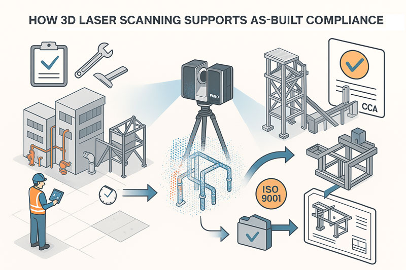
illustration of 3d scanning and building code of australia

1. What the Building Code of Australia (BCA) and Australian Standards Require

While the BCA (part of the National Construction Code โ€“ NCC) does not mandate 3D laser scanning, it does mandate that:

You must provide accurate, verifiable as-built documentation, including:

  • As-built drawings reflecting what was actually constructed
  • Evidence that construction aligns with design intent and approvals
  • Documentation for certification, compliance, commissioning and future maintenance

These requirements flow through:

  • NCC Volume 1 โ€“ Construction documentation, fire systems, mechanical services
  • AS 1100 โ€“ Technical drawing standards
  • AS 5488 โ€“ Subsurface utility information
  • AS 9001/ISO 9001 โ€“ Quality management documentation
  • State-based WHS / Plant Safety legislation
  • Engineering registration Acts (NSW, QLD, VIC)
  • Client-specific QA frameworks (e.g., TfNSW Digital Engineering, mining compliance standards, government project handover requirements)

These frameworks all emphasise accuracy, traceability, verification and record-keeping.


2. Common Problems with Traditional As-Built Documentation

Most non-compliance issues in handover packages arise because traditional methods rely on:

  • Manual tape measurements
  • Incomplete mark-ups on outdated drawings
  • Limited site access
  • Errors stacking up across multiple trades
  • No accurate record of clashes and deviations
  • No evidence trail for certifiers

This often results in:

  • Disputes between builders, certifiers and subcontractors
  • Rework costs during commissioning
  • Safety risks due to undocumented services or variations
  • Delays in obtaining Occupation Certificates (OC)

3. How 3D Laser Scanning Directly Supports Legal & BCA/NCC Compliance

โœ” 3D Scanning Provides โ€œVerified As-Constructed Evidenceโ€

Point clouds record geometry with millimetreโ€“level accuracy, giving:

  • Audit-proof evidence of what exists
  • Time-stamped scanning sessions
  • A defensible digital record for certifiers, engineers and auditors

This is extremely helpful for:

  • Compliance sign-off
  • Dispute resolution
  • Safety compliance
  • Future upgrades or modifications

โœ” Produces Accurate As-Built Drawings That Meet AS 1100 Requirements

Laser scanning allows you to generate:

  • Certified 2D as-built drawings
  • 3D models
  • Fabrication-ready details
  • Clash-free spatial coordination drawings

This ensures:

  • Dimensions are correct
  • Penetrations, fall directions, service locations and structural offsets are true to field conditions
  • All documentation aligns with NCC-required accuracy

โœ” Eliminates Measurement Errors That Could Breach Compliance

Regulators and certifiers need as-built documents to match constructed work.

Laser scanning:

  • Removes subjective tape measurements
  • Captures difficult/unsafe areas safely
  • Ensures penetrations, ductwork, pipe routes and tolerances match required clearances
  • Supports inspections under NCC (fire, structural, mechanical, accessibility, plant rooms, etc.)

โœ” Simplifies BCA Documentation for Fire, Mechanical & Structural Systems

Scanning assists with validating:

Fire Safety Systems

  • Hydrants, hose reels, fire pump rooms
  • Fire damper locations
  • Egress paths and spatial compliance
  • Service penetrations

Mechanical Systems

  • Duct routes
  • Plant room layouts
  • Fan coil units / AHU placement
  • Shaft centre-lines
  • Compliant access paths

Structural Elements

  • Columns
  • Beams
  • Brackets
  • Plant mounts
  • Retrofitted steelwork
  • Tolerance checks

The point cloud provides certifiers with confidence that what was installed does not deviate from approved plans beyond allowable tolerances.


โœ” Strengthens ISO 9001 & Government QA Requirements

Most government tenders (TfNSW, Defence, Health Infrastructure, QBuild, etc.) require:

  • Traceable QA
  • As-constructed verification
  • Digital documentation

A 3D scan becomes proof of measurement, improving your QA process by providing:

  • Verifiable dimensional control
  • Pre-fabrication QA
  • Handover packages that exceed minimum compliance

4. How Hamilton By Design Can Position This Service

3D Laser Scanning Enables:

  • NCC-compliant as-built documentation
  • Faster certifier approval
  • Fewer construction disputes
  • Reduced rework during commissioning
  • Better safety compliance
  • Accurate digital twins for maintenance and lifecycle management

You can state (truthfully):

โ€œOur 3D scans provide defensible, audit-ready as-built records that satisfy NCC, engineering, and certification requirements. Certifiers appreciate the precision because it removes ambiguity and reduces approval delays.โ€


Hamilton By Design logo displayed on a blue tilted rectangle with a grey gradient background

Why Shutdown Parts Donโ€™t Fit

Finite Element Analysis (FEA) engineering simulation button
Mechanical engineering services

Accuracy of 3D LiDAR Scanning With FARO

Mechanical Engineering | Structural Engineering

Mechanical Drafting | Structural Drafting

3D CAD Modelling | 3D Scanning

Chute Design