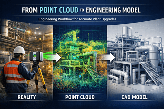
From Point Cloud to Engineering Model Workflow

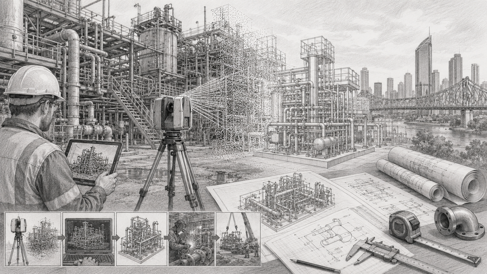
Engineering workflow showing industrial laser scanning, point cloud data, and a CAD model used for plant upgrade design.

Modern industrial facilitiesโ€”especially in mining, processing plants, and heavy infrastructureโ€”are complex environments where accurate site information is essential. Before engineers can design upgrades, modifications, or shutdown works, they must understand exactly what exists in the field today.

This is where the point cloud to engineering model workflow becomes critical.

Using engineering-grade 3D laser scanning, engineers can capture millions of spatial measurements in minutes, creating a highly accurate digital representation of existing plant conditions. These measurements form what is known as a point cloud, which becomes the foundation for accurate CAD models, engineering design, and upgrade planning.

Hamilton By Design specialises in this process through engineering-grade reality capture and modelling services across mining and industrial facilities.

Learn more about our scanning services here:
https://www.hamiltonbydesign.com.au/home/engineering-grade-3d-laser-scanning-mining-industrial/
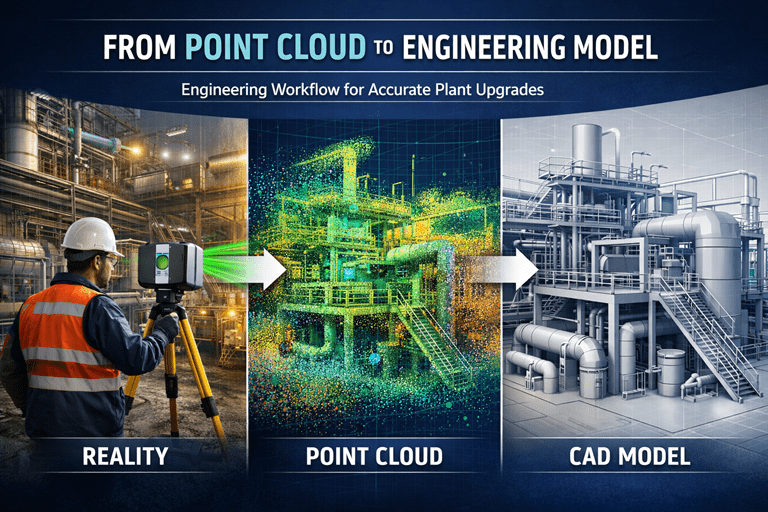

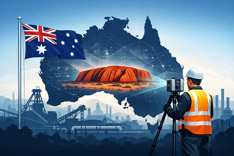
Engineer using a laser scanner capturing an industrial facility, converting scan data into a point cloud and engineering CAD model.

What is a Point Cloud?

A point cloud is a dense collection of spatial coordinates captured by a 3D laser scanner. Each point represents a precise location on a surface such as steelwork, piping, equipment, or structures.

Modern scanners can capture millions of points per second, creating a digital snapshot of the real environment with millimetre-level accuracy.

Once captured, the point cloud becomes the digital foundation used by engineers to reconstruct existing plant geometry.


3D LiDAR scanning and 3D modelling service button โ€” laser scanner capturing a point cloud for engineering and CAD modelling
Mechanical engineering services

Hamilton By Design logo displayed on a blue tilted rectangle with a grey gradient background

The Point Cloud to Engineering Model Workflow

Turning raw scan data into usable engineering information involves several structured steps.

1. Project Planning and Site Preparation

Before scanning begins, engineers define:

  • Required accuracy
  • Project scope
  • Areas to be captured
  • Level of modelling detail required

This ensures the captured data supports downstream engineering tasks such as pipe routing, structural modifications, or equipment installations.

If you are planning a plant modification or shutdown project, capturing accurate field conditions early is essential.

Related article:
https://www.hamiltonbydesign.com.au/capture-existing-conditions-before-plant-upgrades/


2. Laser Scanning and Data Capture

During the field phase, laser scanners are positioned throughout the facility to capture overlapping scans of the plant.

Typical captured elements include:

  • Structural steel
  • Pipework
  • Mechanical equipment
  • Cable trays
  • Platforms and access ways
  • Tanks and vessels

Each scan records millions of measurements to create a complete 3D dataset of the site.


3. Scan Registration and Point Cloud Processing

After scanning, the raw scans must be processed. This includes:

  • Aligning multiple scans together (registration)
  • Removing noise or unwanted points
  • Optimising the dataset for modelling

This processing stage converts raw scan files into a coherent, usable point cloud model ready for engineering analysis.


4. Importing the Point Cloud into CAD Software

Once processed, the point cloud is imported into engineering software such as:

  • SolidWorks
  • AutoCAD
  • Revit
  • Plant design platforms

Within the design environment, the point cloud becomes a reference model that accurately represents real-world conditions. Engineers can rotate, section, and inspect the data to understand plant geometry before any design begins.


5. Engineering Model Creation

Using the point cloud as a guide, engineers begin creating intelligent CAD models of plant assets.

Typical modelling tasks include:

  • Pipe routing and spool modelling
  • Structural steel modelling
  • Equipment placement
  • Conveyor and mechanical system modelling
  • Access platforms and maintenance areas

The result is a clean engineering model derived directly from the scanned environment.

This process converts raw spatial data into parametric engineering objects, enabling design teams to work with accurate plant geometry.


6. Design Coordination and Clash Detection

Once the engineering model exists, it becomes a powerful tool for project planning.

Engineers can:

  • Test upgrade concepts
  • Perform clash detection
  • Evaluate maintenance access
  • Design shutdown modifications
  • Prepare fabrication drawings

Because the model reflects real site conditions, design errors and rework can be significantly reduced.


Why This Workflow Matters in Mining and Industrial Projects

Mining plants and processing facilities often evolve over decades. Drawings may be outdated, incomplete, or inaccurate.

Laser scanning solves this problem by capturing what actually exists today, not what legacy drawings suggest.

Benefits include:

  • Reduced design risk
  • Accurate retrofit engineering
  • Faster shutdown planning
  • Better contractor coordination
  • Improved safety planning

Point cloud modelling also allows engineers to handle complex plant geometries that would be difficult to measure manually.


3D Laser Scanning Across Australia

Hamilton By Design provides engineering-grade 3D laser scanning services across Australia, supporting mining operations, processing plants, and industrial facilities.

Our workflow focuses on delivering engineering-ready models, not just scan data.

Learn more here:
https://www.hamiltonbydesign.com.au/home/engineering-services/3d-laser-scanning/3d-laser-scanning-across-australia/


From Reality Capture to Engineering Insight

The transition from point cloud to engineering model is more than a technical workflowโ€”it is the bridge between physical infrastructure and digital engineering design.

By combining precise laser scanning with engineering modelling expertise, projects can move forward with confidence, knowing that designs are based on accurate site conditions.

At Hamilton By Design, we specialise in helping industrial operators convert reality capture into practical engineering outcomes for plant upgrades, shutdowns, and infrastructure projects.


If you would like to discuss how point cloud modelling can support your next project, explore our engineering scanning services here:


Name
Would you like us to arrange a phone consultation for you?
Address
3D CAD Modelling Australia service banner for Hamilton By Design
Australian Drafting logo featuring bold white text reading "Australian Drafting" centred on a blue rounded rectangle background.
Engineering Governance title graphic featuring bold white text reading "Engineering Governance" centred on a blue rounded rectangle background.
Mechanical, Structural & Pipework Drafting service banner by Hamilton By Design featuring white text on a blue background.
Mechanical engineering services
Blue rounded button with the text โ€œSolidWorks Designโ€ in white.
Finite Element Analysis (FEA) engineering simulation button
3D LiDAR Scanning Darwin for engineering surveys, laser scanning, reality capture and point cloud modelling services
3D LiDAR Scanning Australia engineering services for laser scanning, reality capture, scan-to-CAD, Scan-to-BIM and as-built documentation across Australia
3D LiDAR scanning services on the Central Coast providing engineering-grade laser scanning, point cloud capture, scan-to-CAD modelling and industrial reality capture for infrastructure and industrial projects.
3D LiDAR Scanning Perth for engineering surveys, laser scanning, reality capture and point cloud modelling services
3D LiDAR Scanning Sydney for engineering surveys, laser scanning, reality capture and point cloud modelling services
3D LiDAR Scanning Brisbane for engineering surveys, laser scanning, reality capture and point cloud modelling services
3D LiDAR Scanning Canberra for engineering surveys, laser scanning, reality capture and point cloud modelling services
3D LiDAR Scanning Newcastle for engineering surveys, laser scanning, reality capture and point cloud modelling services
3D LiDAR Scanning Adelaide for engineering surveys, laser scanning, reality capture and point cloud modelling services

3D Scanning for Mining Shutdown Projects

3D Scanning for Mining Shutdown Projects | Engineering Laser Scanning

Mining shutdowns are critical windows where maintenance, upgrades, and engineering improvements must be completed quickly and safely. These shutdown periods often involve complex work scopes such as equipment replacements, structural upgrades, conveyor modifications, and new process installations.

One of the most effective technologies supporting shutdown planning today is engineering-grade 3D laser scanning. By capturing highly accurate spatial data of existing infrastructure, engineers can design and verify upgrades before the shutdown begins, reducing risk, rework, and costly delays.

At Hamilton By Design, 3D laser scanning plays a key role in helping mining operations capture accurate plant conditions and convert them into usable engineering data.


Why Mining Shutdowns Require Accurate Site Data

Mining plants evolve over decades. Equipment is modified, conveyors are relocated, structural steel is reinforced, and piping systems are extended or replaced. Unfortunately, plant drawings often do not reflect these changes.

During shutdown projects this creates significant risk, including:

  • Interference between new equipment and existing structures
  • Unexpected clashes with pipework or cable trays
  • Incorrect equipment fitment
  • Delays caused by rework or site modifications

3D laser scanning eliminates these uncertainties by capturing the true as-built condition of the plant.

Millions of spatial measurements are collected in minutes, producing a detailed point cloud model of the plant that engineers can use during design and planning.


How 3D Laser Scanning Supports Shutdown Planning

Engineering scanning provides accurate digital data that allows engineers to prepare shutdown work well before crews arrive onsite.

Capture Existing Plant Geometry

Scanning records the exact positions of key plant infrastructure including:

  • Conveyor structures
  • Transfer chutes
  • Structural steel
  • Pump skids
  • Pipework and services
  • Access platforms and walkways

This data forms a digital model of the plant that engineers can use during design.


Scan-to-CAD Engineering Models

Once scanning is complete, the point cloud data can be converted into CAD models. These models allow engineers to:

  • Design new components around existing infrastructure
  • Develop fabrication drawings
  • Plan shutdown installation sequences
  • Verify spatial clearances

This process is commonly known as Scan-to-CAD engineering modelling.


Clash Detection Before the Shutdown

One of the biggest advantages of scanning is the ability to identify problems before the shutdown begins.

Engineers can compare the scanned plant with proposed designs and identify potential clashes between:

  • Existing structures
  • Pipework and services
  • New equipment
  • Structural modifications

This ensures equipment will fit correctly when installation begins.


Typical Shutdown Projects That Benefit from 3D Scanning

Many mining upgrade projects benefit from scanning before shutdown work begins.

Conveyor and Transfer Upgrades

Mining conveyors are frequently modified during shutdowns. Engineers may need to:

  • Redesign transfer chutes
  • Install new belt cleaners
  • Upgrade pulley assemblies
  • Replace conveyor structures

Scanning ensures new equipment integrates correctly with existing infrastructure.


Pump and Process Equipment Replacement

Pump skids and process equipment often require precise alignment with existing pipework and foundations.

3D scanning allows engineers to verify:

  • Pipe flange locations
  • Equipment clearances
  • Structural support requirements

This reduces installation issues during shutdown.


Structural Steel Modifications

Structural upgrades are common in older processing plants. Scanning helps engineers assess:

  • Beam locations
  • Column spacing
  • Structural clearances
  • Equipment support interfaces

Accurate geometry reduces fabrication errors.


Brownfield Plant Expansions

Shutdowns are often used to integrate new plant sections into existing infrastructure.

Scanning allows engineers to design upgrades within tight spatial constraints, particularly in brownfield mining environments where space is limited.


Engineering-Grade Scanning vs Survey Scanning

Not all scanning services are the same.

Engineering-grade scanning focuses on design and fabrication accuracy, rather than simply generating visual models.

Hamilton By Design scanning workflows typically combine:

  • Engineering LiDAR scanners
  • Handheld metrology scanners where required
  • SolidWorks modelling
  • Engineering interpretation of point cloud data

This ensures the data supports real engineering decisions, not just visualisation.


Benefits for Mining Operations

Using 3D scanning during shutdown planning delivers several key advantages.

Reduced shutdown risk through accurate site data.

Faster engineering design using precise plant geometry.

Improved fabrication accuracy for shutdown components.

Reduced rework caused by installation clashes.

Improved safety through better shutdown planning.


Supporting Mining Shutdown Projects with Engineering 3D Scanning

Hamilton By Design provides engineering-led 3D laser scanning services for mining and industrial projects across Australia.

Our scanning workflows support:

  • Shutdown planning
  • Mechanical design upgrades
  • Scan-to-CAD modelling
  • Structural verification
  • Plant layout assessments
3D LiDAR scanning and 3D modelling service button โ€” laser scanner capturing a point cloud for engineering and CAD modelling
Mechanical engineering services

By combining advanced scanning technology with mechanical engineering expertise, we help mining companies reduce risk and deliver successful shutdown projects.


Name
Would you like us to arrange a phone consultation for you?
Address

3D CAD Modelling Australia service banner for Hamilton By Design
Australian Drafting logo featuring bold white text reading "Australian Drafting" centred on a blue rounded rectangle background.
Engineering Governance title graphic featuring bold white text reading "Engineering Governance" centred on a blue rounded rectangle background.
Mechanical, Structural & Pipework Drafting service banner by Hamilton By Design featuring white text on a blue background.
Mechanical engineering services
Blue rounded button with the text โ€œSolidWorks Designโ€ in white.
Finite Element Analysis (FEA) engineering simulation button
3D LiDAR Scanning Darwin for engineering surveys, laser scanning, reality capture and point cloud modelling services
3D LiDAR Scanning Australia engineering services for laser scanning, reality capture, scan-to-CAD, Scan-to-BIM and as-built documentation across Australia
3D LiDAR scanning services on the Central Coast providing engineering-grade laser scanning, point cloud capture, scan-to-CAD modelling and industrial reality capture for infrastructure and industrial projects.
3D LiDAR Scanning Perth for engineering surveys, laser scanning, reality capture and point cloud modelling services
3D LiDAR Scanning Sydney for engineering surveys, laser scanning, reality capture and point cloud modelling services
3D LiDAR Scanning Brisbane for engineering surveys, laser scanning, reality capture and point cloud modelling services
3D LiDAR Scanning Canberra for engineering surveys, laser scanning, reality capture and point cloud modelling services
3D LiDAR Scanning Newcastle for engineering surveys, laser scanning, reality capture and point cloud modelling services
3D LiDAR Scanning Adelaide for engineering surveys, laser scanning, reality capture and point cloud modelling services

Engineering-Grade 3D Laser Scanning for Mining & Industrial Projects

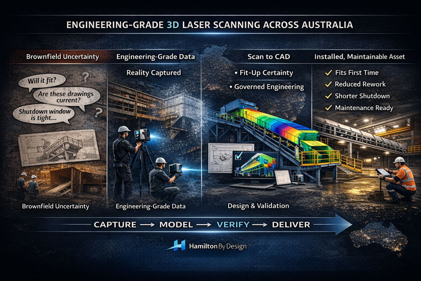
Executive infographic showing engineering-grade 3D laser scanning workflow from brownfield uncertainty to installed mining asset.

When a project slows down, itโ€™s rarely because the engineering team lacks capability. Itโ€™s usually because the site reality is unclear: legacy drawings donโ€™t match whatโ€™s installed, shutdown windows are tight, and one wrong assumption can cascade into rework, delays, and variation costs.

Engineering-grade 3D laser scanning is how you remove uncertainty early and build momentum fast.

At Hamilton By Design, we deliver 3D engineering scans that donโ€™t stop at โ€œcapturing points.โ€ We focus on engineering outcomesโ€”accurate as-built evidence, point cloud processing, scan-to-CAD modelling, and fit-for-purpose deliverables that support design, fabrication, and installation across mining and heavy industry.


Mining infrastructure upgrade workflow using LiDAR scanning, CAD modelling and engineering validation.

Why โ€œEngineering-Gradeโ€ Scanning Matters

Not all scanning services are equal. Scan density alone doesnโ€™t guarantee a usable engineering resultโ€”what matters is how the scan is controlled, interpreted, and translated into engineering decisions.

If youโ€™re planning upgrades in brownfield environments (plants, conveyors, chutes, pump skids, steelwork tie-ins), engineering-grade scanning helps you:

  • Verify true geometry before you design
  • Reduce shutdown risk and rework
  • Improve fit-up confidence for fabricated parts
  • Create accurate as-built documentation that stays useful over time

To understand what โ€œengineering-gradeโ€ really means, start here:
Engineering-Grade LiDAR Scanning (service page)
https://www.hamiltonbydesign.com.au/home/engineering-services/engineering-grade-lidar-scanning/

Engineering-Grade LiDAR Scanning (article/definition page)
https://www.hamiltonbydesign.com.au/engineering-grade-lidar-scanning/


Our Core 3D Engineering Scan Capability

3D Laser Scanning โ€“ Service Overview

This is the best โ€œhubโ€ page for prospects who want the full scanning capability and what it supports (engineering models, documentation, project delivery).
https://www.hamiltonbydesign.com.au/home/engineering-services/3d-laser-scanning/

3D Laser Scanning for Engineering

If your audience is engineers, project managers, and maintenance teams, this page speaks directly to engineering use-cases and how scanning reduces risk.
https://www.hamiltonbydesign.com.au/home/engineering-services/3d-laser-scanning/3d-laser-scanning-for-engineering/

Engineering-Grade 3D Laser Scanning Across Australia

For national capability (remote sites, shutdown support, travel-ready service delivery), use this page as the authority link.
https://www.hamiltonbydesign.com.au/engineering-grade-3d-laser-scanning-australia/

3D Laser Scanning Across Australia

A complementary national service page that reinforces coverage across mining, industry, and infrastructure.
https://www.hamiltonbydesign.com.au/home/engineering-services/3d-laser-scanning/3d-laser-scanning-across-australia/


Turning Point Clouds into Real Project Momentum

A point cloud is evidenceโ€”but the value is unlocked when that evidence becomes engineering geometry and fabrication-ready decisions.

Hamilton By Design supports scan-based workflows that typically include:

  • Scan control and site capture planning
  • Point cloud processing aligned to engineering datums
  • Model development for fit-up checks and tie-ins
  • Documentation updates and revision control pathways

For scanning + modelling capability in one place:
3D LiDAR Scanning and 3D Modelling (Sydney)
https://www.hamiltonbydesign.com.au/home/3d-lidar-scanning-and-3d-modelling-in-sydney/

For reverse engineering where the goal is better outcomes, not just copying old geometry:
Reverse Engineer 3D Scanning
https://www.hamiltonbydesign.com.au/reverse-engineer-3d-scanning/


Construction & Fit-Out Scanning (Sydney and Greater Metro)

For construction, retrofit, or building services environments, scanning often supports safe coordination, clash reduction, and fast design decisions.

If your audience includes builders, architects, MEP contractors, or refurbishment teams, link these pages:

3D Scanning for Construction in Sydney
https://www.hamiltonbydesign.com.au/home/engineering-services/3d-scanning-sydney/3d-scanning-for-construction-in-sydney/

3D Construction Scan Sydney
https://www.hamiltonbydesign.com.au/home/engineering-services/3d-scanning-sydney/3d-scanning-services-in-sydney/3d-construction-scan-sydney/

3D Scanning & BIM Across Greater Sydney
https://www.hamiltonbydesign.com.au/home/engineering-services/3d-scanning-sydney/3d-scanning-bim-greater-sydney/

3D LiDAR Scanning Chatswood & Greater Sydney
https://www.hamiltonbydesign.com.au/home/engineering-services/3d-scanning-sydney/3d-scanning-services-in-sydney/mechanical-engineers-in-sydney-hamilton-by-design/3d-lidar-scanning-chatswood/


Mining and Process Plant Scanning (CHPP and Heavy Industry)

Mining projects demand more than visual accuracyโ€”they demand engineering judgement around interfaces, access constraints, and shutdown deliverability.

If you want a clear scanning-to-mining outcome page, use:
CHPP Engineering, 3D Scanning & Upgrade Services
https://www.hamiltonbydesign.com.au/home/engineering-services/mining-engineering-services-australia/chpp-engineering-3d-scanning-upgrade-services/

For an educational/insight piece that supports credibility and internal linking:
How LiDAR Scanning is Transforming Mining Process Plants
https://www.hamiltonbydesign.com.au/seeing-the-unseen-how-lidar-scanning-is-transforming-mining-process-plants/


Regional and Project Delivery Pages

These pages are useful for local SEO and converting clients who search by region:

3D Scanning Engineering in Brisbane
https://www.hamiltonbydesign.com.au/home/engineering-services/3d-laser-scanning/3d-scanning-engineering-brisbane/

3D Laser Scanning & Mechanical Engineering in Wyong (NSW Central Coast)
https://www.hamiltonbydesign.com.au/nsw-central-coast/3d-laser-scanning-mechanical-engineering-in-wyong-nsw/


Ready to Start With an Engineering-Grade Scan?

If your project involves brownfield upgrades, shutdown tie-ins, or legacy infrastructure that canโ€™t be trusted from drawings alone, the fastest way to move forward is to capture reality, then design with certainty.

Start with the main scanning overview and follow the pathway that matches your project:


3D LiDAR scanning and 3D modelling service button โ€” laser scanner capturing a point cloud for engineering and CAD modelling
Mechanical engineering services
Name
Would you like us to arrange a phone consultation for you?
Address

3D CAD Modelling Australia service banner for Hamilton By Design

Mechanical Engineering | Structural Engineering


Why Projects Fail Before Construction Starts

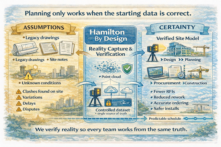
3D scanning reality capture workflow converting legacy drawings into a verified site model for construction planning.

The missing step between site reality and project planning

Most project delays donโ€™t begin during construction.

They begin months earlier โ€” at the planning stage.

Not because engineers lack skill.
Not because contractors lack experience.

But because decisions are made using incomplete or assumed information.


Construction planning comparison between assumed data and verified point-cloud model using laser scanning.

The hidden gap in almost every project

In industrial and brownfield environments, teams typically work from:

  • legacy drawings
  • outdated models
  • partial surveys
  • contractor interpretation
  • verbal site knowledge

Each group fills in the missing details differently.

The result is predictable:

  • clashes discovered during installation
  • materials ordered incorrectly
  • redesign during construction
  • variations and disputes
  • safety risks

The project didnโ€™t fail during construction.
It failed when planning began without verified reality.


Planning systems only work if the starting data is correct

Modern project environments rely heavily on structured planning:

  • scheduling
  • procurement
  • prefabrication
  • shutdown coordination
  • multi-contractor installation

But structured planning requires structured information.

If the starting information is uncertain, the entire workflow becomes an organised way of distributing errors.


The role of a reality-based dataset

Before a project can be planned properly, one thing must exist:

A trusted digital representation of the physical asset

This is not a drawing.
This is not a sketch.
This is not a collection of markups.

It is a measurable, verifiable record of what physically exists.

Once this exists:

  • engineers design accurately
  • planners sequence correctly
  • contractors install confidently
  • procurement orders correctly
  • changes are controlled

What our consultancy provides

Hamilton By Design acts as the bridge between site conditions and project planning.

We provide a structured workflow:

  1. Capture the physical environment using high-accuracy laser scanning
  2. Create a controlled digital model of the asset
  3. Make the data accessible to all project stakeholders
  4. Lock the dataset during design and upgrade phases
  5. Update the dataset following modifications

This creates a single project reference โ€” removing interpretation between disciplines.


The outcome for projects

Instead of discovering problems during installation, they are resolved during planning.

Instead of managing variations, teams manage decisions.

Instead of reacting to site conditions, teams design around verified reality.


The value of independent verification

Our role is not to design the system or build the works.

Our role is to ensure every party begins with the same trusted information.

When reality is agreed, coordination becomes straightforward.


Before planning, establish certainty

Projects do not fail because teams are incapable.
They fail because teams start from different assumptions.

Providing a verified digital record of the site removes those assumptions.

And once assumptions disappear โ€” so do most surprises.


Hamilton By Design
Creating trusted project reality before planning begins.

Name
Would you like us to arrange a phone consultation for you?
Address


3D LiDAR scanning and 3D modelling service button โ€” laser scanner capturing a point cloud for engineering and CAD modelling
Mechanical engineering services
Finite Element Analysis (FEA) engineering simulation button
Mechanical engineering services

Mechanical Engineering | Structural Engineering


3D Laser Scanning Brisbane โ€“ From Site Capture to Engineering Outcomes

Grey pencil drawing of 3D laser scanning in Brisbane showing an engineer, LiDAR scanner, point cloud data, industrial plant, CAD model workflow and fabrication drawings.

3D Laser Scanning Brisbane | Site Capture to Engineering Outcomes

A Connected Workflow for Reliable Project Delivery

Most projects in Brisbane do not begin with empty space.
They begin with existing buildings, infrastructure and operating facilities.

Over time, equipment is replaced, services are rerouted and structures are modified. Drawings rarely keep pace with reality. When upgrades are designed from outdated information, installation conflicts and construction delays follow.

3D laser scanning allows project teams to start with measured conditions rather than assumptions.

Hamilton By Design provides a connected workflow โ€” from site capture through to engineering modelling โ€” supporting accurate design and predictable installation.


3D LiDAR scanning services across Australia for mining and industrial facilities

Step 1 โ€” Capture the Real Conditions

Start with measured reality

The first step is collecting reliable site data using high-accuracy LiDAR scanning. This creates a spatial record of structures, services and equipment exactly as they exist.

3D Scanning Brisbane
https://www.hamiltonbydesign.com.au/laser-scanning-engineering-brisbane-cbd/3d-scanning-brisbane/

This process replaces manual measurement and reduces uncertainty before design begins.


Step 2 โ€” Apply Engineering Understanding

Turn measurements into decisions

Scan data alone does not solve problems โ€” interpretation does.
Engineering review ensures the captured data supports real project outcomes such as upgrades, replacements and modifications.

3D Scanning Engineering Brisbane
https://www.hamiltonbydesign.com.au/home/engineering-services/3d-laser-scanning/3d-scanning-engineering-brisbane/

This stage identifies constraints, access limitations and constructability issues before fabrication.


Step 3 โ€” Develop Buildable Models

Create fabrication-ready information

Once verified, the measured conditions are converted into coordinated models used by designers, fabricators and contractors.

Scan to CAD Brisbane
https://www.hamiltonbydesign.com.au/scan-to-cad-brisbane/

Accurate models allow components to be designed to fit existing conditions rather than adjusted in the field.


Step 4 โ€” Apply to Real Projects

Support upgrades and modifications

Reliable as-built information improves planning and installation across many sectors:

3D Scanning Services in Brisbane
https://www.hamiltonbydesign.com.au/laser-scanning-engineering-brisbane-cbd/3d-scanning-brisbane/3d-scanning-services-in-brisbane/

Typical applications include industrial upgrades, infrastructure changes and facility modifications.


Why a Connected Workflow Matters

Many project delays occur because measurement, modelling and engineering are treated as separate tasks. When they are integrated, problems are identified earlier and resolved more efficiently.

This approach helps:

  • reduce rework
  • shorten shutdown durations
  • improve installation certainty
  • support accurate fabrication

Instead of reacting to site conditions, projects are planned around them.


Hamilton By Design logo displayed on a blue tilted rectangle with a grey gradient background

Engineering Starts With Reliable Information

The quality of the final outcome depends on the quality of the starting data.
When existing conditions are known, design becomes predictable.

By linking site capture, modelling and engineering decisions, projects can move forward with confidence.

If your project depends on existing assets, accurate measurement is the first step toward reliable delivery.

3D LiDAR scanning and 3D modelling service button โ€” laser scanner capturing a point cloud for engineering and CAD modelling
Mechanical engineering services
Name
Would you like us to arrange a phone consultation for you?
Address

3D CAD Modelling Australia service banner for Hamilton By Design
Reality Capture Brisbane title graphic with white text on a blue background promoting reality capture, LiDAR scanning and digital engineering services in Brisbane, Queensland.
3D Scanning Brisbane text graphic on a blue background promoting engineering-led laser scanning and reality capture services in Brisbane.

LiDAR Scanning Brisbane title graphic with white text on a blue background promoting terrestrial LiDAR scanning, point cloud capture and reality capture services in Brisbane, Queensland.
SolidWorks Brisbane title graphic with white text on a blue background promoting SolidWorks mechanical design, 3D CAD modelling and engineering drafting services in Brisbane, Queensland.


LiDAR Scanning for Industrial Retrofit Engineering

Industrial facility captured using 3D laser scanning for brownfield plant upgrade

LiDAR Scanning for Industrial Retrofit Engineering | Brownfield Plant As-Built Capture

Steel Mills, Manufacturing Plants & Legacy Facility Upgrades

Across industrial regions such as Pittsburgh, Carnegie and Norristown, engineering teams are not scanning sites for mapping โ€” they are scanning them because they are about to change something critical.

Brownfield facilities rarely match drawings.
Plant modifications fail when decisions are made from assumptions rather than measurements.

Hamilton By Design provides engineering-grade LiDAR scanning and modelling specifically for retrofit engineering โ€” capturing existing assets so upgrades install correctly the first time.


Engineer performing industrial LiDAR scan of a processing plant for retrofit design

Why Industrial Facilities Require Scanning Before Design

In heavy industry the problem is rarely design capability โ€” it is uncertainty of the existing plant.

Old facilities typically contain:

  • undocumented structural alterations
  • relocated services and pipework
  • equipment installed over decades
  • distorted steelwork
  • unavailable or unreliable drawings

When upgrades are designed from historical drawings, fabrication errors and shutdown overruns occur.

Our process replaces assumption with measured reality.

We capture what actually exists โ€” then design from truth.

Hamilton By Design combines mechanical engineering with LiDAR capture to reduce fabrication and installation risk on operating assets.


Typical Projects Supported

Brownfield Industrial Plants

  • plant expansions
  • conveyor modifications
  • structural replacement
  • maintenance shutdown preparation

Steel Mills & Heavy Manufacturing

  • equipment replacement
  • platform and access upgrades
  • retrofit guarding & compliance
  • mechanical component redesign

Utilities & Processing Facilities

  • pipe routing development
  • pump and tank replacement
  • asset life-extension upgrades
  • tie-in engineering

These projects require accurate as-built conditions before design โ€” not survey grade positioning, but engineering-grade dimensional certainty.


Our Retrofit Engineering Workflow

1. Field Capture โ€” Engineering LiDAR Scanning

We capture operating facilities without interrupting production and obtain full spatial reality of structures, equipment and services.

2. Digital As-Built Model

Point cloud data is converted into coordinated 3D engineering models for decision-making and clash prevention.

3. Mechanical & Structural Design

Designs are developed directly from measured geometry rather than historic drawings.

4. Fabrication-Ready Deliverables

We provide models and drawings suitable for fabrication and installation.

This approach allows components to fit existing plant conditions on installation rather than being adjusted in the field.


What This Solves

Industrial retrofit projects fail due to dimensional unknowns โ€” not poor engineering.

LiDAR-driven design removes:

  • shutdown delays
  • rework fabrication
  • on-site modifications
  • installation conflicts
  • access clashes

Hamilton By Design supports manufacturing, processing and heavy industry with accurate as-built data and coordinated models for upgrades, maintenance and asset life-extension projects.


Engineering-Led Scanning โ€” Not Just Surveying

Many scanning providers supply point clouds.

We provide engineering decisions.

The difference is accountability โ€” one team responsible from measurement to design.

One team accountable from scan to fabrication.


When to Engage Us

Engage scanning early when a project involves:

  • replacing equipment
  • modifying structure
  • adding services
  • shutdown installation
  • upgrading legacy facilities

If fabrication depends on existing conditions, scanning should precede design โ€” not follow it.


Hamilton By Design logo displayed on a blue tilted rectangle with a grey gradient background

Talk to Hamilton By Design

Hamilton By Design delivers engineering-grade LiDAR scanning and retrofit design support for operating industrial assets worldwide.

Reduce installation risk.
Design from measured reality.

Name
Would you like us to arrange a phone consultation for you?
Address
Name
Would you like us to arrange a phone consultation for you?
Address

3D CAD Modelling Australia service banner for Hamilton By Design
3D LiDAR scanning and 3D modelling service button โ€” laser scanner capturing a point cloud for engineering and CAD modelling
Mechanical engineering services
Finite Element Analysis (FEA) engineering simulation button
Mechanical engineering services