LiDAR Accuracy in Engineering Applications

LiDAR scanning workflow showing an engineering laser scanner capturing industrial infrastructure and converting the data into a point cloud and CAD model.

Understanding LiDAR Accuracy for Engineering Projects

In modern engineering projects, capturing accurate measurements of existing infrastructure is critical before design work begins. LiDAR accuracy engineering plays a central role in this process by allowing engineers to capture millions of precise measurements of structures, plant equipment, and terrain in a matter of minutes.

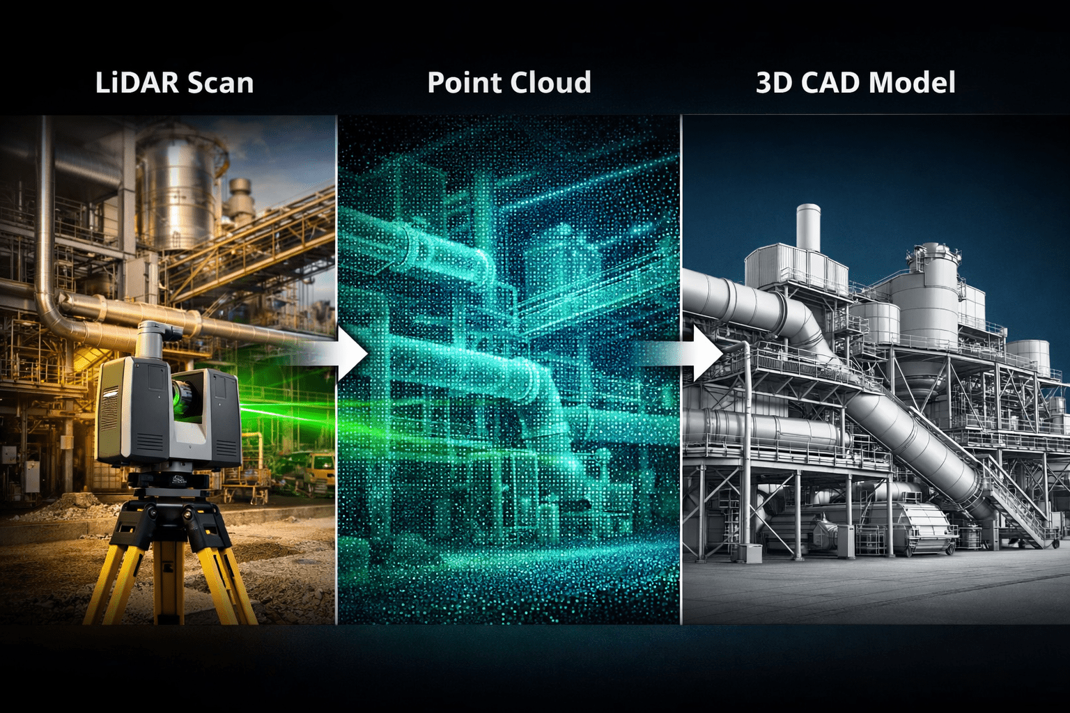
LiDAR (Light Detection and Ranging) technology uses laser pulses to measure distances to surfaces and create a detailed 3D point cloud model of the scanned environment. These datasets provide engineers with reliable dimensional information that can be used for plant upgrades, mechanical design, structural modifications, and site documentation.

At Hamilton By Design, LiDAR scanning is commonly used to capture existing conditions for mining infrastructure, industrial facilities, and complex engineering environments.

You can learn more about our scanning services here:


What Determines LiDAR Accuracy in Engineering?

Several factors influence the overall accuracy of LiDAR scanning in engineering applications.

1. Scanner Hardware Accuracy

Modern engineering-grade scanners typically provide millimetre-level accuracy. High-end terrestrial LiDAR scanners commonly achieve:

โ€ข ยฑ1โ€“3 mm accuracy at 10 metres
โ€ข ยฑ2โ€“6 mm accuracy across larger industrial spaces
โ€ข Millions of points captured per second

These scanners allow engineers to measure structures without physical contact while maintaining high dimensional reliability.

Hamilton By Design uses professional scanning workflows designed specifically for engineering environments such as mining plants, conveyors, pump stations, and processing infrastructure.

More about these applications:

https://www.hamiltonbydesign.com.au/home/engineering-services/3d-laser-scanning/3d-laser-scanning-across-australia


2. Scan Setup and Registration

Accuracy is not only determined by the scanner itself. It also depends on how the scans are set up and aligned together.

During a project, multiple scans are captured from different positions and then registered together to create a complete 3D dataset.

Proper registration ensures:

โ€ข accurate alignment of overlapping scans
โ€ข minimal cumulative error across large sites
โ€ข reliable geometry for engineering modelling

In mining plants or processing facilities, dozens or sometimes hundreds of scans may be combined to create a full site model.


3. Surface Conditions and Environment

The environment being scanned also affects measurement accuracy.

Common factors include:

โ€ข reflective metal surfaces
โ€ข dust or airborne particles
โ€ข complex pipework and structural steel
โ€ข long scanning distances

Experienced operators account for these factors by selecting optimal scan locations and controlling the scanning workflow.

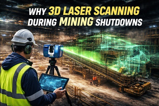
This is particularly important during shutdown projects or plant upgrades, where accurate measurements must be captured quickly.

See how scanning supports shutdown projects:


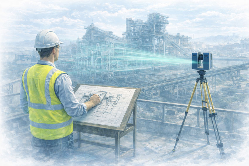
From LiDAR Data to Engineering Models

Once scanning is complete, the raw point cloud data is processed and converted into engineering models.

Typical workflow includes:

  1. Site LiDAR scanning
  2. Point cloud registration
  3. Data cleaning and segmentation
  4. Conversion to engineering models
  5. CAD design and drafting

The result is a highly accurate digital representation of the existing infrastructure, allowing engineers to design modifications with confidence.

A detailed explanation of this process can be found here:


Why LiDAR Accuracy Matters in Engineering Design

The accuracy of LiDAR scanning directly impacts engineering outcomes.

High-quality scan data helps engineers:

โ€ข avoid clashes with existing structures
โ€ข reduce site rework during installation
โ€ข shorten shutdown durations
โ€ข design prefabricated components
โ€ข improve documentation of existing assets

For mining and industrial environments, this level of accuracy significantly reduces project risk.

You can also read more about capturing existing conditions before plant upgrades here:


LiDAR Accuracy vs Traditional Measurement

Traditional measurement methods often rely on manual tape measurements, total stations, or site sketches.

While useful, these methods can introduce gaps in documentation.

LiDAR scanning provides several advantages:

MethodTypical AccuracyData DensitySite Time
Manual measurementVariableLowHigh
Total station surveyHighMediumModerate
LiDAR scanningMillimetre-levelExtremely HighVery Fast

Because LiDAR captures millions of measurement points, engineers gain a complete digital record of the site rather than a limited set of measurements.


LiDAR Accuracy for Mining and Industrial Engineering

Industries that benefit most from LiDAR accuracy include:

โ€ข mining operations
โ€ข mineral processing plants
โ€ข pump stations
โ€ข materials handling systems
โ€ข heavy industrial facilities

These environments typically contain complex pipework, structural steel, and equipment layouts where traditional measurement can be difficult.

Engineering-grade scanning provides a reliable foundation for future design work.


Engineering Applications of LiDAR Scanning

Some common engineering applications include:

โ€ข plant upgrade design
โ€ข piping modifications
โ€ข structural steel design
โ€ข conveyor and materials handling systems
โ€ข pump and mechanical equipment installations
โ€ข shutdown planning and prefabrication

At Hamilton By Design, these datasets are frequently converted into SolidWorks engineering models used for mechanical design and fabrication documentation.


Conclusion

The accuracy of LiDAR scanning in engineering applications has transformed how engineers capture and document complex infrastructure.

With millimetre-level accuracy, LiDAR allows engineering teams to build precise digital models of existing environments and design upgrades with confidence.

For industries such as mining and heavy industrial processing, this capability reduces project risk, improves design reliability, and enables faster project delivery.

Hamilton By Design provides engineering-grade LiDAR scanning services to support plant upgrades, shutdown projects, and mechanical design across Australia.

3D LiDAR scanning and 3D modelling service button โ€” laser scanner capturing a point cloud for engineering and CAD modelling
Mechanical engineering services
Name
Would you like us to arrange a phone consultation for you?
Address
Hamilton By Design logo displayed on a blue tilted rectangle with a grey gradient background
3D CAD Modelling Australia service banner for Hamilton By Design

Why 3D Laser Scanning is Critical During Mining Shutdowns

Engineer performing 3D laser scanning of a mining processing plant during a shutdown to capture accurate site conditions.

Mining shutdowns are among the most complex and high-pressure events in heavy industry. Whether the shutdown is scheduled for a processing plant, conveyor system, pump station, or structural upgrade, every hour of downtime carries significant cost.

Engineering teams must inspect, measure, design, fabricate, and install upgrades within an extremely tight timeframe. Any unexpected interference, misalignment, or dimensional error can delay commissioning and extend the shutdown.

This is why 3D laser scanning has become a critical technology for mining shutdown planning and execution.

By capturing millions of accurate measurement points in a matter of minutes, laser scanning provides engineers with a complete digital representation of existing plant conditions. These highly detailed point cloud models allow engineers to design upgrades with confidence before the shutdown even begins.

For mining operations across Australia, this approach significantly reduces risk, improves installation accuracy, and shortens shutdown durations.


3D laser scanner capturing point cloud data across a mining facility during shutdown maintenance.

The Challenge of Mining Shutdown Engineering

Mining infrastructure evolves continuously. Over decades of modifications, maintenance work, and operational changes, the as-built condition of a plant rarely matches the original drawings.

Typical shutdown upgrade projects may involve:

  • Conveyor realignments
  • Chute redesigns
  • Pump station upgrades
  • Structural steel modifications
  • Platform and access upgrades
  • Pipework tie-ins and maintenance replacements

If the design team relies on outdated drawings or manual measurements, there is a significant risk that fabricated components will not fit during installation.

In a shutdown environment, discovering a fit-up issue onsite can quickly escalate into costly delays.

Accurate site data is therefore the foundation of effective shutdown planning.


What is 3D Laser Scanning?

3D laser scanning is a reality-capture technology that records the physical environment using millions of laser measurements per second.

The result is a high-resolution point cloud representing the exact geometry of the plant, equipment, and surrounding structures.

Engineers can then convert this data into detailed 3D models used for:

  • Engineering design
  • Clash detection
  • Fabrication drawings
  • Layout verification
  • Maintenance planning

The technology allows engineers to capture large industrial facilities quickly and accurately while minimizing disruption to site operations.

Learn more about the technology here:


How 3D Scanning Improves Shutdown Planning

Accurate As-Built Plant Models

One of the biggest advantages of laser scanning is the ability to capture the true geometry of an operating plant.

Instead of relying on assumptions, engineers can design within a precise digital twin of the facility, ensuring that new equipment or structures will fit exactly as intended.

This eliminates many of the dimensional errors that traditionally occur during shutdown installations.


Faster Site Data Capture

Traditional surveying methods can take days to measure complex industrial plants.

Laser scanning dramatically accelerates this process by capturing millions of measurements in minutes.

This speed is particularly valuable during shutdown preparation because it allows engineering teams to collect comprehensive data without extended site access requirements.


Clash Detection Before Fabrication

A common shutdown problem occurs when newly fabricated equipment clashes with existing infrastructure such as pipes, structural steel, cable trays, or maintenance access routes.

By designing directly inside the scanned model, engineers can perform clash detection and clearance analysis before fabrication begins.

This ensures that components will install smoothly during the shutdown window.


Reduced Rework and Installation Delays

When plant modifications are designed using precise scan data, installation crews spend less time cutting, grinding, or modifying fabricated components onsite.

This leads to:

  • Faster installations
  • Lower shutdown risk
  • Improved safety outcomes
  • Reduced hot work and manual handling

The result is a more predictable shutdown schedule and fewer unexpected delays.


Supporting Mining Plant Upgrades

3D scanning plays a major role in engineering upgrades across mining processing plants.

Typical projects supported by scanning include:

  • CHPP chute redesign and transfer upgrades
  • Conveyor realignment and structural modifications
  • Pump and piping system upgrades
  • Walkway and platform installation
  • Structural inspections and reinforcement

Hamilton By Design regularly applies this workflow to plant upgrade projects where accurate site information is critical.

You can learn more about this process here:


Engineering-Grade Scanning Across Australia

Mining operations across Australia are increasingly adopting 3D scanning because it enables faster engineering decisions and more reliable shutdown execution.

By combining laser scanning with engineering modelling tools such as SolidWorks and advanced analysis workflows, project teams can move from site capture to fabrication-ready designs much faster than traditional survey methods allow.

Hamilton By Design provides engineering-grade scanning services for industrial facilities across the country.

Explore the national service offering here:


The Future of Digital Mining Shutdowns

The mining industry is rapidly adopting digital engineering tools to reduce operational risk and improve plant reliability.

Technologies such as:

  • 3D laser scanning
  • Digital twins
  • LiDAR modelling
  • Reality capture workflows

are transforming how shutdown projects are planned and delivered.

Instead of reacting to problems during installation, engineers can now identify risks months before the shutdown begins.

For operations where downtime can cost hundreds of thousands of dollars per hour, this shift toward data-driven engineering is a major competitive advantage.

3D LiDAR scanning and 3D modelling service button โ€” laser scanner capturing a point cloud for engineering and CAD modelling
Mechanical engineering services

Hamilton By Design logo displayed on a blue tilted rectangle with a grey gradient background

Final Thoughts

Mining shutdowns demand precision, speed, and certainty.

3D laser scanning provides engineers with the accurate site data needed to design plant upgrades that fit the first time.

By capturing existing conditions with millimetre-level accuracy, engineers can eliminate guesswork, reduce installation risks, and ensure shutdown projects are delivered safely and efficiently.

For modern mining operations, 3D laser scanning is no longer optional โ€” it is a critical tool for successful shutdown execution.


Name
Would you like us to arrange a phone consultation for you?
Address

3D CAD Modelling Australia service banner for Hamilton By Design

Engineering-Led LiDAR & Mechanical Design for Mining & Heavy Industry โ€“ Singleton NSW

Engineer-led LiDAR scanning at a mining heavy-industry site with point cloud overlay used for mechanical design and brownfield engineering.

Engineering-Led LiDAR & Mechanical Design for Mining & Heavy Industry โ€“ Singleton NSW

Hamilton By Design provides engineering-led LiDAR scanning and mechanical design services to support mining and heavy-industry projects in Singleton and the Upper Hunter Valley, NSW. Our work focuses on brownfield assets, live operating plant, and shutdown-driven projects where accuracy, constructability, and risk control are critical.

This is not survey-only scanning. We integrate engineering judgement with high-accuracy reality capture to deliver fabrication-ready, fit-first-time outcomes for coal operations, CHPPs, and associated mining infrastructure across the Hunter Valley.


Mechanical engineer capturing a mining plant with LiDAR scanning, showing point cloud data integrated into engineering design workflows.

Engineering-Led LiDAR for the Hunter Valley Mining Region

Mining operations around Singleton operate in one of Australiaโ€™s most established coal regions, characterised by:

  • Long-life assets with decades of incremental modification
  • Incomplete or outdated as-built documentation
  • Tight shutdown windows aligned to production constraints
  • High consequence of rework in live operating environments

Our engineering-led LiDAR approach is designed for operating mine sites and processing facilities where assumptions introduce safety, cost, and schedule risk.


Integrated Scan-to-Engineering Workflow

We deliver a single, accountable workflow tailored to Hunter Valley mining operations:

  1. On-site LiDAR scanning undertaken by engineers familiar with coal operations, access constraints, and site safety requirements
  2. Engineering-grade point-cloud processing aligned to modelling tolerances and fabrication requirements
  3. Mechanical and structural CAD modelling developed directly from scan data
  4. Fabrication-ready drawings suitable for workshop manufacture and site installation
  5. Engineering support through fabrication, installation, and shutdown execution

This workflow reduces interface risk between scanning, design, fabrication, and construction โ€” a key issue on shutdown-critical coal sites.


Mining & Heavy Industry Applications in Singleton

Brownfield Engineering & Existing Assets

Singleton-region operations rely heavily on brownfield plant and infrastructure that has evolved over decades. We support brownfield engineering where:

  • Original drawings are unreliable or unavailable
  • Multiple generations of modifications exist
  • Interface accuracy and access are critical

LiDAR provides accurate existing-condition data, while engineering oversight ensures the information is applied correctly during design and verification.


Shutdown-Driven Projects

Shutdowns in the Hunter Valley are tightly planned and production-critical.

Our work supports shutdown success by:

  • Capturing existing conditions prior to outages
  • Eliminating site measurement during shutdowns
  • Verifying interfaces, access, and constructability
  • Reducing fabrication and installation risk

Pre-validated designs improve safety, execution quality, and schedule certainty.


CHPP & Bulk Materials Handling

Coal Handling and Preparation Plants dominate the Upper Hunter Valley.

Our engineering-led LiDAR services support:

  • Conveyors and transfer stations
  • Hoppers, bins, and chutes
  • Crushers, screens, and feeders
  • Walkways, platforms, and guarding upgrades

Accurate scan-to-CAD workflows enable confident redesign, replacement, and compliance upgrades in operating CHPP environments.


Heavy Plant & Mining Equipment

We support projects involving large and complex coal-handling plant where traditional measurement methods are unsafe or impractical, including:

  • Stackers and reclaimers
  • Large conveyor systems
  • Structural steelwork and access platforms

Engineering-led scanning ensures interfaces, envelopes, and installation constraints are understood before fabrication begins.


Risk Management for Hunter Valley Mining Projects

In mature coal regions like Singleton, risk is driven by unknown conditions, interface complexity, and limited tolerance for shutdown overruns.

Our approach reduces risk by:

  • Removing reliance on outdated drawings and assumptions
  • Capturing accurate existing conditions prior to design
  • Identifying clashes and access constraints early
  • Reducing site rework and hot works
  • Supporting safer shutdown execution

Risk is managed upstream, where it is cheapest and safest to control.


What Makes Our Approach Different

  • Engineer-led LiDAR scanning, not technician-only capture
  • Mechanical and structural engineering capability in-house
  • Coal and heavy-industry focus
  • Brownfield and shutdown experience
  • Single point of responsibility from scan through to design output

Typical Deliverables

Depending on project scope, deliverables may include:

  • Registered point-cloud datasets
  • Engineering-grade 3D CAD models
  • Mechanical and structural drawings
  • Interface and clearance verification
  • Fabrication and installation documentation

All deliverables are developed with fabrication, installation, and operational use in mind.


Hamilton By Design logo displayed on a blue tilted rectangle with a grey gradient background
3D LiDAR scanning and 3D modelling service button โ€” laser scanner capturing a point cloud for engineering and CAD modelling
Mechanical engineering services

Who We Support

Our services support:

  • Coal mine asset owners and operators
  • CHPP operators
  • Maintenance and shutdown teams
  • Project engineers and managers
  • Fabricators and constructors operating in the Upper Hunter Valley

We work directly with asset owners or as part of multi-disciplinary project teams.


Talk to an Engineer

If you are planning:

  • A brownfield upgrade
  • A shutdown-driven project
  • CHPP modifications or replacements
  • Conveyor or heavy plant upgrades

Hamilton By Design can support your project in Singleton and the Upper Hunter Valley with engineering-led LiDAR scanning and mechanical design.

Contact us to discuss your site, constraints, and project objectives.

Name
Would you like us to arrange a phone consultation for you?
Address

Our clients:


Engineering-Led LiDAR & Mechanical Design for Mining & Heavy Industry โ€“ Mount Isa QLD

Engineer-led LiDAR scanning at a mining heavy-industry site with point cloud overlay used for mechanical design and brownfield engineering.

Engineering-Led LiDAR & Mechanical Design for Mining | Mount Isa QLD

Hamilton By Design provides engineering-led LiDAR scanning and mechanical design services for mining and heavy-industry operations in Mount Isa and North West Queensland. Our work supports brownfield assets, live operating plant, and shutdown-driven projects where accuracy, risk control, and constructability are critical.

This is not survey-only scanning. We integrate engineering judgement with high-accuracy reality capture to deliver fabrication-ready, fit-first-time outcomes for base metals operations, processing plants, and heavy industrial infrastructure in remote and operationally constrained environments.


Mechanical engineer capturing a mining plant with LiDAR scanning, showing point cloud data integrated into engineering design workflows.

Engineering-Led LiDAR for North West Queensland Mining

Mining operations in Mount Isa face unique challenges:

  • Remote location and logistics constraints
  • Legacy infrastructure with limited as-built documentation
  • Continuous operations with minimal downtime
  • High consequence of rework during shutdowns

Our engineering-led LiDAR approach is designed specifically for operating mine sites where assumptions carry cost, safety, and schedule risk.


Integrated Scan-to-Engineering Workflow

We deliver a single, accountable workflow tailored to remote mining operations:

  1. On-site LiDAR scanning performed by engineers familiar with mining access, safety, and operational constraints
  2. Engineering-grade point-cloud processing aligned to modelling tolerances and fabrication requirements
  3. Mechanical and structural CAD modelling developed directly from scan data
  4. Fabrication-ready drawings suitable for workshop manufacture and site installation
  5. Engineering support through fabrication, installation, and commissioning

This approach reduces interface risk between scanning, design, fabrication, and construction โ€” particularly important in remote regions where rework is costly.


Mining & Heavy Industry Applications in Mount Isa

Brownfield Engineering & Existing Assets

Mount Isa operations rely heavily on long-life assets that have evolved over decades. We support brownfield engineering where:

  • Original drawings are incomplete or unavailable
  • Multiple generations of plant modifications exist
  • Clearances, interfaces, and access are critical

LiDAR provides accurate existing-condition data, while engineering oversight ensures the information is applied correctly during design and verification.


Shutdown-Driven Projects

Shutdown windows in remote operations are limited and tightly managed.

Our work supports shutdown success by:

  • Capturing existing conditions before outages
  • Eliminating site measurement during shutdowns
  • Verifying interfaces, access, and constructability
  • Reducing fabrication and installation risk

Pre-validated designs improve safety, schedule certainty, and execution quality.


Processing Plants & Bulk Materials Handling

Mining operations in Mount Isa include complex processing and materials-handling infrastructure.

Our engineering-led LiDAR services support:

  • Conveyors and transfer stations
  • Hoppers, bins, and chutes
  • Crushers, screens, and feeders
  • Walkways, platforms, and guarding upgrades

Accurate scan-to-CAD workflows enable confident redesign, replacement, and compliance upgrades in operating plants.


Heavy Plant & Industrial Equipment

We support projects involving large and complex equipment where traditional measurement methods are unsafe or impractical, including:

  • Fixed and mobile processing plant
  • Large structural steel assemblies
  • Access systems and maintenance platforms

Engineering-led scanning ensures interfaces, envelopes, and installation constraints are understood before fabrication begins.


Mining engineers applying design-for-safety principles to improve material handling systems in an industrial workshop

Risk Management for Remote Mining Projects

In remote mining environments, risk is amplified by distance, logistics, and limited tolerance for error.

Our approach reduces risk by:

  • Removing reliance on outdated or assumed information
  • Capturing accurate existing conditions prior to design
  • Identifying clashes and access constraints early
  • Reducing site rework and hot works
  • Supporting safer shutdown execution

Risk is managed upstream, where changes are cheapest and safest to implement.


What Makes Our Approach Different

  • Engineer-led LiDAR scanning, not technician-only capture
  • Mechanical and structural engineering capability in-house
  • Mining and heavy-industry focus
  • Brownfield and shutdown experience
  • Single point of responsibility from scan through to design output

Typical Deliverables

Depending on project scope, deliverables may include:

  • Registered point-cloud datasets
  • Engineering-grade 3D CAD models
  • Mechanical and structural drawings
  • Interface and clearance verification
  • Fabrication and installation documentation

All deliverables are developed with fabrication, installation, and operational use in mind.


Who We Support

Our services support:

  • Base metals and mining asset owners
  • Processing plant operators
  • Maintenance and shutdown teams
  • Project engineers and managers
  • Fabricators and constructors operating in North West Queensland

We work directly with asset owners or as part of multi-disciplinary project teams.


Hamilton By Design logo displayed on a blue tilted rectangle with a grey gradient background
3D LiDAR scanning and 3D modelling service button โ€” laser scanner capturing a point cloud for engineering and CAD modelling
Mechanical engineering services

Talk to an Engineer

If you are planning:

  • A brownfield upgrade
  • A shutdown-driven project
  • Processing plant modifications
  • Conveyor or heavy plant upgrades

Hamilton By Design can support your project in Mount Isa and North West Queensland with engineering-led LiDAR scanning and mechanical design.

Contact us to discuss your site, constraints, and project objectives.

Name
Would you like us to arrange a phone consultation for you?
Address

Our clients:


Engineering-Led LiDAR & Mechanical Design for Mining & Heavy Industry โ€“ Blackwater QLD

Engineer-led LiDAR scanning at a mining heavy-industry site with point cloud overlay used for mechanical design and brownfield engineering.

Engineering-Led LiDAR & Mechanical Design for Mining | Blackwater QLD

Hamilton By Design provides engineering-led LiDAR scanning and mechanical design services to support mining and heavy-industry projects in Blackwater and Central Queensland. Our work is focused on brownfield assets, live operating plant, and shutdown-driven projects where accuracy, constructability, and risk control are critical.

This is not survey-only scanning. We integrate reality capture with mechanical and structural engineering to deliver fabrication-ready, fit-first-time outcomes for coal operations, CHPPs, and associated infrastructure across the Bowen Basin.


Mechanical engineer capturing a mining plant with LiDAR scanning, showing point cloud data integrated into engineering design workflows.

Engineering-Led LiDAR for Central Queensland Mining

Mining operations in and around Blackwater operate under tight production constraints, legacy infrastructure, and demanding shutdown schedules. Generic scanning services rarely address the realities of these environments.

Our engineering-led LiDAR approach is designed for:

  • Brownfield coal mine and CHPP assets
  • Multiple generations of undocumented modifications
  • Restricted access and live plant constraints
  • Shutdown-driven upgrades and replacements
  • Zero-tolerance fabrication and installation risk

LiDAR data is captured, interpreted, and applied by engineers who understand how mining plant actually works.


Integrated Scan-to-Engineering Workflow

Our services are delivered as a single, accountable workflow:

  1. On-site LiDAR scanning by engineers familiar with mining operations and access constraints
  2. Engineering-grade point-cloud processing aligned to modelling and fabrication requirements
  3. Mechanical and structural CAD modelling developed directly from scan data
  4. Fabrication-ready drawings suitable for workshops and shutdown execution
  5. Engineering support through fabrication, installation, and commissioning

This approach reduces interface risk between surveyors, designers, fabricators, and constructors โ€” a key issue on remote and shutdown-critical sites.


Mining & Heavy Industry Applications in Blackwater

Brownfield Engineering & Existing Assets

Coal operations in Central Queensland rely heavily on legacy plant and infrastructure. We support brownfield engineering where:

  • As-built drawings are incomplete or unreliable
  • Equipment has evolved through multiple shutdowns
  • Interface accuracy is critical to avoid rework

LiDAR provides accurate existing-condition data, while engineering oversight ensures the information is applied correctly during design.


Shutdown-Driven Projects

Shutdown windows are short and unforgiving.

Our work supports shutdown success by:

  • Capturing existing conditions before outages
  • Eliminating site measurement during shutdowns
  • Verifying interfaces, clearances, and constructability
  • Reducing fabrication and installation risk

Pre-validated designs lead to safer execution and reduced schedule overruns.


CHPP & Bulk Materials Handling

Blackwater and the Bowen Basin are dominated by CHPP and bulk materials infrastructure.

Our engineering-led LiDAR services support:

  • Conveyors and transfer stations
  • Hoppers, bins, and chutes
  • Crushers, screens, and feeders
  • Walkways, platforms, and guarding upgrades

Accurate scan-to-CAD workflows enable confident redesign, replacement, and compliance upgrades.


Heavy Plant & Mining Equipment

We support projects involving large and complex mining plant where traditional measurement methods are impractical or unsafe, including:

  • Stackers and reclaimers
  • Large conveyor systems
  • Structural steelwork and access systems

Engineering-led scanning ensures interfaces, notice envelopes, and installation constraints are understood before fabrication begins.


Risk Management for Mining Projects

In mining environments, risk is driven by unknown conditions, time pressure, and interface errors.

Our approach reduces risk by:

  • Removing reliance on outdated drawings
  • Capturing existing conditions prior to design
  • Identifying clashes and access issues early
  • Reducing hot works and site rework
  • Supporting safer shutdown execution

Risk is addressed upstream, where it is cheapest and safest to control.


Mining engineers applying design-for-safety principles to improve material handling systems in an industrial workshop

What Makes Our Approach Different

  • Engineer-led LiDAR scanning, not technician-only capture
  • Mechanical and structural engineering in-house
  • Coal and heavy-industry focus
  • Brownfield and shutdown experience
  • Single point of responsibility from scan through to design output

Typical Deliverables

Depending on project scope, deliverables may include:

  • Registered point-cloud datasets
  • Engineering-grade 3D CAD models
  • Mechanical and structural drawings
  • Interface and clearance verification
  • Fabrication and installation documentation

All deliverables are developed with fabrication, installation, and operational use in mind.


Who We Support

Our services support:

  • Coal mine asset owners
  • CHPP operators
  • Maintenance and shutdown teams
  • Project engineers and managers
  • Fabricators and constructors operating in Central Queensland

We work directly with asset owners or as part of multi-disciplinary project teams.


Hamilton By Design logo displayed on a blue tilted rectangle with a grey gradient background

Talk to an Engineer

If you are planning:

  • A brownfield upgrade
  • A shutdown-driven project
  • CHPP modifications or replacements
  • Conveyor or heavy plant upgrades

Hamilton By Design can support your project in Blackwater and Central Queensland with engineering-led LiDAR scanning and mechanical design.

Contact us to discuss your site, constraints, and project objectives.

Name
Would you like us to arrange a phone consultation for you?
Address

Our clients:


Finite Element Analysis (FEA) engineering simulation button
Mechanical engineering services

3D Scanning Engineering in Broken Hill

3D Scanning Engineering in Broken Hill

Broken Hill is unlike any other engineering environment in Australia. Shaped by one of the worldโ€™s most significant ore bodies, the cityโ€™s infrastructure has evolved over more than a century of continuous mining. Much of what exists today is layered, modified, and adapted over time, creating complex brownfield conditions where original drawings are often incomplete or no longer reflect reality.

Engineering in Broken Hill is therefore highly practical, conservative, and focused on working with what already exists. This is where accurate site data and engineer-led digital workflows become essential.

Hamilton By Design supports projects in Broken Hill by combining 3D LiDAR laser scanning, mechanical and structural engineering, 3D CAD modelling, FEA, and fabrication-ready draftingโ€”helping asset owners and project teams design upgrades that fit first time.

Engineering challenges unique to Broken Hill

Broken Hill engineering is dominated by:

  • Very old and continuously modified infrastructure
  • Underground and surface assets built to historic standards
  • Extreme heat, dust, and isolation
  • Limited tolerance for rework due to logistics and access

In this environment, assumptions are risky. Accurate as-built information is critical before any design, fabrication, or installation begins.

3D Laser Scanning for Broken Hill sites

Hamilton By Design uses high-accuracy 3D Laser Scanning to capture the true as-built condition of mining and industrial assets in and around Broken Hill.

3D laser scanning is particularly valuable for:

  • Brownfield mining infrastructure
  • Historic plant and structural steel
  • Underground and surface interfaces
  • Assets where drawings are outdated or missing

Scanning is completed during controlled site visits, minimising disruption while capturing comprehensive data that can be relied on throughout the project lifecycle.

Turning scan data into practical engineering models

Once scanning is complete, data is transferred off site for processing and engineering. Hamilton By Design converts point cloud data into accurate 3D CAD Modelling that reflects what actually existsโ€”not what drawings suggest should exist.

These models support:

  • Mechanical upgrades and equipment replacements
  • Structural strengthening and retrofits
  • Platforms, access ways, and support steel
  • Integration of new assets into constrained spaces

For Broken Hill projects, this scan-to-model approach significantly reduces uncertainty and design risk.

Mechanical and structural engineering built on reality

Engineering in Broken Hill often involves integrating modern systems into historic assets. Working from scan-derived models allows engineers to:

  • Understand existing load paths and constraints
  • Check clearances and access early
  • Coordinate mechanical and structural elements in one environment

This leads to designs that are practical, buildable, and aligned with site realities rather than idealised assumptions.

FEA to support safety and compliance

Where performance, safety, or compliance is critical, Hamilton By Design applies FEA Capabilities to verify designs.

Finite Element Analysis is commonly used to:

  • Check structural capacity of existing assets
  • Assess modifications to aged steel and supports
  • Review fatigue, vibration, and deflection
  • Support engineering approval and sign-off

Using FEA on scan-based geometry provides confidence that designs will perform as intended in real operating conditions.

Easy-to-build fabrication drawings with engineering approval

Clear documentation is essential for successful delivery in remote locations like Broken Hill. Hamilton By Design produces fabrication-ready Drafting directly from coordinated 3D models.

Typical deliverables include:

  • General arrangement and detail drawings
  • Fabrication and installation drawings
  • Engineering-reviewed and approval-ready documentation

This focus on clarity and constructability helps fabricators and site teams build accurately, safely, and efficientlyโ€”often with limited opportunity for rework.

Reducing site risk through digital engineering

By capturing site conditions once and completing the majority of engineering off site, projects benefit from:

  • Fewer site visits and lower travel costs
  • Reduced safety exposure
  • Better coordination before fabrication
  • Higher confidence during installation

For Broken Hill, where logistics and access matter, this approach delivers measurable value.

Engineering outcomes that respect history and reality

Broken Hill is a place where past and present engineering coexist. Hamilton By Designโ€™s integrated scanning and engineering workflow helps bridge that gapโ€”respecting historic infrastructure while delivering modern, compliant, and buildable solutions.

3D Scanning Engineering in Broken Hill is about using accurate data, sound engineering judgement, and practical documentation to deliver upgrades that work the first time.

Hamilton By Design logo displayed on a blue tilted rectangle with a grey gradient background
3D LiDAR scanning and 3D modelling service button โ€” laser scanner capturing a point cloud for engineering and CAD modelling
Mechanical engineering services

Our Clients:

Name
Would you like us to arrange a phone consultation for you?
Address

3D Laser Scanning

3D LiDAR Scanning โ€“ Digital Quality Assurance

As-Built Drawings from a LiDAR Scanner

3D LiDAR Scanning and 3D Modelling – Hamilton By Design