Mechanical Engineering | 3D Scanning | 3D Modelling
Tag: industrial plant scanning
Industrial plant scanning services using engineering-grade LiDAR technology to capture existing conditions, generate point clouds, support as-built verification, and provide accurate engineering data for upgrades and project delivery.
Processing plants around Blayney NSW often include a mix of production equipment, conveyors, transfer systems, tanks, pipework, platforms, structural steel, access areas and packaging or handling equipment. Over time, these sites change. Equipment is upgraded, pipework is rerouted, platforms are modified, guarding is added and shutdown repairs are completed.
The problem is that the drawings do not always keep up with the real plant.
For engineers, maintenance teams, shutdown planners and fabricators, this can create delays and uncertainty before a project even begins. If the existing plant layout is difficult to verify from old drawings, it becomes harder to design new work, plan shutdowns, check access or fabricate components with confidence.
Hamilton By Design provides engineering-grade 3D LiDAR scanning, scan-to-CAD modelling and mechanical design support for processing plants and industrial sites in Blayney NSW and the wider Central West region.
Why Processing Plants Need Accurate As-Built Information
Many operating plants rely on old drawings, marked-up PDFs, previous project files or site sketches. These records may still be useful, but they are not always accurate enough for current design or fabrication work.
A processing plant may have changed through:
Conveyor or transfer system upgrades
New pipework or service routes
Modified platforms, stairs and handrails
Added guarding or access systems
Equipment replacement
Structural steel changes
Shutdown repairs
Production line upgrades
Packaging or palletising changes
Maintenance modifications not captured in the final drawing set
When the drawings no longer match the plant, the team is forced to work with assumptions. That can lead to extra site visits, delayed design decisions, fabrication rework and increased shutdown risk.
How 3D LiDAR Scanning Helps
3D LiDAR scanning captures the existing plant in detail and creates a measured point cloud of the site. This gives the project team a reliable digital reference of what is actually installed.
The scan data can be used to verify layouts, check clearances, measure difficult areas, model existing structures and support engineering design.
For brownfield processing plants, this is especially useful because new work often has to fit around existing equipment, steelwork, pipework and access constraints.
3D scanning can assist with:
Plant layout verification
Shutdown planning
Mechanical design
Structural upgrades
Conveyor and transfer system reviews
Pipework routing
Access platform modifications
Clash checking
Scan-to-CAD modelling
Fabrication planning
As-built documentation
Supporting The Site Team
Poor information affects the whole team.
Engineers spend more time checking dimensions. Designers need to make assumptions. Maintenance teams are asked to confirm measurements during already busy periods. Fabricators may build from information that no longer reflects the site. Shutdown planners carry more risk when access, lifting and installation details are not fully understood.
A 3D scan helps reduce that pressure.
It gives engineers, maintenance supervisors, project managers, fabricators and contractors a shared reference point. Instead of relying only on old drawings or manual measurements, the team can review the actual site conditions from the point cloud.
This can reduce site revisits, improve communication and help identify problems before fabrication or installation begins.
Tools And Deliverables
Hamilton By Design uses 3D scanning and engineering design tools suited to industrial plant work.
Typical tools and formats may include:
FARO terrestrial laser scanning
FARO SCENE
Autodesk ReCap
E57, RCP, RCS and LAS point cloud formats
SolidWorks
AutoCAD
Inventor
Navisworks
Scan-to-CAD modelling workflows
Depending on the project, deliverables may include point cloud data, 3D CAD models, general arrangement drawings, sections, elevations, fabrication drawings or design review information.
The goal is not just to scan the plant. The goal is to turn the scan into practical engineering information the team can use.
Local Support For Blayney NSW
Blayney NSW and the surrounding Central West region include industrial, agricultural, food production, mining support and processing-related facilities. These sites often need practical engineering support when existing layouts are difficult to confirm.
Hamilton By Design can assist with 3D LiDAR scanning for processing plants, industrial facilities and brownfield upgrade projects in Blayney, Orange, Bathurst, Millthorpe and the wider Central West NSW region.
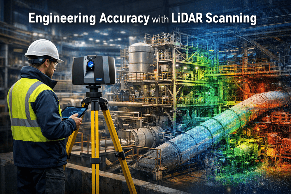
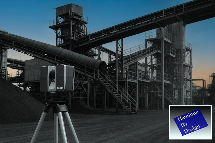
Modern engineering projects increasingly rely on accurate digital representations of existing infrastructure before design, fabrication, or modification begins. One of the most powerful technologies enabling this is LiDAR scanning (Light Detection and Ranging).
At Hamilton By Design, LiDAR scanning is used to capture engineering-grade point cloud data of industrial facilities, mining infrastructure, processing plants, and mechanical systems across Australia.
Understanding the accuracy of LiDAR scanning is essential for engineers, project managers, and asset owners when planning upgrades or modifications to existing facilities.
What is LiDAR Scanning?
LiDAR scanning works by emitting thousands of laser pulses per second. These pulses strike surrounding surfaces and return to the scanner, allowing precise calculation of distance.
The result is a dense three-dimensional point cloud that captures the exact geometry of an environment.
The accuracy of LiDAR scanning depends on several factors including the scanner type, range to the object, scanning environment, and control methodology.
Typical engineering-grade terrestrial LiDAR systems achieve:
Parameter
Typical Accuracy
Scanner measurement accuracy
±1 mm to ±3 mm
Registered scan network accuracy
±2 mm to ±6 mm
Large plant scan accuracy
±5 mm to ±10 mm
For most industrial engineering applications, this level of accuracy is more than sufficient to support:
• Structural steel modifications • Pipework routing and tie-ins • Mechanical equipment installation • Conveyor and materials handling upgrades • Plant shutdown engineering works
Factors That Affect LiDAR Accuracy
Although LiDAR scanning can achieve extremely high accuracy, several practical factors influence final results.
Scan Resolution
Higher resolution scanning increases the number of measured points and improves detail, but also increases processing time and file size.
Distance to Target
Accuracy decreases slightly as the distance between the scanner and the object increases. Industrial scanning programs typically maintain distances between 5–40 metres.
Scan Registration
Multiple scans must be aligned together to form a complete dataset. Proper registration and survey control ensures that the final point cloud remains accurate across large areas.
Surface Conditions
Highly reflective, transparent, or moving surfaces may introduce noise or missing data within the scan.
Why Accuracy Matters for Engineering Projects
Engineering projects often involve modifying existing assets that may have been constructed decades ago.
Original drawings may be missing, outdated, or inaccurate.
By capturing true existing conditions, LiDAR scanning reduces risk during design and construction.
LiDAR Scanning for Mining and Industrial Infrastructure
Industries where LiDAR scanning is particularly valuable include:
• Mining and mineral processing • Water and wastewater facilities • Power generation plants • Heavy manufacturing facilities • Materials handling systems
At Hamilton By Design, scanning is commonly used to support:
This allows engineers to design modifications directly against the existing environment, dramatically reducing project risk.
Conclusion
LiDAR scanning has become an essential tool for modern engineering projects, providing millimetre-level accuracy when capturing existing infrastructure.
When combined with experienced engineering workflows, LiDAR enables faster, safer, and more reliable plant upgrades.
At Hamilton By Design, we specialise in transforming high-accuracy LiDAR data into practical engineering models and design solutions for mining, industrial, and infrastructure projects.
Need LiDAR Scanning for Your Project?
Hamilton By Design provides engineering-grade 3D laser scanning services across Australia to support plant upgrades, shutdown projects, and infrastructure modifications.
Industrial facilities rarely stay the same for long. As plants evolve through expansions, equipment upgrades, shutdown projects, and process improvements, engineers must first answer a critical question:
What does the plant actually look like today?
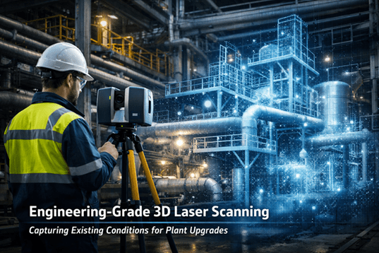
Capturing accurate existing conditions is the first step in any successful engineering upgrade. Without reliable information about current structures, pipework, equipment, and clearances, even the best engineering design can result in costly clashes, rework, and project delays.
Modern engineering teams increasingly rely on engineering-grade 3D laser scanning to document industrial facilities before modifications begin.
Why Existing Conditions Matter in Industrial Engineering
Many mining plants, process plants, and industrial facilities have evolved over decades. Equipment may have been modified multiple times, undocumented changes may exist, and original drawings often no longer reflect the actual plant configuration.
Traditional measurement methods such as tape measures, sketches, or manual surveys can introduce errors and often miss important details. Laser scanning provides a more reliable solution by capturing millions of accurate spatial measurements of the facility.
By documenting the true “as-built” condition of the plant, engineers can confidently plan upgrades, tie-ins, or equipment replacements.
How 3D Laser Scanning Captures Industrial Facilities
3D laser scanning uses LiDAR technology to measure distances using laser pulses. Each pulse reflects off surfaces such as pipework, structures, conveyors, and equipment, generating millions of spatial data points known as a point cloud.
This point cloud forms a highly accurate digital representation of the plant that engineers can use for design, modelling, and analysis.
Typical workflow:
Site Planning Engineers identify critical areas that require scanning such as process lines, structural steel, equipment interfaces, or congested pipework zones.
Laser Scanning on Site Laser scanners capture millions of measurements from multiple positions around the facility.
Point Cloud Registration Individual scans are aligned to create a unified 3D dataset representing the entire plant area.
Engineering Modelling Engineers convert the point cloud into CAD models, layouts, or detailed equipment geometry.
Design Integration The captured plant geometry is used as the foundation for upgrades, modifications, or shutdown planning.
Reducing Risk During Plant Upgrades
One of the biggest risks in industrial projects is unknown site conditions. Pipe clashes, structural conflicts, and spatial constraints often appear only after fabrication begins.
Laser scanning dramatically reduces these risks by providing accurate geometry for the design team.
Benefits include:
• Accurate equipment placement and tie-in design • Clash detection before fabrication • Reduced site measurement time • Improved shutdown planning • Better communication between engineers and site teams
Accurate scan data also allows engineers to validate clearances and design solutions before installation, improving the chances of first-time fit during shutdown work.
Supporting Mining Shutdown Projects
Shutdowns are often the only window available to upgrade equipment in operating plants. Engineering teams must complete installation work quickly, leaving little tolerance for design errors.
By scanning plant areas prior to the shutdown, engineers can:
The resulting digital models also contribute to digital twins, asset management, and long-term maintenance planning within industrial facilities.
Laser Scanning Services Across Australia
Hamilton By Design provides engineering-grade laser scanning services across Australia, supporting mining, heavy industry, infrastructure, and process plants.
As industrial facilities become more complex, accurate digital capture of existing conditions is becoming a standard engineering requirement.
Laser scanning allows engineers to move beyond incomplete drawings and manual measurements toward data-driven plant design. By combining scan data with engineering modelling, teams can design upgrades faster, reduce risk, and deliver projects with greater confidence.
For organisations planning plant upgrades, shutdowns, or infrastructure improvements, capturing existing conditions with engineering-grade scanning is no longer optional — it is a critical step toward successful project delivery.
In the world of industrial engineering and brownfield upgrades, there is a dangerous word: Assumption.
Whether you are upgrading a CHPP, modifying a conveyor system, or retrofitting a processing plant, your project is only as strong as the data it’s built on. At Hamilton By Design, we’ve seen how “near enough” measurements lead to costly rework, extended shutdowns, and safety risks.
The solution? Moving from manual estimation to Engineering-Led LiDAR Scanning.
The High Cost of Inaccurate Information
Traditional “manual” documentation—using tape measures, spirit levels, and old 2D drawings—is prone to human error. In complex industrial environments, missing a single pipe interference or a slight structural lean by even 20mm can mean a prefabricated component won’t fit during a critical shutdown.
When site data is inaccurate:
Fabrication fails: Parts arrive on-site but don’t clear existing structures.
Costs skyrocket: Emergency “hot works” and on-site modifications blow out budgets.
Safety is compromised: Forced fits can create structural stress and unforeseen hazards.
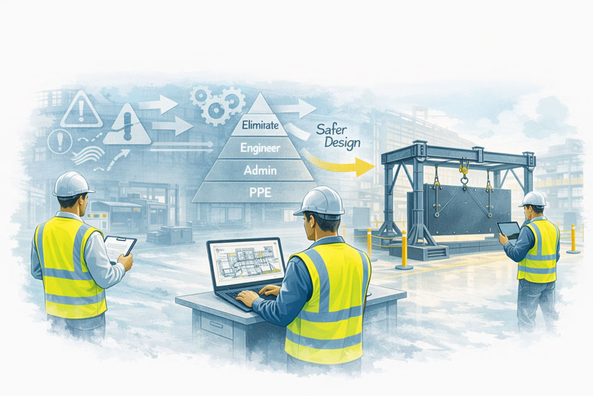
Why Geometry is the Foundation of Engineering
Geometry isn’t just about shapes; it’s about the spatial relationship between every asset on your site. Accurate geometry is critical because:
Clash Detection: It allows us to identify “soft” and “hard” clashes in a digital environment before a single bolt is turned.
Structural Integrity: Precise angles and load-path documentation ensure that new modifications integrate safely with legacy steelwork.
Efficiency: Understanding the exact volume, pitch, and clearance of a site allows for “First-Time-Fit” engineering.
LiDAR Scanning: The Simple Solution for Complex Reality
LiDAR (Light Detection and Ranging) removes the guesswork. A LiDAR scanner emits millions of laser pulses per second to create a Point Cloud—a highly accurate 3D digital “twin” of your facility.
Why it’s a game-changer:
Speed: Capture entire plant rooms or structural towers in minutes, not days.
Safety: We can scan hazardous or hard-to-reach areas from a safe distance, removing the need for scaffolding just to take a measurement.
Completeness: Unlike a manual survey that only measures what you think is important, LiDAR captures everything in its line of sight, providing context you might need later.
The “Silent Witness”: Point Clouds in Legal and Insurance Cases
Beyond design, point cloud data serves as an indisputable “source of truth” in legal and insurance contexts. Because a scan is a timestamped, millimeter-accurate record of reality, it is increasingly used in:
Construction Disputes: Providing evidence of “as-built” conditions vs. “as-designed” plans to settle variations or defect claims.
Incident Investigation: In the event of a structural failure or site accident, a pre-existing or post-incident scan provides an objective 3D map for forensic analysis.
Asset Accountability: Scans serve as a permanent record of site conditions before a contractor begins work, protecting owners and contractors alike from liability.
The Hamilton By Design Difference
We don’t just provide “data.” We provide engineering-led reality capture. Because we are engineers and fabricators ourselves, we know what to look for when we scan. We don’t just give you a cloud of dots; we translate that data into usable CAD models and fabrication-ready drawings that respect Australian Standards (like AS 4324.1).
Stop guessing and start building with confidence. [Contact the Hamilton By Design team today] to discuss how our LiDAR scanning services can de-risk your next project.
Engineering-Led LiDAR & Mechanical Design for Mining | Mount Isa QLD
Hamilton By Design provides engineering-led LiDAR scanning and mechanical design services for mining and heavy-industry operations in Mount Isa and North West Queensland. Our work supports brownfield assets, live operating plant, and shutdown-driven projects where accuracy, risk control, and constructability are critical.
This is not survey-only scanning. We integrate engineering judgement with high-accuracy reality capture to deliver fabrication-ready, fit-first-time outcomes for base metals operations, processing plants, and heavy industrial infrastructure in remote and operationally constrained environments.
Engineering-Led LiDAR for North West Queensland Mining
Mining operations in Mount Isa face unique challenges:
Remote location and logistics constraints
Legacy infrastructure with limited as-built documentation
Continuous operations with minimal downtime
High consequence of rework during shutdowns
Our engineering-led LiDAR approach is designed specifically for operating mine sites where assumptions carry cost, safety, and schedule risk.
Integrated Scan-to-Engineering Workflow
We deliver a single, accountable workflow tailored to remote mining operations:
On-site LiDAR scanning performed by engineers familiar with mining access, safety, and operational constraints
Engineering-grade point-cloud processing aligned to modelling tolerances and fabrication requirements
Mechanical and structural CAD modelling developed directly from scan data
Fabrication-ready drawings suitable for workshop manufacture and site installation
Engineering support through fabrication, installation, and commissioning
This approach reduces interface risk between scanning, design, fabrication, and construction — particularly important in remote regions where rework is costly.
Mining & Heavy Industry Applications in Mount Isa
Brownfield Engineering & Existing Assets
Mount Isa operations rely heavily on long-life assets that have evolved over decades. We support brownfield engineering where:
Original drawings are incomplete or unavailable
Multiple generations of plant modifications exist
Clearances, interfaces, and access are critical
LiDAR provides accurate existing-condition data, while engineering oversight ensures the information is applied correctly during design and verification.
Shutdown-Driven Projects
Shutdown windows in remote operations are limited and tightly managed.
Our work supports shutdown success by:
Capturing existing conditions before outages
Eliminating site measurement during shutdowns
Verifying interfaces, access, and constructability
Reducing fabrication and installation risk
Pre-validated designs improve safety, schedule certainty, and execution quality.
Processing Plants & Bulk Materials Handling
Mining operations in Mount Isa include complex processing and materials-handling infrastructure.
Our engineering-led LiDAR services support:
Conveyors and transfer stations
Hoppers, bins, and chutes
Crushers, screens, and feeders
Walkways, platforms, and guarding upgrades
Accurate scan-to-CAD workflows enable confident redesign, replacement, and compliance upgrades in operating plants.
Heavy Plant & Industrial Equipment
We support projects involving large and complex equipment where traditional measurement methods are unsafe or impractical, including:
Fixed and mobile processing plant
Large structural steel assemblies
Access systems and maintenance platforms
Engineering-led scanning ensures interfaces, envelopes, and installation constraints are understood before fabrication begins.
Risk Management for Remote Mining Projects
In remote mining environments, risk is amplified by distance, logistics, and limited tolerance for error.
Our approach reduces risk by:
Removing reliance on outdated or assumed information
Capturing accurate existing conditions prior to design
Identifying clashes and access constraints early
Reducing site rework and hot works
Supporting safer shutdown execution
Risk is managed upstream, where changes are cheapest and safest to implement.
What Makes Our Approach Different
Engineer-led LiDAR scanning, not technician-only capture
Mechanical and structural engineering capability in-house
Mining and heavy-industry focus
Brownfield and shutdown experience
Single point of responsibility from scan through to design output
Typical Deliverables
Depending on project scope, deliverables may include:
Registered point-cloud datasets
Engineering-grade 3D CAD models
Mechanical and structural drawings
Interface and clearance verification
Fabrication and installation documentation
All deliverables are developed with fabrication, installation, and operational use in mind.
Who We Support
Our services support:
Base metals and mining asset owners
Processing plant operators
Maintenance and shutdown teams
Project engineers and managers
Fabricators and constructors operating in North West Queensland
We work directly with asset owners or as part of multi-disciplinary project teams.
Talk to an Engineer
If you are planning:
A brownfield upgrade
A shutdown-driven project
Processing plant modifications
Conveyor or heavy plant upgrades
Hamilton By Design can support your project in Mount Isa and North West Queensland with engineering-led LiDAR scanning and mechanical design.
Contact us to discuss your site, constraints, and project objectives.
Unlocking Accuracy, Safety and Efficiency for Critical Infrastructure
The Hunter Valley is home to some of Australia’s most significant power generation assets. These power stations — many of which have operated for decades — supply energy to mining operations, manufacturing facilities, regional communities and industries throughout New South Wales. As these plants age and undergo continual maintenance, upgrades and redevelopment, the importance of accurate, reliable and safe measurement methods becomes increasingly critical.
Traditionally, engineers and maintenance teams have relied on manual measurements, outdated drawings or partial documentation to plan upgrades or execute shutdown work. But in complex, congested and ageing plant environments, this introduces risks, delays and expensive rework.
This is why 3D LiDAR scanning in Hunter Valley power stations has emerged as one of the most valuable tools for modern asset management, engineering and maintenance planning. LiDAR provides a millimetre-accurate digital snapshot of real-world conditions, enabling smarter, safer and more predictable project outcomes.
This article explores the benefits, applications, and pros and cons of 3D LiDAR scanning and explains why Hunter Valley power stations stand to gain significantly from adopting this technology.
Why Power Stations Need Accurate As-Built Data
Power stations are among the most complex industrial facilities in Australia. Over decades of operation, they experience:
Structural deformation
Settlement and movement
Corrosion and wear
Numerous undocumented modifications
Equipment realignments
Tight access restrictions
Ageing steelwork and infrastructure
In these environments, original construction drawings rarely match reality. As a result, engineers planning upgrades, shutdowns or replacements often face:
Inaccurate interface points
Misaligned structures
Unpredictable installation conditions
High rework costs
Safety delays
Poor shutdown timing
3D LiDAR scanning offers a precise, digital representation of the site, giving engineers the confidence they need to design upgrades accurately and eliminate guesswork.
The Benefits of 3D LiDAR Scanning for Hunter Valley Power Stations
1. Unmatched Measurement Accuracy for Complex Assets
A power station contains thousands of interconnected components:
Boilers
Turbines
Structural platforms
Pipe networks
Pressure vessels
Ducting systems
Conveyor bridges
Cooling towers
Electrical cabinets
Steel supports
Capturing these geometries manually is nearly impossible.
3D LiDAR scanning provides millimetre-level accuracy across enormous plant areas, allowing engineers to:
Create precise as-built models
Validate structural alignment
Check pipe routes and clearances
Identify interferences
Understand deformation over time
Design new works based on real geometry
This level of data is invaluable for maintaining safe and compliant power-generation operations.
2. Major Safety Improvements
Power stations present significant safety risks:
High-voltage environments
Confined spaces
Elevated platforms
Hot surfaces
Restricted access
Operational machinery
Manual measurement often requires workers to climb structures, enter hazardous zones or physically reach difficult areas.
3D LiDAR scanning dramatically reduces risk by:
Capturing data from safe distances
Eliminating the need for repeated access
Reducing time in hazardous zones
Minimising interaction with live equipment
For Hunter Valley power stations with strict safety requirements, this is a major benefit.
3. Reduced Shutdown Duration and Cost
Shutdowns are among the most expensive events for power-generation facilities. Every hour counts.
With 3D LiDAR scanning:
Engineers define accurate scopes before shutdown
Fabricators receive precise data and cut steel correctly
Digital fit checks identify issues early
Installation is faster and smoother
Delays due to bad measurements are eliminated
This leads to shorter outages, safer work and fewer unexpected problems.
4. Supports Engineering, Design and Structural Integrity Works
Power stations frequently require:
Boiler upgrades
Turbine area modifications
Ducting and flue replacements
Pipework rerouting
Cooling-system upgrades
Structural strengthening
Platform and walkway replacements
Electrical equipment relocations
All of these tasks depend on accurate geometry.
3D LiDAR scanning supports engineering teams by providing:
Reference geometry for load calculations
Verified connection points
True alignment data
Accurate slope and deflection measurements
High-resolution drawings and 3D models
This ensures engineering decisions are made using verified, real-world information.
5. Perfect for Brownfield and Congested Environments
Power stations are some of the most complex brownfield assets in the industrial landscape. They contain layers of modifications, years of retrofits and areas where access is extremely limited.
3D LiDAR scanning excels at capturing:
Tight clearances
Overlapping structures
Equipment clusters
Interconnected pipes
Hard-to-reach surfaces
This makes it ideal for planning:
New platforms
Replacement ducting
Pipe realignments
Structural upgrades
Asset lifecycle extensions
The result: fewer surprises during installation.
6. Better Collaboration Between Teams
Power stations typically involve:
Maintenance teams
OEMs
Engineering consultants
Fabricators
Shutdown managers
Safety personnel
Project delivery teams
3D LiDAR scanning enables everyone to work from the same digital truth.
Point clouds and 3D models allow:
Remote site understanding
Clear communication
Digital reviews instead of repeated site visits
Improved planning alignment
For Hunter Valley projects involving multiple contractors, this significantly boosts performance.
Pros and Cons of 3D LiDAR Scanning
Like any technology, LiDAR has strengths and limitations. Understanding both helps power station operators make informed decisions.
Pros
✔ Extremely high accuracy
Millimetre precision for large and complex areas.
Fast data capture
Reduces time spent in hazardous areas.
Clear visibility of congested spaces
Captures geometry that traditional methods miss.
Enhances engineering confidence
Designers base work on verified conditions.
Reduces installation rework
Fabrication matches the real site exactly.
Supports digital engineering workflows
Perfect input for CAD, BIM, simulation and modelling.
Safer measurement practices
Less climbing, reaching and confined-space entry.
Cons
Requires skilled interpretation
Point cloud data must be processed by trained technicians or engineers.
Reflective or transparent surfaces can create challenges
Requires technique or matte marking in some areas.
Upfront cost may seem higher
But it eliminates far greater downstream costs in rework and shutdown delays.
Despite these considerations, LiDAR scanning remains the most cost-effective measurement tool for power station environments.
Why Hunter Valley Power Stations Benefit More Than Most
The Hunter Valley industrial landscape presents unique challenges:
Ageing energy infrastructure
Multiple retrofits and undocumented modifications
Extremely tight maintenance windows
Harsh environmental conditions
Congested structures with difficult access
High safety standards
Heavy reliance on local fabrication accuracy
3D LiDAR scanning Hunter Valley power stations provides the one thing these facilities need most: confidence.
Confidence in measurements. Confidence in fabrication. Confidence during shutdowns. Confidence in engineering decisions. Confidence in safety performance.
Few regions stand to gain more from LiDAR than the Hunter.
Hamilton By Design: Supporting Hunter Valley Power Stations with Advanced LiDAR Solutions
Hamilton By Design brings together:
Engineering expertise
On-site scanning capability
CAD modelling and drafting
Fabrication-ready documentation
Digital fit-checking and clash detection
Mechanical and structural design experience
We understand the complex realities of power-station environments, and we deliver precise, reliable and engineering-ready digital data for:
Boiler upgrades
Turbine hall modifications
Structural replacements
Pipe rerouting
Platform and access upgrades
Ducting and flue modifications
Cooling tower projects
Balance-of-plant improvements
Every model, point cloud and drawing is produced with installation success and fabrication accuracy in mind.
Conclusion: 3D LiDAR Scanning is the New Standard for Hunter Valley Power Stations
As the Hunter Valley transitions into a future of renewable generation, asset extension and industrial redevelopment, 3D LiDAR scanning stands out as a technology that delivers real, immediate value.
It improves safety. It increases accuracy. It reduces rework. It enables better engineering. It shortens shutdowns. It lowers project risk.
Power stations across the Hunter Valley rely on critical, ageing and highly complex infrastructure — infrastructure that demands accurate, reliable digital measurement.
Hamilton By Design is proud to support the region with advanced laser scanning technologies that empower engineers, fabricators, supervisors and project managers to work smarter, safer and more efficiently.
To provide the best experiences, we use technologies like cookies to store and/or access device information. Consenting to these technologies will allow us to process data such as browsing behaviour or unique IDs on this site. Not consenting or withdrawing consent, may adversely affect certain features and functions.
Functional
Always active
The technical storage or access is strictly necessary for the legitimate purpose of enabling the use of a specific service explicitly requested by the subscriber or user, or for the sole purpose of carrying out the transmission of a communication over an electronic communications network.
Preferences
The technical storage or access is necessary for the legitimate purpose of storing preferences that are not requested by the subscriber or user.
Statistics
The technical storage or access that is used exclusively for statistical purposes.The technical storage or access that is used exclusively for anonymous statistical purposes. Without a subpoena, voluntary compliance on the part of your Internet Service Provider, or additional records from a third party, information stored or retrieved for this purpose alone cannot usually be used to identify you.
Marketing
The technical storage or access is required to create user profiles to send advertising, or to track the user on a website or across several websites for similar marketing purposes.