Trimble Scanners vs FARO Scanners |Which Technology Is Right for Your Project?
The laser scanning industry has evolved significantly over the last decade. Modern reality capture systems can document entire buildings, processing plants, infrastructure assets, mining operations, and manufacturing facilities with remarkable speed and accuracy.
Two of the most recognised names in the terrestrial laser scanning market are Trimble and FARO Technologies.
Both manufacturers produce capable scanning equipment, but they were developed with different target markets and project requirements in mind.
The question is not necessarily which scanner is better.
The real question is:
Which scanner is best suited to the type of project you are trying to complete?
At Hamilton By Design, we focus primarily on engineering, industrial facilities, manufacturing plants, mining infrastructure, reverse engineering, and Scan-to-CAD projects. Because of this, our requirements differ significantly from those of surveyors, construction layout teams, BIM consultants, or mobile mapping providers.
This article explains where Trimble systems excel, where FARO systems excel, and which technology may be the best fit for your application.
Understanding Laser Scanning Objectives
Before comparing scanner brands, it is important to understand the purpose of the project.
Most scanning projects fall into one of the following categories:
Surveying
Surveyors typically require:
- Geospatial accuracy
- Coordinate control
- GIS integration
- Large-scale topographic surveys
- Infrastructure corridors
- Road and rail mapping
Construction
Construction projects often require:
- BIM coordination
- Progress monitoring
- Clash detection
- Layout verification
- Digital twins
Engineering
Engineering projects typically require:
- Mechanical design
- Reverse engineering
- Fabrication drawings
- Plant modifications
- Structural steel detailing
- Pipework design
Asset Management
Asset owners often require:
- Digital records
- Facility management
- Lifecycle documentation
- Maintenance planning
Different scanners have been optimised for different objectives.
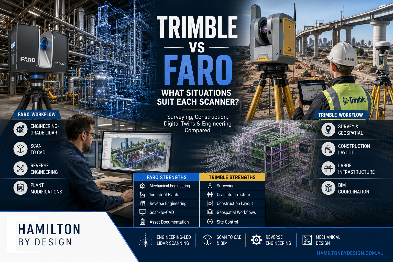
Trimble Overview
Trimble has built its reputation through:
- Surveying equipment
- GPS systems
- Construction technology
- Machine control
- Geospatial software
- BIM workflows
Their scanning solutions are designed to integrate into broader construction and survey ecosystems.
Popular Trimble scanners include:
Trimble X7
A compact scanner targeting:
- Surveyors
- Construction professionals
- BIM teams
Trimble X9
A higher-performance evolution of the X7 featuring:
- Greater range
- Faster scanning
- Improved workflows
Trimble SX12
A hybrid scanner and total station offering:
- Survey functionality
- Laser scanning
- High-precision measurement
Trimble MX Series
Vehicle-mounted mobile mapping systems designed for:
- Roads
- Railways
- Utility corridors
- City modelling
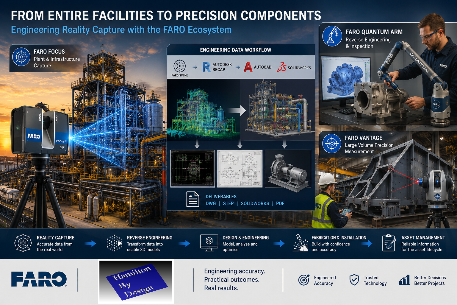
FARO Overview
FARO Technologies has historically focused on:
- Industrial measurement
- Manufacturing
- Metrology
- Quality control
- Engineering documentation
Their scanners are widely used for:
- Industrial plants
- Refineries
- Manufacturing facilities
- Reverse engineering
- Scan-to-CAD
Popular FARO systems include:
FARO Focus S70
Optimised for:
- Engineering projects
- Indoor scanning
- Plant scanning
- Industrial facilities
FARO Focus Premium
Provides:
- Extended range
- Faster scan speeds
- Improved HDR imaging
FARO Orbis
A mobile scanning system designed for:
- Walking surveys
- Rapid reality capture
- Large facilities
FARO Quantum Arm
A portable coordinate measuring machine (CMM) used for:
- Metrology
- Manufacturing inspection
- Reverse engineering
Accuracy Comparison
Accuracy is often the first specification people examine.
However, accuracy must be considered within the context of the project.
Trimble
Trimble systems generally provide excellent accuracy for:
- Surveying
- Construction
- Geospatial projects
Their workflows place strong emphasis on:
- Coordinate systems
- Site control
- Survey networks
This makes them highly attractive to surveyors and construction teams.
FARO
FARO scanners have traditionally focused on:
- Engineering accuracy
- Mechanical systems
- Industrial facilities
When documenting:
- Pipework
- Structural steel
- Mechanical equipment
- Fabrication interfaces
FARO scanners have established a strong reputation for producing dense, high-quality point clouds suitable for engineering design.
Range Comparison
Range requirements vary significantly between projects.
Trimble Range Strengths
Trimble performs exceptionally well when scanning:
- Roads
- Bridges
- Rail corridors
- Civil infrastructure
- Large construction sites
These environments benefit from long-range scanning and integration with survey control.
FARO Range Strengths
The FARO Focus series performs extremely well in:
- Buildings
- Processing plants
- Manufacturing facilities
- Mechanical rooms
- Industrial environments
For many engineering projects, scanners are positioned:
- 5–40 metres from equipment
- 5–50 metres from structures
In these situations, extremely long-range scanning is often unnecessary.
Mobile Mapping Comparison
One of the biggest changes in recent years has been the growth of mobile mapping.
Trimble Mobile Mapping
Trimble has invested heavily in:
- Vehicle-mounted systems
- Corridor mapping
- Geospatial workflows
Ideal applications include:
- Road surveys
- Utility networks
- Large infrastructure projects
FARO Orbis
The FARO Orbis allows operators to:
- Walk through facilities
- Capture large areas quickly
- Reduce field time
Applications include:
- Warehouses
- Airports
- Shopping centres
- Large industrial facilities
The advantage is speed.
The limitation is that mobile systems generally require more processing and validation than static scanning.
Registration Workflows
Registration is the process of combining scans into a unified point cloud.
Trimble Registration
Trimble provides strong registration tools aimed at:
- Survey workflows
- Construction workflows
- BIM projects
Their ecosystem integrates effectively with coordinate control networks.
FARO Registration
FARO’s software platform, particularly FARO SCENE, has become a well-established standard for industrial registration.
Strengths include:
- Target-based registration
- Cloud-to-cloud registration
- Engineering workflows
- Industrial documentation
For plant environments, SCENE remains a highly capable platform.
Surveying Applications
Where Trimble excels:
Large Survey Projects
Examples include:
- Highways
- Rail networks
- Airports
- Utility corridors
Trimble’s heritage in surveying makes these projects a natural fit.
Construction Control
Projects requiring:
- Set-out
- Coordinate control
- Site surveys
benefit from Trimble’s integrated ecosystem.
Engineering Applications
Where FARO excels:
Reverse Engineering
Examples include:
- Pumps
- Conveyors
- Structural steel
- Mechanical assemblies
The ability to create engineering-grade point clouds is critical.
Plant Modification Projects
Examples include:
- Pipe rerouting
- Chute redesign
- Conveyor upgrades
- Equipment replacement
The scanner becomes the foundation of the design process.
Fabrication Projects
Fabrication projects often require:
- As-built verification
- Fit-up confirmation
- Clash detection
FARO scanners are commonly used for these tasks.
Mining Industry Comparison
Mining presents unique challenges.
Projects often involve:
- Dust
- Restricted access
- Complex plant layouts
Trimble in Mining
Common uses:
- Site surveys
- Civil infrastructure
- Haul roads
- Tailings facilities
FARO in Mining
Common uses:
- CHPP plants
- Conveyors
- Crushers
- Structural steel
- Transfer stations
Engineering teams frequently prefer detailed plant scans for design work.
Scan-to-CAD Workflows
This is where many engineering firms spend most of their time.
The objective is not merely collecting data.
The objective is producing:
- CAD models
- Drawings
- Fabrication packages
Trimble Workflow
Often integrated into:
- BIM
- Construction
- Survey deliverables
FARO Workflow
Frequently integrated into:
- AutoCAD
- SolidWorks
- Inventor
- Navisworks
- Plant design software
For engineering-driven Scan-to-CAD workflows, FARO has become particularly popular.
Metrology Comparison
This category creates the biggest distinction between the two companies.
Trimble
Trimble’s focus is largely:
- Geospatial
- Construction
- Infrastructure
FARO
FARO offers dedicated metrology products such as the:
FARO Quantum Arm
Applications include:
- Manufacturing inspection
- Tooling verification
- Reverse engineering
- Precision measurement
Measurement uncertainty can be measured in fractions of a millimetre.
This is an entirely different category from traditional terrestrial scanning.
Digital Twin Applications
Both systems can contribute to digital twin projects.
Trimble Advantages
Particularly strong when projects involve:
- BIM integration
- Construction workflows
- Asset management
FARO Advantages
Particularly strong when projects involve:
- Engineering assets
- Industrial plants
- Manufacturing facilities
Cost Considerations
Scanner purchase decisions should not be based solely on hardware cost.
Consider:
- Software
- Training
- Registration
- Processing
- Deliverables
The cheapest scanner often becomes the most expensive solution if it fails to meet project requirements.
When Trimble Is the Better Choice
Choose Trimble when your primary focus is:
Surveying
- Geospatial control
- Land surveying
- Corridor mapping
Construction
- BIM coordination
- Progress monitoring
- Site verification
Infrastructure
- Roads
- Rail
- Utilities
Mobile Mapping
- Vehicle-based capture
- Large-area mapping
When FARO Is the Better Choice
Choose FARO when your primary focus is:
Mechanical Engineering
- Equipment design
- Reverse engineering
- Plant modifications
Industrial Facilities
- Refineries
- Processing plants
- Manufacturing sites
Structural Steel
- Existing structure capture
- Fabrication verification
Scan-to-CAD
- AutoCAD workflows
- SolidWorks workflows
- Inventor workflows
Metrology
- Inspection
- Precision measurement
- Manufacturing verification
The Hamilton By Design Perspective
At Hamilton By Design, our work typically involves:
- Mining plants
- Manufacturing facilities
- Process equipment
- Structural steel
- Conveyors
- Chutes
- Pipework
- Mechanical upgrades
We are generally not:
- Surveying housing estates
- Mapping road corridors
- Building GIS databases
- Performing civil infrastructure surveys
Our goal is usually to answer engineering questions such as:
- Will the new chute fit?
- Can the conveyor be upgraded?
- Does the pipe clash?
- Can the fabricated structure be installed?
- What does the existing plant actually look like?
For those objectives, the combination of:
- FARO Focus S70
- FARO SCENE
- AutoCAD
- SOLIDWORKS
provides an efficient engineering workflow.
Conclusion
Neither Trimble nor FARO is universally better.
They were developed to solve different problems.
Trimble is exceptionally strong in:
- Surveying
- Construction
- Geospatial workflows
- Infrastructure mapping
- Coordinate control
FARO is exceptionally strong in:
- Mechanical engineering
- Industrial facilities
- Reverse engineering
- Scan-to-CAD
- Metrology
- Plant modification projects
If your objective is mapping kilometres of roadway, Trimble may be the logical choice.
If your objective is redesigning a conveyor transfer chute, replacing a pump station, upgrading a processing plant, or creating fabrication-ready CAD models from existing infrastructure, FARO is often the more suitable engineering-focused solution.
The best scanner is not the one with the longest specification sheet. The best scanner is the one that produces the deliverable your project actually needs. For many industrial engineering projects, that deliverable is not a point cloud—it is an accurate model, drawing package, fabrication detail, or engineered solution built from the scan data.