3D Laser Scanning on the Central Coast NSW: From Point Cloud to Build-Ready CAD

From laser scan to CAD: point cloud of Avoca Beach foreshore assets converted into build-ready engineering drawings.

Accurate site data is the difference between a smooth upgrade and a shutdown full of surprises.
At Hamilton By Design, we provide engineering-grade 3D laser scanning (LiDAR) across the Central Coast NSW โ€” including Wyong, Gosford, Tuggerah and Somersby โ€” and convert that data into design-ready CAD and 3D models for industrial and building projects.

If youโ€™re planning equipment upgrades, new conveyors, structural modifications or fabrication packages, scanning gives you reliable geometry before steel is cut or contractors mobilise.


Who this service is for

Our Central Coast scanning services are typically used by:

  • Project engineers planning plant or building upgrades
  • Maintenance teams preparing shutdown scopes
  • Fabricators needing accurate tie-in dimensions
  • Asset owners updating as-built records
  • Consultants managing brownfield modifications

If drawings donโ€™t match reality โ€” or donโ€™t exist at all โ€” scanning becomes the safest and fastest way to establish an accurate baseline.


3D LiDAR scanning services on the Central Coast providing engineering-grade laser scanning, point cloud capture, scan-to-CAD modelling and industrial reality capture for infrastructure and industrial projects.
Drafting services on the Central Coast providing engineering drawings, fabrication detailing, as-built documentation, reverse engineering and CAD drafting for industrial and infrastructure projects.
Mechanical engineering services on the Central Coast providing industrial design, plant inspections, pump calculations, reverse engineering and engineering support for manufacturing, infrastructure and heavy industry projects.

From scan to CAD: turning site data into buildable designs

A point cloud on its own doesnโ€™t solve project risk.
What matters is converting scan data into usable engineering outputs.

Our workflow supports:

  • 2D CAD drawings (plans, sections, elevations)
  • 3D CAD models for layout and clash detection
  • Tie-in modelling for new equipment and structures
  • Verification of clearances and access zones
  • Fabrication-ready geometry for workshop drawings

This scan-to-CAD process is especially valuable for retrofit projects where new components must integrate with existing assets.


Why 3D scanning is ideal for brownfield upgrades

Most Central Coast industrial and commercial sites are brownfield environments โ€” tight access, legacy equipment and undocumented modifications.

3D laser scanning helps to:

  • Reduce site re-visits and manual re-measuring
  • Identify clashes early in the design phase
  • Support off-site prefabrication
  • Shorten shutdown windows
  • Improve safety by limiting exposure time on site

When combined with engineering design, scanning becomes a risk-reduction tool, not just a survey method.
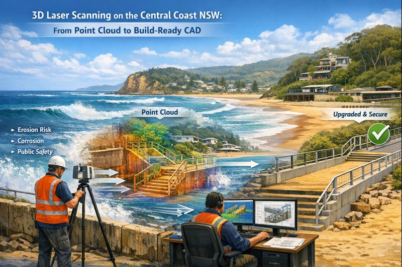

Engineer using 3D laser scanner at Avoca Beach foreshore with point cloud and CAD model showing upgrade of coastal stairs and seawall.

Typical Central Coast applications

We regularly support projects across:

Manufacturing and processing facilities

Equipment replacements, conveyor upgrades, access platform modifications.

Warehousing and logistics buildings

Structural modifications, mezzanine installations, services coordination.

Building services upgrades

Plantroom retrofits, mechanical services coordination, compliance verification.

Where Central Coast workshops are producing components for remote sites.


Local coverage: Wyong, Gosford, Tuggerah and Somersby

Being based on the Central Coast means we can support:

  • Rapid site capture
  • Staged scanning across multiple areas
  • Follow-up verification scans as scope evolves

That flexibility is important when designs change during live projects or shutdown preparation.


How accurate is engineering-grade LiDAR scanning?

Accuracy depends on site conditions and scope, but scanning provides consistent, repeatable geometry across complex environments that would be difficult and time-consuming to measure manually.

More importantly, it captures:

  • Spatial relationships
  • Real clearances
  • True equipment alignment

which are critical for retrofit engineering and fabrication.


When is scanning worth the investment?

Scanning typically delivers the best value when:

  • Drawings are outdated or incomplete
  • Fabrication must fit first time
  • Shutdown time is expensive
  • Access is restricted or unsafe
  • Multiple trades must coordinate in tight spaces

In many projects, preventing one major clash or rework cycle pays for the scan many times over.


Hamilton By Design logo displayed on a blue tilted rectangle with a grey gradient background

3D LiDAR scanning and 3D modelling service button โ€” laser scanner capturing a point cloud for engineering and CAD modelling
Mechanical engineering services

Planning an upgrade or fabrication project on the Central Coast?

If youโ€™re preparing for a shutdown, equipment upgrade or fabrication package across the Central Coast, early scanning can significantly reduce downstream risk.

Talk to Hamilton By Design about 3D laser scanning and point cloud to CAD support for your project.
Weโ€™ll help define the scope and deliverables that best suit your engineering and construction needs.
Name
Would you like us to arrange a phone consultation for you?
Address

3D Scanning in Greater Sydney NSW: From Point Cloud to BIM and Digital Twins for Smarter Projects

Engineers reviewing industrial design improvements in a mining fabrication workshop using engineering controls to reduce safety risks

3D Scanning in Greater Sydney NSW | Point Cloud to BIM & Digital Twins for Smarter Projects

Across Greater Sydney โ€” including industrial hubs like Blacktown โ€” asset owners and project teams are under increasing pressure to deliver upgrades, expansions, and maintenance projects with less downtime and lower risk. In congested brownfield environments, the biggest challenge is often not design โ€” it is knowing exactly what already exists on site.

This is where engineering-grade 3D laser scanning and point cloud to BIM workflows are transforming the way projects are planned and delivered across NSW.

At Hamilton By Design, we support industrial and infrastructure projects by converting accurate site data into practical engineering models that improve project certainty from concept through to construction.


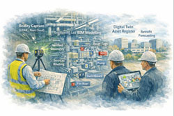
From point cloud to digital twin for lifecycle management of Sydney industrial and precinct assets

Why Accurate Site Data Matters in Greater Sydney

Many industrial facilities across Greater Sydney have evolved over decades. Services are added, conveyors rerouted, platforms extended, and temporary fixes become permanent. Unfortunately, drawings are rarely updated to reflect these changes.

For project managers, this creates risks such as:

  • Late discovery of clashes during installation
  • Unplanned scope changes and shutdown delays
  • Increased safety exposure during site rework
  • Cost overruns due to fabrication errors

Without accurate as-built data, project planning becomes reactive instead of proactive.

From 3D Scanning to Point Cloud to BIM

Using engineering-grade LiDAR scanners, we capture millions of spatial data points across entire facilities, producing highly accurate point clouds that represent the real-world geometry of structures, conveyors, services, and equipment.

These point clouds are then converted into:

  • BIM-ready 3D models
  • Fabrication-ready CAD geometry
  • Digital twins for ongoing asset management

This point cloud to BIM process allows project teams to design, coordinate, and review upgrades in a digital environment before any physical work begins.

For project management, this means fewer surprises and far better control over scope, schedule, and cost.

Digital Twin Creation for Ongoing Asset Management

Beyond individual projects, many asset owners in NSW are now adopting digital twins to manage facilities across their full lifecycle.

A digital twin created from accurate scan data allows teams to:

  • Visualise plant layouts remotely
  • Plan future upgrades with confidence
  • Improve maintenance access planning
  • Support safety reviews and training

In multi-site operations across Greater Sydney, digital twins also support consistent engineering standards and faster project scoping.

Rather than starting from scratch for every shutdown, project teams can build on a continually updated digital asset model.


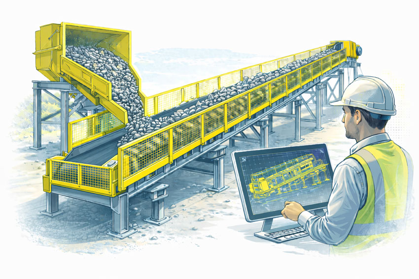
Bulk materials conveyor with compliant safety guarding at the hopper, tail end, and along the conveyor, shown with an engineer reviewing guarding design drawings.

Supporting Conveyor Design in Brownfield Environments

Conveyor systems remain critical to manufacturing, logistics, waste processing, and bulk materials handling facilities across Sydneyโ€™s western suburbs, including Blacktown and surrounding industrial precincts.

When conveyors are upgraded or rerouted, spatial constraints often drive:

  • Poor maintenance access
  • Compromised guarding
  • Clashes with services and structures

Scan-based conveyor modelling allows engineers to:

  • Verify belt paths, transfer points, and head drives
  • Design guarding that fits existing structures
  • Improve access platforms and walkways
  • Reduce installation time during shutdowns

For project managers, this directly translates into reduced safety risk and fewer installation delays.

Project Management Benefits of 3D Scanning

From a project delivery perspective, engineering-grade scanning supports:

  • More accurate scope definition
  • Better contractor coordination
  • Improved constructability reviews
  • Reduced variation claims
  • Safer installation planning

When all stakeholders are working from the same verified model, communication improves and decision-making becomes faster and more reliable.

This is particularly valuable on fast-tracked shutdown projects where every hour of downtime has a production cost.

Local Support Across Greater Sydney NSW

Hamilton By Design provides on-site 3D scanning, BIM modelling, and mechanical engineering support across Greater Sydney, including:

  • Blacktown
  • Western Sydney industrial precincts
  • Central Sydney infrastructure sites
  • Logistics and manufacturing facilities across NSW

As an engineering-led business, we integrate scanning directly into design, drafting, and fabrication support โ€” ensuring that digital models deliver practical, buildable outcomes.

Our focus is not just capturing data, but turning it into engineering solutions that reduce risk and improve project performance.

Turning Reality Capture into Project Confidence

Whether planning a conveyor upgrade, plant expansion, or long-term asset management strategy, accurate site data is the foundation of successful delivery.

By moving from point cloud to BIM and digital twins, project teams across Greater Sydney are gaining better visibility, stronger risk control, and far greater confidence in their project outcomes.


Hamilton By Design logo displayed on a blue tilted rectangle with a grey gradient background
3D LiDAR scanning and 3D modelling service button โ€” laser scanner capturing a point cloud for engineering and CAD modelling
Mechanical engineering services

Name
Would you like us to arrange a phone consultation for you?
Address
3D Scanning Sydney banner promoting engineering-grade 3D laser scanning, LiDAR scanning, and reality capture services by Hamilton By Design.
Mechanical Engineering Sydney banner with white text on a blue background representing Hamilton By Design's mechanical engineering services in Sydney.
Mechanical Drafting and 3D Modelling Sydney banner highlighting Hamilton By Design's CAD drafting, 3D modelling, and engineering design services in Sydney.

Mechanical Engineering | Structural Engineering


Hamilton By Design provides engineering-led 3D scanning, LiDAR scanning, mechanical engineering and digital engineering services throughout Sydney and Greater Sydney.

Explore our related Sydney services:


  • 3D Scanning Sydney โ€“ Engineering-grade terrestrial laser scanning, as-built surveys and point cloud capture for industrial, infrastructure and commercial projects.
  • Reality Capture Sydney โ€“ High-accuracy reality capture, digital twins, asset documentation and engineering-grade site verification.
  • Scan to CAD Sydney โ€“ Convert point cloud data into AutoCAD, SolidWorks, Inventor and other engineering-ready CAD deliverables.
  • Point Cloud Modelling Sydney โ€“ Engineering-grade point cloud processing, clash detection, as-built verification and 3D modelling.
  • Mechanical Engineering Sydney โ€“ Mechanical design, plant upgrades, materials handling systems, conveyors, chutes, platforms and engineering support.
  • Structural Drafting Sydney โ€“ Structural steel drafting, fabrication drawings, GA drawings, workshop detailing and as-built documentation.

Hamilton By Design supports projects throughout Sydney CBD, Parramatta, Liverpool, Penrith, Blacktown, Chatswood, Alexandria, Mascot, Newcastle and the Central Coast.


Blue banner graphic displaying the text "Point Cloud to CAD - Australia" in large white lettering, representing point cloud processing, scan-to-CAD conversion and digital engineering services across Australia.
Blue banner graphic displaying the text "Scan to CAD Sydney" in large white lettering, representing engineering-led point cloud to CAD conversion, LiDAR scanning and digital engineering services in Sydney.
Blue banner graphic displaying the text "Reality Capture Sydney - CBD" in large white lettering, representing engineering-led reality capture, LiDAR scanning and digital engineering services within Sydney CBD commercial buildings and infrastructure.

Digital Twin Creation & Long-Term Asset Management

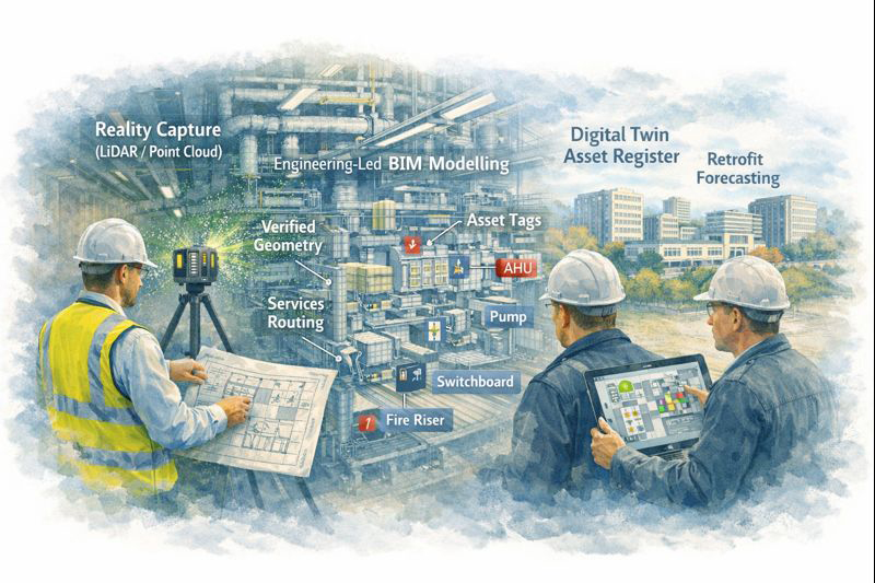
Digital twin created from LiDAR scanning showing asset tags and maintenance planning in industrial facility

Digital Twin Asset Management Sydney | Hamilton By Design

From Point Cloud to Digital Twin: Better Asset Control for Sydney Precincts

For asset owners and facilities managers across Greater Sydney and the Central Coast, accurate and accessible building data is no longer a luxury โ€” it is critical for maintenance planning, compliance, risk management, and future upgrades.

Yet many facilities still rely on incomplete drawings, outdated asset registers, or disconnected documentation spread across multiple systems.

At Hamilton By Design, we use high-accuracy 3D scanning and engineering-led modelling to create digital twins โ€” intelligent, data-rich representations of real facilities that support long-term asset management, not just one-off construction projects.


Why Traditional Building Records Fall Short

Over the life of a facility, buildings change constantly:

  • Services are upgraded or rerouted
  • Plant is replaced or relocated
  • Structural movement occurs over time
  • Temporary works become permanent
  • Documentation becomes fragmented or lost

As a result, asset owners are often forced to make decisions based on assumptions instead of verified data, increasing operational risk and lifecycle costs.

Digital twins replace uncertainty with measurable, current, and verifiable building intelligence.


What Is a Digital Twin โ€” and Why It Matters

A digital twin is more than a 3D model. It is a continuously usable digital representation of your physical asset that can support:

  • Asset lifecycle management
  • Maintenance planning and scheduling
  • Retrofit and upgrade forecasting
  • Compliance verification and reporting
  • Insurance documentation and risk mitigation

Using LiDAR and reality capture, we first create highly accurate point cloud data of your facility. This is then converted into structured engineering models and documentation, forming the foundation of a usable digital twin environment.


Supporting the Full Asset Lifecycle

Digital twins created by Hamilton By Design are designed to support decision-making across the entire life of an asset.

Asset Lifecycle Management

Digital twins provide a verified reference for:

  • Plant locations and access paths
  • Service routing and capacity
  • Structural geometry and tolerances
  • Interface points between systems

This allows asset teams to plan interventions without repeated site surveys or intrusive investigations.


Maintenance Planning and Access Strategy

Maintenance activities often fail not due to equipment faults, but due to poor access planning and unknown service constraints.

Digital twins allow teams to:

  • Visualise maintenance access zones
  • Plan shutdown sequences
  • Coordinate contractor access safely
  • Reduce unexpected site conditions

This is particularly valuable in hospitals, transport facilities, and industrial plants where downtime is extremely costly.


From point cloud to digital twin for lifecycle management of Sydney industrial and precinct assets

Retrofit and Upgrade Forecasting

When assets age, upgrade programs become unavoidable โ€” but without accurate models, forecasting becomes unreliable.

With digital twins, asset owners can:

  • Test retrofit scenarios digitally
  • Assess spatial constraints early
  • Coordinate staged construction programs
  • Validate new services layouts before installation

This significantly reduces redesign cycles and programme risk.


Compliance, Insurance and Risk Documentation

High-accuracy digital records also support:

  • Compliance audits
  • Fire and safety system verification
  • Engineering certification
  • Insurance risk assessments

Digital twins provide verifiable evidence of current conditions, which is increasingly important for regulatory and insurer requirements.


Enterprise-Value Scanning, Not Just Project Scanning

Many scanning services stop at delivering point clouds. Hamilton By Design goes further by integrating scanning into an engineering and asset management workflow.

Our service extends beyond capture into:

  • Mechanical engineering interpretation
  • Systems modelling and coordination
  • Project and asset integration support
  • Fabrication and modification planning

This makes digital twins a strategic asset tool, not just a design input.


Construction, Operations and Future-Proofing โ€” All in One Model

Our digital twin workflows support:

  • Operational facilities
  • Construction planning
  • Ongoing modifications
  • Future asset strategies

By maintaining continuity between engineering, construction, and asset management data, digital twins become a single source of truth for multiple stakeholders.


Deliverables Designed for Asset Teams

We provide digital twin outputs in formats compatible with enterprise asset and design systems:

  • High-resolution point clouds (RCP / E57)
  • Revit asset models
  • AutoCAD documentation
  • SolidWorks equipment and systems models
  • Asset-aligned 2D drawings
  • Data structured for future updates

These can be used directly by engineering consultants, maintenance teams, and facilities management platforms.


Supporting Sydney and Central Coast Asset Portfolios

We work with asset owners across:

  • Healthcare precincts
  • Commercial property portfolios
  • Industrial facilities
  • Infrastructure and transport sites
  • Education campuses
  • Heritage and government assets

Our local support allows ongoing engagement as facilities evolve, not just one-off capture projects.


Turn Building Data into an Asset Strategy

Digital twins transform buildings from static structures into data-driven, manageable systems.

They allow asset owners to move from reactive maintenance to planned lifecycle control, improving reliability, safety, and financial predictability.


Hamilton By Design logo displayed on a blue tilted rectangle with a grey gradient background
3D LiDAR scanning and 3D modelling service button โ€” laser scanner capturing a point cloud for engineering and CAD modelling
Mechanical engineering services

Arrange a Digital Twin Consultation

If you are responsible for long-term facility performance, compliance, or upgrade planning:

Please fill out the form below to arrange a phone consultation.

Weโ€™ll discuss your asset portfolio, operational requirements, and long-term objectives, and recommend a digital twin strategy that supports both current operations and future upgrades.

Name
Would you like us to arrange a phone consultation for you?
Address

3D CAD Modelling Australia service banner for Hamilton By Design


CHPP Engineering title graphic featuring bold white text reading "CHPP Engineering" centred on a blue rounded rectangle background.
Pipework Drafting title graphic featuring bold white text reading "Pipework Drafting" centred on a blue rounded rectangle background.
3D LiDAR Scanning for Engineering Projects title graphic featuring bold white text on a blue rounded rectangle background.


Finite Element Analysis (FEA) engineering simulation button
Structural drafting services button
Mechanical drafting services button


Australian Drafting logo featuring bold white text reading "Australian Drafting" centred on a blue rounded rectangle background.
Engineering Governance title graphic featuring bold white text reading "Engineering Governance" centred on a blue rounded rectangle background.
Engineering-Grade LiDAR Scanning title graphic featuring bold white text on a blue rounded rectangle background.


Mechanical drafting services button
Structural drafting services button


Fabrication and product design services
3D CAD Modelling Australia service banner for Hamilton By Design
Mechanical, Structural & Pipework Drafting service banner by Hamilton By Design featuring white text on a blue background.


3D LiDAR scanning and 3D modelling service button โ€” laser scanner capturing a point cloud for engineering and CAD modelling
Mechanical engineering services

Mechanical Engineering | Structural Engineering


Beyond Assumptions: Why Accurate Geometry and LiDAR Scanning are the Gold Standard for Modern Projects

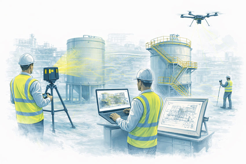
Engineering-grade LiDAR scanning infographic showing a FARO laser scanner capturing an industrial plant and converting site data into point clouds, scan-to-CAD models, and engineering-ready drawings to reduce rework and improve project outcomes.

In the world of industrial engineering and brownfield upgrades, there is a dangerous word: Assumption.

Whether you are upgrading a CHPP, modifying a conveyor system, or retrofitting a processing plant, your project is only as strong as the data itโ€™s built on. At Hamilton By Design, weโ€™ve seen how “near enough” measurements lead to costly rework, extended shutdowns, and safety risks.

The solution? Moving from manual estimation to Engineering-Led LiDAR Scanning.

The High Cost of Inaccurate Information

Traditional “manual” documentationโ€”using tape measures, spirit levels, and old 2D drawingsโ€”is prone to human error. In complex industrial environments, missing a single pipe interference or a slight structural lean by even 20mm can mean a prefabricated component wonโ€™t fit during a critical shutdown.

When site data is inaccurate:

  • Fabrication fails: Parts arrive on-site but don’t clear existing structures.
  • Costs skyrocket: Emergency “hot works” and on-site modifications blow out budgets.
  • Safety is compromised: Forced fits can create structural stress and unforeseen hazards.

Why Geometry is the Foundation of Engineering

Geometry isn’t just about shapes; it’s about the spatial relationship between every asset on your site. Accurate geometry is critical because:

  1. Clash Detection: It allows us to identify “soft” and “hard” clashes in a digital environment before a single bolt is turned.
  2. Structural Integrity: Precise angles and load-path documentation ensure that new modifications integrate safely with legacy steelwork.
  3. Efficiency: Understanding the exact volume, pitch, and clearance of a site allows for “First-Time-Fit” engineering.

LiDAR Scanning: The Simple Solution for Complex Reality

LiDAR (Light Detection and Ranging) removes the guesswork. A LiDAR scanner emits millions of laser pulses per second to create a Point Cloudโ€”a highly accurate 3D digital “twin” of your facility.

Why itโ€™s a game-changer:

  • Speed: Capture entire plant rooms or structural towers in minutes, not days.
  • Safety: We can scan hazardous or hard-to-reach areas from a safe distance, removing the need for scaffolding just to take a measurement.
  • Completeness: Unlike a manual survey that only measures what you think is important, LiDAR captures everything in its line of sight, providing context you might need later.

Beyond design, point cloud data serves as an indisputable “source of truth” in legal and insurance contexts. Because a scan is a timestamped, millimeter-accurate record of reality, it is increasingly used in:

  • Construction Disputes: Providing evidence of “as-built” conditions vs. “as-designed” plans to settle variations or defect claims.
  • Incident Investigation: In the event of a structural failure or site accident, a pre-existing or post-incident scan provides an objective 3D map for forensic analysis.
  • Asset Accountability: Scans serve as a permanent record of site conditions before a contractor begins work, protecting owners and contractors alike from liability.

The Hamilton By Design Difference

We don’t just provide “data.” We provide engineering-led reality capture. Because we are engineers and fabricators ourselves, we know what to look for when we scan. We don’t just give you a cloud of dots; we translate that data into usable CAD models and fabrication-ready drawings that respect Australian Standards (like AS 4324.1).

Stop guessing and start building with confidence. [Contact the Hamilton By Design team today] to discuss how our LiDAR scanning services can de-risk your next project.

Hamilton By Design logo displayed on a blue tilted rectangle with a grey gradient background
3D LiDAR scanning and 3D modelling service button โ€” laser scanner capturing a point cloud for engineering and CAD modelling
Mechanical engineering services
3D LiDAR scanning and 3D modelling service button โ€” laser scanner capturing a point cloud for engineering and CAD modelling
Mechanical engineering services
Finite Element Analysis (FEA) engineering simulation button
Mechanical engineering services

Mechanical Engineering | Structural Engineering


What Is the Difference Between a Terrestrial Scanner and a LiDAR Scanner?

Terrestrial, mobile SLAM and drone LiDAR scanners capturing an industrial plant with engineers reviewing point cloud data and drawings

Terrestrial vs LiDAR Scanners | Whatโ€™s the Difference?

Confusion around terrestrial scanning and LiDAR scanning is common โ€” and understandable.
The two terms are often used interchangeably, even though they describe different things.

This page explains the difference in plain language, shows where each approach fits, and helps you decide what level of accuracy and risk is appropriate for your project.


Short Answer (If Youโ€™re in a Hurry)

LiDAR describes the laser measurement technology.
Terrestrial describes how and where that LiDAR scanner is deployed.

Most terrestrial scanners use LiDAR, but not all LiDAR scanners are terrestrial.


Illustration comparing terrestrial LiDAR, mobile SLAM LiDAR and drone scanning on an industrial facility

What Is LiDAR?

LiDAR (Light Detection and Ranging) is a method of measuring distance using laser light.

How LiDAR works

  • A laser pulse is emitted
  • The pulse reflects off an object
  • The return time is measured
  • Distance is calculated and stored as a 3D point

Millions of these points form a point cloud that represents real-world geometry.

What LiDAR is good for

  • Accurate 3D measurement
  • Complex geometry
  • Low-light or enclosed environments
  • Engineering, construction, and industrial sites

LiDAR answers: How is distance measured?


What Is a Terrestrial Scanner?

A terrestrial scanner is a ground-based scanning system, usually mounted on a tripod or fixed position.

Key characteristics

  • Fixed scan position
  • Controlled setup and coverage
  • Known geometry and reference
  • High repeatability and validation

Typical environments

  • Processing plants and CHPPs
  • Structural steelwork
  • Conveyor systems
  • Brownfield tie-ins
  • As-built verification
  • Shutdown-critical fit-up work

Terrestrial answers: Where and how is the LiDAR deployed?


How the Two Terms Relate (This Is the Important Part)

A terrestrial scanner is a platform.
A LiDAR scanner is a technology.

Most modern terrestrial scanners are terrestrial LiDAR scanners.

Example: a tripod-mounted system such as the FARO Focus S-Series is:

  • LiDAR-based (laser measurement)
  • Terrestrial (ground-based, fixed setup)

Other Common LiDAR Scanner Types (And Why It Matters)

Scanner TypeHow Itโ€™s UsedTypical Outcome
Terrestrial LiDARTripod / fixedHighest control & accuracy
Mobile / SLAM LiDARHandheld / walk-throughFast capture, lower control
Vehicle-mounted LiDARCar / trolleyCorridor mapping
Aerial LiDARDrone / aircraftLarge areas, low detail

All are โ€œLiDARโ€, but not all are suitable for engineering design or fabrication.


Why This Distinction Matters for Projects

Many issues occur when:

  • A LiDAR scan is assumed to be engineering-grade
  • A mobile or SLAM scan is used beyond its intent
  • Accuracy, validation, or limitations are not clearly understood

This doesnโ€™t mean one method is wrong โ€” it means each has a purpose.

The key is aligning the scanner type with:

  • Required accuracy
  • Risk tolerance
  • Fit-up criticality
  • Intended use of the data

Our clients:


Simple Decision Guide (Client in Control)

If you need:

  • Fabrication or replacement parts โ†’ Terrestrial LiDAR
  • Shutdown-critical fit-up โ†’ Terrestrial LiDAR
  • Structural verification โ†’ Terrestrial LiDAR
  • Rapid site context only โ†’ Mobile / SLAM LiDAR
  • Large terrain or stockpiles โ†’ Aerial LiDAR

There is no โ€œone best scannerโ€ โ€” only the right scanner for the outcome you want.


Comparison at a Glance

RequirementTerrestrial LiDARMobile / SLAM LiDAR
Accuracy controlHighModerate
RepeatabilityHighLower
Engineering defensibilityStrongLimited
Fit-up confidenceSuitableNot recommended
Capture speedSlowerFaster
Best use caseDesign & fabricationVisualisation & context

A Note on Engineering Use

Where scanning data feeds into engineering design, documentation, or fabrication, higher-control methods are typically required to align with engineering practice and Australian Standards expectations.

That doesnโ€™t remove choice โ€” it simply means the assumptions and limitations must match the intended use.


How We Approach This (Without Locking You In)

Weโ€™re happy to:

  • Work with terrestrial, mobile, or supplied scan data
  • Validate data before design where required
  • Align scanning effort with your risk, budget, and outcome
  • Clearly document assumptions and limitations

You stay in control of the approach โ€” our role is to make sure the data supports the outcome you expect.


Hamilton By Design logo displayed on a blue tilted rectangle with a grey gradient background
3D LiDAR scanning and 3D modelling service button โ€” laser scanner capturing a point cloud for engineering and CAD modelling
Mechanical engineering services

Next Step

If youโ€™re unsure which scanning method suits your project:

Fill out the contact form and tell us:

  • What you want to build, replace, or verify
  • How the data will be used
  • Any constraints (budget, time, shutdown windows)

Weโ€™ll help you select a fit-for-purpose scanning approach, not just a scanner.


Name
Would you like us to arrange a phone consultation for you?
Address
Finite Element Analysis (FEA) engineering simulation button
Mechanical engineering services

Reverse Engineering 3D Scanning Melbourne

Engineer-Led Reverse Engineering from Scan to Fabrication โ€” Supporting Victoria & Remote Sites

At Hamilton By Design, we provide reverse engineering supported by engineering-grade 3D LiDAR scanning from our Melbourne engineering hub, helping maintenance teams, project engineers, and manufacturers replace, reproduce, or validate critical components when drawings are missing, obsolete, or no longer reflect site reality.

We specialise in like-for-like replacement and fit-for-purpose engineering, particularly for manufacturing facilities, bulk materials handling, brownfield infrastructure, and industrial plant, where shutdown windows are tight and first-time fit-up is critical.


Reverse Engineering Built on Real Site Data

Reverse engineering only works when it starts with what actually exists on site.

We use engineering-grade 3D LiDAR scanning to capture accurate geometry from worn, modified, or undocumented assets, then apply engineering judgement to develop engineered models and drawings suitable for fabrication and installation.

This removes reliance on:

  • Missing, outdated, or incomplete drawings
  • OEM data that no longer matches the asset
  • Manual measurements in live or congested environments
  • Assumptions that lead to rework during shutdowns

Managing Director Insight

โ€œReverse engineering isnโ€™t about copying geometry โ€” itโ€™s about understanding wear, interfaces, and how an asset needs to function once itโ€™s reinstalled. We use 3D scanning to capture reality, but itโ€™s engineering judgement that ensures replacement components fit and perform as intended.โ€

โ€” Anthony Hamilton, Managing Director, Hamilton By Design


What We Reverse Engineer

From our Melbourne base, we support Victorian and remote operations with reverse engineering of:

  • Conveyor components (pulleys, frames, guards, transfer assemblies)
  • Bulk materials handling equipment (chutes, hoppers, bins, screens)
  • Worn or damaged components requiring like-for-like replacement
  • Obsolete or unsupported OEM parts
  • Structural steel components and assemblies
  • Machined components, housings, and brackets

These assets are often located in brownfield, live, or space-constrained environments, where accurate capture and engineering ownership are essential.


Engineering-Grade Accuracy for Shutdown-Critical Fit-Up

Our reverse engineering approach is designed for shutdown-critical replacement work, not visual modelling.

We emphasise:

  • Engineering-grade LiDAR scanning suitable for fit-for-purpose replacement parts
  • Accuracy verified through engineering judgement, not point clouds alone
  • Manual verification of critical interfaces where required
  • Deliverables suitable for fabrication, installation, and inspection

Our work is engineering-grade and defensibleโ€”appropriate for mechanical and structural replacement in operating industrial environments.


Reverse Engineering as an Engineering Process

Reverse engineering is treated as a complete engineering process, with 3D scanning as one input.

Our typical workflow includes:

3D LiDAR scanning โ†’ point-cloud analysis โ†’ engineered 3D modelling โ†’ design intent definition โ†’ fabrication and installation drawings

Where required, this process may also include:

  • Mechanical or structural checks
  • Review of wear patterns and failure modes
  • Fit-for-purpose assessment against operational requirements

This ensures replacement components are engineered to work, not blindly replicated.


Engineering Ownership, Accountability & Risk Management

Reverse engineering carries real technical and commercial risk.

Our approach includes:

  • Engineering sign-off and accountability
  • Clear documentation of assumptions and limitations
  • Fit-for-purpose design intent aligned with operational reality
  • Engineering judgement consistent with Australian Standards
  • Lessons learned from real shutdowns, upgrades, and replacements

Deliverables are suitable for engineering review, audits, and compliance requirements.


Melbourne Engineering Hub Supporting Victoria & Remote Sites

We operate with Melbourne as our engineering base, supporting:

  • Manufacturing and industrial facilities across Victoria
  • Bulk materials handling and processing plants
  • Infrastructure and brownfield assets
  • Remote sites supported from Victoria
  • Fabricators and machine shops requiring accurate reverse-engineered data

This model provides local engineering accountability with the flexibility to support geographically dispersed assets.


Designed for Maintenance, Reliability & Project Engineers

This service is well suited to:

  • Maintenance and reliability engineers managing ageing assets
  • Project engineers planning shutdown replacements and upgrades
  • Manufacturers reproducing legacy or unsupported components
  • Asset owners dealing with undocumented modifications
  • Fabricators requiring accurate, fabrication-ready documentation

We work collaboratively with your teams, focusing on fit-first-time outcomes.


Hamilton By Design logo displayed on a blue tilted rectangle with a grey gradient background
3D LiDAR scanning and 3D modelling service button โ€” laser scanner capturing a point cloud for engineering and CAD modelling
Mechanical engineering services

Talk to Us About Reverse Engineering 3D Scanning in Melbourne

If youโ€™re dealing with missing drawings, obsolete components, or shutdown-critical replacements, weโ€™d welcome the opportunity to help.

Submit an enquiry via our contact form


Name
Would you like us to arrange a phone consultation for you?
Address


3D CAD Modelling Australia service banner for Hamilton By Design


CHPP Engineering title graphic featuring bold white text reading "CHPP Engineering" centred on a blue rounded rectangle background.
Pipework Drafting title graphic featuring bold white text reading "Pipework Drafting" centred on a blue rounded rectangle background.
3D LiDAR Scanning for Engineering Projects title graphic featuring bold white text on a blue rounded rectangle background.


Finite Element Analysis (FEA) engineering simulation button
Structural drafting services button
Mechanical drafting services button


Australian Drafting logo featuring bold white text reading "Australian Drafting" centred on a blue rounded rectangle background.
Engineering Governance title graphic featuring bold white text reading "Engineering Governance" centred on a blue rounded rectangle background.
Engineering-Grade LiDAR Scanning title graphic featuring bold white text on a blue rounded rectangle background.


Mechanical drafting services button
Structural drafting services button


Fabrication and product design services
3D CAD Modelling Australia service banner for Hamilton By Design
Mechanical, Structural & Pipework Drafting service banner by Hamilton By Design featuring white text on a blue background.


3D LiDAR scanning and 3D modelling service button โ€” laser scanner capturing a point cloud for engineering and CAD modelling
Mechanical engineering services