Why Engineering Planning Is Critical During Mining Shutdowns
Mining shutdowns are among the most complex operational events in industrial facilities. During these periods, large volumes of maintenance, upgrades, inspections, and equipment replacements must be completed within a tightly controlled timeframe.
Because production stops during shutdown work, every hour of delay can have a significant financial impact on operations.
This is where mining shutdown engineering plays a critical role. Proper engineering preparation ensures that upgrade work, equipment installation, and plant modifications can be executed safely and efficiently during the shutdown window.
Engineering support during shutdown projects often involves planning, documentation, scanning existing infrastructure, and preparing fabrication drawings before the shutdown begins.
At Hamilton By Design, engineering teams support mining shutdown work by providing accurate design data and technical documentation to ensure shutdown activities proceed as planned.
The Challenges of Mining Shutdown Projects
Mining shutdown projects involve coordinating multiple teams working across different areas of the plant simultaneously.
Common challenges include:
• limited shutdown timeframes
• complex plant infrastructure
• multiple contractors working concurrently
• incomplete or outdated plant drawings
• installation clashes between new and existing equipment
Without proper engineering preparation, shutdown work can quickly encounter unexpected obstacles that extend downtime and increase costs.
Engineering support helps minimise these risks by ensuring the plant layout, equipment geometry, and installation requirements are clearly understood before work begins.
Engineering Services That Support Shutdown Planning
Mining shutdown engineering typically involves several technical activities carried out prior to the shutdown window.
Plant Layout Verification
Before any upgrade work begins, engineers often need to verify the existing layout of equipment, pipework, and structures.
Many mining facilities have evolved over decades of maintenance work, meaning the actual plant configuration may differ from the original drawings.
Capturing accurate existing conditions ensures that shutdown installation work can proceed without unexpected clashes.
Learn more about capturing existing conditions here:
3D Laser Scanning of Existing Infrastructure
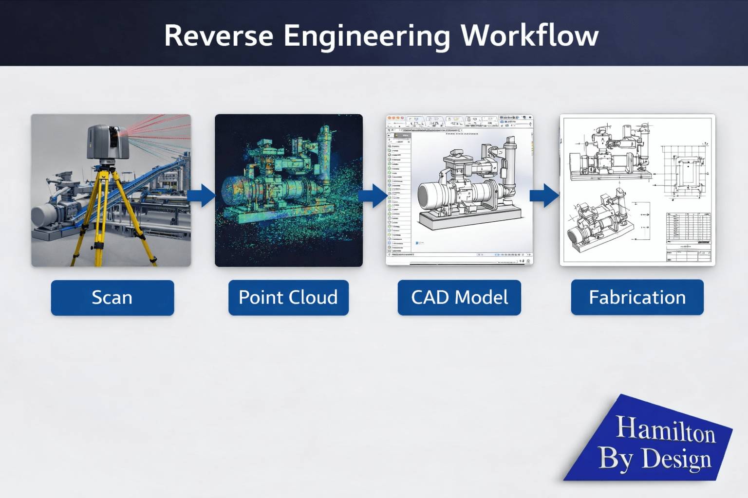
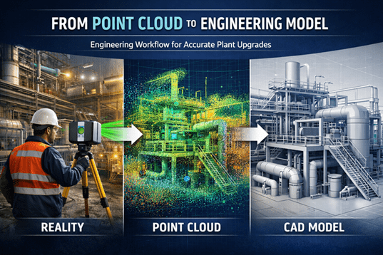
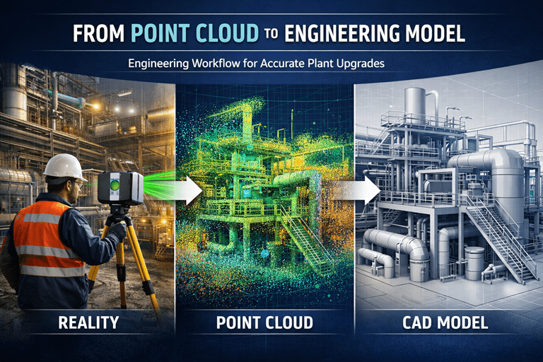
3D laser scanning is frequently used to document plant geometry before shutdown work begins.
Scanning allows engineers to capture millions of measurement points from existing infrastructure and generate accurate point cloud models of the plant environment.
These models help engineers design equipment modifications and plan installation sequences with greater confidence.
More information about engineering-grade scanning services:
Engineering Modelling and Design
Once site data has been captured, engineers can develop digital models used to design plant modifications or equipment upgrades.
These models help engineering teams:
• design new components that fit existing plant infrastructure
• identify potential clashes before installation
• improve coordination between mechanical and structural systems
• support fabrication of new equipment
The workflow of converting scan data into engineering models is explained here:
Equipment Upgrades During Shutdown Work
Shutdown windows are often used to install new equipment or upgrade existing plant systems.
Typical shutdown upgrade projects may include:
• conveyor system upgrades
• pump replacements
• pipework modifications
• structural upgrades
• installation of new process equipment
Engineering support ensures these modifications are designed to integrate with the existing plant layout while meeting operational and safety requirements.
Benefits of Engineering Preparation Before Shutdown
Engineering preparation carried out before the shutdown window helps mining operations complete work more efficiently.
Key benefits include:
• reduced installation risk
• improved equipment fitment
• shorter shutdown durations
• improved coordination between contractors
• reduced rework during installation
By preparing engineering documentation in advance, shutdown teams can focus on executing work safely and efficiently.
Supporting Safe and Efficient Shutdown Operations
Mining shutdown engineering is not only about improving efficiency — it also supports safe operations.
Accurate engineering documentation helps ensure that:
• installation procedures are clearly defined
• equipment interfaces are properly designed
• access and maintenance requirements are considered
• potential safety hazards are identified early
For complex mining plants, this level of preparation significantly improves shutdown execution.

Conclusion
Mining shutdowns are critical operational events where significant maintenance and upgrade work must be completed within a limited timeframe.
Engineering preparation plays an essential role in ensuring shutdown projects are executed safely and efficiently.
Through activities such as plant scanning, engineering modelling, and design preparation, mining shutdown engineering helps reduce operational risk and improve the success of shutdown projects.
Hamilton By Design provides engineering support services to assist mining operations with shutdown planning, plant upgrades, and infrastructure modifications.


Our clients