The Digital Source of Truth: Using LiDAR Scanning to Resolve Residential Property Disputes

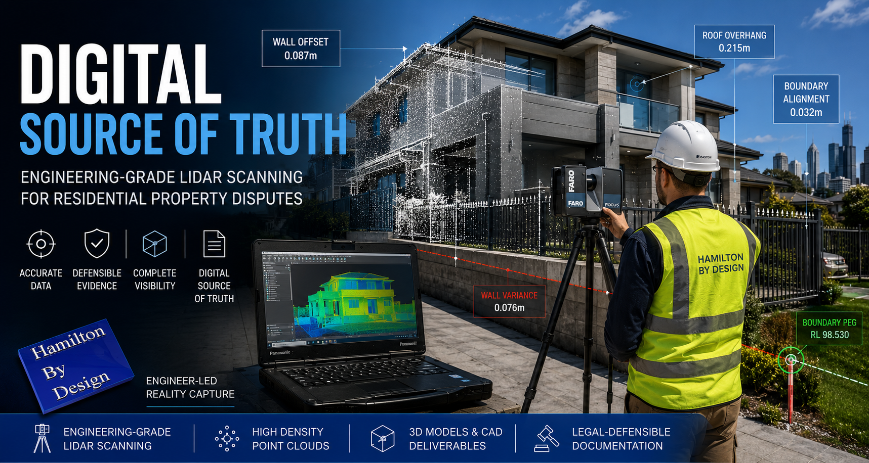
Engineer operating a FARO LiDAR scanner outside a modern Australian home while capturing point cloud data for residential property dispute analysis.

In residential property, a few centimeters can be the difference between a successful renovation and a decade-long legal battle. Whether it’s a dispute over a boundary fence, a claim regarding a construction defect, or an insurance argument over structural movement, the “he-said, she-said” of manual measurements is no longer enough.

At Hamilton By Design, we provide homeowners and legal teams with a “Digital Source of Truth” through high-precision LiDAR (Light Detection and Ranging) scanning.

Why “Near Enough” Isn’t Enough in Residential Law

Traditional property documentation often relies on old paper titles or handheld tape measurements. These methods are prone to human error and fail to capture the complex, three-dimensional reality of a home.

In a legal setting, ambiguity is the enemy. If you are heading to mediation or court, you need data that is objective, repeatable, and millimeter-accurate. LiDAR offers a simple, non-invasive solution for documenting every corner of a property’s geometry.

1. Encroachment & Boundary Disputes

The most common residential dispute often involves a fence, retaining wall, or overhanging structure. A LiDAR scan creates a “Point Cloud”—a 3D map of millions of data points—that can be overlaid with official cadastral surveys. This proves exactly where a structure sits in relation to the legal boundary, leaving no room for argument.

2. Construction Defect & Variation Claims

If a builder has installed a wall that isn’t plumb, or a slab that is out of level, manual checks can be disputed. A LiDAR scan captures the entire surface geometry of the building. We can produce “heat maps” that visually demonstrate deviations from the design plans, providing undeniable evidence of whether or not a project meets Australian Standards.

3. Dilapidation Surveys (The “Before & After”)

Before a neighbor begins a major excavation or a council starts roadworks, a LiDAR scan acts as a “digital time capsule.” It documents the exact current state of your home—including existing cracks or structural leans. If damage occurs during the nearby construction, you have a 3D record to prove the change, making insurance claims significantly smoother.

4. Forensic Investigation & Evidence

In more serious cases, such as structural failures or fire damage, LiDAR allows for a “virtual walkthrough” of the scene. Judges and juries can navigate a digital twin of the property, understanding spatial relationships and damage patterns that 2D photos simply cannot convey.

The Value of Geometry

Geometry is the mathematical language of your property. By capturing the precise angles, elevations, and volumes of a home, we help owners:

  • Identify structural movement over time.
  • Calculate exact volumes for material disputes.
  • Verify solar access or view loss in planning disputes.

Bringing Certainty to Your Case

A point cloud is more than just a scan; it is a permanent, digital record that can be revisited years later if new issues arise. At Hamilton By Design, we bridge the gap between complex laser data and practical legal evidence.

Protect your most valuable asset with data that stands up in court. —

Would you like me to create a “Checklist for Homeowners” section to add to this post, detailing when they should consider a scan?


Hamilton By Design logo displayed on a blue tilted rectangle with a grey gradient background
3D LiDAR scanning and 3D modelling service button — laser scanner capturing a point cloud for engineering and CAD modelling
Mechanical engineering services
3D LiDAR scanning and 3D modelling service button — laser scanner capturing a point cloud for engineering and CAD modelling
Mechanical engineering services
Finite Element Analysis (FEA) engineering simulation button
Mechanical engineering services

Mechanical Engineering | Structural Engineering


Beyond Assumptions: Why Accurate Geometry and LiDAR Scanning are the Gold Standard for Modern Projects

Engineering-grade LiDAR scanning infographic showing a FARO laser scanner capturing an industrial plant and converting site data into point clouds, scan-to-CAD models, and engineering-ready drawings to reduce rework and improve project outcomes.

In the world of industrial engineering and brownfield upgrades, there is a dangerous word: Assumption.

Whether you are upgrading a CHPP, modifying a conveyor system, or retrofitting a processing plant, your project is only as strong as the data it’s built on. At Hamilton By Design, we’ve seen how “near enough” measurements lead to costly rework, extended shutdowns, and safety risks.

The solution? Moving from manual estimation to Engineering-Led LiDAR Scanning.

The High Cost of Inaccurate Information

Traditional “manual” documentation—using tape measures, spirit levels, and old 2D drawings—is prone to human error. In complex industrial environments, missing a single pipe interference or a slight structural lean by even 20mm can mean a prefabricated component won’t fit during a critical shutdown.

When site data is inaccurate:

  • Fabrication fails: Parts arrive on-site but don’t clear existing structures.
  • Costs skyrocket: Emergency “hot works” and on-site modifications blow out budgets.
  • Safety is compromised: Forced fits can create structural stress and unforeseen hazards.

Why Geometry is the Foundation of Engineering

Geometry isn’t just about shapes; it’s about the spatial relationship between every asset on your site. Accurate geometry is critical because:

  1. Clash Detection: It allows us to identify “soft” and “hard” clashes in a digital environment before a single bolt is turned.
  2. Structural Integrity: Precise angles and load-path documentation ensure that new modifications integrate safely with legacy steelwork.
  3. Efficiency: Understanding the exact volume, pitch, and clearance of a site allows for “First-Time-Fit” engineering.

LiDAR Scanning: The Simple Solution for Complex Reality

LiDAR (Light Detection and Ranging) removes the guesswork. A LiDAR scanner emits millions of laser pulses per second to create a Point Cloud—a highly accurate 3D digital “twin” of your facility.

Why it’s a game-changer:

  • Speed: Capture entire plant rooms or structural towers in minutes, not days.
  • Safety: We can scan hazardous or hard-to-reach areas from a safe distance, removing the need for scaffolding just to take a measurement.
  • Completeness: Unlike a manual survey that only measures what you think is important, LiDAR captures everything in its line of sight, providing context you might need later.

Beyond design, point cloud data serves as an indisputable “source of truth” in legal and insurance contexts. Because a scan is a timestamped, millimeter-accurate record of reality, it is increasingly used in:

  • Construction Disputes: Providing evidence of “as-built” conditions vs. “as-designed” plans to settle variations or defect claims.
  • Incident Investigation: In the event of a structural failure or site accident, a pre-existing or post-incident scan provides an objective 3D map for forensic analysis.
  • Asset Accountability: Scans serve as a permanent record of site conditions before a contractor begins work, protecting owners and contractors alike from liability.

The Hamilton By Design Difference

We don’t just provide “data.” We provide engineering-led reality capture. Because we are engineers and fabricators ourselves, we know what to look for when we scan. We don’t just give you a cloud of dots; we translate that data into usable CAD models and fabrication-ready drawings that respect Australian Standards (like AS 4324.1).

Stop guessing and start building with confidence. [Contact the Hamilton By Design team today] to discuss how our LiDAR scanning services can de-risk your next project.

Hamilton By Design logo displayed on a blue tilted rectangle with a grey gradient background
3D LiDAR scanning and 3D modelling service button — laser scanner capturing a point cloud for engineering and CAD modelling
Mechanical engineering services
3D LiDAR scanning and 3D modelling service button — laser scanner capturing a point cloud for engineering and CAD modelling
Mechanical engineering services
Finite Element Analysis (FEA) engineering simulation button
Mechanical engineering services

Mechanical Engineering | Structural Engineering


Establish a Baseline for Wall Movement in Your Property

Wall Crack Monitoring & Structural Movement Baseline Scans | NSW

Know When Cracks Are Cosmetic — and When They’re Not

Cracks in walls are common, but not all cracks are harmless. The real risk isn’t just that a crack exists — it’s how fast it’s changing. Without a baseline, there’s no reliable way to tell whether your property is stable or slowly moving toward serious structural damage.

That’s where our Property Wall Movement Baseline Scan comes in.


What Is a Baseline Scan?

A baseline scan is a high‑accuracy digital survey of your property taken at the moment cracking is first observed. Using precision scanning technology, we capture:

  • Wall alignment and deflection
  • Crack location, length, and width
  • Floor and ceiling reference planes
  • Structural reference points across the building

This scan becomes your time‑zero reference point — a measurable snapshot of your building’s condition today.


Why a Baseline Matters

Without a baseline:

  • Cracks are judged visually (subjective and unreliable)
  • Engineers lack historical movement data
  • Insurance claims become harder to substantiate
  • Small issues can quietly become major repairs

With a baseline:

  • Movement can be quantified in millimetres
  • Crack growth rates can be tracked over time
  • Engineers can make confident, data‑driven decisions
  • You gain early warning before damage becomes critical

How the Process Works

1. Initial Scan

We perform a non‑invasive scan of affected areas and key structural zones to establish your baseline condition.

2. Data Archiving

All scan data is securely stored and referenced to fixed control points within your property.

3. Follow‑Up Scans

Repeat scans (3, 6, or 12 months later) are compared against the baseline to calculate:

  • Crack propagation rate
  • Wall movement direction
  • Structural settlement or heave

4. Clear Reporting

You receive a clear, easy‑to‑understand report showing:

  • Measured movement (if any)
  • Rate of change over time
  • Professional recommendations

Ideal For

  • Homeowners noticing new or worsening cracks
  • Properties affected by reactive soils or subsidence
  • Buildings near excavation or construction activity
  • Insurance documentation and dispute resolution
  • Engineers requiring long‑term movement data

Early Data Saves Money

Monitoring movement early often means minor intervention instead of major reconstruction. A baseline scan gives you certainty, evidence, and peace of mind.

If nothing is moving — you’ll know.
If something is — you’ll know before it’s too late.


Hamilton By Design logo displayed on a blue tilted rectangle with a grey gradient background
3D LiDAR scanning and 3D modelling service button — laser scanner capturing a point cloud for engineering and CAD modelling
Mechanical engineering services

Book a Baseline Scan

If you’ve noticed cracking, now is the right time to act.

Contact us today to establish your property’s movement baseline and protect its long‑term structural integrity.


Precision data. Clear answers. Smarter decisions.

Name
Would you like us to arrange a phone consultation for you?
Address
3D LiDAR scanning and 3D modelling service button — laser scanner capturing a point cloud for engineering and CAD modelling
Mechanical engineering services
Finite Element Analysis (FEA) engineering simulation button
Mechanical engineering services

Mechanical Engineering | Structural Engineering


Engineering-Led 3D Scanning for Brownfield Industrial Upgrades

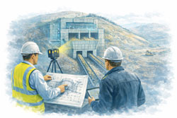
Mechanical engineer and client reviewing a ROM hopper with two discharge conveyors using LiDAR scanning at a mining bulk material handling facility

Engineering-Led 3D Scanning for Brownfield Industrial Upgrades

Safer Shutdowns, Smarter Design, and More Done With Fewer Resources

Brownfield industrial upgrades are some of the highest-risk engineering activities in mining and heavy industry. Existing assets, live plant interfaces, limited access, and tight shutdown windows leave little room for error.

At Hamilton By Design, we deliver engineering-led 3D LiDAR scanning to support brownfield upgrades—providing accurate site data that enables safer design, efficient shutdown execution, and reliable outcomes when upgrading critical assets such as hoppers, chutes, pump boxes, conveyor transfers, and vertical shaft units.


Why Brownfield Upgrades Fail Without Accurate Site Data

Many brownfield failures trace back to the same root cause:

Design decisions made on assumptions, not reality.

Common issues include:

  • Outdated or incomplete drawings
  • Hidden interferences and undocumented modifications
  • Restricted access for survey and measurement
  • Time pressure during shutdowns

Engineering-led reality capture removes uncertainty before fabrication and installation begin.


Safety Starts Before the Shutdown

Safety in brownfield environments is largely determined during the design phase, not on site.

3D LiDAR scanning allows engineers to:

  • Design modifications without repeated site access
  • Reduce manual measurements in live plant areas
  • Identify clashes and pinch points early
  • Improve access, guarding, and maintainability outcomes

By reducing exposure hours and unplanned rework, scanning directly supports safer shutdown execution.


Typical Assets Upgraded in Brownfield Environments

Hamilton By Design supports upgrades to a wide range of industrial assets, including:

Hoppers & Chutes

  • ROM hoppers
  • Transfer chutes
  • Surge bins
  • Wear-prone interfaces

Conveyors & Transfer Stations

  • Conveyor head and tail stations
  • Transfer points
  • Discharge transitions
  • Supporting steelwork

Pump Boxes & Process Interfaces

  • Pump boxes and sumps
  • Pipework interfaces
  • Structural supports
  • Access platforms

Vertical Shaft & Drop Structures

  • Vertical shaft hoppers
  • Ore passes
  • Gravity-fed transfer systems

These assets are often deeply integrated into existing plant, making accurate as-built data critical.


Engineering-Led Scan-to-CAD for Upgrade Design

Our scan-to-CAD workflows are built around engineering outcomes, not just visual models.

This includes:

  • High-accuracy LiDAR capture of existing conditions
  • Engineering-intent CAD modelling
  • Design for fabrication and installation
  • Clash reduction across mechanical and structural scopes

The result is buildable design that aligns with real-world constraints.


Reliable Support for Shutdown-Driven Projects

Shutdowns demand precision. There is no time for re-measurements or redesign on site.

Engineering-led 3D scanning supports shutdown success by:

  • Allowing design to be completed well before shutdown
  • Supporting pre-fabrication of steelwork and chutes
  • Reducing RFIs and site queries
  • Increasing the amount of work completed per shutdown

When time and labour are limited, better information delivers better outcomes.


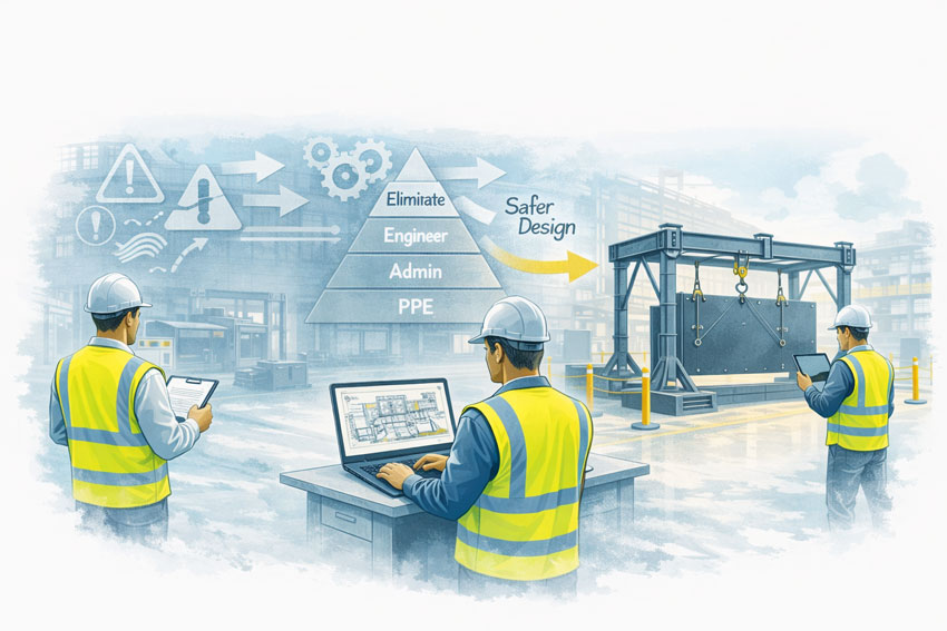
Mining engineers applying design-for-safety principles to improve material handling systems in an industrial workshop

Getting More Done With Fewer Resources

In today’s industrial environment, engineering teams are under pressure to:

  • Do more with fewer people
  • Reduce shutdown durations
  • Control capital and maintenance costs

Accurate digital site data allows teams to:

  • Minimise engineering rework
  • Reduce site-based labour
  • Improve coordination between disciplines
  • Make confident decisions faster

Reality capture becomes a force multiplier, not just a documentation tool.


Australian Engineering Quality You Can Rely On

Hamilton By Design’s approach reflects Australian engineering standards and site experience.

We don’t just scan — we:

  • Understand how plant is built and maintained
  • Design with fabrication and installation in mind
  • Take responsibility for engineering outcomes

This sets our work apart from low-cost capture services that leave risk unresolved.


Hamilton By Design logo displayed on a blue tilted rectangle with a grey gradient background


3D LiDAR scanning and 3D modelling service button — laser scanner capturing a point cloud for engineering and CAD modelling
Mechanical engineering services

Speak With an Engineer

If you’re planning a brownfield upgrade involving:

  • Hoppers or chutes
  • Conveyor transfers
  • Pump boxes or sumps
  • Vertical shaft or drop structures
  • Shutdown-critical works

Hamilton By Design provides engineering-led 3D LiDAR scanning to support safer, more reliable brownfield upgrades.

Name
Would you like us to arrange a phone consultation for you?
Address

Our clients:


Finite Element Analysis (FEA) engineering simulation button
Mechanical engineering services

Mechanical Engineering | Structural Engineering


3D LiDAR Scanning for Industrial Facilities in Western Sydney

Mechanical engineer and client reviewing construction drawings beside a LiDAR scanner at a Western Sydney construction site with Sydney Olympic Park and Parramatta skyline in the background

3D LiDAR Scanning for Industrial Facilities in Western Sydney | Engineering-Led Reality Capture

Engineering-Led Reality Capture for Safer, More Accurate Project Outcomes

Western Sydney is one of Australia’s most active industrial and construction corridors. From large-scale warehousing and manufacturing facilities to logistics hubs, utilities, and infrastructure assets, the region demands accurate site data, safe project delivery, and engineering accountability.

At Hamilton By Design, we provide engineering-led 3D LiDAR scanning services across Western Sydney to support industrial facilities through design, modification, shutdown planning, and asset upgrades—bridging the gap between site reality and build-ready engineering models.


Engineering-led 3D LiDAR scanning at a Western Sydney construction site with a steel-frame building, client consultation, and Parramatta CBD visible in the background

Why Western Sydney Industrial Projects Demand Engineering-Grade Scanning

Industrial sites in Western Sydney often present complex challenges:

  • Live operations with limited access windows
  • Legacy assets with incomplete or outdated drawings
  • Tight safety requirements and compliance obligations
  • Cost pressure from construction programs and shutdown schedules

In these environments, assumptions are expensive. Engineering-grade reality capture removes uncertainty before it reaches site.


Hot Topics Driving Engineering & Construction Decisions

1. Safety Starts With Accurate Information

Safety in industrial facilities begins long before construction or installation.

3D LiDAR scanning allows engineers to:

  • Identify clashes before fabrication
  • Design access platforms, walkways, and guards accurately
  • Reduce site rework, hot works, and manual re-measurement
  • Support safer shutdown planning and installation sequencing

Accurate digital site data reduces exposure hours and lowers risk across the project lifecycle.


2. Australian Engineering Quality vs Low-Cost Shortcuts

Cheaper scanning or modelling options often focus on speed over accuracy—leaving engineers to resolve issues later on site.

Hamilton By Design’s approach is different:

  • Engineer-led scanning, not technician-only capture
  • Models developed with mechanical, structural, and fabrication intent
  • Practical site experience informing what actually matters in design

This Australian engineering know-how delivers defensible, buildable outcomes, not just visually impressive models.


3. Scan-to-CAD: Turning Reality Into Buildable Design

Industrial clients don’t just need point clouds — they need usable engineering deliverables.

Our scan-to-CAD workflows support:

  • Mechanical and structural design
  • Conveyor, plant, and equipment modifications
  • Brownfield upgrades and extensions
  • Fabrication-ready drawings

By aligning reality capture directly with CAD and engineering workflows, we reduce rework, RFIs, and late-stage changes.


4. Supporting Digital Twins for Industrial Assets

3D LiDAR scanning is increasingly used as the foundation for digital twins in industrial environments.

For Western Sydney facilities, this supports:

  • Asset documentation and lifecycle management
  • Future expansion planning
  • Maintenance access reviews
  • Engineering audits and compliance records

Reality capture ensures digital twins are based on what exists, not what drawings suggest.


Mining engineers applying design-for-safety principles to improve material handling systems in an industrial workshop

Typical Western Sydney Industrial Applications

Hamilton By Design supports a wide range of industrial facilities across Western Sydney, including:

  • Warehouses and logistics centres
  • Manufacturing plants
  • Processing and handling facilities
  • Utilities and infrastructure assets
  • Brownfield industrial upgrades

Our services are suited to both small targeted scans and large-scale facility capture, depending on project needs.


How This Supports Sydney-Wide 3D Scanning Services

Western Sydney projects form a key part of our broader Sydney-based 3D scanning services, supporting engineering and construction projects across metropolitan and regional NSW.

By combining engineering oversight, LiDAR accuracy, and scan-to-CAD expertise, we help clients move from uncertainty to confident decision-making.

👉 Learn more about our engineering-led 3D scanning services across Sydney through our dedicated Sydney page.

(Use a partial-match internal link here — not exact-match anchor text.)


Hamilton By Design logo displayed on a blue tilted rectangle with a grey gradient background
3D LiDAR scanning and 3D modelling service button — laser scanner capturing a point cloud for engineering and CAD modelling
Mechanical engineering services

Speak With an Engineer

If you’re planning:

  • An industrial upgrade or expansion
  • A brownfield modification
  • A shutdown or complex installation
  • A scan-to-CAD workflow for engineering design

Hamilton By Design provides engineering-led 3D LiDAR scanning that supports safer, more predictable outcomes across Western Sydney.


Name
Would you like us to arrange a phone consultation for you?
Address

Our clients:


Mechanical Engineering | Structural Engineering


Blue banner graphic displaying the text "Point Cloud to CAD - Australia" in large white lettering, representing point cloud processing, scan-to-CAD conversion and digital engineering services across Australia.
Blue banner graphic displaying the text "Scan to CAD Sydney" in large white lettering, representing engineering-led point cloud to CAD conversion, LiDAR scanning and digital engineering services in Sydney.
Blue banner graphic displaying the text "Reality Capture Sydney - CBD" in large white lettering, representing engineering-led reality capture, LiDAR scanning and digital engineering services within Sydney CBD commercial buildings and infrastructure.

3D CAD Modelling Australia service banner for Hamilton By Design


CHPP Engineering title graphic featuring bold white text reading "CHPP Engineering" centred on a blue rounded rectangle background.
Pipework Drafting title graphic featuring bold white text reading "Pipework Drafting" centred on a blue rounded rectangle background.
3D LiDAR Scanning for Engineering Projects title graphic featuring bold white text on a blue rounded rectangle background.


Finite Element Analysis (FEA) engineering simulation button
Structural drafting services button
Mechanical drafting services button


Australian Drafting logo featuring bold white text reading "Australian Drafting" centred on a blue rounded rectangle background.
Engineering Governance title graphic featuring bold white text reading "Engineering Governance" centred on a blue rounded rectangle background.
Engineering-Grade LiDAR Scanning title graphic featuring bold white text on a blue rounded rectangle background.


Mechanical drafting services button
Structural drafting services button


Fabrication and product design services
3D CAD Modelling Australia service banner for Hamilton By Design
Mechanical, Structural & Pipework Drafting service banner by Hamilton By Design featuring white text on a blue background.


3D LiDAR scanning and 3D modelling service button — laser scanner capturing a point cloud for engineering and CAD modelling
Mechanical engineering services

Bulk Material Handling in Mining: Engineering the Movement of Raw Materials from ROM to Plant

Mechanical engineer and client reviewing a ROM hopper with two discharge conveyors using LiDAR scanning at a mining bulk material handling facility

Bulk Material Handling in Mining | ROM, Conveyors & Transfer Engineering

Bulk material handling is at the core of almost every mining operation. From the moment raw material is extracted at the Run-of-Mine (ROM) pad through to crushing, screening, processing, and stockpiling, the safe and efficient movement of material is critical to productivity, asset reliability, and worker safety.

At Hamilton By Design, we support mining and heavy-industry clients with engineering-led mechanical design, verification, and documentation for bulk material handling systems—focusing on conveyors, transfer points, chutes, ROM bins, hoppers, and associated steelwork.


Engineering-led ROM hopper and dual conveyor discharge system being verified with LiDAR scanning in an open-cut mining operation

What Is Bulk Material Handling in Mining?

Bulk material handling refers to the mechanical systems used to move large volumes of raw or processed material, including:

  • Run-of-Mine (ROM) ore
  • Crushed rock and coal
  • Overburden and rejects
  • Processed product and fines

These systems typically include:

  • Apron feeders and ROM bins
  • Primary, secondary, and tertiary crushers
  • Conveyor belts and transfer stations
  • Chutes, hoppers, and bins
  • Stackers, reclaimers, and stockpiles

Each interface between machines is a design-critical point where poor geometry, misalignment, or incorrect loading assumptions can lead to blockages, excessive wear, spillage, downtime, and safety risks.


Engineering Challenges in Bulk Material Handling

Bulk handling systems operate under harsh conditions and face unique engineering challenges:

1. Variable Material Properties

  • Changes in moisture content, particle size, and bulk density
  • Segregation and fines generation
  • Adhesion and carryback issues

2. Transfer Point Design

  • Impact loading and wear at chute inlets
  • Flow control and trajectory management
  • Dust, spillage, and maintenance access

3. Structural and Mechanical Loads

  • Dynamic loads from material flow
  • Belt tensions and starting/stopping forces
  • Fatigue in steelwork and supports

4. Brownfield Constraints

  • Existing plant geometry and limited space
  • Legacy drawings that don’t reflect as-built conditions
  • Shutdown-driven installation windows

These challenges reinforce why engineering-led design, supported by accurate site data, is essential.


From ROM to Processing: A System-Based Engineering Approach

Hamilton By Design approaches bulk material handling as a complete system, not isolated components.

Our typical workflow includes:

  1. Engineering-led site verification
    Using high-accuracy 3D LiDAR scanning to capture existing conditions at ROM pads, conveyors, and plant interfaces.
  2. Mechanical and structural design
    Developing fit-for-purpose conveyor layouts, transfer chutes, supports, and access platforms using SolidWorks-based workflows.
  3. Load definition and verification
    Applying realistic material loads and operational scenarios to reduce over-design and manage fatigue risk.
  4. Fabrication-ready documentation
    Producing drawings and models that support fit-first-time fabrication and installation during shutdowns.

This integrated approach reduces rework, delays, and operational risk.


Conveyor Transfer Points: Where Most Problems Begin

Transfer points are the highest-risk locations in bulk material handling systems.

Common issues include:

  • Poor material trajectory control
  • Excessive impact and liner wear
  • Dust escape and spillage
  • Restricted inspection and maintenance access

Engineering-led transfer design considers:

  • Material flow paths and impact angles
  • Chute geometry and liner selection
  • Maintenance clearances and access
  • Compliance with guarding and safety standards

Well-designed transfer points improve availability, reduce maintenance costs, and enhance safety outcomes.


Why Engineering Matters More Than Ever in Mining Handling Systems

As mining operations push for higher throughput and tighter shutdown schedules, the tolerance for design error is shrinking.

Engineering-driven bulk material handling delivers:

  • Predictable material flow
  • Reduced downtime and blockages
  • Improved safety and maintainability
  • Defensible design records for audits and compliance

This is especially important in brownfield mining environments, where assumptions based on outdated drawings can introduce significant risk.


Mining engineers applying design-for-safety principles to improve material handling systems in an industrial workshop

Supporting Mining Operations Across Australia

Hamilton By Design supports bulk material handling projects across:

  • Coal handling and preparation plants (CHPPs)
  • Hard-rock crushing and screening facilities
  • Mineral processing plants
  • Ports, stockyards, and materials terminals

Our experience spans ROM handling, conveyors, transfer chutes, and plant upgrades, backed by practical site experience and engineering accountability.


Hamilton By Design logo displayed on a blue tilted rectangle with a grey gradient background
3D LiDAR scanning and 3D modelling service button — laser scanner capturing a point cloud for engineering and CAD modelling
Mechanical engineering services

Speak With an Engineer

If you are planning:

  • A ROM handling upgrade
  • Conveyor or transfer chute modifications
  • Crushing plant changes
  • Shutdown-driven bulk handling works

👉 Contact Hamilton By Design to discuss an engineering-led approach that reduces risk and improves outcomes.


Name
Would you like us to arrange a phone consultation for you?
Address

Our clients:


3D CAD Modelling Australia service banner for Hamilton By Design
Australian Drafting logo featuring bold white text reading "Australian Drafting" centred on a blue rounded rectangle background.
Engineering Governance title graphic featuring bold white text reading "Engineering Governance" centred on a blue rounded rectangle background.
Mechanical, Structural & Pipework Drafting service banner by Hamilton By Design featuring white text on a blue background.
Mechanical engineering services
Blue rounded button with the text “SolidWorks Design” in white.
Finite Element Analysis (FEA) engineering simulation button
3D LiDAR Scanning Darwin for engineering surveys, laser scanning, reality capture and point cloud modelling services
3D LiDAR Scanning Australia engineering services for laser scanning, reality capture, scan-to-CAD, Scan-to-BIM and as-built documentation across Australia
3D LiDAR scanning services on the Central Coast providing engineering-grade laser scanning, point cloud capture, scan-to-CAD modelling and industrial reality capture for infrastructure and industrial projects.
3D LiDAR Scanning Perth for engineering surveys, laser scanning, reality capture and point cloud modelling services
3D LiDAR Scanning Sydney for engineering surveys, laser scanning, reality capture and point cloud modelling services
3D LiDAR Scanning Brisbane for engineering surveys, laser scanning, reality capture and point cloud modelling services
3D LiDAR Scanning Canberra for engineering surveys, laser scanning, reality capture and point cloud modelling services
3D LiDAR Scanning Newcastle for engineering surveys, laser scanning, reality capture and point cloud modelling services
3D LiDAR Scanning Adelaide for engineering surveys, laser scanning, reality capture and point cloud modelling services