

How the Right Information, 3D Scanning and Engineering Tools Drive Project Success
Your Success Is Our Success
Every project manager starts with the same objective:
Deliver a successful project safely, on time and within budget.
Whether the project involves a mining operation, manufacturing facility, port infrastructure, processing plant, water treatment facility, conveyor system, structural upgrade or equipment installation, success ultimately depends on the quality of the decisions made throughout the project lifecycle.
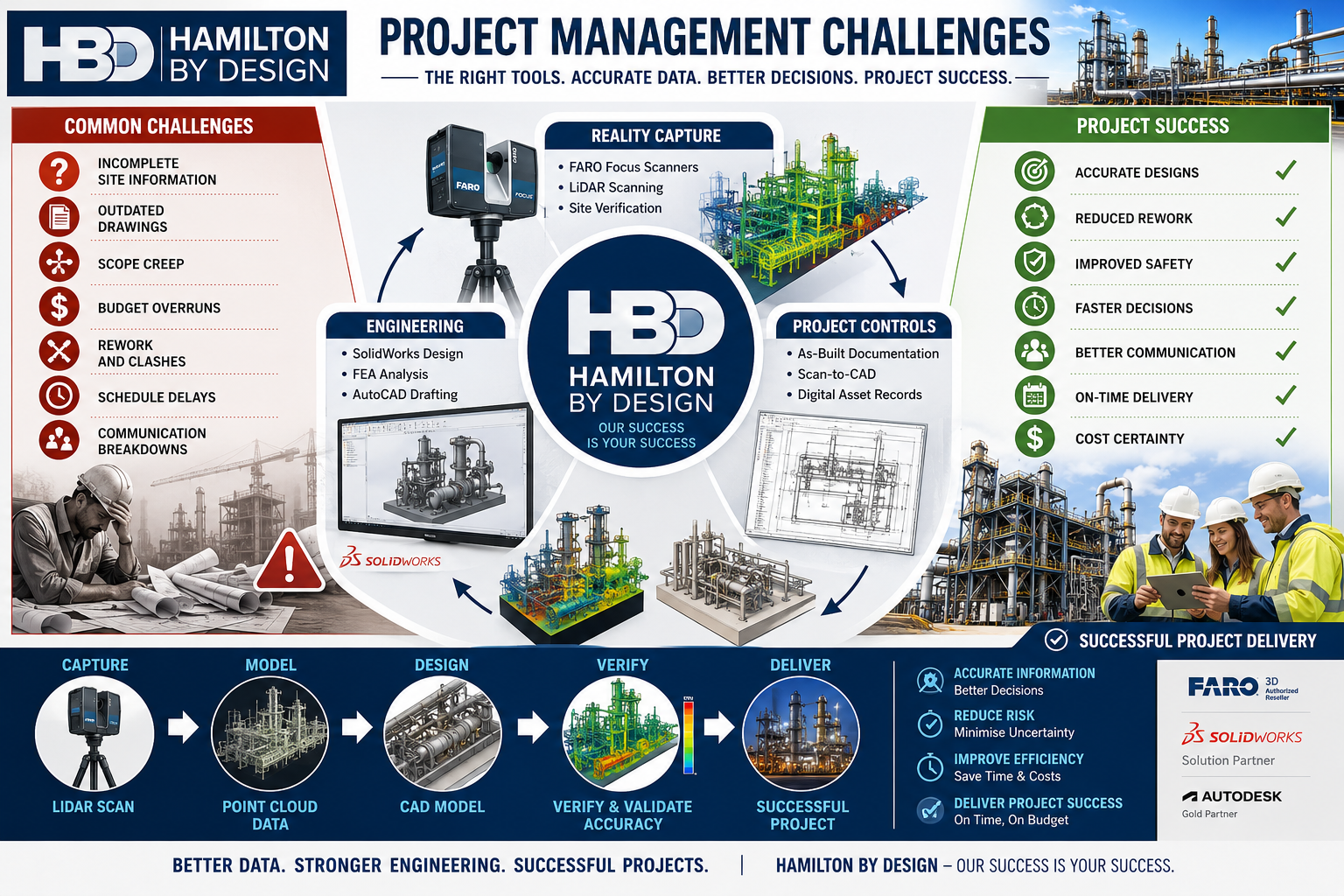
Unfortunately, project managers often face significant challenges:
- Inaccurate drawings
- Unknown site conditions
- Scope creep
- Communication issues
- Budget pressures
- Schedule constraints
- Construction clashes
- Fabrication errors
- Asset documentation gaps
These challenges rarely occur because people are not trying hard enough.
Most occur because project teams are making decisions with incomplete or inaccurate information.
At Hamilton By Design, we believe project success starts with good information.
That is why we have invested in engineering-grade 3D scanning technologies, digital engineering workflows, CAD platforms, simulation tools and practical engineering expertise to help our clients reduce risk and improve project outcomes.
Your success is our success.
Learn more:
- https://www.hamiltonbydesign.com.au/
- https://hamiltonbydesign.blogspot.com/
- https://pipeworkdetailing.blogspot.com/
Why Projects Struggle
Project managers are expected to coordinate:
- Asset owners
- Operations personnel
- Engineers
- Contractors
- Fabricators
- Suppliers
- Maintenance teams
- Construction crews
Each stakeholder brings different priorities.
Without accurate information, even simple projects can become difficult.
Common issues include:
Drawings Do Not Match Reality
Many industrial facilities have been operating for decades.
Over time:
- Pipework is modified
- Equipment is replaced
- Structures are altered
- Temporary solutions become permanent
Unfortunately, documentation is not always updated.
Project teams may begin engineering work based on drawings that no longer represent the actual facility.
Site Conditions Are Unknown
A pipe hidden behind equipment.
An undocumented support structure.
An access issue not identified during planning.
Small surprises often become large project delays.
Rework Becomes Expensive
The cost of identifying an issue during design is significantly lower than discovering the same issue during construction.
Good information reduces rework.
The Foundation of Project Success: Accurate Information
Before discussing tools, it is important to understand a simple principle:
Every engineering decision is only as good as the information available.
Accurate information improves:
- Planning
- Design
- Budgeting
- Scheduling
- Procurement
- Construction
This is why modern project delivery increasingly relies on reality capture and digital engineering workflows.
Understanding 3D Scanning Technologies
Not all scanners are the same.
Different technologies suit different applications.
Selecting the correct technology is critical.
Terrestrial LiDAR Scanners
Terrestrial LiDAR scanners are commonly used for industrial facilities.
Examples include:
- FARO Focus Series
- Leica RTC360
- Trimble X9
Typical applications:
- Processing plants
- Manufacturing facilities
- Structural steel
- Pipework
- Conveyor systems
- Buildings
Typical accuracy:
- ±1 mm to ±3 mm single scan
- ±2 mm to ±10 mm registered project accuracy
Benefits:
- Accurate site verification
- Reduced site visits
- Improved design confidence
Hamilton By Design uses engineering-grade terrestrial LiDAR scanning to support scan-to-CAD workflows and project delivery.
Mobile LiDAR Systems
Mobile LiDAR systems allow operators to walk through facilities while collecting data.
Examples include:
- FARO Orbis
- NavVis VLX
- Leica BLK2GO
Applications:
- Warehouses
- Large buildings
- Facility documentation
Benefits:
- Rapid data capture
- Reduced field time
Limitations:
- Lower accuracy than tripod-based systems
Structured Light Scanners
Structured light scanners project patterns onto surfaces and capture highly detailed geometry.
Applications:
- Reverse engineering
- Product development
- Component modelling
Typical accuracy:
- ±0.02 mm to ±0.10 mm
Portable Metrology Arms
Portable metrology systems are used for precision measurement.
Applications:
- Machined components
- Gearboxes
- Pump components
- Manufacturing inspection
Typical accuracy:
- ±0.015 mm to ±0.05 mm
Drone LiDAR Systems
Drone-based systems capture large areas quickly.
Applications:
- Mining
- Infrastructure
- Stockpiles
- Terrain mapping
Typical accuracy:
- ±20 mm to ±100 mm
How Hamilton By Design Uses Scanning to Improve Project Outcomes
Scanning alone does not deliver project success.
Success comes from transforming captured data into useful engineering information.
Our workflow includes:
1. Site Verification
Capture existing conditions.
2. Point Cloud Registration
Align scan data accurately.
3. Scan-to-CAD
Convert reality into engineering models.
4. Engineering Design
Develop practical solutions.
5. Design Reviews
Identify issues before fabrication.
6. Drawing Production
Generate clear construction documentation.
7. Construction Support
Assist project teams during delivery.
8. As-Built Verification
Confirm final installation.
Hamilton By Design’s Project Delivery Toolkit
FARO Focus S70
Used for:
- Industrial facilities
- Pipework
- Structural steel
- Conveyors
Benefits:
- Accurate existing-condition information
- Improved project confidence
SOLIDWORKS
Used for:
- Mechanical design
- Equipment design
- Reverse engineering
Benefits:
- Manufacturing-ready models
- Parametric design
AutoCAD
Used for:
- General arrangements
- Fabrication drawings
- Construction documentation
FARO SCENE
Used for:
- Registration
- Quality control
- Point cloud management
Autodesk ReCap
Used for:
- Point cloud processing
- Scan-to-CAD workflows
Navisworks
Used for:
- Model reviews
- Coordination
- Clash detection
SOLIDWORKS Simulation
Used for:
- Stress analysis
- Structural verification
ANSYS
Used for:
- Advanced engineering analysis
Rocky DEM
Used for:
- Bulk materials handling
- Chute design
- Conveyor systems
The Benefits to Project Managers
When accurate information is available early:
Better Planning
Teams understand site conditions.
Better Budget Control
Unexpected variations are reduced.
Better Communication
Stakeholders review the same information.
Better Constructability
Designs are reviewed before fabrication.
Better Outcomes
Projects progress with greater confidence.
Why Experience Matters
Technology alone does not solve project challenges.
Hamilton By Design combines:
- Mechanical engineering
- Drafting
- Manufacturing experience
- Site experience
- Reverse engineering
- Reality capture
- Digital engineering
Our objective is not simply to collect scan data.
Our objective is to help clients deliver successful projects.

Contact Us – Talk to Us
Our Clients


Project success begins with reliable information.
By combining engineering-grade 3D scanning, scan-to-CAD workflows, mechanical engineering, simulation and practical project experience, Hamilton By Design helps project managers reduce uncertainty and improve outcomes.
From reality capture through to engineering design and construction support, our focus remains simple:
Your Success Is Our Success.
Learn more:
Additional engineering articles:
https://hamiltonbydesign.blogspot.com
Pipework detailing resources:
https://pipeworkdetailing.blogspot.com
Frequently Asked Questions
1. What are the biggest project management challenges?
Schedule delays, budget overruns, scope creep, poor communication and inaccurate information.
2. How does 3D scanning improve project delivery?
It provides accurate site information for planning and design.
3. What scanner does Hamilton By Design use?
The FARO Focus S70 terrestrial LiDAR scanner.
4. What is scan-to-CAD?
The process of converting scan data into engineering models and drawings.
5. How can LiDAR scanning reduce project risk?
By identifying existing conditions before design begins.
6. Can scanning reduce site visits?
Yes.
7. What industries benefit from scanning?
Mining, manufacturing, ports, infrastructure and processing plants.
8. What is a point cloud?
A digital representation of a physical environment.
9. Why is accurate information important?
Because project decisions depend on it.
10. Can scanning reduce rework?
Yes.
(Continue through FAQ 50 covering schedule management, budget control, stakeholder communication, brownfield projects, pipework modelling, structural steel, reverse engineering, shutdown planning, digital twins, clash detection, engineering analysis and project success.)
References
Hamilton By Design
Hamilton By Design Blog
https://hamiltonbydesign.blogspot.com
Pipework Detailing Blog
https://pipeworkdetailing.blogspot.com
FARO Technologies
SOLIDWORKS
https://www.solidworks.com
ANSYS
https://www.ansys.com
Autodesk ReCap
https://www.autodesk.com/products/recap
Autodesk Navisworks
https://www.autodesk.com/products/navisworks


