

Scan to BIM Perth WA

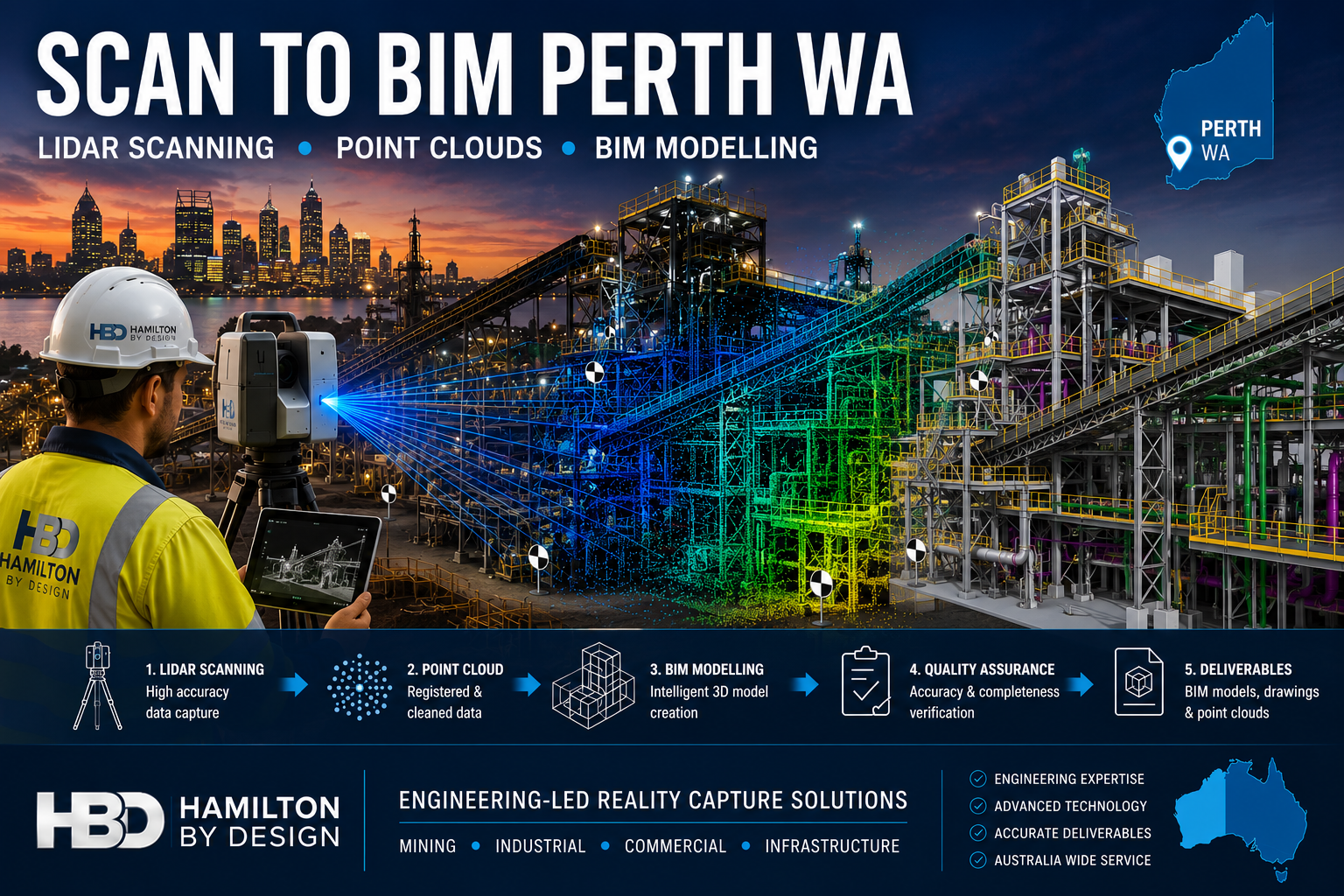
Scan to BIM Perth WA engineering workflow showing LiDAR scanning, point cloud processing and BIM modelling of a Western Australian industrial facility using Hamilton By Design reality capture services.

Scan to BIM Perth WA

Engineering-Led Scan to BIM Services Across Perth and Western Australia

Hamilton By Design provides professional Scan to BIM services throughout Perth and Western Australia, helping mining, industrial, commercial, infrastructure and construction organisations transform accurate 3D laser scan data into intelligent Building Information Models (BIM).

Using engineering-grade LiDAR scanning technology and advanced BIM workflows, we capture existing facilities, process plants, buildings and infrastructure assets and convert them into accurate digital models suitable for design, planning, construction and asset management.

Whether your project involves a brownfield mining upgrade in the Pilbara, a commercial building in the Perth CBD, a processing plant in Kwinana or infrastructure works across regional Western Australia, our Scan to BIM services deliver reliable information for better engineering and project outcomes.


What is Scan to BIM?

Scan to BIM is the process of converting 3D laser scan data into an intelligent Building Information Model.

The process begins with high-accuracy LiDAR scanning, which captures millions of measurement points across a site. This data forms a point cloud that accurately represents existing conditions.

The point cloud is then used to create a BIM model containing structural, architectural and mechanical information that can be used throughout the project lifecycle.

The result is a highly accurate digital representation of the asset that supports:

  • Engineering design
  • Construction planning
  • Asset management
  • Facility upgrades
  • Maintenance planning
  • Clash detection
  • Digital twin development

Engineering-Led BIM Modelling

Unlike many scanning providers that focus only on data capture, Hamilton By Design combines engineering experience with reality capture technology.

This means the final BIM model is developed with an understanding of:

  • Mechanical systems
  • Structural steel
  • Conveyors
  • Chutes
  • Tanks
  • Pipework
  • Platforms and access systems
  • Process equipment
  • Material handling infrastructure

Our engineering background allows us to understand how facilities operate and how accurate models can improve future design decisions.


Perth Industries Using Scan to BIM

Mining and Resources

Western Australia remains one of the world’s largest mining regions.

Scan to BIM supports:

  • Iron ore facilities
  • Gold processing plants
  • Lithium operations
  • Rare earth projects
  • Bulk material handling systems
  • Port infrastructure

Accurate BIM models help engineering teams reduce shutdown durations and improve planning for plant upgrades.


Industrial Manufacturing

Many Perth manufacturers operate facilities that have evolved over decades.

Often existing drawings are incomplete or outdated.

Scan to BIM enables:

  • Accurate facility documentation
  • Equipment replacement projects
  • Structural upgrades
  • Capacity expansion projects
  • Maintenance planning

Commercial Buildings

Commercial property owners increasingly use BIM models to manage assets.

Applications include:

  • Building refurbishment
  • Services upgrades
  • HVAC replacement
  • Tenant fit-outs
  • Facility management

Infrastructure Projects

Scan to BIM can support:

  • Rail infrastructure
  • Ports
  • Water treatment facilities
  • Pump stations
  • Utility corridors
  • Government infrastructure

Accurate BIM models reduce project risk by ensuring designs are based on real-world conditions.


Our Scan to BIM Workflow

1. Site LiDAR Scanning

We perform engineering-grade laser scanning using professional reality capture equipment.

Millions of measurement points are collected across the facility.


2. Point Cloud Registration

Individual scans are aligned and processed into a unified point cloud.

Typical deliverables include:

  • E57
  • RCP
  • RCS
  • LAS

3. BIM Model Development

The point cloud is converted into BIM geometry using industry-standard software.

Models may include:

  • Structural steel
  • Mechanical equipment
  • Pipework
  • Buildings
  • Platforms
  • Access systems

4. Quality Assurance

Models are checked against scan data to verify accuracy and completeness.


5. Deliverables

Typical outputs include:

  • Autodesk Revit Models
  • Navisworks Models
  • IFC Files
  • DWG Drawings
  • PDF Documentation
  • Point Cloud Files

Benefits of Scan to BIM

Improved Accuracy

Laser scanning captures existing conditions with significantly greater accuracy than traditional site measurement methods.

Reduced Design Risk

Design teams can work from verified information rather than assumptions.

Faster Project Delivery

Accurate digital models reduce site revisits and minimise redesign.

Better Asset Management

Facility owners gain an accurate digital representation of their assets.

Improved Collaboration

BIM models provide a common source of information for engineers, designers, contractors and asset owners.


Scan to BIM for Brownfield Mining Projects

Brownfield projects often present unique challenges.

Existing facilities may contain undocumented modifications, ageing infrastructure and limited historical records.

Scan to BIM allows engineering teams to:

  • Verify existing conditions
  • Identify clashes before construction
  • Reduce shutdown risks
  • Improve design confidence
  • Support future digital twin initiatives

For mining operations throughout Perth, the Pilbara, Goldfields and regional Western Australia, accurate BIM models can significantly improve project outcomes.


Why Choose Hamilton By Design?

Hamilton By Design combines:

โœ” Engineering Experience

โœ” LiDAR Scanning Expertise

โœ” BIM Modelling Capability

โœ” Mechanical Design Knowledge

โœ” Structural Drafting Experience

โœ” Australia-Wide Project Delivery

โœ” Mining Industry Experience

We understand both the technology and the engineering requirements behind successful Scan to BIM projects.


Hamilton By Design logo displayed on a blue tilted rectangle with a grey gradient background

Scan to BIM Perth WA

If you require Scan to BIM services in Perth or anywhere across Western Australia, Hamilton By Design can provide engineering-grade reality capture and BIM modelling solutions tailored to your project requirements.

From mining facilities and industrial plants to commercial buildings and infrastructure projects, we help organisations capture existing conditions and create accurate digital models that support safer, more efficient project delivery.

Talk to Us – Contact Us

Name
Would you like us to arrange a phone consultation for you?
Address

Our clients:

3D LiDAR Scanning Darwin for engineering surveys, laser scanning, reality capture and point cloud modelling services
3D LiDAR Scanning Australia engineering services for laser scanning, reality capture, scan-to-CAD, Scan-to-BIM and as-built documentation across Australia
3D LiDAR scanning services on the Central Coast providing engineering-grade laser scanning, point cloud capture, scan-to-CAD modelling and industrial reality capture for infrastructure and industrial projects.
3D LiDAR Scanning Perth for engineering surveys, laser scanning, reality capture and point cloud modelling services
3D LiDAR Scanning Sydney for engineering surveys, laser scanning, reality capture and point cloud modelling services
3D LiDAR Scanning Brisbane for engineering surveys, laser scanning, reality capture and point cloud modelling services
3D LiDAR Scanning Canberra for engineering surveys, laser scanning, reality capture and point cloud modelling services
3D LiDAR Scanning Newcastle for engineering surveys, laser scanning, reality capture and point cloud modelling services
3D LiDAR Scanning Adelaide for engineering surveys, laser scanning, reality capture and point cloud modelling services

Brownfield Costโ€“Benefit: Engineering Design vs Continuous Navisworks Model Maintenance

Executive Summary

In brownfield projects, the highest return comes from applying engineering design effort at the point of change, supported by accurate point cloud data, rather than continuously updating a federated model.

The practical reality is:

Invest in engineering decisions, not in maintaining a model that becomes outdated faster than the plant changes.


3D LiDAR scanning and 3D modelling service button โ€” laser scanner capturing a point cloud for engineering and CAD modelling
Mechanical engineering services

Two Approaches

1. Model Maintenanceโ€“Centric (Navisworks)

Using Autodesk Navisworks Manage as an ongoing platform:

  • Maintain a full federated model
  • Update after every site change
  • Re-run coordination and clash detection
  • Manage model alignment across disciplines

2. Engineering-Driven (Point Cloud + Targeted CAD)

Using:

  • FARO SCENE
  • SOLIDWORKS eDrawings
  • Capture and retain point cloud data as the primary asset
  • Model only what is being modified
  • Use CAD and drawings for fabrication and communication

Cost Drivers

Navisworks Model Maintenance

  • Initial model creation and federation
  • Continuous updates after modifications
  • Data conversion and reprocessing
  • Coordination meetings and clash resolution
  • Ongoing QA and model validation

Additional hidden costs include:

  • Model drift corrections
  • Rework due to mismatch with site conditions
  • Reliance on a limited number of trained users

Engineering-Driven Workflow

  • Targeted scanning where required
  • Point cloud processing and validation
  • Engineering design effort for modifications
  • Drawing and component model production

Additional benefits include:

  • Reusable scan data
  • No requirement to maintain a full plant model
  • Faster response to site-driven changes

3D CAD Modelling Australia service banner for Hamilton By Design

Benefit Comparison

Navisworks model maintenance offers strong upfront coordination, particularly in greenfield projects, but suffers from degradation over time and high ongoing cost.

Engineering-driven workflows using point cloud data provide higher long-term accuracy, faster turnaround for small changes, and better alignment with real site conditions.


Line-of-Sight Reality

Point cloud data is inherently line-of-sight dependent. This means:

  • Only visible surfaces are captured
  • Occlusions result in gaps in the dataset

This limitation exists regardless of software platform.

Importing a point cloud into Navisworks does not improve data completeness or accuracy โ€” it simply presents the same data in a different environment.


Practical Example

For a minor electrical upgrade:

Navisworks Approach

  • Update the federated model
  • Re-run coordination
  • Issue revised model
  • Proceed with installation

This introduces significant overhead for a simple task.


Engineering Approach

  • Review point cloud or site conditions
  • Confirm clearances
  • Design locally
  • Install
  • Update drawings if required

This approach is faster, lower cost, and aligned with how work is actually executed.


Where Navisworks Adds Value

Navisworks remains effective when:

  • Multiple disciplines are designing simultaneously
  • Large-scale coordination is required
  • Clash detection is critical

This typically applies to:

  • Greenfield projects
  • Major brownfield upgrades

It should be treated as a project-phase coordination tool, not a long-term data management system.


  • Use point cloud data as the primary reference
  • Maintain raw and registered datasets (e.g. E57)
  • Model only critical interfaces and new work
  • Use drawings for formal deliverables
  • Apply Navisworks selectively where coordination is required

Final Position

In brownfield environments, value is created through engineering design and decision-making, not through continuous model maintenance.


One-Line Summary

Design what youโ€™re changing. Scan what youโ€™re keeping. Donโ€™t model what you wonโ€™t maintain.

Our clients

Talk to Us – Contact Us

Name
Would you like us to arrange a phone consultation for you?
Address
CHPP Engineering title graphic featuring bold white text reading "CHPP Engineering" centred on a blue rounded rectangle background.
Pipework Drafting title graphic featuring bold white text reading "Pipework Drafting" centred on a blue rounded rectangle background.
3D LiDAR Scanning for Engineering Projects title graphic featuring bold white text on a blue rounded rectangle background.






































