Systems Engineering, Hazard Identification and Mining Safety

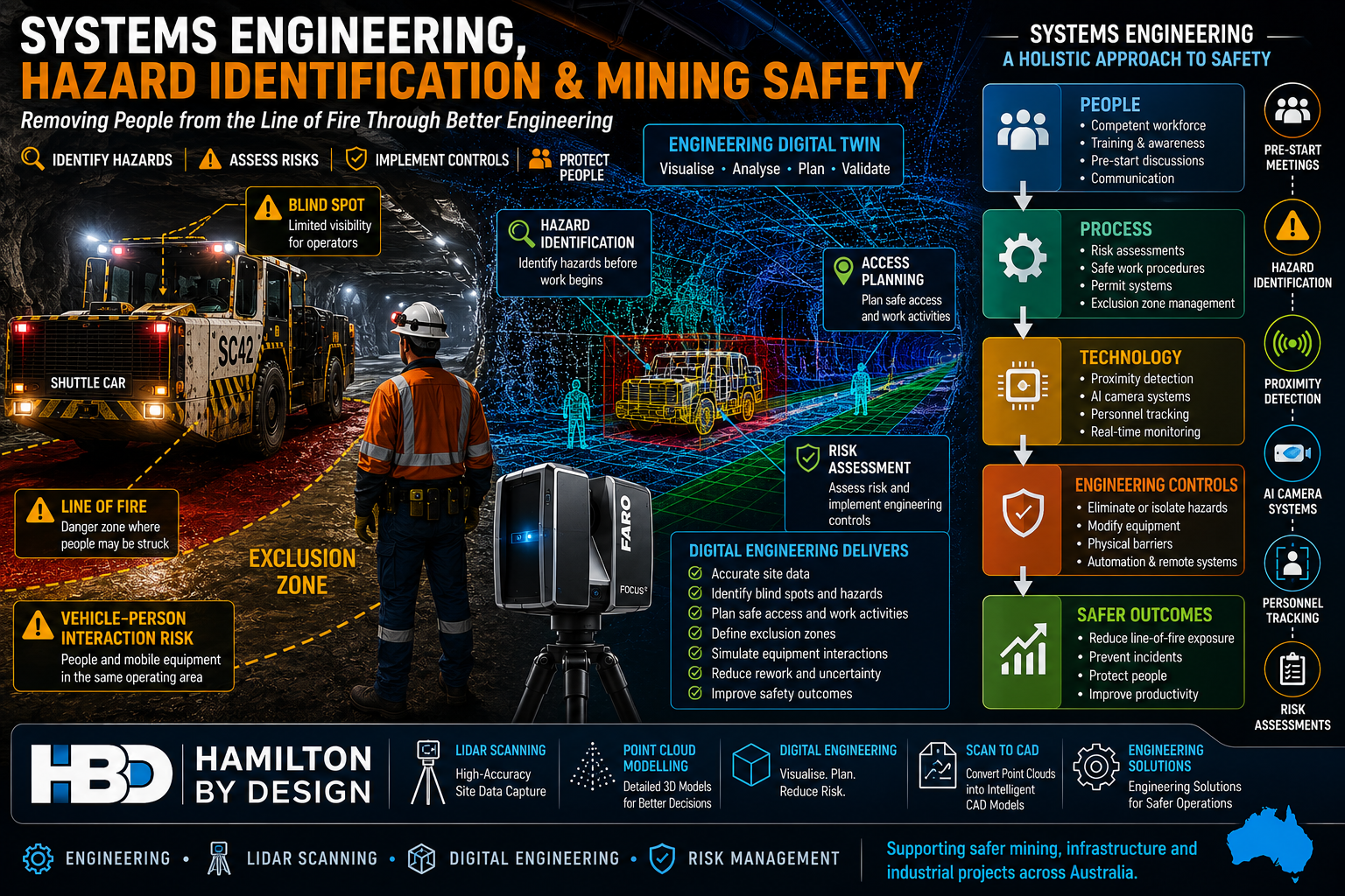
Systems engineering and mining safety infographic showing an underground shuttle car, exclusion zones, hazard identification, engineering digital twin, LiDAR scanning, risk assessment and engineering controls used to reduce line-of-fire risks and improve workplace safety in mining operations.

Lessons from a Preventable Underground Coal Mine Incident

The Technology Exists โ€“ So Why Are We Still Seeing These Incidents?

A recent Resources Safety & Health Queensland (RSHQ) investigation into a near-fatal underground coal mining incident has once again highlighted a challenge that continues to confront the mining industry.

The incident occurred at an underground coal mine near Emerald in Queensland’s Bowen Basin when a worker entered the blind spot of a shuttle car and was struck by the machine. Investigators identified several contributing factors including poor visibility, inadequate communication, high background noise, blind spots around mobile equipment and the absence of proximity detection technology. RSHQ described the event as entirely preventable and encouraged operators to consider technologies already being used successfully at other Queensland mines.

While incidents such as this are often discussed from an operational perspective, they also highlight a broader engineering challenge.

The real question is:

How do we design systems that prevent workers from being exposed to hazards in the first place?

This is where systems engineering becomes critically important.


What is Systems Engineering?

Systems engineering is the disciplined approach of understanding how people, equipment, processes, technology, procedures and the operating environment interact as a complete system.

Rather than focusing on individual components, systems engineering examines:

  • Human factors
  • Equipment design
  • Communication systems
  • Work procedures
  • Environmental conditions
  • Technology controls
  • Organisational culture
  • Training and competency
  • Risk management processes

When a serious incident occurs, it is rarely caused by a single failure.

Instead, multiple weaknesses align simultaneously.

In the Emerald incident, the shuttle car itself was not necessarily defective.

The system failed because:

  • Workers changed position without positive communication.
  • The vehicle operator was unaware of the workers’ location.
  • Visibility was limited.
  • Background noise masked movement.
  • No proximity detection technology was available.
  • Workers entered a line-of-fire zone.

A systems engineering approach asks:

What combination of controls could have prevented the event regardless of human error?


The Hierarchy of Controls

One of the most important principles in safety engineering is the Hierarchy of Controls.

Controls are generally ranked from most effective to least effective:

  1. Elimination
  2. Substitution
  3. Engineering Controls
  4. Administrative Controls
  5. Personal Protective Equipment

Many organisations rely heavily on procedures, training and pre-start discussions.

While these are important, they sit relatively low in the hierarchy.

Engineering controls are often more reliable because they do not depend entirely on human behaviour.

Examples include:

  • Proximity detection systems
  • AI camera systems
  • Collision avoidance systems
  • Personnel tracking systems
  • Physical barriers
  • Interlocks
  • Remote operation technology
  • Autonomous equipment

The objective should always be to engineer hazards out of the system wherever practical.


Hazard Identification Starts Before Work Begins

One of the most effective safety tools available is proactive hazard identification.

Many incidents occur because hazards are recognised only after work has commenced.

Hazard identification should occur during:

Project Planning

Before construction or maintenance work begins.

Design Reviews

Before equipment is fabricated or modified.

Shutdown Planning

Before personnel enter operational areas.

Pre-Start Meetings

Before workers commence each shift.

Field Risk Assessments

Immediately before performing a task.

A robust hazard identification process considers:

  • Mobile equipment interactions
  • Blind spots
  • Stored energy
  • Working at heights
  • Falling objects
  • Confined spaces
  • Vehicle movements
  • Emergency access
  • Simultaneous operations
  • Human factors

The goal is simple:

Identify hazards before they have an opportunity to cause harm.


Why Pre-Start Meetings Matter

In many operations, pre-start meetings can become routine.

Unfortunately, routine often leads to complacency.

The most effective pre-start meetings are not simply administrative exercises.

They provide an opportunity to discuss:

What Has Changed?

  • New equipment
  • New personnel
  • Different environmental conditions
  • Weather impacts
  • Operational changes

What Are Today’s Hazards?

  • Vehicle interactions
  • Exclusion zones
  • Ground conditions
  • Overhead hazards
  • Isolation requirements

What Are the Critical Controls?

  • Spotters
  • Communication methods
  • Isolation procedures
  • Permit requirements
  • Emergency response arrangements

What Could Go Wrong?

This question alone can significantly improve hazard awareness.

A quality pre-start discussion encourages workers to actively think about risk before entering the workplace.


Line-of-Fire Hazards Remain a Major Industry Risk

Across mining, construction, manufacturing and heavy industry, line-of-fire incidents continue to be one of the leading causes of serious injury and fatalities.

Line-of-fire hazards include situations where workers are exposed to:

  • Moving vehicles
  • Rotating equipment
  • Suspended loads
  • Stored energy
  • Pressurised systems
  • Falling objects
  • Uncontrolled equipment movement

Recent Queensland mining safety alerts have repeatedly highlighted similar themes:

  • Workers trapped between vehicles.
  • Workers entering exclusion zones.
  • Poor communication.
  • Lack of positive isolation.
  • Mobile equipment interactions.

The underlying hazards are often well understood.

The challenge is ensuring controls remain effective in real-world operating environments.


The Role of Digital Engineering and LiDAR Scanning

Modern engineering tools are creating new opportunities to identify and manage risk before work begins.

Engineering-grade LiDAR scanning and digital engineering workflows allow project teams to create accurate digital representations of operational facilities.

Applications include:

Access Planning

Identifying safe access routes.

Equipment Interaction Analysis

Assessing vehicle and personnel separation.

Shutdown Planning

Visualising work fronts before crews arrive onsite.

Clash Detection

Identifying conflicts before installation.

Exclusion Zone Development

Understanding hazardous interaction areas.

Emergency Planning

Reviewing evacuation routes and emergency access.

Hamilton By Design regularly supports projects through:

  • Engineering-grade LiDAR scanning
  • Point cloud modelling
  • Scan-to-CAD workflows
  • Digital engineering
  • Mechanical engineering
  • Brownfield modifications
  • As-built documentation

These tools provide project teams with accurate information that can improve both productivity and safety outcomes.


Proximity Detection Technology is Not New

One of the most significant observations from the recent incident is that proximity detection technology already exists.

In fact, underground mining industries have been investigating and deploying proximity detection systems around continuous miners and shuttle cars for many years. These systems can identify personnel entering predefined warning or hazard zones and initiate alarms, slowdowns or machine intervention depending on the system design.

Modern systems can provide:

  • Warning zones
  • Slow-down zones
  • Automatic stop functions
  • Personnel tracking
  • Vehicle interaction monitoring
  • AI-assisted hazard detection

The question is no longer whether the technology is available.

The question is how quickly and consistently industry adopts it.


Building Safer Systems

A mature safety culture understands that procedures alone are rarely enough.

The strongest organisations focus on building multiple layers of protection.

This includes:

People

  • Training
  • Competency
  • Communication

Processes

  • Risk assessments
  • Safe work procedures
  • Permit systems

Technology

  • Proximity detection
  • AI vision systems
  • Personnel tracking

Engineering

  • Equipment redesign
  • Physical barriers
  • Elimination of hazards

Leadership

  • Safety culture
  • Accountability
  • Continuous improvement

When these elements work together, the likelihood of serious incidents is dramatically reduced.


Final Thoughts

The recent underground coal mining incident serves as a powerful reminder that safety is fundamentally a systems engineering challenge.

The objective should not simply be to react to incidents.

The objective should be to design work environments where incidents are far less likely to occur.

Hazard identification, risk assessment, effective pre-start meetings, engineering controls and modern technologies all play a critical role in achieving this outcome.

As the mining industry continues to embrace digital engineering, LiDAR scanning, automation, AI systems and proximity detection technologies, there is a significant opportunity to remove people from the line of fire and create safer workplaces.

The technology exists.

The challenge is ensuring it is implemented before the next near miss becomes a fatality.


Hamilton By Design logo displayed on a blue tilted rectangle with a grey gradient background

References

  1. Resources Safety & Health Queensland (RSHQ) โ€“ Safety Alert: Underground shuttle car incident.
  2. Resources Safety & Health Queensland (RSHQ) โ€“ Vehicle interaction and line-of-fire safety alerts.
  3. Proximity Detection Systems in Underground Mines โ€“ Queensland Mining Industry Health and Safety Conference.
  4. Proximity Detection Options on Underground Mining Equipment.
  5. Safe to Work โ€“ Coal mine collision highlights parking procedure risks.

Contact Us – Talk to Us

Name
Would you like us to arrange a phone consultation for you?

Address
Australian Drafting logo featuring bold white text reading "Australian Drafting" centred on a blue rounded rectangle background.
Engineering Governance title graphic featuring bold white text reading "Engineering Governance" centred on a blue rounded rectangle background.
Mechanical, Structural & Pipework Drafting service banner by Hamilton By Design featuring white text on a blue background.
Mechanical engineering services
Blue rounded button with the text โ€œSolidWorks Designโ€ in white.
Finite Element Analysis (FEA) engineering simulation button
3D LiDAR Scanning Darwin for engineering surveys, laser scanning, reality capture and point cloud modelling services
3D LiDAR Scanning Australia engineering services for laser scanning, reality capture, scan-to-CAD, Scan-to-BIM and as-built documentation across Australia
3D LiDAR scanning services on the Central Coast providing engineering-grade laser scanning, point cloud capture, scan-to-CAD modelling and industrial reality capture for infrastructure and industrial projects.
3D LiDAR Scanning Perth for engineering surveys, laser scanning, reality capture and point cloud modelling services
3D LiDAR Scanning Sydney for engineering surveys, laser scanning, reality capture and point cloud modelling services
3D LiDAR Scanning Brisbane for engineering surveys, laser scanning, reality capture and point cloud modelling services
3D LiDAR Scanning Canberra for engineering surveys, laser scanning, reality capture and point cloud modelling services
3D LiDAR Scanning Newcastle for engineering surveys, laser scanning, reality capture and point cloud modelling services
3D LiDAR Scanning Adelaide for engineering surveys, laser scanning, reality capture and point cloud modelling services

Designing for Developing Hazards: Lessons from the Derrimut Crane Collapse

Designing for Developing Hazards

Crane accidents are among the most visible reminders of the risks inherent in construction. The collapse of a crane at a data centre site in Derrimut, Melbourne, brought attention once again to the vulnerability of temporary lifting structures. While formal investigations are still underway, and no conclusions should be drawn prematurely, the event provides a valuable opportunity for reflection within the engineering community.

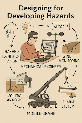
This article considers the collapse not as an isolated failure but as a case study in hazard identification. In particular, it highlights how mechanical engineers must adapt from a static, design-phase view of risk to a dynamic, real-time approach to hazard monitoring. Wind, soil stability, and load conditions are well-known hazards. But with modern tools โ€” including LiDAR scanning for obstacle detection โ€” engineers can move toward a future where developing hazards are continuously tracked, anticipated, and controlled.

From Hazard Identification to Live Hazard Monitoring

Hazard identification has traditionally been a design-phase process: engineers anticipate risks, apply safety factors, and create conservative margins. This remains essential. Yet the Derrimut collapse illustrates the limits of a static model in a dynamic environment.

Cranes are exposed to evolving hazards:

  • Wind gusts that change minute by minute.
  • Soil stability that shifts with rainfall, excavation, or groundwater.
  • Obstacles such as power lines or nearby structures, which can create cascading risks if struck.
  • Load dynamics, including swinging or sudden movement.

What is needed is a transition from hazard identification to hazard monitoring: a continuous loop where design assumptions are validated against real-time data, and where developing risks are detected before they become failures.

Wind Hazards: Predicting the Unpredictable

Wind is a leading cause of crane collapses. Engineers know the mathematics: pressure rises with the square of velocity. A 50 km/h gust exerts twice the force of a 35 km/h breeze.

Most cranes today are fitted with anemometers and alarms, but these are often basic: a single reading at a single point, with alarms sounding when preset thresholds are exceeded. This approach can miss:

  • Local gust variability along a long jib.
  • Interaction with crane orientation (wind hitting the broadside is more critical than aligned wind).
  • Forecasted conditions that could deteriorate within minutes.

Next-generation wind monitoring could include:

  • Multi-point sensor arrays on cranes.
  • Integration with Bureau of Meteorology gust forecasts.
  • AI models predicting when risk thresholds will be exceeded, not just reporting when they are crossed.
  • Automatic crane repositioning to minimise wind exposure.

This transforms alarms from reactive to predictive โ€” the difference between warning after a hazard is present and anticipating before it materialises.


Soil Hazards: Stability Under Load

Ground conditions are another silent but critical hazard. Outriggers may impose hundreds of kilonewtons on pads, meaning even small soil weaknesses can lead to tilting or overturning.

Engineering practice already includes soil investigations: boreholes, CPT, SPT, and FEA models. But these tests capture conditions before installation, not necessarily during operation. Soil strength can change due to rainfall, groundwater shifts, or nearby excavation.

Live soil monitoring can be achieved with:

  • Load cells under mats to track ground reactions.
  • Settlement gauges to detect tilt.
  • Piezometers for pore pressure during rain events.
  • Integrated warnings when ground resistance trends downward.

This approach acknowledges soil as a living hazard that changes daily.

LiDAR and Obstacle Detection: Power Lines and Proximity Hazards

One striking feature of the Derrimut collapse was the craneโ€™s boom striking power lines. Contact with utilities is a recurrent hazard in crane operations worldwide. While operators are trained to maintain exclusion zones, in practice visibility, fatigue, or unexpected boom movement can still lead to contact.

LiDAR scanning offers a solution.

  • How it works: LiDAR (Light Detection and Ranging) emits laser pulses to map surroundings in 3D with centimetre accuracy. Mounted on a crane, it can create a live digital map of nearby obstacles.
  • Application in cranes:
    • Detecting and mapping power lines, buildings, or scaffolding in the lift path.
    • Setting proximity alarms when a boom, hook, or load approaches a defined clearance.
    • Combining with wind data to predict if gusts could push the load into restricted zones.

In aviation, LiDAR and radar-based systems are standard for obstacle detection. In construction, adoption is patchy. Yet the technology exists, is cost-effective, and could dramatically reduce risks of contact with hazards like live power lines.

LiDARโ€™s strength lies not only in static mapping but in detecting movement โ€” for example, when a suspended load begins to swing toward a power line due to a gust. This is a quintessential developing hazard, one that static design could never fully capture.

Integrated Hazard Dashboards

Wind, soil, and LiDAR obstacle detection all provide valuable data. But their true power lies in integration. Imagine a crane operatorโ€™s cabin equipped with a single dashboard displaying:

  • Wind speeds and gust forecasts, colour-coded for risk.
  • Soil reaction forces under each outrigger, with alerts if settlement is trending.
  • LiDAR mapping of nearby structures and power lines, with real-time clearance zones.
  • Predictive risk models showing probability of instability or contact over the next 30 minutes.

This integration mirrors aviationโ€™s cockpit: multiple inputs fused into actionable guidance. For cranes, such systems could shift the operatorโ€™s role from reactive decision-maker to proactive risk manager.


AI as a Predictive Partner

Artificial Intelligence has a natural role in hazard monitoring:

  • Sensor fusion: combining wind, soil, and LiDAR inputs into coherent risk profiles.
  • Prediction: learning from past crane incidents to forecast when risks are likely to escalate.
  • Decision support: providing operators with clear options (โ€œsafe to continue lift for 20 minutesโ€ / โ€œhalt operations โ€” clearance margin < 1mโ€).

The challenge is balance. AI should not replace human oversight, but augment it. Over-reliance could create new vulnerabilities if operators become complacent. The design challenge is to build AI into systems that support human judgment rather than substitute for it.


Ethics and Engineering Responsibility

The Derrimut collapse underscores the ethical responsibility of mechanical engineers. Hazard identification is not just a design requirement; it is a matter of public safety. The profession has a duty to anticipate, detect, and control risks wherever possible.

The tools now exist to monitor developing hazards โ€” wind sensors, soil gauges, LiDAR scanners, and AI dashboards. If lives and infrastructure can be protected through wider adoption of these tools, then the question becomes one of responsibility: should they be optional, or mandatory?

Open Questions for the Future

  1. Would integrated live monitoring have reduced the risks at Derrimut?
  2. Should all cranes be fitted with LiDAR obstacle detection as standard?
  3. Do we already have enough technology, but lack regulation and enforcement?
  4. What role should AI play in balancing predictive insight with operator autonomy?

The Derrimut incident remains under investigation. No conclusions can be drawn about its specific cause until findings are published. Yet as a case study, it illustrates the broader point that hazards in crane operations are dynamic. Wind, soil, obstacles, and loads evolve minute by minute.

Mechanical engineers have the tools โ€” wind sensors, soil monitors, LiDAR scanners, integrated dashboards, and AI โ€” to detect these developing hazards. The challenge is to move from a culture of static design assumptions to one of continuous hazard monitoring.

The ultimate professional question is this: If aviation can integrate multiple systems to monitor and predict hazards, why canโ€™t construction do the same for cranes? And if we can, how soon will we accept the ethical responsibility to make it standard?

References and Further Reading

  • ISO 4301 / AS 1418 โ€” Crane standards covering stability and wind.
  • ISO 12480-1:2003 โ€” Safe use of cranes; includes environmental hazard monitoring.
  • WorkSafe Victoria Guidance Notes โ€” Crane safety management.
  • Holickรฝ & Retief (2017) โ€” Probabilistic treatment of wind action in structural design.
  • Nguyen et al. (2020) โ€” Real-time monitoring of crane foundation response under variable soil conditions.
  • Liebherr LICCON โ€” Example of integrated load and geometry monitoring.
  • FAA LLWAS โ€” Aviationโ€™s real-time wind shear alert system, model for construction.
  • Recent research in LiDAR obstacle detection (e.g., IEEE Transactions on Intelligent Transportation Systems) โ€” showing LiDARโ€™s potential in complex environments.
Hamilton By Design logo displayed on a blue tilted rectangle with a grey gradient background
3D LiDAR scanning and 3D modelling service button โ€” laser scanner capturing a point cloud for engineering and CAD modelling
Mechanical engineering services

Our clients:

Name
Would you like us to arrange a phone consultation for you?
Address

Structural Drafting

3D CAD Modelling Australia service banner for Hamilton By Design
Australian Drafting logo featuring bold white text reading "Australian Drafting" centred on a blue rounded rectangle background.
Engineering Governance title graphic featuring bold white text reading "Engineering Governance" centred on a blue rounded rectangle background.
Mechanical, Structural & Pipework Drafting service banner by Hamilton By Design featuring white text on a blue background.
Mechanical engineering services
Blue rounded button with the text โ€œSolidWorks Designโ€ in white.
Finite Element Analysis (FEA) engineering simulation button
3D LiDAR Scanning Darwin for engineering surveys, laser scanning, reality capture and point cloud modelling services
3D LiDAR Scanning Australia engineering services for laser scanning, reality capture, scan-to-CAD, Scan-to-BIM and as-built documentation across Australia
3D LiDAR scanning services on the Central Coast providing engineering-grade laser scanning, point cloud capture, scan-to-CAD modelling and industrial reality capture for infrastructure and industrial projects.
3D LiDAR Scanning Perth for engineering surveys, laser scanning, reality capture and point cloud modelling services
3D LiDAR Scanning Sydney for engineering surveys, laser scanning, reality capture and point cloud modelling services
3D LiDAR Scanning Brisbane for engineering surveys, laser scanning, reality capture and point cloud modelling services
3D LiDAR Scanning Canberra for engineering surveys, laser scanning, reality capture and point cloud modelling services
3D LiDAR Scanning Newcastle for engineering surveys, laser scanning, reality capture and point cloud modelling services
3D LiDAR Scanning Adelaide for engineering surveys, laser scanning, reality capture and point cloud modelling services

Mechanical Drafting

3D Laser Scanning

Mechanical Engineering

Consulting Engineers