Why Point Cloud Data Beats STL for Real Engineering Work

Point cloud to CAD workflow showing transition from STL mesh to engineering-ready parametric model with dimensions and drawings

In the world of 3D scanning, there is often confusion around what type of data is actually useful for engineering. Many providers offer high-accuracy scanning using metrology-grade equipment, yet the final deliverable is often limited to STL or OBJ files.

The question is simple:
If the data cannot be used inside your CAD system, what is its real value?


The Rise of Metrology-Grade Scanning

Modern handheld scanners are incredibly capable. They can capture fine detail, achieve high accuracy, and generate dense surface representations of components. These systems are often used in reverse engineering, product design, and inspection workflows.

They are frequently marketed as โ€œmetrology-grade,โ€ and in terms of capture capability, that claim is valid. These scanners can measure to very tight tolerances and produce highly detailed digital representations.

However, the real issue is not how the data is captured.
It is how the data is delivered and how it integrates into engineering workflows.

Capturing accurate data is only the first step. The true value lies in whether that data can be used to design, modify, verify, and manufacture real-world components.
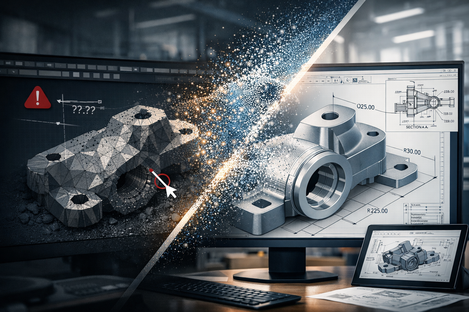

STL and OBJ โ€“ A Surface, Not a Solution

STL and OBJ files are mesh-based formats. They represent the surface of an object using thousands or millions of triangles stitched together to form a 3D shape.

These files are useful for:

  • Visualisation
  • 3D printing
  • Basic reference and communication

They are fast to generate and easy to share, which is why many scanning providers stop at this stage.

However, they come with significant limitations:

  • No parametric geometry
  • No selectable engineering features
  • No design intent
  • Difficult to dimension accurately
  • Cannot drive CAD models effectively

A mesh file is essentially a visual representation, not an engineering model.

In simple terms:

An STL file shows what something looks like, but not how to design, modify, or manufacture it.

Once the data is converted into a mesh, it is often smoothed, simplified, and processed. This means the original measured data is no longer fully preserved, and any measurements taken from the mesh are based on an interpreted surface rather than raw coordinates.


Engineering Happens in CAD

Real engineering work takes place inside platforms such as SolidWorks, Autodesk Inventor, Autodesk Fusion, and Onshape.

These tools are built around:

  • Parametric modelling
  • Feature-based design
  • Relationships and constraints
  • Editable geometry

They rely on identifiable features such as:

  • Planes
  • Cylinders
  • Holes
  • Edges and faces

Mesh files do not contain this level of intelligence. As a result, they cannot be easily used to:

  • Modify or optimise designs
  • Perform engineering calculations or simulations
  • Generate fabrication-ready drawings
  • Maintain consistency across revisions

This creates a disconnect:

You can measure on the scanner, but you cannot effectively design in CAD.

And if design cannot happen in CAD, the workflow breaks down.


The Advantage of Point Cloud Data

Point cloud data, typically delivered in formats such as E57 or RCP, captures real-world coordinates directly from the scan. Each point represents a measurable location in 3D space.

This is fundamentally different from a mesh.

Point clouds provide:

  • True measured data (not interpreted surfaces)
  • High-density spatial accuracy
  • Full capture of the environment or component
  • The ability to revisit and re-measure at any time

This enables engineers to:

  • Extract accurate dimensions directly from real-world data
  • Fit geometry (planes, cylinders, centre lines) inside CAD
  • Validate designs against existing conditions
  • Maintain traceability and confidence in the data

Point clouds form the foundation for engineering-grade modelling, not just visual representation.


From Scan to Engineering Outcome

At Hamilton By Design, the focus is not just on capturing data, but on delivering usable engineering outcomes.

Our workflow is:

Scan โ†’ Point Cloud โ†’ CAD Model โ†’ Engineering Drawings

This ensures the data can be:

  • Measured inside CAD
  • Verified and checked against real conditions
  • Modified to suit design requirements
  • Used for fabrication, installation, and real-world implementation

This approach bridges the gap between reality and design.

It turns captured data into something that engineers, fabricators, and project teams can actually use.


Like-for-Like vs Design Flexibility

If your requirement is a like-for-like digital representation of an object, mesh files such as STL or OBJ may be sufficient.

They provide a quick and effective way to visualise shape and form.

However, if your goal is to:

  • Modify a design
  • Integrate with existing infrastructure
  • Produce engineering drawings
  • Support fabrication or installation

Then flexibility becomes critical.

If youโ€™re looking for like-for-like, mesh will get you there.
If youโ€™re looking for a flexible design tool, point cloud is the answer.


The Bottom Line

Metrology-grade scanners can capture extremely accurate data. But if that data is delivered only as an STL or OBJ file, its value is significantly limited within an engineering context.

True value comes from transforming scan data into something that works inside CAD and supports real-world outcomes.

Mesh files deliver a shape.
Point clouds deliver a foundation for engineering.

3D CAD Modelling Australia service banner for Hamilton By Design
Finite Element Analysis (FEA) engineering simulation button
Mechanical engineering services

Accuracy of LiDAR Scanning for Engineering Applications

Industrial engineer operating a LiDAR laser scanner capturing high-accuracy point cloud data of a processing plant for engineering design and infrastructure upgrades.

Modern engineering projects increasingly rely on accurate digital representations of existing infrastructure before design, fabrication, or modification begins. One of the most powerful technologies enabling this is LiDAR scanning (Light Detection and Ranging).

At Hamilton By Design, LiDAR scanning is used to capture engineering-grade point cloud data of industrial facilities, mining infrastructure, processing plants, and mechanical systems across Australia.

Understanding the accuracy of LiDAR scanning is essential for engineers, project managers, and asset owners when planning upgrades or modifications to existing facilities.


LiDAR scanning of industrial infrastructure with a 3D point cloud overlay showing engineering-grade measurement accuracy.

What is LiDAR Scanning?

LiDAR scanning works by emitting thousands of laser pulses per second. These pulses strike surrounding surfaces and return to the scanner, allowing precise calculation of distance.

The result is a dense three-dimensional point cloud that captures the exact geometry of an environment.

This digital dataset can then be used for:

โ€ข Engineering modelling
โ€ข Plant layout verification
โ€ข Clash detection
โ€ข Structural analysis
โ€ข Reverse engineering
โ€ข Retrofit design

At Hamilton By Design, these datasets are commonly converted into engineering models and SolidWorks design geometry using our established workflow.

Learn more about this process here:

Point Cloud to Engineering Model Workflow
https://www.hamiltonbydesign.com.au/point-cloud-to-engineering-model-workflow/


Typical Accuracy of Engineering LiDAR Scanning

The accuracy of LiDAR scanning depends on several factors including the scanner type, range to the object, scanning environment, and control methodology.

Typical engineering-grade terrestrial LiDAR systems achieve:

ParameterTypical Accuracy
Scanner measurement accuracyยฑ1 mm to ยฑ3 mm
Registered scan network accuracyยฑ2 mm to ยฑ6 mm
Large plant scan accuracyยฑ5 mm to ยฑ10 mm

For most industrial engineering applications, this level of accuracy is more than sufficient to support:

โ€ข Structural steel modifications
โ€ข Pipework routing and tie-ins
โ€ข Mechanical equipment installation
โ€ข Conveyor and materials handling upgrades
โ€ข Plant shutdown engineering works


Factors That Affect LiDAR Accuracy

Although LiDAR scanning can achieve extremely high accuracy, several practical factors influence final results.

Scan Resolution

Higher resolution scanning increases the number of measured points and improves detail, but also increases processing time and file size.

Distance to Target

Accuracy decreases slightly as the distance between the scanner and the object increases. Industrial scanning programs typically maintain distances between 5โ€“40 metres.

Scan Registration

Multiple scans must be aligned together to form a complete dataset. Proper registration and survey control ensures that the final point cloud remains accurate across large areas.

Surface Conditions

Highly reflective, transparent, or moving surfaces may introduce noise or missing data within the scan.


Why Accuracy Matters for Engineering Projects

Engineering projects often involve modifying existing assets that may have been constructed decades ago.

Original drawings may be missing, outdated, or inaccurate.

By capturing true existing conditions, LiDAR scanning reduces risk during design and construction.

Benefits include:

โ€ข Reduced site rework
โ€ข Fewer installation clashes
โ€ข Faster shutdown execution
โ€ข Improved fabrication accuracy
โ€ข Reduced project uncertainty

This is why many engineering teams now perform scanning before commencing plant upgrades.

Capture Existing Conditions Before Plant Upgrades
https://www.hamiltonbydesign.com.au/capture-existing-conditions-before-plant-upgrades/


LiDAR Scanning for Mining and Industrial Infrastructure

Industries where LiDAR scanning is particularly valuable include:

โ€ข Mining and mineral processing
โ€ข Water and wastewater facilities
โ€ข Power generation plants
โ€ข Heavy manufacturing facilities
โ€ข Materials handling systems

At Hamilton By Design, scanning is commonly used to support:

โ€ข Shutdown planning
โ€ข Structural modifications
โ€ข Mechanical equipment upgrades
โ€ข Brownfield engineering projects

Learn more about our scanning services across Australia:

Engineering Grade 3D Laser Scanning for Mining and Industrial Projects
https://www.hamiltonbydesign.com.au/home/engineering-grade-3d-laser-scanning-mining-industrial/


From Scan Data to Engineering Design

Once captured, LiDAR data becomes the foundation for digital engineering workflows.

Point clouds can be converted into:

โ€ข SolidWorks models
โ€ข Structural steel models
โ€ข Pipe routing layouts
โ€ข Mechanical equipment models
โ€ข Digital twins of plant infrastructure

This allows engineers to design modifications directly against the existing environment, dramatically reducing project risk.


Hamilton By Design logo displayed on a blue tilted rectangle with a grey gradient background

Conclusion

LiDAR scanning has become an essential tool for modern engineering projects, providing millimetre-level accuracy when capturing existing infrastructure.

When combined with experienced engineering workflows, LiDAR enables faster, safer, and more reliable plant upgrades.

At Hamilton By Design, we specialise in transforming high-accuracy LiDAR data into practical engineering models and design solutions for mining, industrial, and infrastructure projects.


Need LiDAR Scanning for Your Project?

Hamilton By Design provides engineering-grade 3D laser scanning services across Australia to support plant upgrades, shutdown projects, and infrastructure modifications.

Learn more about our services here:

3D LiDAR scanning and 3D modelling service button โ€” laser scanner capturing a point cloud for engineering and CAD modelling
Mechanical engineering services
Name
Would you like us to arrange a phone consultation for you?
Address
3D CAD Modelling Australia service banner for Hamilton By Design