3D CAD in Brisbane

3D CAD in Brisbane | Engineering-Led CAD Services
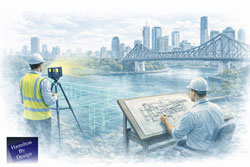
Brisbane is one of Australiaโ€™s most active centres for industrial, infrastructure, and brownfield development. From live manufacturing facilities and ports to mineral processing plants and inner-city construction, projects in South East Queensland demand 3D CAD models that reflect reality โ€” not assumptions.

Hamilton By Design provides engineering-led 3D CAD services in Brisbane, supporting mechanical, industrial, and construction projects where accuracy, constructability, and coordination are critical.


Engineering-led SolidWorks 3D CAD model overlaid on an industrial facility in Brisbane

Engineering-Led 3D CAD for Brisbane Projects

Our 3D CAD workflows are developed for environments where:

  • Existing structures must be retained or modified
  • Access is constrained or live operations continue
  • Fabrication tolerances matter
  • Errors translate directly into cost, downtime, or safety risk

Rather than producing conceptual or presentation-only models, our Brisbane CAD services focus on fit-for-purpose engineering outcomes โ€” models that can be trusted for fabrication, installation, and long-term asset management.


Scan-to-CAD: Accurate Models Built on Real Geometry

A defining feature of 3D CAD in Brisbane is the dominance of brownfield and upgrade projects. As-built information is often incomplete, outdated, or missing altogether.

To address this, our CAD services are tightly integrated with engineering-grade LiDAR scanning:

  • Existing conditions are captured using high-accuracy point cloud data
  • CAD models are built directly from site geometry
  • Interfaces with existing steel, plant, and services are verified early

This approach reduces clashes, rework, and site-based decision making.

For projects requiring detailed existing-conditions capture, our CAD services are commonly paired with:


Mechanical & Industrial 3D CAD Applications

Brisbaneโ€™s industrial profile shapes how 3D CAD is applied. Our Brisbane CAD projects commonly support:

  • Mechanical plant upgrades and retrofits
  • Conveyor systems and bulk materials handling
  • Manufacturing and FMCG production lines
  • Structural steel modifications
  • Access platforms, guarding, and maintenance systems

Models are developed with installation sequencing, access, and safety in mind โ€” not just geometry.


CAD That Supports Fabrication and Installation

In Brisbane projects, CAD is often the single source of truth shared between:

  • Engineers
  • Fabricators
  • Site teams
  • Project managers

Our 3D CAD deliverables are structured to support this environment, with:

  • Clear assemblies and interfaces
  • Fabrication-ready geometry
  • Alignment with engineering documentation and drawings
  • Compatibility with downstream analysis and verification

Where required, CAD models can be integrated with broader engineering services, including analysis, documentation, and compliance workflows.


Integration with Engineering & Reality Capture Services

3D CAD in Brisbane rarely exists in isolation. Our CAD services sit within a broader engineering context, including:

This integrated approach allows Brisbane clients to move from site capture to fabrication-ready models without fragmentation or loss of accountability.


Why Brisbane Projects Benefit from Engineering-Owned CAD

Brisbaneโ€™s mix of live industrial assets, ageing infrastructure, and complex construction environments means CAD decisions carry real-world consequences.

Our Brisbane CAD workflows are:

  • Engineer-owned, not drafting-only
  • Developed with site conditions in mind
  • Accountable to constructability and safety
  • Aligned with Australian Standards and industry best practice

This makes our CAD outputs suitable for use in shutdown planning, procurement, fabrication, and installation, not just design coordination.


3D CAD Services Across Greater Brisbane

We support projects across the greater Brisbane region, including:

  • Inner-city and CBD environments
  • Industrial estates and ports
  • Manufacturing precincts
  • Infrastructure and utilities corridors

Whether supporting a standalone upgrade or a larger engineering program, our 3D CAD services are structured to integrate smoothly into existing project teams.


Hamilton By Design logo displayed on a blue tilted rectangle with a grey gradient background
3D LiDAR scanning and 3D modelling service button โ€” laser scanner capturing a point cloud for engineering and CAD modelling
Mechanical engineering services

Discuss a 3D CAD Project in Brisbane

If you are planning an upgrade, retrofit, or new installation in Brisbane and require accurate, engineering-grade 3D CAD, we can support your project from early capture through to fabrication-ready deliverables.

Contact Hamilton By Design to discuss how our 3D CAD and scan-to-CAD services can reduce risk and improve outcomes on your Brisbane project.


Our clients


Name
Would you like us to arrange a phone consultation for you?
Address

3D CAD Modelling Australia service banner for Hamilton By Design


CHPP Engineering title graphic featuring bold white text reading "CHPP Engineering" centred on a blue rounded rectangle background.
Pipework Drafting title graphic featuring bold white text reading "Pipework Drafting" centred on a blue rounded rectangle background.
3D LiDAR Scanning for Engineering Projects title graphic featuring bold white text on a blue rounded rectangle background.


Finite Element Analysis (FEA) engineering simulation button
Structural drafting services button
Mechanical drafting services button


Australian Drafting logo featuring bold white text reading "Australian Drafting" centred on a blue rounded rectangle background.
Engineering Governance title graphic featuring bold white text reading "Engineering Governance" centred on a blue rounded rectangle background.
Engineering-Grade LiDAR Scanning title graphic featuring bold white text on a blue rounded rectangle background.


Mechanical drafting services button
Structural drafting services button


Fabrication and product design services
3D CAD Modelling Australia service banner for Hamilton By Design
Mechanical, Structural & Pipework Drafting service banner by Hamilton By Design featuring white text on a blue background.


3D LiDAR scanning and 3D modelling service button โ€” laser scanner capturing a point cloud for engineering and CAD modelling
Mechanical engineering services

3D Scanning Brisbane

Engineer completing structural drafting while a LiDAR scanner captures as-built data along the Brisbane River with the Story Bridge in view

3D Scanning Brisbane | Engineering-Led LiDAR & Risk Management


We are engineers. Let us manage your risk.

3D scanning is often treated as a visual exercise. In engineering, it is a measurement task. The difference matters.

At Hamilton By Design, 3D scanning in Brisbane is approached as an engineering activity, not just data capture. Our role is to ensure the information collected on site can be safely relied upon for design, fabrication, and installation โ€” without rework, uncertainty, or guesswork.


What People Mean When They Say โ€œ3D Scanningโ€

When someone searches for 3D scanning Brisbane, they are usually trying to answer one question:

โ€œHow do I measure what already exists?โ€

That might be to:

  • Capture existing site conditions
  • Reduce uncertainty before fabrication
  • Avoid clashes or rework on site

The challenge is that not all scanning methods actually measure geometry.


Cartoon showing a worker asking โ€œHow do I measure that?โ€ while looking at complex pipework, illustrating the need for accurate engineering-grade 3D scanning.

3D Scanning in Brisbane โ€“ Typical Use Cases

Across Brisbane and South-East Queensland, 3D scanning is commonly used for:

  • Industrial plant upgrades and brownfield sites
  • As-built capture of steel, services, and structures
  • Fabrication completed off-site
  • Retrofit works with limited access
  • Shutdown and tie-in planning

For projects like these, scanning is typically carried out using engineering-grade laser scanning, not visual or consumer-grade tools.
3D Laser Scanning


Scanning Is Not the Same as Measuring

(Simple cartoon here: character looking at an object asking โ€œHow do I measure that?โ€)

Scanning is not the same as measuring.
In fabrication, we measure twice and cut once.
With the right scanner, you only need to scan once.

Many scanning tools create models that look right but are based on inferred or smoothed geometry. For engineering, appearance is not enough โ€” the data must be measurable and accurate.


Not All 3D Scanning Is the Same

There are different ways to โ€œscanโ€ a site, each producing very different outcomes:

  • Phone and visual scans
    Useful for reference and visualisation, but not suitable for engineering.
  • Photogrammetry
    Good for context and large areas, but geometry is inferred rather than directly measured.
  • Engineering-grade LiDAR scanning
    Uses direct distance measurement to generate a true 3D point cloud.

Measured scan data can then be converted into usable engineering information through point cloud modelling workflows.
3D Point Cloud Modelling Brisbane


When Engineering-Grade Scanning Is Required

Engineering-grade scanning is required when:

  • Steelwork must fit first time
  • Pipework or spools are fabricated off-site
  • Structural members must be verified
  • Clearances and clashes carry cost or safety risk
  • There is only one opportunity to access the site

In these cases, scan data is typically followed by a Scan-to-CAD process, where point clouds are converted into accurate 3D models and drawings.
Scan to CAD Brisbane


Our Approach to 3D Scanning

Hamilton By Design treats scanning as part of a complete engineering workflow, not a standalone service.

Our approach includes:

  • Engineer-led scanning
  • Measurement-first mindset
  • Engineering-grade LiDAR equipment
  • Clear understanding of downstream use

By integrating scanning with mechanical engineering services, we maintain single-source accountability from site capture through to fabrication-ready deliverables.
Mechanical Engineering Services


What Happens After the Scan

3D scanning is the starting point, not the end.

Accurate scan data supports:

  • 3D CAD modelling
  • Fabrication and shop drawings
  • Structural verification
  • Clash detection and layout validation

Every downstream decision depends on the quality of the measurement captured at the start.


Talk to an Engineer Before You Scan

Many project issues begin with the wrong question:

โ€œCan you scan this?โ€

The better question is:

โ€œHow do I measure this so it can be engineered?โ€

If you need 3D scanning in Brisbane that can safely support engineering and fabrication decisions, Hamilton By Design can help you get it right the first time.


We are engineers. Let us manage your risk.


Hamilton By Design logo displayed on a blue tilted rectangle with a grey gradient background

Our clients:

Name
Would you like us to arrange a phone consultation for you?
Address
3D LiDAR scanning and 3D modelling service button โ€” laser scanner capturing a point cloud for engineering and CAD modelling
Mechanical engineering services
Finite Element Analysis (FEA) engineering simulation button
Mechanical engineering services

Reality Capture in the Hunter Valley

The Hunter Valley is one of Australiaโ€™s most technically complex industrial regions, combining power generation, mining, bulk materials handling, manufacturing, and logistics infrastructure within a tightly interconnected operational landscape. Projects in this environment frequently involve legacy assets, constrained access, and high consequences for design or construction error.

Reality capture in the Hunter Valley provides a structured, engineering-led method for documenting existing conditions using measured data rather than assumption-based interpretation. At Hamilton By Design, reality capture is applied as part of a broader engineering workflowโ€”ensuring captured information directly supports design development, upgrade planning, fabrication coordination, and risk management.


Defining reality capture in an industrial context

Reality capture is the process of recording physical site conditions using spatially accurate technologies and converting that information into usable engineering references. In practical terms, this includes:

  • Engineering-grade laser scanning and LiDAR acquisition
  • Spatial data registration and validation
  • Interpretation of existing geometry in the context of mechanical and structural systems
  • Translation of measured data into drawings, models, and coordination outputs

The objective is not simply to visualise a site, but to create a reliable, defensible representation of existing conditions that can be used throughout the project lifecycle.

For projects where laser scanning forms the core capture method, refer to:
3D Laser Scanning
https://www.hamiltonbydesign.com.au/home/3d-lidar-scanning-digital-quality-assurance/3d-laser-scanning/


Why reality capture is critical in the Hunter Valley

Industrial facilities across the Hunter Valley often operate continuously while upgrades, modifications, and expansions are undertaken. Common project challenges include:

  • Brownfield environments with incomplete or outdated documentation
  • Complex interfaces between mechanical, structural, and civil systems
  • Fabrication occurring off-site with limited tolerance for dimensional error
  • Restricted access windows and safety-critical operating conditions

In these scenarios, traditional measurement approaches are often insufficient. Reality capture reduces uncertainty by establishing a single source of measured truth, enabling informed decisions before fabrication or installation begins.

For an overview of how scanning is applied to regional industry, see:
3D Scanning for Industrial Projects in Newcastle and the Hunter Valley
https://www.hamiltonbydesign.com.au/3d-scanning-for-industrial-projects-in-newcastle-and-the-hunter-valley/


Typical Hunter Valley applications

Existing-condition baselining

Reality capture provides accurate documentation where legacy drawings no longer reflect actual site conditions. This baseline supports engineering assessments, upgrade feasibility studies, and staged project planning.

Plant upgrades and retrofit works

Measured spatial data allows new systems to be designed around existing plant, services, and structures, reducing clash risk and rework during installation.

Fabrication and construction coordination

Accurate capture of interfaces, clearances, and connection points improves alignment between design intent and fabricated componentsโ€”particularly where fabrication is completed remotely.

Risk reduction and decision support

From an engineering governance perspective, reality capture improves information quality, reduces assumptions, and supports more defensible technical decisions.


Engineering-led reality capture methodology

Hamilton By Design approaches reality capture as a project-specific engineering activity, not a generic surveying exercise.

1. Scope definition aligned to outcomes

Capture scope is defined based on how the data will be usedโ€”design development, drafting, verification, or coordinationโ€”ensuring the level of detail and accuracy is appropriate.

2. Structured site data acquisition

Capture activities are planned to manage occlusion, access limitations, and operational constraints commonly encountered on Hunter Valley industrial sites.

3. Data validation and preparation

Captured datasets are reviewed, registered, and structured so they can be confidently used for engineering interpretation rather than remaining as raw data.

4. Engineering-ready deliverables

Where required, reality capture outputs are converted into:

  • As-built drawings
  • General arrangement layouts
  • Reference models for coordination
  • Documentation suitable for engineering review and approvals

Relationship between reality capture and laser scanning

While laser scanning and LiDAR are commonly used tools within reality capture, the distinction lies in how the data is applied. Laser scanning provides the measurements; reality capture ensures those measurements are contextualised, validated, and integrated into engineering workflows.

This distinction is particularly important in industrial regions such as the Hunter Valley, where inaccurate interpretation of spatial data can have significant cost and safety implications.


Value for Hunter Valley stakeholders

Reality capture supports multiple stakeholder groups:

  • Asset owners and operators gain confidence in upgrade planning
  • Engineers work from verified existing-condition data
  • Fabricators receive clearer interface definitions
  • Project teams reduce site disruption and variation risk

From a systems engineering perspective, this represents an improvement in information reliability and traceabilityโ€”both key drivers of project performance.


Regional capability and service coverage

Hamilton By Design services the Hunter Valley as part of its broader NSW engineering and reality capture capability, supporting projects across industrial, energy, and infrastructure sectors.

Service coverage includes Newcastle and the wider Hunter region, as outlined in:
Frequently Asked Questions โ€“ Service Areas
https://www.hamiltonbydesign.com.au/frequently-asked-questions/


Next steps

For Hunter Valley projects, effective reality capture begins by clearly defining:

  1. Which areas and interfaces require measurement
  2. What engineering decisions the data must support
  3. The required accuracy for design, fabrication, or verification

Once these parameters are established, reality capture can be aligned to project risk, schedule, and delivery requirements.

For scanning-focused services, return to:
3D Laser Scanning
https://www.hamiltonbydesign.com.au/home/3d-lidar-scanning-digital-quality-assurance/3d-laser-scanning/

For industrial scanning examples in the region, see:
3D Scanning for Industrial Projects in Newcastle and the Hunter Valley
https://www.hamiltonbydesign.com.au/3d-scanning-for-industrial-projects-in-newcastle-and-the-hunter-valley/

3D LiDAR scanning and 3D modelling service button โ€” laser scanner capturing a point cloud for engineering and CAD modelling
Mechanical engineering services

Our clients:

Name
Would you like us to arrange a phone consultation for you?
Address

Darwin LiDAR & Laser Scanning Services

Industrial plant in Darwin being digitally captured with 3D scanning to support engineering design and upgrade planning.

Engineering-Grade Reality Capture for the Top End

Darwin projects operate in one of Australiaโ€™s most demanding environments. Remote logistics, extreme heat, cyclone exposure, corrosive coastal conditions and ageing infrastructure all place pressure on engineering projects to get it right the first time.

Hamilton By Design provides LiDAR and laser scanning services in Darwin that go beyond basic measurement. Our scanning is engineering-led, meaning data is captured with the end goal in mind โ€” mechanical design, structural verification, fabrication and construction.

This page complements our 3D Scanning Darwin landing page by focusing specifically on LiDAR and laser scanning and clearly explaining why these methods outperform traditional measurement techniques on Darwin-based projects.


What Is LiDAR & Laser Scanning?

LiDAR (Light Detection and Ranging) and terrestrial laser scanning use high-precision laser pulses to capture millions of spatial data points per second. These points form a 3D point cloud, accurately representing existing structures, plant, terrain and assets.

Unlike manual measurement, LiDAR captures entire environments, not just selected dimensions. This creates a permanent, revisit able digital record that engineers can interrogate long after leaving site.

In Darwin, where site access is costly and conditions are challenging, this capability is invaluable.


Why LiDAR & Laser Scanning Are Ideal for Darwin Projects

Darwin projects often involve:

  • Brownfield assets with poor documentation
  • Live facilities with limited access windows
  • Remote locations where repeat visits are expensive
  • Structures affected by corrosion, movement and deformation

LiDAR scanning directly addresses these challenges by replacing assumptions with measured reality.


LiDAR & Laser Scanning vs Traditional Measurement Methods

Traditional Measurement Methods

Common traditional approaches include:

  • Tape measures and laser distos
  • Total stations used selectively
  • Manual sketching and hand-marked dimensions
  • Assumptions based on legacy drawings

While these methods still have a place, they struggle in Darwinโ€™s complex industrial environments.


LiDAR & Laser Scanning โ€“ A Comparative Overview

AspectTraditional MethodsLiDAR & Laser Scanning
Data capturedLimited, selectiveMillions of points
AccuracyDepends on access & operatorConsistent, verifiable
Site timeHighReduced
Rework riskHighSignificantly reduced
Ability to revisit dataNoYes
SafetyManual access requiredReduced physical access
Suitability for brownfield sitesLimitedExcellent

Key Benefits of LiDAR & Laser Scanning in Darwin

1. Reduced Site Time in Remote Locations

Darwin projects often involve:

  • Fly-in/fly-out logistics
  • Restricted access windows
  • Live plant environments

LiDAR allows large, complex sites to be captured in a single visit, reducing the need for repeated trips.


2. Improved Safety in Harsh Conditions

Traditional measurement often requires:

  • Working at height
  • Accessing confined or hot spaces
  • Measuring near live equipment

Laser scanning significantly reduces the need for physical interaction with hazardous environments, improving safety outcomes.


3. Accurate Capture of Deformed & Corroded Assets

Darwinโ€™s tropical climate accelerates:

  • Steel corrosion
  • Structural movement
  • Alignment drift

LiDAR captures as-is geometry, not what drawings say should exist. This is critical for:

  • Port infrastructure
  • Marine assets
  • Industrial plant and pipework

4. Better Outcomes for Brownfield Engineering

Most Darwin projects are brownfield in nature. LiDAR supports:

  • Clash-free design
  • Accurate retrofit modelling
  • Confident fabrication

Designers can work knowing the model reflects reality, not assumptions.


5. Permanent Digital Record of Existing Conditions

Once scanned, a site becomes a digital asset. Engineers can:

  • Take additional measurements remotely
  • Validate future changes
  • Use scans as baseline data

This is particularly valuable for long-term asset management in the Northern Territory.


Engineering-Led LiDAR Scanning (Why It Matters)

Not all scanning services are equal.

Hamilton By Design delivers engineering-led LiDAR scanning, meaning:

  • Scans are planned around engineering outcomes
  • Data density suits mechanical and structural modelling
  • Critical interfaces and tolerances are prioritised

This ensures the point cloud transitions cleanly into design, analysis and fabrication, not just visualisation.


Typical Darwin Projects Using LiDAR & Laser Scanning

Defence & Government Facilities

  • Existing buildings with no drawings
  • Secure sites with limited access
  • Retrofit and upgrade projects

LiDAR reduces site exposure while improving design accuracy.


Ports & Marine Infrastructure

  • Wharf structures and steelwork
  • Bulk handling systems
  • Corrosion and deformation monitoring

Scanning enables fit-first-time fabrication in marine environments.


Oil, Gas & Energy Facilities

  • Congested process plants
  • Pipework tie-ins
  • Structural verification

LiDAR supports safe, efficient shutdown planning.


Mining & Bulk Materials

  • Crushing and screening plants
  • Conveyors and chutes
  • Remote site upgrades

Scanning allows design work to occur off-site with confidence.


Cyclone Remediation & Compliance

  • Structural assessment
  • Asset hardening
  • Documentation for compliance

LiDAR provides accurate baseline data for engineering decisions.


Utilities & Water Infrastructure

  • Pump stations
  • Treatment plants
  • Pipework routing

Scanning reduces excavation risk and coordination issues.


From LiDAR Scan to Engineering Deliverables

Hamilton By Design provides more than raw data.

Our Typical Deliverables Include:

  • Registered point clouds
  • 3D CAD models aligned to engineering standards
  • Fabrication-ready drawings
  • Structural and mechanical layouts
  • As-built documentation

This ensures scanning data is immediately useful, not an additional burden for project teams.


Integration With Hamilton By Design Services

LiDAR scanning in Darwin is often combined with:

Together, these services support a single-source, accountable workflow from capture to construction.


Why LiDAR Is Replacing Traditional Measurement in Darwin

In Darwin, traditional measurement methods often result in:

  • Missed dimensions
  • Rework and fabrication issues
  • Costly site returns
  • Program delays

LiDAR & laser scanning replace this uncertainty with measured reality, improving project certainty and reducing risk โ€” particularly in remote and high-cost environments.


Darwin LiDAR & Laser Scanning โ€“ Built for Real Conditions

Whether you are working on defence infrastructure, ports, LNG facilities, mining plant or cyclone-prone assets, LiDAR and laser scanning provide the foundation for better engineering outcomes.

Hamilton By Design delivers Darwin LiDAR scanning services that are practical, accurate and engineered for real-world construction โ€” not just data capture.

If your project requires certainty before design or fabrication begins, LiDAR scanning is not an optional extra โ€” itโ€™s the smart starting point.

Hamilton By Design logo displayed on a blue tilted rectangle with a grey gradient background
3D LiDAR scanning and 3D modelling service button โ€” laser scanner capturing a point cloud for engineering and CAD modelling
Mechanical engineering services

Our clients:

Name
Would you like us to arrange a phone consultation for you?
Address

Mechanical Engineering in Mooloolaba, QLD

Mooloolabaโ€™s mix of coastal infrastructure, marinas, tourism assets, and tight access sites creates a very specific engineering challenge: upgrades and repairs often need to happen fast, safely, and with minimal disruptionโ€”and the as-built information is rarely complete.

Hamilton By Design supports asset owners, builders, fabricators, and maintenance teams across Mooloolaba and the Sunshine Coast with mechanical engineering backed by reality capture. We combine engineering-grade LiDAR scanning, SolidWorks 3D CAD modelling, FEA verification, and fabrication-ready documentation so you can design, procure, fabricate and install with confidence.


Mechanical engineering services we provide in Mooloolaba

1) Scan-to-CAD and as-built verification

When drawings donโ€™t match reality, project risk goes up. We capture existing conditions and convert them into design-ready models and drawings.

  • Engineering-grade site capture and verification
  • As-built 3D models and GA drawings
  • Clash checks and retrofit planning
  • Dimensional confidence for procurement and installation

Related service: 3D Laser Scanning
https://www.hamiltonbydesign.com.au/home/3d-lidar-scanning-digital-quality-assurance/3d-laser-scanning/


2) 3D CAD modelling in SolidWorks

We develop fit-for-purpose mechanical designsโ€”especially where access is tight and integration with existing assets is critical.

  • Concept to detailed design in SolidWorks
  • Assemblies, layouts, interfaces, and installation constraints
  • BOM development and fabrication packages
  • Design for manufacture and assembly (DFMA)

Related service: 3D CAD Modelling
https://www.hamiltonbydesign.com.au/engineering-services/3d-cad-modelling-australia/


3) Fabrication-ready drawings and drafting

From scan to shop floorโ€”done right. We produce clear drawings that reduce RFIs and rework.

  • General arrangement (GA) drawings
  • Fabrication drawings, weld details, and cut lists
  • Spool drawings and installation drawings
  • Revision control and issue-for-fabrication packages

Drafting
https://www.hamiltonbydesign.com.au/engineering-services/services-drafting-lidar-scanning


Pipework Drafting
https://www.hamiltonbydesign.com.au/pipework-drafting/
Structural Drafting
https://www.hamiltonbydesign.com.au/structural-drafting/


4) FEA-backed engineering decisions

For upgrades, supports, equipment mounts, platforms, and bracketsโ€”verification matters, particularly in coastal environments where durability is key.

  • Structural checks for mechanical interfaces and supports
  • Load cases aligned to real operating conditions
  • Stiffness, deflection, and stress verification
  • Documentation to support approvals and decisions

FEA Capabilities
https://www.hamiltonbydesign.com.au/engineering-services/fea-capabilities/


5) Ground Penetrating Radar (GPR) coordination for hidden conditions

In coastal precincts like Mooloolaba, unknown subsurface conditions can derail projectsโ€”especially around slabs, footings, embedded services, and older assets.

Where required, we can coordinate GPR investigations via specialist partners to help identify:

  • Slab thickness and reinforcement zones
  • Footings, pile caps, and embedded beams
  • Buried services and constraints prior to drilling/coring
  • Voids or anomalies that may affect construction planning

We can then integrate verified information into your 3D model and drawing set to reduce risk before fabrication or installation.


Typical Mooloolaba applications

Hamilton By Design commonly supports:

  • Marina and waterfront maintenance upgrades (brackets, pipework, platforms, equipment mounts)
  • Hospitality and building services retrofits (tight access, staged works, live environments)
  • Pump skids, pipework modifications, and mechanical replacements
  • Brownfield integration where existing drawings are incomplete or unreliable
  • Fabrication packages for local workshops needing accurate site interfaces

Why Hamilton By Design

Engineer-led scanning + single-source accountability

Youโ€™re not dealing with a โ€œscan-onlyโ€ provider handing off a point cloud and walking away. We connect the dots from site capture โ†’ engineering model โ†’ verified design โ†’ fabrication drawings.

Built for brownfield and retrofit work

Our workflow is designed for messy reality: limited access, unknown interfaces, and legacy assets.

Faster decisions, less rework

Accurate geometry and fabrication-ready documentation reduces rework, shutdown time, and install clashes.


How our process works

  1. Define scope and constraints (access, shutdown windows, deliverables)
  2. Capture site reality (LiDAR scanning; photos; measurements as required)
  3. Build the design model (SolidWorks 3D CAD)
  4. Verify where required (FEA checks / fit-up checks / constructability review)
  5. Issue fabrication & install package (drawings, BOMs, revision control)

Servicing Mooloolaba and the Sunshine Coast

We support projects across Mooloolaba, Maroochydore, Alexandra Headland, Minyama, Buddina, Mountain Creek, Caloundra, and the wider Sunshine Coast region, as well as Australia-wide for specialised scanning and modelling work.


Hamilton By Design logo displayed on a blue tilted rectangle with a grey gradient background
3D LiDAR scanning and 3D modelling service button โ€” laser scanner capturing a point cloud for engineering and CAD modelling
Mechanical engineering services

Our clients

Name
Would you like us to arrange a phone consultation for you?
Address

3D Scanning Engineering in Orange

3D Scanning Engineering in Orange

Orange is one of Australiaโ€™s most distinctive regional cities. Set high on the Central Tablelands, it combines a cool-climate environment with major health, education, agriculture, infrastructure, and mining-services activity. Engineering in Orange is shaped by altitude, frost, diverse industries, and a mix of modern and legacy assetsโ€”making accuracy, coordination, and practical design essential.

Hamilton By Design supports projects in and around Orange by combining 3D LiDAR laser scanning, mechanical and structural engineering, 3D CAD modelling, FEA, and fabrication-ready drafting. Our approach focuses on capturing real site conditions and turning them into buildable, engineering-approved outcomes.

Engineering challenges in a high-altitude regional city

Unlike many inland centres, Orangeโ€™s elevation brings colder temperatures, frost, and greater thermal movement. At the same time, the city supports critical assets such as hospitals, utilities, agricultural processing facilities, and infrastructure that must remain operational.

Engineering teams commonly deal with:

  • Brownfield sites with assets added over decades
  • Incomplete or outdated drawings
  • Tight staging requirements around live facilities
  • A need for conservative, reliable design

In this environment, assumptions introduce risk. Accurate as-built data is the foundation of successful projects.

3D Laser Scanning for Orange projects

Hamilton By Design uses high-accuracy 3D Laser Scanning to capture the true as-built condition of sites across Orange and the Central Tablelands. Laser scanning records millions of precise measurements, creating a detailed digital record of buildings, plant, structures, and surrounding interfaces.

3D laser scanning is particularly valuable in Orange for:

  • Health, education, and public infrastructure upgrades
  • Industrial and agricultural processing facilities
  • Mining-support and utilities assets
  • Sites where drawings no longer reflect reality

Scanning is typically completed during short, controlled site visits, minimising disruption while delivering data that can be relied on throughout the project.

Turning scan data into accurate 3D models

Once scanning is complete, the data is processed and converted into detailed 3D CAD Modelling. These models represent what actually exists on siteโ€”not what historic documentation suggests.

For Orange projects, scan-based 3D modelling supports:

  • Mechanical upgrades and equipment replacements
  • Structural additions such as platforms, supports, and access ways
  • Integration of new assets into existing facilities
  • Long-term digital records for future maintenance and expansion

Accurate models reduce uncertainty and allow design decisions to be made early and with confidence.

Mechanical and structural engineering built on real conditions

Engineering in Orange often involves coordinating multiple disciplines across constrained or operational sites. Working from scan-derived models allows engineers to:

  • Understand existing load paths and constraints
  • Check clearances and access early in the design
  • Coordinate mechanical and structural elements in a single environment

This leads to designs that are practical, buildable, and aligned with how assets are actually usedโ€”particularly important in a climate-affected region.

FEA to support performance and compliance

Where performance, safety, or compliance is critical, Hamilton By Design applies FEA Capabilities to support engineering decisions.

Finite Element Analysis is commonly used to:

  • Check structural capacity under operational and environmental loads
  • Assess modifications to existing steel and concrete
  • Review fatigue, vibration, and deflection
  • Support engineering approval and sign-off

Using FEA on scan-based geometry provides confidence that designs will perform as intended in real operating conditions.

Easy-to-build fabrication drawings with engineering approval

Clear documentation is essential for efficient constructionโ€”particularly in regional locations where rework can be costly. Hamilton By Design produces fabrication-ready Drafting directly from coordinated 3D models.

Typical deliverables include:

  • General arrangement and detail drawings
  • Fabrication and installation drawings
  • Engineering-reviewed and approval-ready documentation

This focus on clarity and constructability helps fabricators and contractors build accurately the first time.

Reducing risk through digital engineering

By capturing site conditions once and completing the majority of engineering off site, projects in Orange benefit from:

  • Reduced site visits and travel costs
  • Improved safety outcomes
  • Better coordination before fabrication
  • Fewer surprises during installation

This approach aligns well with Orangeโ€™s role as a regional hub supporting diverse industries across central NSW.

Hamilton By Design logo displayed on a blue tilted rectangle with a grey gradient background
3D LiDAR scanning and 3D modelling service button โ€” laser scanner capturing a point cloud for engineering and CAD modelling
Mechanical engineering services

Supporting Orange with practical, buildable engineering

Orangeโ€™s strength lies in its balanceโ€”health, agriculture, infrastructure, mining services, and community all intersect here. Hamilton By Designโ€™s integrated scanning and engineering workflow supports this complexity by delivering accurate data, sound engineering judgement, and clear documentation.

3D Scanning Engineering in Orange is about turning real-world site conditions into clear, buildable engineering outcomes that support growth, reliability, and long-term performance across the region.


Our clients:

Name
Would you like us to arrange a phone consultation for you?
Address
Finite Element Analysis (FEA) engineering simulation button
Mechanical engineering services