EinScan vs LiDAR Terrestrial Laser Scanners โ€“ Choosing the Right Tool for Reality Capture

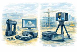
Comparison illustration showing EinScan structured-light scanner on left and FARO LiDAR terrestrial laser scanner on right.

EinScan vs LiDAR Terrestrial Laser Scanners โ€“ Choosing the Right Tool for Reality Capture


The rapid growth of 3D scanning has given engineers, fabricators and designers access to tools that were once limited to large survey companies. Today you can buy a compact EinScan structured-light scanner for a few thousand dollars or hire a FARO or Leica terrestrial LiDAR scanner capable of mapping an entire processing plant in an afternoon. Both are called โ€œ3D scanners,โ€ yet they serve very different purposes. Understanding the difference between EinScan-style scanners and terrestrial LiDAR systems is essential before investing time or money into reality capture.

Two Technologies, Two Different Jobs

EinScan scanners, produced by SHINING 3D, are primarily structured-light or short-range laser scanners. They project patterns of light onto an object and use cameras to interpret how that light deforms across the surface. The result is a dense mesh model of the objectโ€”typically exported as STL, OBJ or PLY files. EinScan units are designed for objects you can walk around, such as mechanical parts, castings, plastic housings and small assemblies.

Terrestrial LiDAR scanners such as the FARO Focus, Leica RTC360 or Trimble X-series operate on a completely different principle. These instruments sit on a tripod and fire millions of laser pulses across a 360-degree field, measuring the time it takes for each pulse to return. The output is a georeferenced point cloud containing precise XYZ coordinates for everything the laser can seeโ€”buildings, structures, conveyors, tanks, pipework and terrain.

Calling both devices โ€œ3D scannersโ€ is like calling a vernier caliper and a total station the same tool. They both measure, but at entirely different scales.
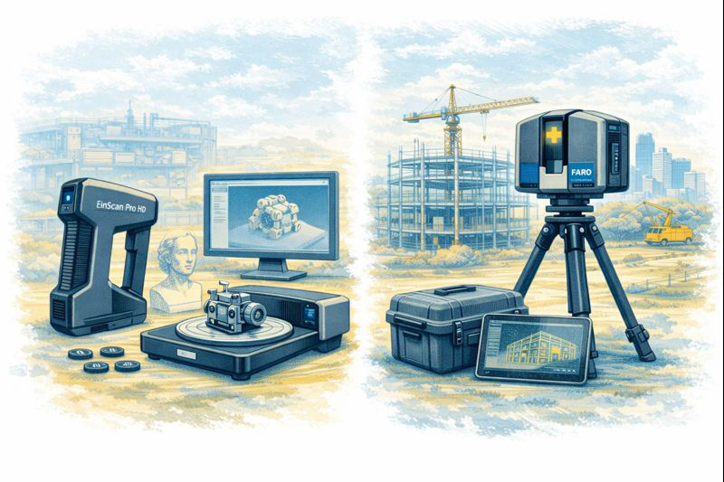

Visual comparison of EinScan object scanner and LiDAR terrestrial laser scanner in matching sketch style.

Scale and Range

The first and most obvious difference is working range.
An EinScan handheld unit is comfortable scanning parts from a few centimetres up to perhaps three or four metres. It is ideal for a gearbox housing on a bench or the plastic bumper of a vehicle. Once the object grows larger than a small room, the scanner begins to lose tracking and accuracy.

A terrestrial LiDAR scanner is built for the opposite end of the spectrum. A FARO Focus S-series can capture data from 0.6 metres out to 70 metres or more, mapping entire buildings or industrial sites from a single setup. Multiple scans are then registered together to create a complete digital twin of a facility.

For workshops and machine shops the question becomes simple:
Are you scanning an object, or are you scanning a place?
Objects suit EinScan; places suit LiDAR.

Accuracy and Tolerance Expectations

Manufacturers often quote impressive numbers, but real-world accuracy must be considered.

  • EinScan desktop and handheld systems typically achieve 0.05โ€“0.2 mm accuracy on small parts when conditions are ideal.
  • Terrestrial LiDAR scanners deliver around ยฑ1 mm to ยฑ3 mm accuracy over distance.

At first glance EinScan appears โ€œmore accurate,โ€ but this is only true at short range. A LiDAR scanner maintains consistent accuracy across tens of metres, something structured-light devices simply cannot do.

For precision mechanical componentsโ€”bearing fits, machined bores, threaded holesโ€”neither technology replaces traditional metrology tools. Scanning excels at capturing shape and context, while micrometers and CMMs remain the authority for tolerance verification.

Type of Data Produced

EinScan produces mesh files made from millions of tiny triangles. These are excellent for visualisation and 3D printing but contain no intelligence about holes, planes or cylinders. CAD systems like SolidWorks or Fusion 360 cannot directly convert these meshes into editable parametric models without additional reverse-engineering work.

LiDAR scanners generate point cloudsโ€”individual points with coordinates and often colour values. Point clouds are perfect for surveying, clash detection, volume calculations and as-built documentation. They are not intended to be edited like CAD models; instead, engineers build new geometry over the top using the cloud as reference.

Understanding this distinction avoids disappointment. Neither scanner delivers a โ€œone-click CAD model.โ€ Human engineering judgement is always required.

Surface and Environmental Limitations

EinScan technology relies on optical cameras and projected light, which introduces several practical limitations:

  • Shiny or black surfaces are difficult to capture
  • Transparent plastics confuse the cameras
  • Deep holes and narrow slots are often missed
  • Sunlight can overpower the projected pattern
  • Tracking can be lost on large flat surfaces

LiDAR systems are more tolerant of environment. They can operate outdoors, in dusty workshops and over long distances. However, they also struggle with highly reflective materials such as polished stainless steel or glass, and they require careful setup to avoid shadows and occlusions.

Workflow Considerations

A typical EinScan workflow looks like this:

  1. Prepare the partโ€”often with scanning spray
  2. Capture multiple passes
  3. Clean and align the mesh
  4. Export STL/OBJ
  5. Rebuild geometry in CAD using the mesh as reference

This process suits reverse engineering of brackets, castings, vehicle parts and consumer products.

A LiDAR workflow is different:

  1. Set up the scanner at multiple locations
  2. Register scans together in software such as FARO Scene or Leica Cyclone
  3. Classify and clean the point cloud
  4. Use the cloud for measurements, modelling or BIM integration

This approach is ideal for as-built surveys, plant upgrades, brownfield design and digital twins.

Cost and Ownership

EinScan systems range from a few thousand to around twenty thousand dollars. They are accessible to small businesses and even serious hobbyists. Software is generally included, and the learning curve is manageable.

Terrestrial LiDAR scanners are capital equipment. Purchase prices often exceed $60,000โ€“$100,000 before software, training and maintenance. For many companies it makes more sense to engage a specialist scanning provider when required.

Hamilton By Design logo displayed on a blue tilted rectangle with a grey gradient background

Choosing the Right Tool

The decision should be driven by the problem you are solving:

Choose EinScan when you need to:

  • Create a bracket to fit an existing motor
  • Reverse engineer a plastic enclosure
  • Modify a vehicle component
  • Capture complex organic shapes
  • Produce meshes for 3D printing

Choose LiDAR when you need to:

  • Document an industrial facility
  • Design around existing plant and pipework
  • Perform clash detection for upgrades
  • Measure volumes and clearances
  • Create a site-wide digital twin

Many organisations ultimately use both. A LiDAR scan provides the big picture, while an EinScan captures detailed components within that environment.
3D LiDAR scanning and 3D modelling service button โ€” laser scanner capturing a point cloud for engineering and CAD modelling
Mechanical engineering services

Integration with CAD

Engineers often ask which scanner works best with SolidWorks or Fusion 360. The honest answer is that neither integrates directly into parametric CAD without intermediate steps. EinScan meshes require reverse-engineering tools or manual modelling. LiDAR point clouds usually pass through Autodesk Recap, FARO Scene or similar before being referenced in CAD.

Scanning is a method of collecting truth, not generating finished design. The value lies in reducing site visits, avoiding clashes and giving designers confidence about existing conditions.

Final Thoughts

EinScan scanners and terrestrial LiDAR systems are not competitors; they are complementary tools on the reality-capture spectrum. One excels at objects on a bench, the other at assets spread across hectares. Selecting the wrong tool leads to frustration, while choosing correctly can transform the way projects are delivered.

For Australian fabricators and engineers, the key question is simple:
Are you capturing a part, or are you capturing a place?
Answer that, and the choice between EinScan and LiDAR becomes clear.
Name
Would you like us to arrange a phone consultation for you?
Address

3D CAD Modelling Australia service banner for Hamilton By Design
Mining & Processing Perth WA banner for Hamilton By Design featuring white text on a blue background.
Scan to BIM Perth WA banner for Hamilton By Design featuring white text on a blue background.
Ship Building Perth WA banner for Hamilton By Design featuring white text on a blue background.
Structural drafting services button
3D LiDAR scanning and 3D modelling services button
Mechanical drafting services button
3D CAD Modelling Australia service banner for Hamilton By Design
3D LiDAR scanning and 3D modelling service button โ€” laser scanner capturing a point cloud for engineering and CAD modelling
Mechanical engineering services
3D CAD Modelling Australia service banner for Hamilton By Design
Mechanical, Structural & Pipework Drafting service banner by Hamilton By Design featuring white text on a blue background.
Australian Drafting logo featuring bold white text reading "Australian Drafting" centred on a blue rounded rectangle background.
Blue banner graphic displaying the text "Point Cloud to CAD - Australia" in large white lettering, representing point cloud processing, scan-to-CAD conversion and digital engineering services across Australia.
CHPP Engineering title graphic featuring bold white text reading "CHPP Engineering" centred on a blue rounded rectangle background.
Engineering Governance title graphic featuring bold white text reading "Engineering Governance" centred on a blue rounded rectangle background.
Mechanical engineering services
Australian Drafting logo featuring bold white text reading "Australian Drafting" centred on a blue rounded rectangle background.
https://www.hamiltonbydesign.com.au/lidar-scanning-brisbane-2
3D LiDAR Scanning Hunter & Newcastle banner with white text on a blue background promoting engineering-grade laser scanning services for industrial, mining and infrastructure projects across the Hunter Valley and Newcastle region.
Mechanical Engineering Hunter & Newcastle banner promoting mechanical engineering services for mining, industrial plants, power generation, manufacturing and heavy industry throughout the Hunter Valley and Newcastle region.
Structural Drafting Hunter & Newcastle banner promoting structural drafting services for mining, industrial plants, power generation, manufacturing and infrastructure projects across the Hunter Valley and Newcastle region.
Mechanical Engineering Perth WA banner for Hamilton By Design featuring white text on a blue background.
3D Laser Scanning Perth WA banner for Hamilton By Design with white text on a blue background.
SolidWorks Perth WA banner for Hamilton By Design featuring white text on a blue background.
Fabrication and product design services
Finite Element Analysis (FEA) engineering simulation button
3D LiDAR scanning and 3D modelling service button โ€” laser scanner capturing a point cloud for engineering and CAD modelling
Blue rounded button with the text โ€œSolidWorks Designโ€ in white.
Mechanical drafting services button
Structural drafting services button

Mechanical Engineering | Structural Engineering


3D Laser Scanning Northern Territory

Getting Engineering Geometry Right for Remote & Regional Projects

Across the Northern Territory, engineering projects operate under a very different set of constraints to those in metropolitan Australia. Vast distances, limited local fabrication capability, extreme environmental conditions and complex logistics mean that engineering accuracy is critical from the outset.

Hamilton By Design provides engineering-led 3D laser scanning services across the Northern Territory, supporting regional and remote projects where fabricated steel and mechanical components must often travel long distances before installation. In these conditions, the cost of getting the geometry wrong is significantly higher.
This page builds on our Darwin-focused scanning services, expanding the discussion to regional NT projects and explaining why laser scanning is essential when distance, logistics and fabrication risk are key drivers.

Engineering in the Northern Territory โ€“ Why Accuracy Is Non-Negotiable

Northern Territory projects frequently involve:

  • Remote or semi-remote sites
  • Limited access to specialist fabrication and trades
  • Long lead times for materials and equipment
  • High transport and mobilisation costs
  • Restricted shutdown or installation windows

In many NT projects, steelwork and mechanical assemblies are designed in one location, fabricated interstate, and transported hundreds or thousands of kilometres to site. Once components are in transit, design errors become extremely expensive to resolve.

This is why Hamilton By Design advocates for engineering-grade 3D laser scanning as the foundation for design and fabrication in the NT.


How This Page Fits with Our Darwin Scanning Services

This Northern Territory page complements our location-specific Darwin services:

  • 3D Scanning Darwin โ€“ focused on project types within Darwin and surrounding areas
  • Darwin LiDAR & Laser Scanning Services โ€“ focused on LiDAR technology and its advantages over traditional measurement

Together, these pages form a connected service offering:

  • Darwin-based projects
  • Regional and remote NT projects
  • Engineering-led scanning for fabrication-critical outcomes

By linking these services, clients can clearly see how scanning scales from urban Darwin projects to remote NT operations.


Why Geometry Matters More on Regional NT Projects

In metropolitan environments, incorrect geometry may result in:

  • A site revisit
  • Minor fabrication changes
  • Manageable delays

In the Northern Territory, the same issue can cause:

  • Fabricated steel arriving on site and not fitting
  • Extended shutdowns while solutions are found
  • Costly re-fabrication or scrapping of components
  • Emergency freight or remobilisation of contractors
  • Significant program delays

Laser scanning reduces these risks by ensuring that design and fabrication are based on verified, real-world geometry, not assumptions or incomplete measurements.


Engineering-Grade 3D Laser Scanning Explained

3D laser scanning uses terrestrial LiDAR to capture millions of spatial data points, creating an accurate digital representation of existing conditions.

Hamilton By Designโ€™s approach is engineering-led, meaning:

  • Scan scope is defined by mechanical and structural requirements
  • Interfaces, tolerances and critical geometry are prioritised
  • Data density supports modelling, detailing and fabrication

This ensures scanning data flows directly into scan-to-CAD, engineering design and fabrication documentation, rather than being a standalone visual output.


Regional Northern Territory Projects That Benefit From Laser Scanning

Mining & Mineral Processing Facilities

Mining operations across the NT often involve plant that has evolved through multiple upgrades.

Laser scanning supports:

  • Conveyor and chute upgrades
  • Crushing and screening plant modifications
  • Structural strengthening and fatigue mitigation

Accurate geometry allows fabrication drawings to be produced confidently, even where legacy drawings no longer reflect reality.


Ports, Marine & Export Infrastructure

Regional ports and export facilities operate in corrosive, high-load environments.

Laser scanning captures:

  • Deformed or corroded steelwork
  • Misalignment from settlement or loading
  • Complex interfaces between old and new structures

This ensures fabricated steel components fit correctly when delivered to site.


Oil, Gas & Energy Infrastructure

Energy projects often rely on prefabrication to minimise shutdown time.

Laser scanning enables:

  • Accurate pipework tie-ins
  • Modular skid installation
  • Structural verification prior to fabrication

This directly supports the Darwin LiDAR & Laser Scanning Services approach by extending it to regional energy assets.


Defence & Government Infrastructure

Defence and government assets across the NT often involve ageing buildings and undocumented modifications.

Laser scanning reduces:

  • Site access requirements
  • Rework during installation
  • Coordination issues between disciplines

This builds on the 3D Scanning Darwin service offering by supporting secure and regional assets.


Water, Sewer & Utilities Infrastructure

Utilities infrastructure must remain operational and reliable.

Laser scanning supports:

  • Pump station upgrades
  • Treatment plant modifications
  • Pipework routing in congested environments

Accurate geometry reduces excavation risk and improves installation certainty.


Fabrication Distance Changes the Risk Profile

In the Northern Territory, fabrication commonly occurs:

  • Interstate
  • In major capital cities
  • At specialist workshops far from site

Once components are fabricated and shipped:

  • Changes are slow and expensive
  • On-site fixes are limited
  • Schedules are exposed

Laser scanning reduces this risk by ensuring fabrication drawings are based on precise, verified geometry, giving confidence that components will fit on arrival.


Laser Scanning vs Traditional Measurement in the NT

AspectTraditional Measurement3D Laser Scanning
Data coverageSelectiveComprehensive
Ability to re-measure remotelyNoYes
Suitability for prefabricationLimitedExcellent
Risk of fabrication errorHighSignificantly reduced
Site revisits requiredFrequentMinimized
Cost impact of errorsSevereControlled

In remote NT projects, the margin for error is simply too small to rely on traditional methods alone.


Engineer-Led Scanning โ€“ A Key Differentiator

Hamilton By Designโ€™s scanning services are delivered by engineers who understand:

  • Fabrication tolerances
  • Structural behaviour
  • Installation sequencing
  • Construction realities

This ensures scanning data integrates seamlessly with:


From Northern Territory Scan to Fabrication-Ready Delivery

Typical NT projects progress from:

  1. On-site 3D laser scanning
  2. Registered point clouds
  3. Engineering-aligned 3D models
  4. Fabrication-ready drawings
  5. Installation-ready outcomes

This workflow supports fit-first-time fabrication, even when components must travel long distances to site.


3D Laser Scanning Northern Territory โ€“ Designed for Distance & Risk

In regional and remote NT projects, geometry errors do not remain isolated โ€” they cascade through fabrication, transport and installation.

By linking Darwin-based scanning services with Northern Territory-wide laser scanning, Hamilton By Design provides a scalable, engineering-focused solution that reduces risk where it matters most.

When steel and mechanical components need to travel long distances, accurate geometry is not optional โ€” it is the foundation of project success.

Hamilton By Design logo displayed on a blue tilted rectangle with a grey gradient background
3D LiDAR scanning and 3D modelling service button โ€” laser scanner capturing a point cloud for engineering and CAD modelling
Mechanical engineering services

Our clients:

Name
Would you like us to arrange a phone consultation for you?
Address

3D Scanning Engineering in Mount Gambier

3D Scanning in Mount Gambier

Mount Gambier is one of South Australiaโ€™s most geologically and environmentally distinctive engineering locations. Built on volcanic ground and surrounded by limestone karst systems and abundant groundwater, it is also the heart of the Limestone Coast forestry and timber-processing industry. Engineering in Mount Gambier must carefully balance ground conditions, water sensitivity, and heavy industrial operations.

Hamilton By Design supports projects across Mount Gambier and the wider Limestone Coast with 3D LiDAR laser scanning, engineering, 3D modelling, FEA, and easy-to-build fabrication drawings, helping clients plan, upgrade, and maintain assets with confidence.


Engineering in Mount Gambier: Where Ground and Water Matter

Unlike many regional centres, engineering in Mount Gambier is heavily influenced by what lies beneath the surface.

Projects here often involve:

  • Volcanic soils and variable ground conditions
  • Limestone bedrock with potential voids and groundwater interaction
  • Forestry, timber processing, and associated heavy plant
  • Industrial facilities operating close to environmentally sensitive areas

These factors make accurate site data and conservative, well-verified engineering essential.


3D Laser Scanning for Mount Gambier Projects

High-accuracy 3D LiDAR laser scanning provides a reliable foundation for engineering in Mount Gambier.

Hamilton By Design captures precise as-built data for:

  • Sawmills and timber-processing facilities
  • Conveyors, handling systems, and heavy machinery
  • Industrial buildings, platforms, and access structures
  • Infrastructure located on variable or sensitive ground

3D scanning records the true geometry of existing assets, including misalignment, settlement, and undocumented modifications โ€” all common in older industrial sites and facilities built over complex geology.

This allows projects to move forward with reduced risk, fewer site visits, and greater confidence during construction.

Learn more about our scanning services:
3D Laser Scanning


3D Modelling Built from Real As-Built Conditions

From the point cloud, Hamilton By Design develops accurate 3D CAD models that reflect actual site conditions.

Our 3D modelling services support:

  • Brownfield plant upgrades
  • Modifications to timber-processing equipment
  • Spatial coordination in tight industrial layouts
  • Clash detection and constructability reviews
  • Long-term digital asset records

In Mount Gambier, modelling from real data is especially valuable where ground movement, legacy plant, or limited documentation exists.

Explore our modelling capability:
3D CAD Modelling


FEA for Structural and Mechanical Confidence

Many Mount Gambier assets operate continuously and must perform reliably under changing loads and environmental conditions. Finite Element Analysis (FEA) is used to validate designs and extend asset life.

Hamilton By Design applies FEA to:

  • Assess structural capacity and stiffness
  • Check modifications to existing steelwork
  • Evaluate deflection, fatigue, and buckling
  • Support strengthening or life-extension decisions

By analysing as-built geometry, FEA provides results that better represent real behaviour โ€” particularly important where foundations and ground conditions influence structural performance.

Learn more about our analysis services:
FEA Capabilities


Easy-to-Build Fabrication and Installation Drawings

Clear, practical documentation is essential for regional projects where fabrication and installation teams rely on drawings to get the job done efficiently.

Hamilton By Design produces easy-to-build fabrication drawings, including:

  • General arrangement drawings
  • Fabrication and workshop details
  • Installation and modification layouts
  • As-built documentation

Because drawings are generated directly from scanned data and validated 3D models, they align closely with site conditions, reducing ambiguity and rework.

View our drafting services:
Drafting Services


Hamilton By Design logo displayed on a blue tilted rectangle with a grey gradient background
3D LiDAR scanning and 3D modelling service button โ€” laser scanner capturing a point cloud for engineering and CAD modelling
Mechanical engineering services

Why Hamilton By Design in Mount Gambier?

Hamilton By Design delivers an integrated, engineering-led workflow โ€” from site capture through to modelling, analysis, and construction documentation.

For Mount Gambier clients, this means:

  • Better understanding of complex ground and plant conditions
  • Reduced risk when upgrading existing assets
  • Designs that support forestry and industrial operations
  • Fabrication-ready drawings that are practical to build

Whether you are working within timber processing, industrial facilities, or regional infrastructure, Hamilton By Design provides accurate, practical, and build-ready engineering solutions tailored to Mount Gambierโ€™s unique conditions.

If youโ€™re planning a project in Mount Gambier or across the Limestone Coast, weโ€™re ready to help โ€” starting with accurate data and carrying it through to buildable outcomes.

Our clients

Name
Would you like us to arrange a phone consultation for you?
Address
Finite Element Analysis (FEA) engineering simulation button
Mechanical engineering services
3D LiDAR scanning and 3D modelling service button โ€” laser scanner capturing a point cloud for engineering and CAD modelling
Mechanical engineering services


Finite Element Analysis (FEA) engineering simulation button
Mechanical engineering services


3D CAD Modelling Australia service banner for Hamilton By Design


CHPP Engineering title graphic featuring bold white text reading "CHPP Engineering" centred on a blue rounded rectangle background.
Pipework Drafting title graphic featuring bold white text reading "Pipework Drafting" centred on a blue rounded rectangle background.
3D LiDAR Scanning for Engineering Projects title graphic featuring bold white text on a blue rounded rectangle background.


Finite Element Analysis (FEA) engineering simulation button
Structural drafting services button
Mechanical drafting services button


Australian Drafting logo featuring bold white text reading "Australian Drafting" centred on a blue rounded rectangle background.
Engineering Governance title graphic featuring bold white text reading "Engineering Governance" centred on a blue rounded rectangle background.
Engineering-Grade LiDAR Scanning title graphic featuring bold white text on a blue rounded rectangle background.