Why Scanner Stability Matters When Accuracy Matters
LiDAR stands for Light Detection and Ranging. It uses laser light to measure distance and create a 3D digital representation of the real world.
But in engineering, the distance measurement is only part of the story.
To produce reliable design, drafting and fabrication data, the scanner also needs to know exactly where it was positioned, how it was orientated, and how every measurement relates to the rest of the site.
That is why stable, engineering-grade scanning matters.
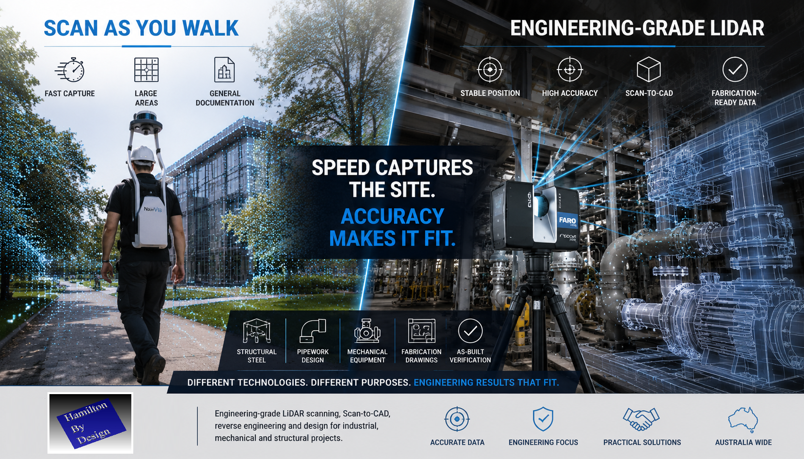
Scan as You Walk Has Its Place
Walk-through LiDAR systems such as NavVis-style mobile scanners are impressive technologies. They allow an operator to move through an environment while capturing large volumes of spatial data quickly.
For some applications, this is a major advantage.
Scan-as-you-walk systems can be useful for:
- Facility documentation
- Asset walkthroughs
- Digital tours
- Large building capture
- Universities
- Shopping centres
- Hospitals
- National parks
- General spatial records
If the objective is to document a large area quickly, mobile scanning can be a practical solution.
But speed is not the same as engineering certainty.
Engineering Accuracy Requires More Than Walking Through a Site
When a scanner is moving, the system must continuously calculate:
- where the scanner is located
- which direction it is facing
- how fast it is moving
- how it is rotating
- how each scan position connects to the next
This is normally achieved using SLAM, cameras, IMUs and software-based positioning.
These systems are powerful, but they can still be affected by drift, movement, poor geometry, reflective surfaces, repetitive structures and weak reference points.
In engineering, small errors can become expensive problems.
A point cloud may look good on screen, but that does not always mean it is suitable for mechanical design, structural detailing or fabrication.
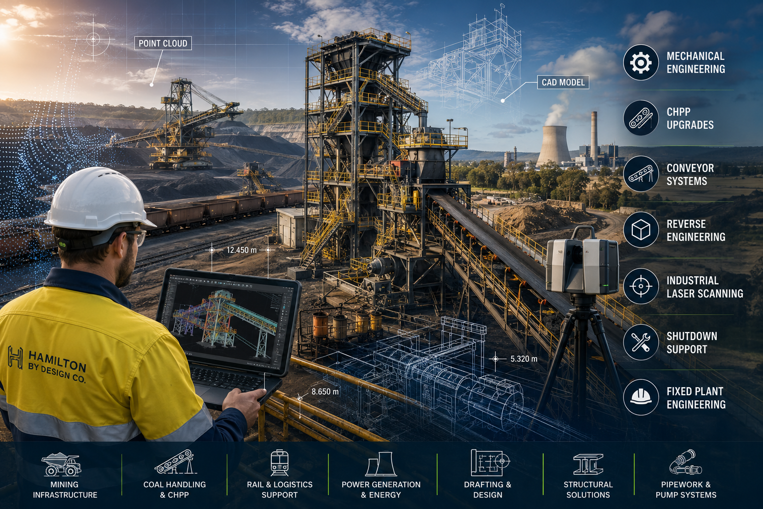
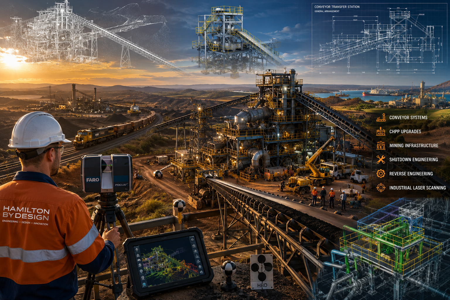
Why Hamilton By Design Uses FARO Focus Technology
At Hamilton By Design, we use FARO Focus terrestrial laser scanning for engineering-grade reality capture.
The FARO Focus scanner is set up on a stable tripod position. It captures high-density scan data from fixed locations, allowing the point cloud to be registered, checked and used for design work with confidence.
This approach is slower than simply walking through a site, but it provides the quality of data required for engineering deliverables.
We use FARO scanning for:
- Scan-to-CAD
- Reverse engineering
- Mechanical design
- Structural steel modelling
- Pipework layouts
- Fabrication drawings
- As-built documentation
- Clash detection
- Plant room scanning
- Industrial site verification
- Shutdown planning
When structural steel needs to fit, pipework needs to align and fabricated components need to be manufactured from the captured data, accuracy matters.
The Difference Is the Final Outcome
A walk-through scan may be suitable when the purpose is general documentation.
A FARO Focus scan is more suitable when the data will be used to design, manufacture, install or verify engineered components.
That difference matters.
If the objective is to walk through a national park, a mobile scanner may be the right tool.
If the objective is to make sure structural beams, pipe spools, platforms, chutes, hoppers or mechanical components fit together correctly, then engineering-grade LiDAR scanning is the safer choice.
Because when the fabrication team arrives on site, the steel either fits or it does not.
Real-World Engineering Experience
Hamilton By Design is often asked to revisit sites where previous scan data was not suitable for engineering use.
In recent weeks, we have been requested multiple times to rescan building and industrial sites after earlier walk-through scanning did not provide the level of accuracy or detail required for design and drafting.
This does not mean mobile scanning is wrong.
It means the scanning method must match the intended use.
For general site capture, speed may be the priority.
For engineering, fabrication and installation, accuracy must come first.
LiDAR Measures Distance. Engineering Requires Position Certainty.
LiDAR uses light to measure distance.
However, engineering-grade point clouds require more than distance. They require confidence in the scanner position, orientation, registration and final geometry.
A simple way to explain it is this:
A tape measure may be accurate, but if you do not know exactly where the measurement started, the result can still be wrong.
The same applies to LiDAR scanning.
The laser may measure accurately, but if the scanner position is uncertain, the final point cloud may not be suitable for engineering work.
Where FARO Focus Scanning Adds Value
Hamilton By Design provides engineering-led LiDAR scanning for clients who need usable design data, not just a visual point cloud.
Our scanning and modelling services support:
- Industrial plants
- Mechanical rooms
- Processing facilities
- Mining infrastructure
- Conveyor systems
- Structural platforms
- Pipework and services
- Equipment layouts
- Existing buildings
- Brownfield modification projects
We do not just scan the site.
We understand how the scan data will be used in design, drafting, fabrication and installation.
That engineering understanding is what makes the difference.
Engineering-Grade Deliverables
Depending on the project requirements, Hamilton By Design can provide:
- Registered point clouds
- E57 files
- RCP / RCS files
- Scan-to-CAD models
- AutoCAD drawings
- SolidWorks models
- Inventor models
- STEP / SAT / Parasolid files
- General arrangement drawings
- Sections and elevations
- Fabrication drawings
- As-built verification models
Our focus is to provide practical engineering information that can be used by designers, fabricators, builders, installers and asset owners.
Choose the Right Scanner for the Right Job
Scan-as-you-walk systems are fast and useful for many documentation tasks.
FARO Focus scanning is better suited to engineering-grade work where accuracy, registration and point cloud quality are critical.
At Hamilton By Design, we believe the technology should be selected based on the outcome required.
If you need to document a large space quickly, mobile scanning may be suitable.
If you need structural steel, pipework or mechanical components to fit together first time, FARO Focus scanning is hard to go past.
Hamilton By Design – Engineering-Led LiDAR Scanning
Hamilton By Design provides engineering-grade LiDAR scanning, Scan-to-CAD, reverse engineering, mechanical drafting and structural design support across Australia.
We combine reality capture with practical engineering experience to help clients move from existing site conditions to accurate design and fabrication deliverables.
For industrial, mechanical and structural projects, the question is not just how fast the site can be scanned.
The real question is:
Can the scan data be trusted when it is time to design, fabricate and install?
That is where engineering-grade LiDAR scanning matters.


Would you like to know more ?
Contact Us – Talk to Us
Our Clients