


Terrestrial vs LiDAR Scanners | What’s the Difference?
Confusion around terrestrial scanning and LiDAR scanning is common — and understandable.
The two terms are often used interchangeably, even though they describe different things.
This page explains the difference in plain language, shows where each approach fits, and helps you decide what level of accuracy and risk is appropriate for your project.
Short Answer (If You’re in a Hurry)
LiDAR describes the laser measurement technology.
Terrestrial describes how and where that LiDAR scanner is deployed.
Most terrestrial scanners use LiDAR, but not all LiDAR scanners are terrestrial.
What Is LiDAR?
LiDAR (Light Detection and Ranging) is a method of measuring distance using laser light.
How LiDAR works
- A laser pulse is emitted
- The pulse reflects off an object
- The return time is measured
- Distance is calculated and stored as a 3D point
Millions of these points form a point cloud that represents real-world geometry.
What LiDAR is good for
- Accurate 3D measurement
- Complex geometry
- Low-light or enclosed environments
- Engineering, construction, and industrial sites
LiDAR answers: How is distance measured?
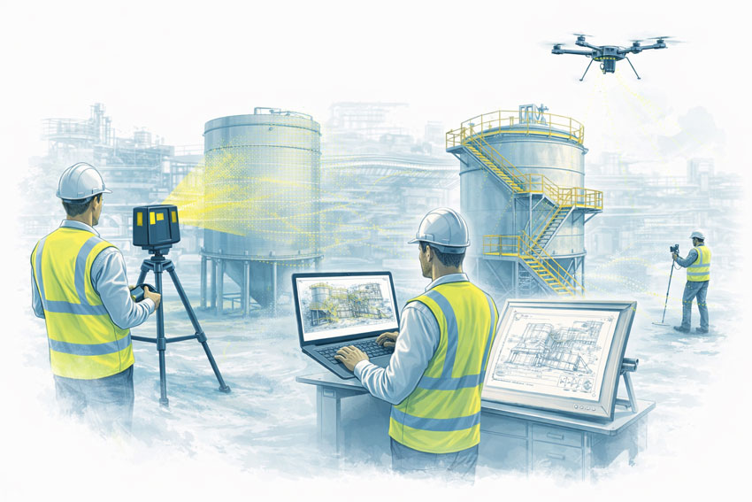
What Is a Terrestrial Scanner?
A terrestrial scanner is a ground-based scanning system, usually mounted on a tripod or fixed position.
Key characteristics
- Fixed scan position
- Controlled setup and coverage
- Known geometry and reference
- High repeatability and validation
Typical environments
- Processing plants and CHPPs
- Structural steelwork
- Conveyor systems
- Brownfield tie-ins
- As-built verification
- Shutdown-critical fit-up work
Terrestrial answers: Where and how is the LiDAR deployed?
How the Two Terms Relate (This Is the Important Part)
A terrestrial scanner is a platform.
A LiDAR scanner is a technology.
Most modern terrestrial scanners are terrestrial LiDAR scanners.
Example: a tripod-mounted system such as the FARO Focus S-Series is:
- LiDAR-based (laser measurement)
- Terrestrial (ground-based, fixed setup)
Other Common LiDAR Scanner Types (And Why It Matters)
| Scanner Type | How It’s Used | Typical Outcome |
|---|---|---|
| Terrestrial LiDAR | Tripod / fixed | Highest control & accuracy |
| Mobile / SLAM LiDAR | Handheld / walk-through | Fast capture, lower control |
| Vehicle-mounted LiDAR | Car / trolley | Corridor mapping |
| Aerial LiDAR | Drone / aircraft | Large areas, low detail |
All are “LiDAR”, but not all are suitable for engineering design or fabrication.
Why This Distinction Matters for Projects
Many issues occur when:
- A LiDAR scan is assumed to be engineering-grade
- A mobile or SLAM scan is used beyond its intent
- Accuracy, validation, or limitations are not clearly understood
This doesn’t mean one method is wrong — it means each has a purpose.
The key is aligning the scanner type with:
- Required accuracy
- Risk tolerance
- Fit-up criticality
- Intended use of the data
Our clients:


Simple Decision Guide (Client in Control)
If you need:
- Fabrication or replacement parts → Terrestrial LiDAR
- Shutdown-critical fit-up → Terrestrial LiDAR
- Structural verification → Terrestrial LiDAR
- Rapid site context only → Mobile / SLAM LiDAR
- Large terrain or stockpiles → Aerial LiDAR
There is no “one best scanner” — only the right scanner for the outcome you want.
Comparison at a Glance
| Requirement | Terrestrial LiDAR | Mobile / SLAM LiDAR |
|---|---|---|
| Accuracy control | High | Moderate |
| Repeatability | High | Lower |
| Engineering defensibility | Strong | Limited |
| Fit-up confidence | Suitable | Not recommended |
| Capture speed | Slower | Faster |
| Best use case | Design & fabrication | Visualisation & context |
A Note on Engineering Use
Where scanning data feeds into engineering design, documentation, or fabrication, higher-control methods are typically required to align with engineering practice and Australian Standards expectations.
That doesn’t remove choice — it simply means the assumptions and limitations must match the intended use.
How We Approach This (Without Locking You In)
We’re happy to:
- Work with terrestrial, mobile, or supplied scan data
- Validate data before design where required
- Align scanning effort with your risk, budget, and outcome
- Clearly document assumptions and limitations
You stay in control of the approach — our role is to make sure the data supports the outcome you expect.

Next Step
If you’re unsure which scanning method suits your project:
Fill out the contact form and tell us:
- What you want to build, replace, or verify
- How the data will be used
- Any constraints (budget, time, shutdown windows)
We’ll help you select a fit-for-purpose scanning approach, not just a scanner.