

Port Macquarie Manufacturing & Industrial Engineering
Engineering Solutions for Manufacturers, Fabricators & Industrial Facilities Across the Mid North Coast
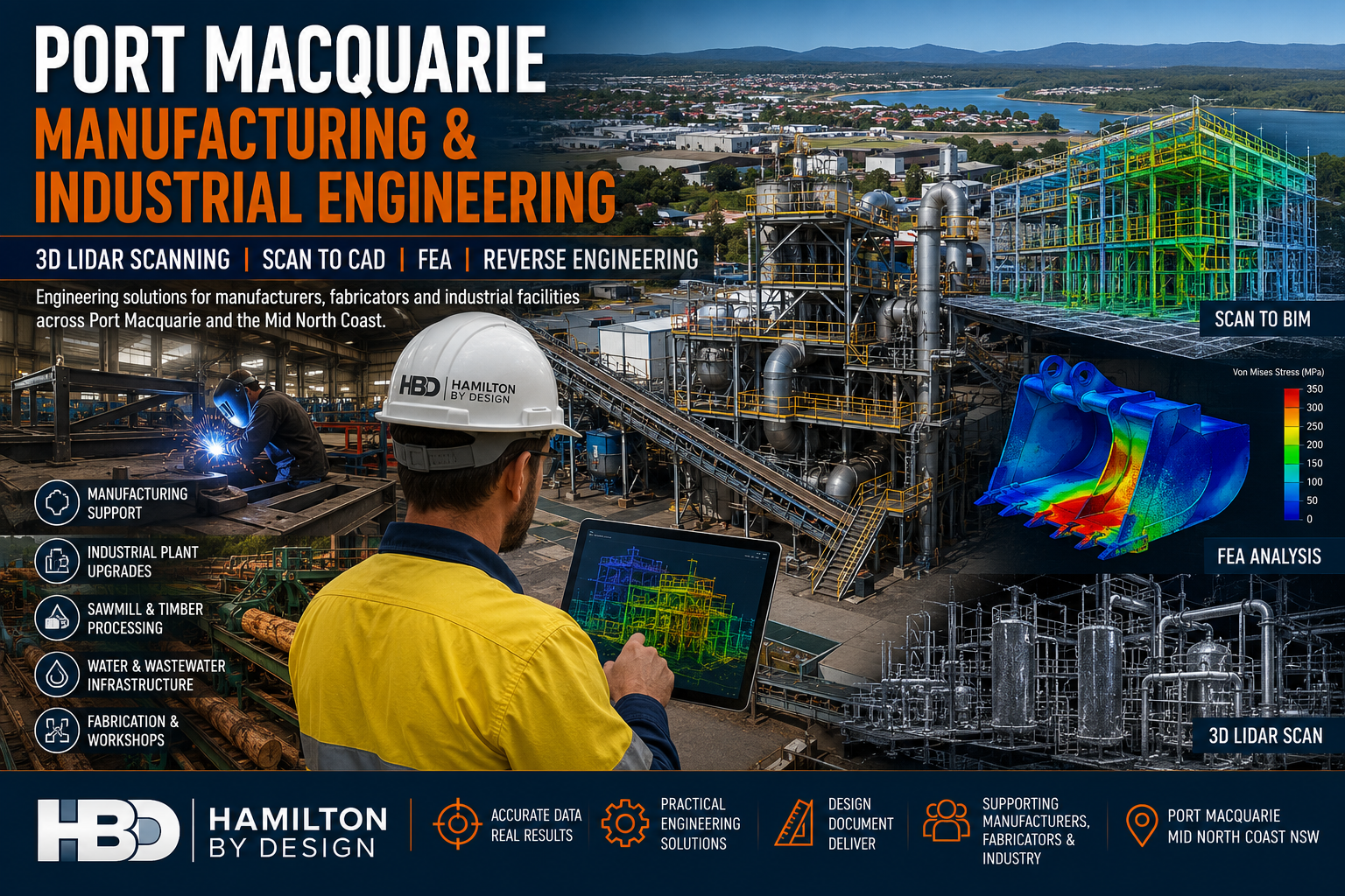
Hamilton By Design provides engineering-led mechanical engineering, 3D LiDAR scanning, Scan to CAD, Scan to BIM, reverse engineering, finite element analysis (FEA) and engineering drafting services throughout Port Macquarie, Wauchope, Kempsey, Southwest Rocks, Laurieton and the wider Mid North Coast region.
The Port Macquarie region is home to a growing manufacturing and industrial sector that supports timber processing, food manufacturing, fabrication workshops, transport operators, water infrastructure, marine industries and industrial processing facilities.
As facilities grow and equipment ages, accurate engineering information becomes critical for maintaining productivity, reducing downtime and planning future upgrades.
Hamilton By Design helps manufacturers, engineers, fabricators and asset owners capture existing conditions, develop accurate engineering models and deliver practical solutions for brownfield and greenfield projects.
Whether your project involves upgrading a sawmill, replacing ageing equipment, scanning a processing plant, developing fabrication drawings or validating a design using Finite Element Analysis, our team provides practical engineering support backed by decades of industry experience.
Engineering Services for Manufacturers
Supporting Manufacturing Growth Across Port Macquarie
Manufacturing businesses face increasing pressure to improve productivity, reduce maintenance costs and modernise existing facilities.
Hamilton By Design supports manufacturers by providing:
- Mechanical Engineering
- Equipment Design
- Plant Layout Design
- Reverse Engineering
- Engineering Drafting
- 3D Laser Scanning
- Scan to CAD
- Finite Element Analysis
- Asset Documentation
- Brownfield Upgrade Support
Our engineering services help manufacturers make informed decisions based on accurate site information and engineering data.
Industrial Plant Engineering
Engineering Support for Existing Facilities
Many industrial facilities have evolved over decades through multiple modifications and expansions.
Unfortunately, original drawings often no longer reflect actual site conditions.
Hamilton By Design provides engineering solutions that allow businesses to accurately document and understand their facilities before commencing upgrades or maintenance projects.
Typical facilities include:
- Manufacturing Plants
- Timber Processing Facilities
- Food Processing Facilities
- Water Treatment Plants
- Wastewater Facilities
- Recycling Facilities
- Quarry Operations
- Industrial Workshops
- Processing Plants
3D LiDAR Scanning Port Macquarie
Engineering Grade Reality Capture
Hamilton By Design provides engineering-grade terrestrial laser scanning services that capture millions of highly accurate measurements.
Laser scanning creates an accurate digital representation of existing facilities and equipment, allowing engineering teams to design with confidence.
Applications include:
- Manufacturing Facilities
- Industrial Plants
- Sawmills
- Warehouses
- Water Infrastructure
- Processing Facilities
- Structural Steel
- Pipework Systems
- Mechanical Equipment
Deliverables include:
- E57 Files
- RCP Files
- RCS Files
- LAS Files
- Registered Point Clouds
- Existing Condition Models
- Engineering Drawings
Sawmill & Timber Processing Engineering
Supporting Brownfield Upgrades
The Mid North Coast has a long history of timber processing and sawmill operations.
Many facilities have grown over decades and contain a mixture of original equipment, modifications and undocumented changes.
Hamilton By Design supports sawmill operators with:
- Existing Condition Surveys
- 3D Laser Scanning
- Conveyor Design
- Structural Modifications
- Dust Extraction Upgrades
- Equipment Replacement Projects
- Scan to CAD Services
- Engineering Documentation
Laser scanning enables accurate modelling of existing plant conditions, reducing project risk and improving installation outcomes.
Scan to CAD Services
Converting Reality into Engineering Information
Point cloud data becomes significantly more valuable when converted into usable engineering deliverables.
Hamilton By Design converts laser scan data into:
- AutoCAD Drawings
- Plant Layouts
- General Arrangement Drawings
- Equipment Layout Drawings
- Structural Drawings
- Mechanical Drawings
- Fabrication Drawings
These deliverables assist engineers, fabricators and project teams during design and construction activities.
Scan to BIM Services
Building Information Modelling for Existing Assets
Hamilton By Design develops BIM models from laser scan data to support engineering, construction and asset management projects.
We develop BIM models for:
- Buildings
- Infrastructure
- Industrial Facilities
- Processing Plants
- Utilities
- Manufacturing Facilities
- Water Treatment Facilities
- Government Assets
Benefits include:
- Improved project coordination
- Reduced design clashes
- Improved construction planning
- Better asset management
- Digital Twin Development
- Enhanced lifecycle management
For industrial facilities and manufacturing operations, Scan to BIM provides an accurate digital foundation for future upgrades and expansion projects.
Mechanical Engineering Services
Practical Engineering Solutions
Hamilton By Design provides mechanical engineering services focused on practical, buildable and maintainable outcomes.
Services include:
- Mechanical Design
- Equipment Design
- Conveyor Design
- Chute Design
- Hopper Design
- Materials Handling Systems
- Structural Interfaces
- Equipment Modifications
- Design Reviews
- Shutdown Engineering
Our experience spans manufacturing, mining, industrial processing and infrastructure projects throughout Australia.
Finite Element Analysis (FEA)
Engineering Validation Before Fabrication
Finite Element Analysis allows engineers to assess how components and structures perform under load before manufacturing begins.
Hamilton By Design provides FEA services for:
Loader Buckets
Assessment of:
- Wear zones
- Reinforcement design
- Fatigue performance
- Structural adequacy
Excavator Buckets
Analysis of:
- Impact loading
- Structural integrity
- Wear protection systems
- Load distribution
Grader Blades
Verification of:
- Structural support systems
- Ground engagement loads
- Deflection performance
- Wear areas
Chutes & Hoppers
Evaluation of:
- Material loading
- Structural performance
- Impact zones
- Reinforcement requirements
Industrial Structures
Assessment of:
- Platforms
- Walkways
- Equipment Supports
- Access Systems
- Structural Frames
FEA provides confidence that designs will perform safely and efficiently under operational conditions.
Reverse Engineering Services
Recreating Existing Assets
When original engineering drawings are unavailable, reverse engineering can recover valuable engineering information.
Hamilton By Design provides reverse engineering services for:
- Mechanical Components
- Pumps
- Shafts
- Castings
- Conveyor Components
- Wear Liners
- Structural Components
- Machinery Assemblies
Deliverables include:
- SolidWorks Models
- STEP Files
- SAT Files
- Fabrication Drawings
- Manufacturing Drawings
Engineering Drafting Services
Professional Documentation for Construction & Fabrication
Our drafting services provide accurate engineering documentation for manufacturing, industrial and infrastructure projects.
Services include:
- Mechanical Drafting
- Structural Drafting
- Fabrication Drawings
- Workshop Drawings
- As-Built Drawings
- Construction Documentation
- Plant Layout Drawings
Using:
- SolidWorks
- Autodesk Inventor
- AutoCAD
- Navisworks
- FARO SCENE
- Autodesk ReCap
Why Choose Hamilton By Design?
Engineering-Led Approach
We understand how engineering information is used throughout the project lifecycle.
Practical Industry Experience
Experience supporting:
- Manufacturers
- Fabricators
- Mining Operations
- Industrial Facilities
- Utilities
- Infrastructure Owners
Advanced Technology
Including:
- FARO Focus Laser Scanners
- FARO Orbis Mobile Scanning
- FARO SCENE
- SolidWorks
- ANSYS
- Autodesk Inventor
- AutoCAD
- Navisworks
Australia-Wide Capability
Supporting projects across:
- Port Macquarie
- Mid North Coast
- Newcastle & Hunter
- Sydney
- Brisbane
- Melbourne
- Adelaide
- Perth

Need Engineering Support in Port Macquarie?
Whether your project involves manufacturing facilities, industrial plants, sawmills, water infrastructure or brownfield upgrades, Hamilton By Design provides practical engineering solutions backed by real industry experience.
Our Services
✔ Manufacturing Engineering
✔ Industrial Engineering
✔ Mechanical Engineering
✔ 3D LiDAR Scanning
✔ Scan to CAD
✔ Scan to BIM
✔ Reverse Engineering
✔ Finite Element Analysis (FEA)
✔ Engineering Drafting
✔ Sawmill Engineering Support
✔ Industrial Plant Upgrades
✔ Brownfield Engineering Projects
Talk to Us – Contact Us
Our clients:


