3D Scanner Penrith

3D laser scanner in Penrith capturing industrial facility as point cloud for engineering design

3D Scanner Penrith | Engineering LiDAR Scanning

Engineering-grade LiDAR & laser scanning in Penrith, Western Sydney — capture it once, design it right.

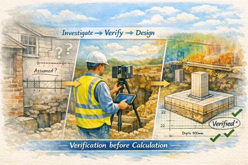
When you’re upgrading a plant, refurbishing a building, or tying new steel into an existing structure, you don’t want “close enough”. You want site truth — fast. Hamilton By Design delivers 3D laser scanning (LiDAR) and point clouds in Penrith and Western Sydney, so your engineers, designers, and fabricators can work from accurate as-built data and reduce rework.

Penrith is in the middle of major growth and infrastructure change across Western Sydney, which makes reliable existing-condition data even more valuable for upgrades and brownfields work.


3D scanner Penrith creating accurate as-built point cloud of factory for upgrades

What “3D scanning” means for your project

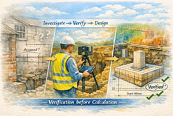
A 3D scanner captures millions of points per second to create a high-density point cloud of your site. That point cloud becomes the backbone of the job:

  • Faster measuring and fewer return site visits
  • Better clash detection and tie-in confidence
  • Cleaner fabrication drawings and install fit-up
  • Reduced variations caused by missing or outdated as-built information

If the initial scan quality is poor, everything downstream gets harder — modelling, detailing, QA checks, and construction coordination all suffer.


3D scanning services in Penrith

We support projects across Penrith, St Marys, Kingswood, Werrington, Emu Plains, Glenmore Park and surrounding industrial/commercial areas.

Typical use cases

  • Structural steel tie-ins & refurbishments (accurate interface points)
  • Industrial sites & plants (brownfields upgrades, shutdown planning)
  • Commercial buildings (facade/elevation capture, services coordination)
  • Mechanical & piping modifications (spools, supports, and retrofit work)
  • Condition capture for tendering (reduce unknowns before you price)

Deliverables that plug into your workflow

We keep deliverables practical and construction-ready, including:

  • Registered point cloud (industry-standard formats)
  • 2D outputs (plans/elevations/sections as required)
  • 3D model support (scan-to-model packages if needed)
  • Interface extraction (critical tie-in set-out points and checks)

(If you tell us what platform your team uses, we’ll align deliverables to suit your workflow.)


How the onsite scan usually runs

  1. Scope & safety planning (access, traffic, operating plant constraints)
  2. Capture (multiple scan positions for full coverage)
  3. Registration & QA (clean, aligned dataset)
  4. Delivery (point cloud + agreed outputs, with notes on any occlusions)

For live environments we can plan around operations, access restrictions, and foot traffic to protect equipment and improve capture outcomes.


Why Hamilton By Design for Penrith scanning

We’re an engineering-led team. That matters because scanning isn’t just “collecting data” — it’s collecting the right data to make design and fabrication easier.

You’ll get:

  • Practical capture strategies that target tie-ins and risk areas
  • Clear communication on what’s captured (and what can’t be seen)
  • Outputs designed to reduce RFIs, assumptions, and rework

Penrith’s ongoing development and precinct planning means brownfields interfaces are common — and accurate as-builts help projects stay predictable.


Get a quote for 3D scanning in Penrith

If you want a fast, accurate capture and a dataset your team can trust:

Call / Email: (add your preferred contact details)
Service area: Penrith + Western Sydney
Turnaround: dependent on site size and deliverables

What to include in your enquiry

  • Site address + access constraints
  • What you’re building / modifying
  • Priority areas (tie-ins, steel interfaces, plant items)
  • Required deliverables and required accuracy (if specified)

Hamilton By Design logo displayed on a blue tilted rectangle with a grey gradient background

FAQ

How accurate is a 3D scan?

Accuracy depends on scanner type, site conditions, scan geometry, and required control. For most engineering upgrades, the goal is fit-for-purpose accuracy around tie-in areas, not just a pretty model.

Can you scan operating sites?

Yes — we plan around operations, safe access, and line-of-sight limitations.

Do you do scan-to-model?

Yes. We can deliver point clouds only, or provide scan-to-model packages depending on your scope and downstream needs.


3D Laser Scanning in New Caledonia – Engineering Certainty in a Remote Environment

Illustration of 3D laser scanning in New Caledonia showing a LiDAR scanner capturing an industrial site over a coloured map with the Kanak flag and point cloud overlay.

3D Laser Scanning New Caledonia | Hamilton By Design

Engineering projects in New Caledonia operate in a unique environment. Nickel processing plants, port facilities, power stations and infrastructure are often decades old, heavily modified and located far from design offices. Accurate site information is the difference between a smooth project and an expensive lesson.

3D laser scanning has become the most reliable way to capture existing conditions across Nouméa, Koné and the remote mine sites of the Grande Terre. Instead of relying on tape measures and assumptions, LiDAR technology records millions of precise measurements to create a true digital twin of the asset.


The Challenge of Brownfields Projects in New Caledonia

Many facilities in New Caledonia share the same constraints:

  • Limited shutdown windows
  • Corrosive coastal environments
  • Historical modifications with poor drawings
  • Logistics that make repeat site visits costly
  • Multi-discipline coordination between local and overseas teams

Traditional survey methods struggle to capture congested pipe racks, structural steel distortions or equipment that has shifted over time. When drawings do not match reality, fabrication delays and site rework quickly follow.


3D laser scanning New Caledonia graphic with national colours, flag on map, industrial facility and workflow from scan to first-time fit.

The Scan Is the Backbone of the Project

The initial scan quality sets the tone for every task that follows. The point cloud becomes the backbone of the project—design, detailing, fabrication and construction all rely on it.

If you start with a broken backbone, you will have problems everywhere else:

  • Simple tasks become difficult
  • Measurements are questioned
  • models need rework
  • fabricators lose confidence
  • schedules start to slip

A clean, well-registered scan makes coordination easy. A poor scan multiplies effort for every member of the team.


Protecting the Whole Project Team

3D laser scanning is not just about creating a model—it is about protecting everyone involved:

  • Project managers who must control time and cost
  • Engineers responsible for safe and compliant designs
  • Designers and draftspersons who need reliable geometry
  • Fabricators who must build components that fit
  • Construction crews who install the work on short shutdowns

When the as-built data is right, the entire chain works with confidence. When it is wrong, every discipline inherits the problem.


How 3D Laser Scanning Changes the Outcome

A terrestrial laser scanner captures a complete point cloud of the site in hours rather than weeks. The data can then be used for:

  • Accurate as-built models for upgrades and expansions
  • Tie-in design for new conveyors, tanks and platforms
  • Structural verification of aging infrastructure
  • Clash detection before fabrication
  • Shutdown planning and risk reduction
  • Asset documentation for long-term maintenance

For New Caledonian projects, the biggest benefit is capture once, design anywhere. Local scanning crews can collect the data while engineering teams in Australia or New Zealand work from the same digital environment without further travel.


Typical Applications Across New Caledonia

Mining & Processing

  • Nickel plant upgrades
  • Conveyor replacements
  • Chute and transfer redesign
  • Tank and thickener modifications
  • Access platforms and walkways

Ports & Infrastructure

  • Wharf structural assessments
  • Ship loader interfaces
  • Pipe bridges and services
  • Electrical and control building upgrades

Energy & Utilities

  • Power station retrofits
  • Water treatment facilities
  • Fuel storage terminals

From Point Cloud to Deliverables

A professional workflow generally includes:

  1. On-site LiDAR capture with survey control
  2. Registration and quality assurance
  3. Creation of usable formats for Revit, AutoCAD, SolidWorks or Navisworks
  4. Extraction of models, drawings or clash reports
  5. Ongoing support during fabrication and installation

The result is engineering data you can trust—without the need for multiple trips to site.


Hamilton By Design logo displayed on a blue tilted rectangle with a grey gradient background

Ready to De-Risk Your Project?

Whether your project is in Nouméa, Koné or a remote mine site, 3D laser scanning provides the foundation for safe, predictable and efficient engineering. Get the backbone right at the start and the rest of the project becomes easier.


Name
Would you like us to arrange a phone consultation for you?
Address

3D Scanning Blue Mountains – Engineering-Grade LiDAR by Hamilton By Design

3D laser scanning workflow in the Blue Mountains showing FARO Focus capture, point cloud and CAD model for fit-first-time construction

Engineering-Grade LiDAR by Hamilton By Design

The Blue Mountains presents some of the most demanding environments for measurement and design in NSW. Steep escarpments, ageing heritage buildings, bushfire-affected properties, and complex tourism infrastructure mean that traditional survey methods are often unsafe, incomplete, or inaccurate.

Hamilton By Design provides engineering-grade 3D laser scanning across the Blue Mountains — delivering precise point clouds and high-resolution imagery that can be used directly for structural design, drafting, approvals, and construction.


Engineering Data You Can Design From

Our workflow is built around the FARO Focus LiDAR platform, capturing millions of points with millimetre accuracy. Unlike basic reality capture, our service is aimed specifically at engineering and fabrication outcomes:

  • Point clouds aligned to project coordinate systems
  • Accuracy suitable for structural steel interfaces
  • High-resolution HDR imagery from the scanner camera
  • Data prepared for SolidWorks, AutoCAD and BIM workflows
  • Outputs ready for drafting and clash detection

This is not marketing visualisation — it is measurement data that engineers can rely on.


Why the Blue Mountains Demands Professional Scanning

Projects in Katoomba, Leura, Wentworth Falls and Springwood share common risks:

  • Original drawings rarely match existing conditions
  • Buildings sit on rock shelves and irregular terrain
  • Access is limited and weather changes quickly
  • Heritage fabric must not be touched
  • Bushfire rebuilds require objective records

In these environments, even small measurement errors lead to major problems during fabrication and installation. Engineering-grade scanning removes that uncertainty by capturing reality first.


What We Scan in the Blue Mountains

Structural & Industrial

  • Platforms and access structures
  • Steel upgrades and extensions
  • Mechanical plant rooms
  • Conveyor and process equipment
  • Bridges and rail infrastructure

Heritage & Tourism

  • Federation cottages and guesthouses
  • Scenic World structures
  • Lookouts and stone pathways
  • Churches and community buildings

Residential & Bushfire Rebuilds

  • Split-level homes on escarpments
  • Retaining walls and rock faces
  • Pre-loss insurance documentation
  • Extensions with no reliable drawings

Civil Assets

  • Footbridges and carparks
  • Stormwater channels
  • Council buildings
  • Schools and public facilities

FARO Focus 3D scanning in the Blue Mountains for heritage and structural projects

More Than a Point Cloud – High-Resolution Imagery

The FARO Focus scanner records full panoramic HDR photographs at every scan position. This provides:

  • Visual condition records alongside measurements
  • Colourised point clouds for easy interpretation
  • Virtual site walk-throughs for remote teams
  • Evidence for heritage and insurance reports

Designers can review stone texture, corrosion, timber condition and interfaces without returning to site — a major advantage for Mountain projects where access is costly.


From Scan to Buildable Outcome

Hamilton By Design does not stop at capture. Our service connects directly to:

  • Structural drafting from point cloud
  • SolidWorks modelling of new steel in context
  • Clash detection with existing assets
  • Fabrication drawings and GA documentation

This integrated workflow ensures new work fits first time — reducing:

  • fabrication rework
  • site modifications
  • programme delays
  • unnecessary return visits

Typical Deliverables

Depending on project needs we provide:

  • Registered point clouds (E57, RCP, LAS)
  • Colourised scans with HDR imagery
  • 3D CAD models from scan
  • As-built GA drawings
  • Interface checks for structural steel
  • Condition imagery reports

All data is prepared for use by engineers, architects and fabricators — not just for viewing.


Who This Service Is For

  • Structural and mechanical engineers
  • Fabricators and builders
  • Architects working on heritage
  • Councils and asset owners
  • Insurance and bushfire rebuild teams
  • Mining and tourism operators

Benefits for Blue Mountains Projects

  • ✔ Non-contact capture on fragile heritage fabric
  • ✔ Safe measurement on steep terrain
  • ✔ One visit for geometry + imagery
  • ✔ Accurate data for DA and approvals
  • ✔ Reduced construction lead times
  • ✔ Less rework and variation claims

Local Coverage

Hamilton By Design services:

Katoomba • Leura • Wentworth Falls • Blackheath • Lawson • Springwood • Glenbrook
and surrounding Blue Mountains regions.


Start with Engineering-Grade Reality

If your project relies on existing conditions, start with data you can trust. Hamilton By Design’s 3D scanning provides a professional foundation for structural design, drafting and construction in the Blue Mountains.


Hamilton By Design logo displayed on a blue tilted rectangle with a grey gradient background

Related Services


Hamilton By Design – Engineering Data for Fit-First-Time Construction


Name
Would you like us to arrange a phone consultation for you?
Address

Mechanical Engineering Support for PNG

Engineer using LiDAR scanner to capture mining and processing plant within a map of Papua New Guinea for engineering design and plant upgrades.

Fly-In Data Capture → Australian Analysis → Capacity Outcomes

Engineer-Led. Practical. Here to Support You.

Hamilton By Design Co. is an engineer-led team that wants to support you. We connect Papua New Guinea mine sites with experienced Australian engineers and designers—flying in to collect your engineering data, then analysing it in Australia to develop upgrades that help you extract the most from your opportunity.

Don’t feel isolated because of your remoteness—we’re here to help.
Our role is to stand beside your site teams, capture what really exists, and convert that into practical actions that increase capacity, reliability, and safety.

We adapt our systems to fit yours.
Whatever platforms, standards, and workflows your operation already uses, we structure our deliverables to integrate seamlessly with your established processes.


Papua New Guinea industrial facility being digitally captured with 3D scanning to create accurate models for remote engineering and shutdown planning.

To Mine Management – This Is About Value

You are responsible for getting maximum performance from existing assets while controlling risk and downtime. Hamilton By Design works directly with management to:

  • Identify constraints limiting throughput
  • Reduce uncertainty before capital decisions
  • Turn real conditions into structured engineering plans
  • Deliver upgrades that increase production, not just paperwork

Our focus is outcomes:
Accurate site capture → Australian engineering analysis → measurable capacity improvement.


How We Support Your Operation

1. Fly-In Engineering Data Collection

We mobilise to your PNG site to:

  • Capture accurate engineering information across plants, structures, conveyors, tanks, and services
  • Verify tie-ins, access constraints, and maintenance issues
  • Validate legacy drawings against reality
  • Engage with operators to understand bottlenecks and operating challenges

2. Australian Engineering & Design

Back in Australia our team will:

  • Structure the site data into design-ready formats that suit your systems
  • Analyse structural and mechanical limits
  • Develop options to increase process capacity
  • Produce constructable drawings and work packs for shutdown execution
  • Coordinate with your project teams, fabricators, and contractors

3. Capacity & Reliability Outcomes

Everything is aimed at real improvement:

  • Debottlenecking of chutes and conveyors
  • Structural upgrades for higher loads
  • Safer access and maintenance routes
  • Brownfields tie-ins with minimal downtime
  • Reduced rework through accurate as-builts
  • Practical staging to suit your shutdown strategy

PNG Mines We Can Support

Hamilton By Design can service major operations including:

  • Lihir (Niolam) Gold Mine – tanks, structures, plant interfaces
  • Porgera Gold Mine – restart and upgrade documentation
  • Ok Tedi – remote infrastructure and processing areas
  • Hidden Valley – mountainous brownfields upgrades
  • Simberi – ROM and conveyor systems
  • Kainantu – surface/underground interface zones

Why Work With Us

  • Engineer-led team focused on supporting you
  • We come to site—no desk assumptions
  • Australian engineers with mining exposure
  • Deliverables aimed at throughput and reliability
  • Understanding of PNG logistics and shutdown pressures
  • Independent, practical, constructable solutions
  • Flexible approach that adapts to your existing systems

Hamilton By Design logo displayed on a blue tilted rectangle with a grey gradient background

Typical Deliverables

  • Registered site data and as-built information
  • General arrangement and interface drawings
  • Capacity upgrade concepts
  • Brownfields modification packages
  • Photo-annotated engineering reports
  • Shutdown execution and staging plans

Remote Site? You’re Not Alone.

No matter how remote your operation, you don’t have to tackle engineering challenges on your own. Hamilton By Design can be on the ground capturing your plant conditions and in Australia turning that data into actions that increase production.


Let’s Talk About Your Opportunity

If you are responsible for getting more from your mine, we can help you:

  • See clearly what exists today
  • Plan upgrades with confidence
  • Deliver changes that actually lift capacity

Contact Hamilton By Design Co.

  • Request a PNG engineering support proposal
  • Plan a fly-in site visit
  • Discuss shutdown and capacity objectives

Foundations First: What Recent Media Coverage Reminds Engineers About Process

Watercolour-style illustration showing an engineer using a laser scanner to verify existing foundations before design, moving from “assumed” to “verified”.

Engineering Lessons from Recent Media: Foundations & Process First

A recent Tasmanian news story reported on a homeowner receiving a substantial payout after major renovations led to cracking in their house. The coverage in The Mercury described how the problems were linked to inadequate consideration of existing footings and ground conditions during the design of a second-storey extension:

Woodbridge homeowner wins huge payout after home cracked following two-storey extension
https://www.themercury.com.au/truecrimeaustralia/police-courts-tasmania/woodbridge-homeowner-wins-huge-payout-after-home-cracked-following-twostorey-extension

Legal industry commentators also discussed the same matter as a reminder of professional responsibilities when working on existing buildings:

Cracks in the duty: When engineers miss the foundations – Barry Nilsson Lawyers
https://bnlaw.com.au/knowledge-hub/insights/cracks-in-the-duty-when-engineers-miss-the-foundations/

Rather than revisiting who was right or wrong, the reporting offers a constructive opportunity to reflect on how everyday engineering processes can be improved—especially on renovation and brownfield projects where information is incomplete.


1. Investigation Is Part of Design

The media narrative highlights a simple truth:
when we work with existing structures, the ground and foundations are not background details—they are primary design inputs.

Good practice means:

  • Treating site verification as a formal stage of the project
  • Making recommendations for geotechnical or structural checks early
  • Being clear about what is known and what is assumed

A design based only on drawings is never as reliable as one based on verified conditions.


2. Make Assumptions Visible

News coverage often shows that problems grow in the grey space between architect, engineer, and builder.

Helpful habits include:

  • Keeping an assumptions register shared by the whole team
  • Noting on drawings what has been confirmed on site
  • Setting clear triggers for further investigation

When assumptions have owners, risks have boundaries.


3. Communication Is a Structural Element

Many reported disputes stem less from technical ability and more from gaps in communication.

Engineers can lead by:

  • Discussing uncertainties openly at the start
  • Confirming decisions in writing after meetings
  • Encouraging contractors to report unexpected conditions

Good communication is often cheaper than remediation.


4. Scope Changes = Risk Changes

Renovations rarely stay the same as the first sketch.
Media accounts of failures frequently involve projects that grew beyond the original intent.

Better process includes:

  • Re-checking engineering scope whenever the design evolves
  • Linking approvals to stages of investigation
  • Pricing verification as a real deliverable, not an afterthought

Clarity of scope is a form of structural strength.


5. Document the Story of the Project

Journalists and lawyers both rely on records to understand what happened.

For engineers, simple steps make a big difference:

  • Photos tied to inspection notes
  • Short design basis statements
  • Emails confirming client instructions
  • Sketches of as-found conditions

Documentation is not defensive—it is professional memory.


6. Respect the Interface Between Old and New

The media coverage repeatedly points to the moment where new work met an older structure.
That interface is where uncertainty lives.

Practical responses:

  • Specific checks on existing footings before adding load
  • Independent review for heritage or unknown construction
  • Monitoring after completion to confirm behaviour

The junction between old and new deserves the most attention.


7. The Courage to Pause

Perhaps the most human lesson from the reports is that engineers sometimes need to slow a project down.

Saying:

“We need more information before proceeding”

is not obstruction—it is professionalism.

Organisations that support this courage protect clients and engineers alike.


Turning Headlines into Better Practice

The story covered by The Mercury and the subsequent industry commentary do not need to be read as cautionary tales. They can be read as learning opportunities:

  • Investigate before you calculate
  • Make assumptions visible
  • Communicate uncertainty early
  • Document decisions clearly
  • Treat existing conditions with respect

These are the foundations of good engineering, long before concrete is poured.


Engineer performing site investigation with 3D scanner, illustrating investigate → verify → design workflow for existing structures.

Final Thought

Risk will always exist in renovation and brownfield work.
What we control is the process we wrap around that risk.

When engineers focus on verification, transparency, and collaboration, projects become safer, clients are better served, and the profession grows stronger.

Good engineering is not only about correct numbers—
it is about asking the right questions at the right time.

References

“Woodbridge homeowner wins huge payout after home cracked following two-storey extension”The Mercury (Tasmania)
🔗 https://www.themercury.com.au/truecrimeaustralia/police-courts-tasmania/woodbridge-homeowner-wins-huge-payout-after-home-cracked-following-twostorey-extension/news-story/32fe411a57c2471be44962cba86100bd


Mobile 3D LiDAR Scanning Services – Engineering-Grade Capture Across Melbourne

Mobile 3D LiDAR scanning concept across Victoria featuring Ballarat mine, Mount Dandenong towers, city landmarks and tram within a state road map.

Mobile 3D LiDAR Scanning Services Melbourne | Engineering-Grade Capture

Melbourne’s industrial landscape is built on decades of growth—factories expanded in stages, plant modified during shutdowns, and buildings adapted to new processes. The challenge today is that many of these facilities no longer match their original drawings.

Mobile 3D LiDAR scanning services solve that problem by capturing the site exactly as it exists, providing engineers, designers, and fabricators with reliable data to work from—without guesswork.

At Hamilton By Design we bring engineering-grade reality capture directly to your Melbourne site. Our mobile LiDAR workflows are designed to support real projects: shutdown upgrades, conveyor installations, brownfield modifications, and compliance documentation.


LiDAR scanner capturing a Ballarat mine structure on an illustrated map of Victoria showing major roads, Mount Dandenong TV towers, the MCG and a Melbourne tram.

Capture the Real Site – Not an Assumption

Traditional measuring methods struggle in complex industrial environments. Pipe bridges, mezzanines, mixed generations of equipment, and tight access areas make manual measurement risky and inaccurate.

Mobile LiDAR scanning delivers:

  • Millimetre-level point clouds of structures and equipment
  • Accurate tie-in points for new installations
  • Clearance checks for conveyors, elevators, and pipework
  • As-built records for compliance and asset management
  • Digital twins ready for design and clash detection

One site visit can capture more information than weeks of manual survey.


A Service Built for Melbourne Industry

From the inner west manufacturing belt to the northern logistics hubs and south-east processing plants, Melbourne projects share common pressures:

  • Short shutdown windows
  • Ageing plant with incomplete drawings
  • Multiple contractors working in the same space
  • Increasing safety and compliance requirements

Our mobile 3D LiDAR scanning services are structured to fit these realities. Most sites can be captured in a single day with minimal disruption to operations. Extra detail is focused around critical interfaces so new equipment fits first time.


Engineering First – Scanning With Purpose

We are not just data collectors. Hamilton By Design is an engineering business that uses scanning as the foundation for practical outcomes.

From a Melbourne scan we can deliver:

  • Registered point clouds in industry formats
  • AutoCAD & SOLIDWORKS models
  • General arrangement drawings
  • Fabrication-ready models
  • Clash and tolerance reports
  • Documentation for Safe Design reviews

Because the team understands fabrication and installation, the data is captured with the end goal in mind—equipment that bolts in without rework.


Applications Across Melbourne

Mobile LiDAR scanning supports a wide range of sectors:

  • Food & beverage processing
  • Recycling and resource recovery
  • Warehousing and logistics
  • Water & wastewater facilities
  • Manufacturing upgrades
  • Conveyor and bulk handling
  • Heritage building retrofits
  • Vehicle and specialised fit-outs

Whether it’s a small workshop in Dandenong or a complex plant in the western suburbs, the approach is the same: capture once, design with confidence.


Reduce Risk Before You Build

The cost of getting measurements wrong is far higher than the cost of a scan:

  • Delayed shutdowns
  • Steel that doesn’t fit
  • Emergency redesigns
  • Additional crane and labour hire
  • Compromised safety outcomes

Mobile 3D LiDAR scanning removes those uncertainties at the start of the project, giving Melbourne businesses control over time, budget, and risk.


Booking & Delivery

  • One day onsite is typically sufficient for most facilities
  • Registered point cloud delivered promptly
  • CAD outputs tailored to your design platform
  • 50% deposit with purchase order, balance on delivery

Our calendar fills quickly around Melbourne shutdown periods—early booking ensures your project stays on track.


Hamilton By Design logo displayed on a blue tilted rectangle with a grey gradient background

Talk to an Engineering-Led Scanning Team

If you’re planning an upgrade or need accurate as-builts in Melbourne, let’s capture the site properly before design begins.

Hamilton By Design – Mobile 3D LiDAR Scanning Services
Engineering-grade capture for real industrial projects.

www.hamiltonbydesign.com.au
info@hamiltonbydesign.com.au
Servicing all Melbourne metro and surrounding regions

Name
Would you like us to arrange a phone consultation for you?
Address